Friday, August 31, 2018

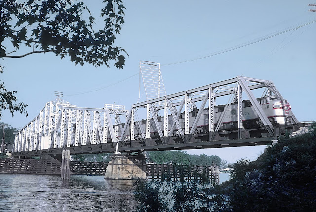
BNSF/CB&Q 1984 Bridge over St. Croix River at Mississippi River (Prescott, WI)

(Bridge Hunter, 3D Satellite)

See "Lost/CB&Q Depot" for a topo map and 1939 aerial photo of the region.

Bob Freitag shared
BNSF lift bridge, Prescott, WI from BNSF Historical Society Facebook Page.

Carolyn Susor commented on Bridge Hunter: "I call this the "Mickey Mouse" bridge because the tower sheaves look like Mickey Mouse's ears."

Ted Gregory updated
Ted GregoryTed and 1 other manage the membership, moderators, settings, and posts for Fascinating Railroad Structures. The BNSF (CB&Q) drawbridge across the St Croix is actually on the MN/WI state line. In this view, I am standing on the Prescott, WI side. This bridge can be a serious bottleneck as its double track on both ends. This is BNSF's Twin Cities to Galesburg, IL mainline. At Galesburg, IL, BNSF comes in from 6 different directions in to a massive hump yard (most traffic continues to Chicago).
Marty Bernard The BNSF does have a line from Savanna to Galesburg. Don;t know what shape it is in.
Ted GregoryTed and 1 other manage the membership, moderators, settings, and posts for Fascinating Railroad Structures. Jeff Marty I believe traffic splits near Savannah at Plum River. Priority traffic heads east to Rochelle and Aurora. Freights drop south thru Denrock, Barstow, Colona, Orion, Rio, Galesburg. South from Plum River is also old Q.
I havent beeb south of 
Savannah to Galesburg yet. Track looks really good on Google maps. I saw an auto rack train at Gburg, a rail train near Rio, on Google satellite. All I could tell you is the amount of traffic that runs through Rochelle on BNSF is nowhere near what runs out of the Twin Cities.

Zach Stagman posted
Prescott WI lift bridge
Tom Lietz posted three photos with the comment: "South bound container train crossing the lift bridge in Prescott, WI.
1

2

3

Robert Heathorn posted
BN crossing the Mississippi river to Prescott WI. No date.
Richard Fiedler shared

Marty caught the predecessor bridge.
Marty Bernard shared
5. The CB&Q's St. Croix River Bridge, Prescott, WI 1964.
Marty Bernard updated
CB&Q Bridge over the Croix River, Prescott, WI
This is the Q's crossing from Minnesota to Wisconsin as this train was doing  on June 25, 1964.
Marty Bernard posted, same comment

Marty Bernard shared
6. The CB&Q's St. Croix River Bridge, Prwescott, WI, 1964

Marty Bernard posted
This CB&Q Switch Tenders Shack is in Burns, MN at the bridge over the St. Croix River. At the other end of the bridge you can see a little of the town of Prescott, WI. To the right a few hundred feet is where the St. Croix River joins the Mississippi.

Thursday, August 30, 2018

Pennsy Cummings Branch

Dennis DeBruler posted four photos with the comment:
A Joe Usselman photo, used with permission.
Joe's comment: "A crappy shot of the BRC while standing on the former PRR Cummings branch in Chicago in 2010."
Bob Lalich commented: "The ex-PRR Cummings Branch was abandoned in the early 70s I believe, and the bridge over the BRC was removed to provide better clearance. It branched off the Ft Wayne line just west of Rock Island Jct, passed over the BRC to South Works, Rock Island and BRC to 100th St tracks on its own bridges, then paralleled the BRC down to 105th St."
Additional comments are on the photos.
1
The train in the background on the left is on the BRC-NS/Pennsy connector. It is one of the few tracks left in the Rock Island Junction. The bridges from left (north) to right are a B&OCT remnant of a Strauss trunnion bascule, 2 NYC abandoned lift bridges, a hole where a PRR lift bridge used to be, the NS/PRR lift bridge, and the Skyway.

2
This abandoned overpass over 95th street is a remnant of the branch. The trees verify that it has been abandoned for a long time.https://www.google.com/maps/@41.7227536,-87.5479789,113m/data=!3m1!1e3
3
This 1938 aerial photo caught a train on the branch so it is easy to follow the route of the branch.
4
The dark diagonal line at the top center of this 1938 aerial photo is the Cummings branch. It connected with railroads that served Wisconsin Steel that was south of 106th. This photo excerpt shows just part of the Wisconsin Steel complex.
Tony Margis: Wonder who gets credit for the research and posting of this 1938 screenshot?
Dennis DeBruler
Tony Margis It is my own work. In my blog,
I provide a link to the file from which I cropped it,
I am a heavy user of the ILHAP photos:
Bob Lalich: Dennis DeBruler - the ex-PRR Cummings Branch was abandoned several years prior to the closing of Wisconsin Steel. The line was severed at Rock Island Junction by the early 1970s. The line was originally built to serve the predecessor of Wisconsin Steel. It also served the grain elevator seen in the right center of this aerial photo. That elevator was retired and removed in the mid-60s. I believe the Cummings Branch fell into disuse afterwards, since PRR could access Wisconsin Steel and the Chicago West Pullman & Southern via the Calumet Western RR.
Ean Kahn-Treras: I was of the understanding that the Cal n’ Western ended at a yard north of Irondale around 112th or 116th St. I’m having a tough time picturing it now exactly.
Would the Cal n Western right of way extend all the way up to the Short Line and Rock Island east-west tracks just north of 95th St then? Or just far enough north to hit the CWPS house at 104th-ish?
Bob Lalich: Ean Kahn-Treras - the Calumet Western ended in the tangle of tracks just north of 106th St. It connected to the Rock Island, Cummings Branch, CWP&S and BRC.


Wednesday, August 29, 2018

(CSX+SEPTA)/Reading 1912 Bridge over Delaware River at Yardley, PA

(Bridge Hunter; Historic Bridges has 11 bridges in Buck County, but not this one; HAER3D Satellite)

Photo from HAER PA,9-YARD,8--1 from pa3720
[We see the piers of the previous Whipple truss bridge.]

Jim Perry posted
Reading RR bridge over the Delaware River. CSX & SEPTA use it now.
Shane Blische This concrete arch bridge at Yardley, P.A. was built by Philadelphia & Reading Railroad in 1913, replacing a much older wooden truss bridge co-built in 1876 by the North Penn Railroad and Delaware & Bound Brook Railroad. These two companies were constructing the National Railway which was intended to compete with Pennsylvania Railroad's New York Division (today the NorthEast Corridor). The NPRR an D&BB were absorbed into P&R by 1879. P&R reorganized as Reading Railroad (RDG) in 1924. Used by SEPTA's West Trenton Line and CSX's Trenton Subdivision, this bridge sees approximately 30 trains a day. Norfolk Southern crosses the Delaware River at Phillipsburg, N.J.-Easton, P.A. on the former Central Railroad of New Jersey truss bridge.

Tuesday, August 28, 2018

Trail/lawsuit/UP/Katy (MKT) Bridges over Missisouri River at Boonvilee, MO

(1874 Bridge Hunter, 1896 Bridge Hunter, 1932 Bridge Hunter, no Historic Bridges, John MarvigSatellite)

1932 Bridge Hunter has a timeline of the saving of this bridge. Of note, the MO AG sued the MO DNR director to not give the bridge back to UP. UP wanted to move some of the spans to another project.

The rails-to-trails web-presence

Wayne Lammers posted four photos with the comment:
Hi. I'm a new member to this FB page. These are some of my Boonville, MO Katy (MKT) railroad bridge collection. This bridge was built and finished in1873. It was changed over the years and was given to the city of Boonville. We are presently converting it to be a large part of the Missouri Katy Trail State Park. If there is interest, I will post more images of our beautiful 408 foot lift span bridge. The last photo is what it looks like now.
1
Construction of the MKT railroad bridge in 1872.

2
This is the south Boonville entrance to the finished, MK&T RR Bridge. Just look how they built bridges back some 145 years ago!!!

3
This is the reconstruction of the bridge in 1886.

4
From the center of the Missouri River at Boonville, MO
(new window)  Shot in 1986. They were still running with cabooses!


(new window)  I shoved the position indicator quite frequently.


Katy Bridge Boonville posted
An awesome image of the bridge during the flood of 1903
Charles Wells Sure looks like "Everything" is under water over at Franklin! Think this was far more a common occurrence than one might imagine, especially during spring and late fall! Too bad the Katy did not build farther up on higher ground!
The US Army Core of Engineers supports a 9-foot channel on the river to Souix City, IA. [USACE] A 2-million pound, 408' long lift span is rather impressive. If it is locked, it would have to be high enough to clear pushboats (towboats). Fortunately, that is not near as high as the old steamboats needed. I have written about preserved lift bridges that have added ramps up to the locked lift span. Of course, I now can't remember where I wrote that. And Google's Blogspot broke the author's search function on April 3, 2018, so I'm not even going to try to find the preserved lift trail.

Looking at some of the elevation shots, this bridge was built for 9-foot channel barge traffic, not steamboats, because the towers are so short. It looks like even fully raised, ramps on the bridge would have to go up just 20 to 30 feet high. It is interesting that I can't find any info on the plans for the lift span. Are they going to hire a state park ranger to operate it or are they going to lock it in the up position and build ramps? The state park system staffing a lift bridge would be a notable preservation, and tourist attraction, option. But if Missouri politicians are as incompetent as Illinois politicians, the state park system won't be funded to do anything noteworthy. (For example, the Illinois state park closed their Tunnel Hill State Trail facility.)


Monday, August 27, 2018

NS/Pennsy Curved Bridge over Tuscarawas River in Massillon, OH

(Bridge Hunter)
Satellite
Sam Busic posted
Former PRR bridge, Massillon OH, built in 1948, it curves as it spans the water, making it somewhat unique.
Herb WilsonHerb and 704 others joined RAILROAD BRIDGES, TRESTLES, TUNNELS AND CUTS within the last two weeks. Give them a warm welcome into your community! still in use?
Sam BusicSam and 704 others joined RAILROAD BRIDGES, TRESTLES, TUNNELS AND CUTS within the last two weeks. Give them a warm welcome into your community! Yes it is...I saw some Norfolk Southern cars around there today.
Dennis DeBruler Bridge Hunter indicates it is now used by a short line, R J Corman https://www.google.com/.../@40.7920858,-81.../data=!3m1!1e3
Tom Lane I think that is an awesome bridge, always loved the curve/skew combination of that bridge with vertical and enclined end posts.
It was built in 1948, which is rather late for a truss RR bridge. In the satellite image it appears you can see the piers of the previous bridge south of the existing bridge.

Paul Puljic posted
Massillon, Ohio. Picture taken from The Veterans Memorial bridge looking south.

Roger Smith posted
C03 rolls eastbound through the curved triple-truss PRR bridge in Massillon, OH. This is the trailing SD40E. 1.31.23

Charlie Easton posted
Let's make this offset bridge day. Here's the (old) W&LE offset bridge in Massillon, OH. I took this on a winter day with my old crappy phone probably 10 years ago. I should go down there and hike the canal levee trail and take a decent picture.
But back to this picture, I always saw this as a walking bridge because it looks to me like the right leg is taking a step.
[According to my 2005 SPV Map, W&LE stayed on the west side of the river.]

Also according to the 2005 SPV Map, RJCL is on the west side of the river and it is NS/Pennsy that uses this bridge. So I think Bridge Hunter is also wrong. I have changed the title of these notes from "RJ Corman" to "NS".


Sunday, August 26, 2018

1911 CN/WC/Soo/WC Arcola High Bridges over St. Croix River

(Bridge Hunter, Historic Bridges, John Weeks IIISatellite)

The "wwMiss" label is approximate. This bridge is actually over the St. Croix River.

John Weeks III

They are using cantilever bridge techniques to build the arch allows them to keep falsework out of the navigation channel.
Photo from Bridge Hunter, Public Domain: Published Prior to 1923

John Boots posted
Phil De Franco: Phoenix Bridge Company, located in Phoenixville PA for many years, had a large erecting yard near Phoenix Steel Company, and each bridge was pre-assembled in the yard to make sure everyhting fit just right prior to shipment. Their company motto was "Without fitting, filing or chipping" because each bridge was designed to be assembled on site like a giant Erector set.
Phoenix Bridge went out of business in 1962 and Phoenix Steel followed in 1988.
 
MNRails Productions posted
The Soo Line High Bridge also known as the Arcola High Bridge, is a steel deck arch bridge over the St. Croix River between Stillwater, Minnesota and Somerset, Wisconsin. It was designed by structural engineer C.A.P. Turner and built by the American Bridge Company from 1910 to 1911. Today a late CN L506 with two EMD SD60's: CN 5429 and CN 5428 cross the 2,682 foot [817m] long bridge and 184 foot [56m] above the river.
Craig A Tator: Used twice a day.
 
Joe Fishbein posted
Built in 1911 by the Wisconsin Central Railway (later, the Soo Line), the Arcola High Bridge spans the St. Croix River between Wisconsin and Minnesota.  It replaced a lower-level bridge that required steep grades on the approaches (Piers of this former bridge are still present in the St. Croix River). It is currently in service and owned by the Canadian National.
My photo, October 2019.

Jordan Palmer posted two photos with the comment:
Wisconsin Central Bridge at Arcola, Minnesota then and now. Built in 1884 by Union Bridge and Iron Works it was part of WCs route from Chippewa Falls to St. Paul. The original bridge was removed on February 28 1916 following replacement with the Arcola Highbridge completed in 1909. First photo is from Minnesota Historical Society, second one is mine from several years ago.
1

2

John A. Weeks
"The photo is a public domain image that dates back to the first decade of the 1900s."

Harvey Henkelmann commented on Jordan's posting
And here is it's famous replacement
Digitized by Google

Jordan Palmer posted two photos with the comment:
Couple more shots of my favorite bridge, the Arcola High Bridge, aka the Soo Line or Wisconsin Central Higbridge. The bridge stands roughly 185 feet above the St Croix River below at normal water level, and has five arches each roughly 300' long, plus approach trestles on each side stretching the bridge to nearly 1/2mile total length. The first photo is from a river trip nine or ten years ago now, and the second is from September of last year when I was finally able to catch a train rumbling across it. The Arcola High Bridge is now nearly 110 years old, and replaced the original Arcola crossing just down river 3/4mile that was built in the 1880s removing the long steep grades on both sides of the river as the original bridge was only about 70' above the river.
1

2
Jordan Palmer commented on his posting
One of my winter shots from few years ago.

Jordan Palmer commented on his posting
And a shot from bout 1/2 mile or so south bout five years ago.

MNRails Productions posted
The Soo Line High Bridge also known as the Arcola High Bridge, is a steel deck arch bridge over the St. Croix River between Stillwater, Minnesota and Somerset, Wisconsin. It was designed by structural engineer C.A.P. Turner and built by the American Bridge Company from 1910 to 1911. Today [Oct 9, 2023], a late CN L517 with two EMD SD60's: CN 5429 and CN 5428 cross the 2,682 foot long bridge and 184 foot above the river.
https://www.flickr.com/photos/schristie/53243837967
Ted Hazelton shared

A better exposure of the construction photo:
Digitized by Google

Digitized by Google, p 609
Digitized by Google, p 610

John boots posted
The Soo High Bridge north of Stillwater Mn. Awesome structure and best picture I’ve seen.
Jordan Palmer commented on John's post
One of my favorite bridges, I was finally able to capture shots of a train crossing it in September of last year.
Alan Ardanowski commented on John's post
Alan Ardanowski I think this is one of the hinges referenced in the above [Historic Bridges link]:Bart Culbertson Alan Ardanowski yes it is, also another term would be a pin connection.

Chip Holk posted
Train crossing the Soo Line Railroad bridge, over the St. Croix River. Washington County. 06/06/1921 (MNHS)

Tim Weinberg, Oct 2017

Leo Walding posted
This is the Arcola High Bridge between Arcola MN and Somerset, WI used by CN (x-Soo). spanning the St. Croix River. The St Croix river was a major logging river back in the late 1800's.
Jordan Palmer Hey that's one of my photos of the old Soo Line/Arcola Bridge haha! Where'd you find it?

Jordan Palmer posted three photos with the comment: "Not able to catch the train today, but snapped a couple dusk shots at the Arcola Highbridge, aka Soo Line or Wisconsin Central Higbridge, over the St Croix River north of Stillwater, Minnesota."
1

2

3

Jordan Palmer posted two photos with the comment: "Last Sunday April 19th, the Canadian National’s daily eastbound crossing the old Wisconsin Central or Arcola Highbridge, over the St Croix River north of Stillwater, Minnesota."
1

2

Jordan commented on his post
Stone footings from the original crossing about 1/2 mile south of the Highbridge. The original bridge was removed in early 1916.

Mark Kipper posted ten photos with the comment: "CN bridge over St. Croix River."
Daniel Harcourt Been over it many times no brakes allowed on the bridge per the rules.
1

2

3

4

5

6

7

8

9

10

Chris Vierling posted five photos with the comment: "The old and the new (well newer). Old train bridge pillars and the replacement bridge along the St Croix River between MN & WI just north of Stillwater."
1

2

3

4

5

Jordan Palmer posted a YouTube video link of an eastbound train.