Sunday, May 12, 2024

1894+1940s+1981 CN/Milwaukee Bridge over Lake DuBay and 1942 DuBay Dam on Wisconsin River near Knowlton, WI

Bridge: (no Archived Bridge Hunter; no Historic Bridges; Satellite)
Dam: (Satellite)

Leighton Hiller posted
My uncle lived just south of this bridge crossing Lake DuBay between Knowlton & Dancy, WI.  As a kid, I remember thinking the shared bridge was very cool.  Also remember the signs warning not to drive on the bridge while a train was crossing.
Found this page about it too. https://issuu.com/rj200/docs/dubayonline2010/s/11129533
John Strom: The other end (north end) had a curve leading onto it via car, my Dad Hated this bridge

Today's bridge:
Street View, Aug 2022

Street View, Aug 2022

issuu
The original truss was built in 1894, and later the roadway on cantilevered beams was attached. The highway, not just the bridge, was single lane! "Automobile drivers had to be extra wary because often, a wayward log slid off a rail car gondola and onto or in front of an unsuspecting car. This bridge was closed in 1979. The new highway bridge and reconstructed railroad bridge was completed in 1981."

I find it hard to believe that the pin-connected bridge made it to 1979. In fact, this part of the Wisconsin River was flooded by the DuBay Dam. and, according to the topo map below, a separate road bridge was built by 1956. I could not find any info on the bridge that had to be built in the 1940s when the lake was created by the dam.
1956 Stevens Point Quad @ 48,000

Topo maps label this railroad as Milwaukee. Wisconsin Central must have bought it when Milwaukee went bankrupt because issuu indicates WC was the owner. And because it is now owned by CN instead of CP.

issuu
The bridge has a 7' (2.1m) clearance.
.

DuBay Dam


Deidre Light, Apr 2022

The dam was built by an electric company in 1942 without a proper permit from the Federal government. [newspapers_lawsuit

But now it does have a proper license, and the capacity is 7.2mw. The "head of water" is 25.5' (7.8m). [wmcpf]

The dike is 1.3 miles (2.1km) long. [newspapers_7000-acre_lake]

The structural height is 40' (12.2m), and the width of the spillway is 330' (100m) with 11 Tainter gates. The hydraulic height is 31' (9.4m). [uslakes
What is "hydraulic height" vs. "head of water?" I would have thought they were the same, but the sources give different numbers.
 
Deidre Light, Apr 2022

Satellite

Saturday, May 11, 2024

Three SOO Crossings over Mississippi River and CN Steam Locomotive

1909 Blanchard Dam: (Archived Bridge Hunter; no Historic Bridges; Satellite, it is now a trail)
1905,1936 Camden Place: (Archived Bridge Hunter; Historic Bridges; Satellite)
They shared the Great Northern Bridge for their southern crossing of the Mississippi. Since that would have been for passenger trains, that crossing is no longer used.

See "The Rest of the Story" below as to why I researched three bridges at the same time.

Michael Kam posted
Crossing the Soo Line Bridge over the Mississippi, 12:50p [May 3, 2024]
[CPKC Empress 2816 heading to Chicago for a May 8 exhibition.]

Digitally Zoomed
.

Blanchard Crossing Bridge


BridgeHunter_blanchard
"Built in 1908 as part of the line from Brooten to Duluth; railline discontinued in 1993; rehabilitated for recreational use in 2006; reopened as a bike trail in 2007"
.

Camden Place Bridge


The bridge is 904' (276m) long with a main span of 125' (38m). [BridgeHunter_1905]

River View, Sep 2016

I presume they used a suspended steel girder span to increase the clearance over a navigation channel.
River View, Sep 2016

Street View, Jun 2019

The Rest of the Story


When I read the description on the Facebook post at the top of these notes, I did a search of the blog for the labels "wwMiss,rrWC", and got an empty result. So I did some research and found a Soo map.
Huntington

Since the Soo crossed the Mississippi in three places, I wrote a comment on the post asking for the location of the bridge in the photo. Unfortunately, when I submitted the comment, I got:
When I clicked the "Try again," I got the same result. After a few times, I was implementing the definition of insanity. (Keep trying the same thing with an expectation of a different result.) And then it would just hang with a "spinning circle." So I went on to plan B: document all three bridges. The crossing at Bowlus was easy.
For the two crossings at Minneapolis, I started with a "Minneapolis South" topo. I could not find any Soo tracks in that quadrant, so I got a "Minneapolis North" topo. That was a winner.
1952 Minneapolis North Quad @ 24,000

Satellite

Because of the suspended steel girder span in the middle of the bridge, it is easy to conclude that the Soo Line Bridge is the bridge in the photo. Camden Place is the northern neighborhood of Minneapolis. Since the Soo tracks are not labeled in the "Minneapolis South" topo, I got the topos "New Brighton" and "St Paul West," but I could not find the southernmost crossing in them. I suspected that they shared a bridge with someone else for their passenger service to Minneapolis and St Paul depots. Then John Marvig in Bridge Hunter and Historic Bridges provided the information that, indeed, the track going south in the "Minneapolis North" map connected to the Great Northern route across the Mississippi River.

Facebook Event
The train pulled by the steam locomotive is scheduled to be in Chicagoland on May 8, 2024.

The train left Calgary and is on its way to Laredo.
cpkcr

The Empress 2816 is a Hudson (4-6-4) type locomotive.
kuula

BNSF/Santa Fe Hell Canyon Bridge near Drake, AZ

(Archived Bridge Hunter; no Historic Bridges; Satellite)
 
Photo taken by Alexander D. Mitchell IV in May 2008 via BridgeHunter

Dave Blaze Rail Photography posted
Santa Fe...All The Way!
Today's repost features a southbound (timetable west) BNSF stack train heading for Phoenix crossing the famed Hell Canyon Bridge led by a pair of GEs dressed in the sharp H2 scheme
This is about MP 21.6 on modern day BNSF's Phoenix Sub (measured from Ash Fork).  The 646 long single track bridge over dry Limestone Canyon was built by Santa Fe predecessor Santa Fe, Prescott & Phoenix Railway in 1901 and still proudly proclaims the name of BNSF's predecessor to the few travelers that pass by on dusty lonely parallel County Road 71. 
Unincorporated Drake 
Yavapai County, Arizona 
Friday May 18, 2012 
Tim Shanahan shared


Friday, May 10, 2024

1908 Aban/Milwaukee Bridge over Clark Fork River at St Regis, MT

(Archived Bridge Hunter; no Historic Bridges; Satellite)

John Harker posted two images with the comment: "James C Herold caught this Milw west bound freight crossing the Clark Fork River at St Regis, Montana on July 5, 1973.  The Milw power included GP40 2058, U36C 8501 and another GP40.  This view looks to the southeast.  The bridge is still in place except for the west end in the foreground which has been dismantled over the road.  Attached is a recent aerial map for reference.  John Harker photo editing and collection."
Jessica Wray: I believe the removed girders from this bridge were used to rebuild the MRL 2nd Sub bridge over the Yellowstone River after its collapse last summer [Summer of 2023].
1

2

The BNSF locomotives in the lower-right corner are on the former Northern Pacific. That route had been operated by Montana Rail Link, but I have read that BNSF has taken that route back from them.
Street View, Sep 2008

BridgeHunter copy of Flickr Photo


Thursday, May 9, 2024

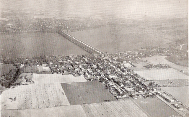
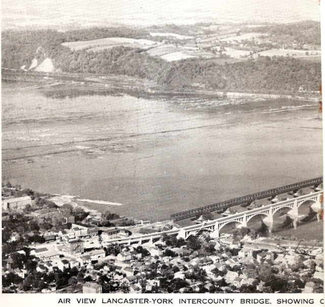
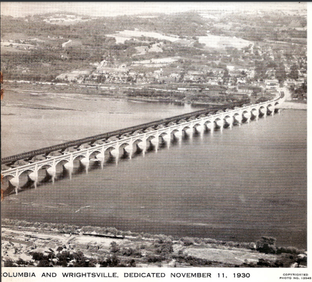
1930 Lincoln Highway Bridge over Susquehanna River between Wrightsville and Columbia, PA

1930: (Archived Bridge Hunter; Historic Bridges; HAERSatellite, 726 photos)

US-30 has been rerouted over the Wrights Ferry Bridge, which is a little upstream from here. This bridge is now called the Veterans Memorial Bridge and carries PA-462.

Historic Bridges rates the historical significance of this bridge as 10+10. "The bridge was the longest multi-span concrete arch bridge in the world when built, and even today it at the very least remains among the longest examples. In addition to its jaw-dropping 28 arch spans each spanning an impressive 185 feet, an additional 20 approach spans (mostly curved t-beams) complete the bridge which is over a mile long in total length....As of 2022, this bridge is slated for a major rehabilitation." [HistoricBridges]

HAER PA,36-COL,1--14 (CT)
3/4 VIEW FROM SOUTHWEST. - Columbia-Wrightsville Bridge, Spanning Susquehanna River at Lincoln Highway (State Route 462), Columbia, Lancaster County, PA

"Significance: When it was dedicated on Armistice Day, 1930, the ColumbiaWrightsville Bridge was the longest multiple-arch concrete bridge in the world. Twenty-eight three-ribbed open-spandrel reinforced concrete arches, each spanning 185'-0", carry the bridge across the Susquehanna between Lancaster and York counties. Another twenty spans make up the bridge's 6657'-0" total length. The span's construction was innovative because it involved the cooperative effort oftwo counties. Four bridges preceded this span at this historically important river crossing. The ColumbiaWrightsville Bridge was designated a National Historic Civil Engineering Landmark in 1984, and was listed in the National Register of Historic Places in 1988." [HAER_data]

Bob Dover posted
Almost unknown except to locals, no longer carrying a major highway, not located near any big city or major tourist sites, the Columbia-Wrightsville Bridge in Pennsylvania is a hidden gem. The bridge crosses the Susquehanna River between York and Lancaster, Pennsylvania, approximately 50 miles west of Philadelphia and 50 miles north of Baltimore. The current bridge was opened in 1930, and it is the fifth generation bridge at what is one of the most important and eventful river crossings in the early United States.
In 1863, the second bridge at this location was the focus of one of the most consequential events in United States history. In trying to reach Harrisburg in 1863, the Confederate Army needed to cross the Susquehanna River, which is one of the widest rivers in the eastern United States. While the full Army was moving eastward into Gettysburg, detachments were sent further forward to secure the Columbia-Wrightsville Bridge. These detachments cut the Northern Central Railway line at Hanover Junction 30 miles east of Gettysburg, captured the town of York, and then on June 28, 1863, reached the shore of the Susquehanna an additional 13 miles further east at Wrightsville. They were too late. The wooden bridge was burned by Union troops, foiling the Confederate advance, and giving the Union’s Army of the Potomac time to reach Gettysburg and begin the battle three days later. If the Confederate Army had succeeded in capturing the bridge, they likely would have continued on to Harrisburg and threatened Philadelphia, possibly resulting in a different outcome of the Civil War.

Street View, Aug 2022

This exposure more clearly shows the piers of a former bridge.
Street View, Nov 2021

I presume the now abandoned piers held this bridge.
Wikipedia, Public Domain

"Built in 30 days in 1896 to be "temporary" replacement for destroyed covered bridge, with intent of road being added to upper level; neither replacement nor upper deck ever built. Removed 1964" [BridgeHunter_1896]

We can see both bridges when they dedicated the new one.
dedication, p19, cropped

dedication, p24

dedication, p25

A history of the previous bridges starts on p29 of dedication and construction starts on p40.


Wednesday, May 8, 2024

I&M Canal: #13 and Split Rock

Lock: (Satellite)
Split Rock: (Satellite, the old tunnel has been overgrown by trees)

Christie Pasieka posted two images with the comment:
Lock 13
Story of Lock 13
I have been creating a series of art pieces of history no longer standing, this is one of them below.
Don Lavotny: As a kid in the 1960s I remember riding my bicycle along the towpath east from LaSalle and finding the abutments which must have once been lock 13. At the time I had no clue what it was for.
1

2

Dennis DeBruler commented on Christie's post
Could someone drop a pin on a map and share the URL for the location of this lock? Not even the Illinois Department of Natural Resources knows where the lock is.   https://dnr.illinois.gov/.../doc.../imcanalwesthuntermap.pdf
Christie Pasieka: Dennis DeBruler right about where the 93 is in the map.

Dennis DeBruler commented on Christie's comment
Thanks. Judging from this 1937 aerial photo, https://clearinghouse.isgs.illinois.edu/.../0bwy03036.jpg, it was about a third of the way from the creek crossing to Split Rock. I wonder why they built a dam and flooded the lock.

Flooding the lock with a dam explains why the canal is so wide at the lock in Joe Balynas' Flickr photo.

Tuesday, May 7, 2024

I&M Canal: Lock: #9 and #10 in Marseilles, IL

#9: (Satellite)
#10: (Satellite)

Illinois and Michigan Canal Photo Tour posted
Wonderful rendering of the canal at Lock 10, Marseilles. The grain elevator eventually burned to the ground.

1940 Marseilles Quad @ 62,500

These two locks are just a block apart. It makes sense that there is a steep gradient here because the Illinois river needs a canal and a lock to get around the rapids that were here. And that gradient is why there used to be a lot of water power mills in this town. 
Satellite


Monday, May 6, 2024

B&O Bridge over Black River near Lodi, OH

(Satellite)

There are no leafless street views available.
Street View, Jul 2014

4 of the 18 photos posted by Moses Zacharewicz with the comment: "Today [May 4, 2024] was the B&O Railroad Historical Society mini convention in Grafton OH.   It is a true pleasure to hear in person the stories of the railroad, some which have been passed down for generations.   I brought a few models along, including the B&O (CV&T) station in Cleveland, and a couple attendees told me stories how they used to work in the actual building."
Moses Zacharewicz shared
a
The Lodi Stone Viaduct over the Black River

b
Beautiful scene that is hard to see from the highway once the trees reach full bloom

c
Another view from below


d
The gate to this road was open this day, so I was able to get on the road that passes under the arch
John Carpenter: Originally the B&O intended to only erect 2 of the triple arch bridges.
They tried to force the Township to redirect the road under the western bridge and eliminate the middle bridge.
There was actually a riot, farmers and local residents were really pissed off.
There may or may not have been some gunfire. The residents tore out the work that had been done and forced the railroad to build the middle bridge.

Was this the second bridge that the B&O had planned to build?
Street View, Sep 2021 (Satellite)

And was this the third bridge that they were forced to build?
Street View, Mar 2023 (Satellite)