Friday, September 30, 2022

IHB Stewart Avenue Tower

(Satellite)

Photo by J.D. (Tuch) Santucci via dhke, closed in 1989
Also uploaded by Mike Breski (in comment) and Michael Brandt.

IHB Diagrams, p12 via dhke

Ken Schmidt posted via Dennis DeBruler
[The Stewart Avenue Tower is a little right of the center of this photo.]

I include this 1929 topo map because...
1929 Blue Island Quad @ 24,000

...I was surprised by how many streets, including Stewart Avenue, didn't actually exist in 1939.
1939 Aerial Photo from ILHAP

I was even more surprised that I could not see the tower north of the mainline. (I included some boxcars to show that a building should be casting a shadow.) So I'm confused.
At photo resolution

Of course, it doesn't show up on a contemporary image.
Satellite


Thursday, September 29, 2022

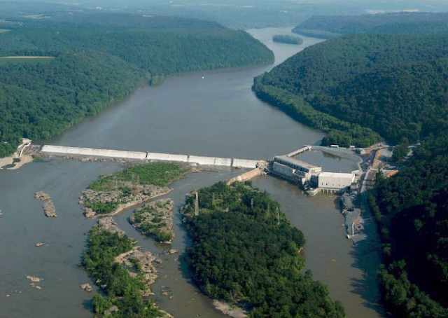
1910+2013 230mw Holtwood Hydro Plant on Susquehanna River near Airville, PA

(Satellite)

I wonder if this is the largest fixed-weir dam in the USA. This photo was taken before another powerhouse was added in 2013. 
usfwsnortheast, Holtwood Dam, Susquehanna River Credit: USFWS

This shows the additional powerhouse that was built east of the original powerhouse.
LowImpactHydro
"The dam is an overflow-type structure that consists of a 2,368-foot-long by 55-foot-high, low hazard, concrete gravity dam. The top of the dam is raised 4.75 feet to an elevation of 169.75 feet via the use of wooden flashboards and inflatable rubber dam sections....The original powerhouse contains ten similarly sized vertical Francis turbines and two smaller vertical Francis turbine generator units, with a combined installed capacity of 171.4 MW. The new powerhouse contains two vertical Kaplan turbine generating units with a combined capacity of 80.6 MW....The project supplies a continuous 200-cfs minimum flow to Piney Channel to provide suitable habitat for resident fish species. Additionally, the project provides a continuous base flow of 800 cfs and a daily volumetric flow equivalent either to 98.7% of the inflow requirements of the downstream Conowingo Project or to the daily net inflow to Lake Aldred, whichever is less."

HydroReview
The $440m expansion was completed in 2013 and it included improved fish passage and a whitewater park. Construction began in 2010.

PAheritage
Construction began in 1905. "It was then the third longest dam in the world, built of solid concrete, 55 feet high....n 1912 the installation of the world’s first Kingsbury thrust bearing at Holtwood revolutionized the industry. The same thrust bearing remains in operation today and was designated as a Historic Mechanical Engineering Landmark by the American Society of Mechanical Engineers in 1987." It was built with two fishways. But they proved to be ineffective. Several fish passages have been tried since. An elevator lift was installed in 1997 and in 2014 modifications to the lift were completed.

ASME

ASME-brochure, p2

SatelliteLowImpactHydro has more information about the fish passages
"Shad and river herring are returning to their spawning on the Susquehanna at their lowest numbers since the 1980s, according to Exelon's news release. The population peaked in 2001, when hundreds of thousands of shad and river herring passed Exelon's Conowingo Dam, but that number has dwindled to 1,500 shad and 1,000 herring per year.Shad and river herring are returning to their spawning on the Susquehanna at their lowest numbers since the 1980s, according to Exelon's news release. The population peaked in 2001, when hundreds of thousands of shad and river herring passed Exelon's Conowingo Dam, but that number has dwindled to 1,500 shad and 1,000 herring per year....Per the new agreement, Exelon will invest millions of dollars to improve its dam's fish passageways and transport up to 100,000 American shad and 100,000 river herring to their spawning grounds through a trap-and-transport program each year, according to the release." [YorkDispatch, limited articles remaining]

UnchartedLancaster
230mw
"The oldest of the still operational lower Susquehanna dams is the Holtwood Dam, constructed between 1905 and 1910. Originally called McCalls Ferry Dam, it was later renamed in honor of two Pennsylvania Water & Power Company executives."
This photo is also in LancasterOnline

LowerSusquehannaRiverKeeper

Anthony Turner, Feb 2017

Tsvetan Nikolov, May 2020

The river can also get very low.
SueReno, her page also has photos of Lock #12 of the Susquehanna and Tidewater Canal.

SusquehannaRiverLands, this view is from the Face Rock Overlook.
"This observation point is located off Old Holtwood Road in Lancaster County.  It offers a view of the Holtwood dam, power plant, fish lift, and the Susquehanna River.  Interpretive signs and a map provide visitors with important information about the area."

reddit
Holtwood Dam, Pennsylvania. Person for scale.

I recognize the notch in the dam in the above photo. That photo would have been taken on the west side of the river.
Satellite

I think this is the 10" pipe that guarantees a minimum 200cfs flow to keep the fish alive. It also helps add disolved oxygen to the downstream water.
Satellite

Atkinson Construction
"This project features a [67'] tunnel from the Draft Tube Unit #1 of the Holtwood Powerhouse to the other side of the diversion wall. This created a controlled water flow to help the American Shad fish migrate upstream past the dam and also created water features for kayakers to enjoy."

WalshGroup has three photos concerning the 2013 construction of the additional powerhouse and improved support of fish migration.
1

2

3

LancasterOnline
$4m was spent on a whitewater park on the west side of the dam. It reused an old fish ladder and has a flow of 755cfs. The power company had to build this because their expansion project had removed "many of the riverbottom boulders that had created what some considered the best playboating features on the East Coast [I hit a paywall trying to access that link.]."


Wednesday, September 28, 2022

NS/Southern James River Bridge in Richmond, VA

(Bridge Hunter; Satellite)

Larry Jenkins posted two photos with the comment: "Built by Southern Railway, the Norfolk Southern James River Bridge in Richmond is 2,000 feet long. On the other side of the river, the tracks turn right and lead to the lower section of the Triple Crossing. Above the tree line to the right is the red-tiled roof of the “Richmond Main Street Station”. This is the view of “The Vista’s”, my condo from across the river."
[I changed the order of the photos so that the bridge would be first.]
2

1

Dennis DeBruler commented on Larry's post
While looking at a satellite map, I noticed that both ends go through a floodwall. How often is the route out-of-service because gates had to be installed to close the floodwall?
The north end: https://goo.gl/maps/6MQqdHKukSNAd2uQ7

Larry Jenkings commented on Dennis' comment
I've only been here a year and they closed it once for a short period for yearly maintenance. There are actually three gates on the Norfolk Southern, one is across the river on the south shore. The second level of the Triple Crossing on the CSX Line also has one on the southern shore.

I was confused by the Bridge Hutner photos because some photos showed a girder bridge and others showed a truss bridge. Then I learned that the bridge has both types of spans. Over half the length of the bridge consists of girder spans, but the middle has truss spans.
3D Satellite

A lot of the bridge is hidden by trees.
Street View

Street View

And some of the spans are arches.
Street View

Judging by the transition from cut stone to concrete in some of the piers, it appears this part of the bridge used to have deck trusses. The 100% concrete piers indicate that the girder spans are half the length of the original deck truss spans.
Nov 2017 Photo by Royce and Bobette Haley via BridgeHunter


Tuesday, September 27, 2022

1915 NS/NYC/LS&MS Movable Bridge over Portage River

(Bridge Hunter; Historic BridgesSatellite)

Marty Bernard posted
CR C40-8W 6146, C40-8W 6070 and GP40-2 3309 along Sandusky Bay, OH in 1993 Karl Miller photo.

Dennis DeBruler commented on Marty's post
This bridge is the next bridge west of the Sandusky Bay Bridge. It is the Port Clinton Bridge over the Portage River. It replaced a swing bridge in 1915. It is considered the first 4-track bascule bridge ever constructed. If you look at the satellite image, it appears that two of the tracks were cantilevered on the sides of the main truss. Those tracks are cantilevered when the bridge is not closed. Karl's photo shows the heavy girders on the outside of the movable span. Those girders help carry the live load of trains when the bridge is closed. So the tracks are not contilevered when the bridge is closed.
https://www.google.com/maps/@41.5156139,-82.9635979,178m/data=!3m1!1e3

The side girders have their own trunions.
A postcard of the construction via BridgeHunter
[Note the falsework under the counterweight.]

Douglas Butler posted
Unknown source: NS Railroad Strauss Heel Trunnion Bascule Bridge located in Port Clinton, OH crossing the Portage River.

The predecessor swing bridge:
BGSU via Bridge Hunter, License: Creative Commons Attribution (CC BY)

NorthAnmericanInterlockings via Bridge Hunter, License: Creative Commons Attribution-Share-Alike (CC BY-SA), David P Oroszi Collection


Monday, September 26, 2022

Oct 6, 2021: Crane-like device fell off the Red Line, no serious injuries

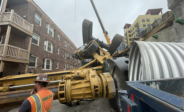
This rig was digging piles for Phase 1 of the CTA Red-Purple Modernization Program. There were no serious injuries.

Chicago Fire Department via BlockClubChicago
"The yellow crane fell into a nearby alley, crushing a nearby car, downing power lines, causing a utility pole to nearly topple over and damaging some fencing on a nearby apartment building. The crane cab was inverted, fire officials said." People were evacuated from an apartment building because of live power lines on the ground.
It fell about 3pm and shut down the Purple Line service throughout the afternoon. Red Line trains skipped the Bryn Mawr station until about 9pm.
 
The news reports say it lost its balance. But it was reducing its overhang as it slewed. I suspect that a support gave way.
0:19 video @ 0:16
At 0:12 note the worker by the port-a-potty realizing that he needed to be somewhere else. And have the sense to go sideways as soon as he could.

Chicago Fire Department via BlockClubChicago
The mobile crane in the background was not involved in the incident.

Not only does this show the crushed car, it shows that at least three transformers fell of a pole. I wonder if they had oil with PCBs.
Provided by Christopher Corbett via BlockClubChicago

The thing that fell off the elevated track was a foundation/piling rig. [vertikal]
 
This view clearly shows that it was not a crane, but a drill rig.
Chicago Fire Department via enr
The drill rig, an IMT International AF 300 mounted to a Cat 349D hydraulic excavator base, is typically used for foundation piles, and can work at depths of up to 75 meters.

This article specifies a cost of $2.1b for the modernization project. I had been reading a cost of $1.7b.

ChicagoTribune, Photo by Chris Sweda
The incident happened near 1119 W. Bryn Mawr Ave.

Fox32chicago, Photo credit: HuronTrader/Twitter, cropped
The evacuees were provided overnight shelter....Occupants of the evacuated building won’t be able to return until the drill rig is cleared.

Berkin 4C Tweet, Photo credit: Berkin Ozisikyilmaz via cbsnews

It has been almost a year later. I tried looking for the results of an investigation, but I could not find anything.