| Street View, Oct 2012 |
This 13km (8 mile) bridge was built in 1974 and saved a trip of 100km (62 miles). [TripAdvisor]
Britannica give a length of 9 miles (14.5km).
The official name is "President Costa e Silva Bridge....At roughly 8.26 miles (13.29 kilometers) long and 232 feet (70.7 meters) high at its peak, the Rio–Niterói Bridge remains one of Brazil's engineering marvels." It handles 140k vehicles/day. [viator] (Another source agrees with the 13.29km figure.)
 |
| Highway Engineering Discoveries posted Ponte Rio-Niterói Bridge |
It appears to be a concrete box girder bridge.
 |
| Street View, May 2021 |
 |
| datajembatan, 3rd of 6 photos "It is currently the longest prestressed concrete bridge in the southern hemisphere, and the sixth longest in the world. From its completion in 1974 until 1985 it was the world's second-longest bridge, second only to Lake Pontchartrain Causeway....It is 13.290 kilometres (8.258 mi) long – 8.836 kilometres (5.490 mi) over water and the bridge's central span is 72 metres (236 ft) high." |
2 of 14 photos from BrazilTravelBuddy including the comment: "The Rio-Niteroi Bridge is building a superlative: the longest bridge in the Southern Hemisphere, the longest span continuous straight beam in the world, the central span of 300 meters in length, the most important prestressed structure of the Americas, with more than 2150 km cables in their structures, [and] one of three major bridges in the world in spatial volume." [This source indicates the bridge is 72' tall in the central span. They obviously meant 72m (236').]
 |
| a |
 |
| b |
 |
| engbim |
Note the big dolphins in front of the main piers and smaller dolphins in front the of the five adjacent piers.
 |
| engbim |
This is the photo that caused me to look for the dolphins in the above photo. I include it because it shows the heavy ship traffic in the area.
 |
| engbim |
 |
| Tela Vicente, Feb 2023 |
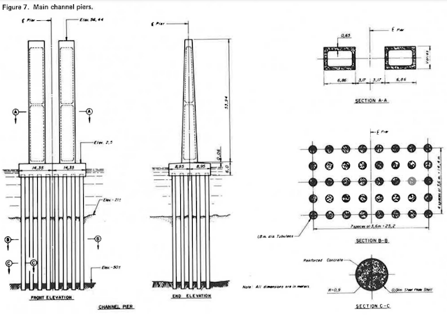
This shows that the main piers are as deep as they are tall and that the piles go down to bedrock.
 |
| onlinepubs, p 3 |
The pilings for the 80m (262') approach spans go down to "competent founding strata." Gantries were used to lift prestressed concrete segments into place. The segments were then post-tensioned to make a continuous span. [onlinepubs, p 1] The use of gantries and post-tensioning is commonplace now, but I think it was bleeding edge back in 1974.
No comments:
Post a Comment