(
Bridge Hunter; no Historic Bridges;
Satellite)
 |
USGS (U. S. Geological Survey), Public domain, via Wikimedia Commons
Schoharie Creek Bridge collapsed |
The replacement bridge.
 |
uticaod
"Schoharie Bridge Collapse Looking south over bridge approx. 4 hours after collapse. Source: New York State Thruway Authority" |
 |
uticaod. photo by Utica resident Toni DiMeo
[This shows the slope failure under the north side of the west abutment. And the erosion down by the river that caused that failure.] |
 |
| uticaod. photo by Utica resident Toni DiMeo |
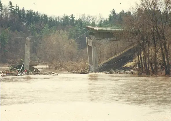
The flood was the result of the double whammy of snow melt and an intense Spring rain. The normally 6' deep Schoharie Creek was 25' deep. The first span fell around 10:45am. Another span dropped about 1:15pm. [
DailyGazette, paycount 2]
Four cars and one truck fell 84' into the creek. "The cause was determined to be a failure to properly design, build and maintain the bridge. Built in the 1950s, the bridge's supports had concrete footings dug 6 feet into the riverbed, instead of piles driven into the bedrock needed because the riverbed soil was vulnerable to washing away." [
TimesUnion]
"A rebuilt bridge was fully opened to traffic on May 21, 1988. The legacy of the tragedy was a reexamining of the way the state inspected its bridges. A Federal Highway Administration report fourteen months after the collapse found over two-thirds of New York State's bridges to be deficient, the highest percentage in the nation. The state took over examination of all bridges, including those owned by the Thruway Authority and local governments. 'It drew attention to the way that the bridges were inspected, to the degree of inspection and to the need for underwater inspection for piers and abutments,' John Seligman, director of infrastructure services for Spectra Engineering, told the Post-Standard in 2007." [
syracuse]
Since it took over a year to build a replacement bridge, a
1910 railroad bridge that was being used for a trail was converted to a road bridge in a couple of months to help handle the detour traffic on NY-5S.
 |
| uticaod, Source: New York State Thruway Authority |
I changed the order of these photos to try to put them in chronological order.
 |
| uticaod, Source: New York State Thruway Authority |
 |
| uticaod, Source: New York State Thruway Authority |
 |
| uticaod, Source: New York State Thruway Authority |
 |
| uticaod, Source: New York State Thruway Authority |
 |
| uticaod, Source: New York State Thruway Authority |
 |
| uticaod, Source: New York State Thruway Authority |
Some of my takeaways:
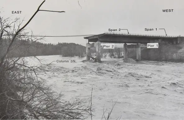
- The scour hole under pier 3 was 9' (3m) deep and 25' to 30' (7.5m to 9m) long.
- "The state also required diver inspections of the underwater structures every five years." But it had never been inspected in over three decades.
- The design called for the sheet piles to be left in place and for the excavation to be backfilled with riprap. Instead, the piles were removed and the excavation was backfilled with erodible soil and topped off with some riprap.
- A 1955 flood had probably removed the little riprap that had been placed by the pier.
 |
Facebook Reel
I stopped watching when they started asking a police officer how hard was it to work here. |


No comments:
Post a Comment