(If a caption has a hot link for "Dennis DeBruler," then that is a link to my notes about that specific flood. In other words, these notes are an index of notes that I have written about flood issues.)
In short, there was way too much rain in too little time. Several river level records set in 1993 have been broken.
And then I learned that BNSF+Dakota & Iowa Railroad lost a bridge over Big Sioux River at North Sioux City
And quite a few towns east of IA-60 besides Spencer were flooded. For example, Sibley. (These are UP tracks.)
.png)
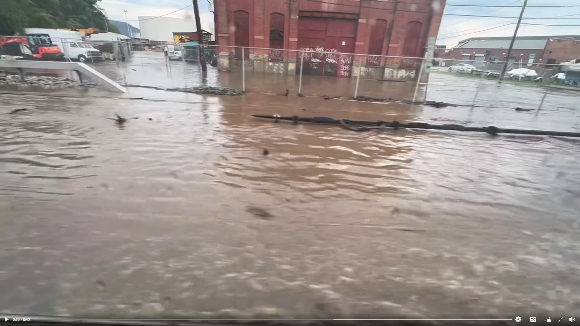
This Jun 24, 2024, video provides a nice "big picture" overview of the flooding because they are concerned about how this year's agriculture production will be impacted. They say corn under water for just two days will die. And I'm sure that late June is too late to replant. And farmers are losing their product after they have spent on fertilizer as well as seed.
 |
| 21:23 video @ 5:03 |
On Sun Jun 23, 2024, the Chicago Tribune had an article about flooding in parts of Iowa. The Tribune normally doesn't cover flooding outside of the Chicagoland area, so I knew that if they were talking about it, then it must be bad. One town they mentioned was Spencer, IA. I had learned from a Facebook comment that a levee broke in this town.
 |
| Dan Gottschalk posted via Dennis DeBruler |
The other town that the Chicago Tribune discussed was Rock Valley, IA. "Sierens blared at 2 a.m. in rock Valley, Iowa, population 4,200, where people in hundreds of homes were told to get out as the Rock River could no longer take rain that has slammed the region." The area had 4 inches in an hour and a half.
 |
| Chris VB via REUTERS via DesMoinesRegister via Dennis DeBruler |
I first learned that things were wet on the plains states with a post about a BNSF derailment.
.png) |
| Warrior Sports Photography via Dennis DeBruler |
And then I learned that BNSF+Dakota & Iowa Railroad lost a bridge over Big Sioux River at North Sioux City
 |
| James McCabe Jr. via Dennis DeBruler |
The museum east of the bridge has also been flooded.
 |
| Ben Brown via Dennis DeBruler |
And the town west of the bridge, North Sioux, has been flooded. In fact, some of the homes have been washed away.
 | |
|
While studying the record high river in Sioux Falls, SD, I learned that I-29 was closed between Sioux City and Sioux Falls. And one could not use the side roads to get around the closure because they were in worse condition. The state police suggested that a viable detour was to go up US-75 to Le Mars and then use State Route 60 to Worthington where you can take I-90 back to I-29. [ktiv] The fact that they have you use State Route 60 rather than US-75 indicates that quite a big area around Big Sioux River must have been under water. Later, I learned about what the Rock River had done to Rock Valley.
%20Facebook.png) |
| Sioux Falls Government via Dennis DeBruler |
And quite a few towns east of IA-60 besides Spencer were flooded. For example, Sibley. (These are UP tracks.)
.jpg) |
| Ryan Van Wyk post via Dennis DeBruler |
Then I realized that State Route 60 must be built on a ridge between the watersheds of Big and Little Sioux river. This Google Maps display that I came across illustrates this.


I wondered if this is enough water to impact the Missouri and Mississippi Rivers when it finally flows further south. Or is this just a drop in the bucket for the big rivers? I have read that they are predicting that the Mississippi River will flood. At least excess water in Duluth and Gooseberry Falls flows to the Great Lakes instead of the Mississippi River. But the water that breached the Rapidan Dam is headed to the Mississippi River.
 |
| 8:03 video @ 0:25 via Dennis DeBruler |
St. Peter, MN, downstream from the Rapidan Dam on the Minnesota River
 |
| 0:40 video via Dennis DeBruler |
Henderson, MN, is further downstream from the Rapidan Dam on the Minnesota River, and it has broken its record river level.
 |
| 1:55 video via Dennis DeBruler |
Jun 29: Omaha Bridge over Mississippi River in St. Paul, MN
 |
| 19:31 video @ 6:46 via Dennis DeBruler |
Jun 30: I-29 is flooded north of Omaha.
Muscatine is close to L&D #16. Jul 5:
Update: almost three weeks later, the locks are opening again.
%20Facebook.png) |
| Facebook reel via Dennis DeBruler |
Even the desert states are getting hit hard. US-70 in Ruidoso, NM, became a river after rain dumped on burn-scarred mountain sides. A comment explained that the wildfires leave ash on the ground that seals the surface and does not allow the rainwater to soak into the soil.
 |
| 0:26 video via Dennis DeBruler |
I passed up a bunch of Facebook reels concerning rain in Moab, Arches National Park, Provo River, etc., but Las Vegas getting 8" in late July is worthy of note.
 |
How do I find the date on a Facebook reel?
%20Facebook.png) |
| Facebook reel |
A comment indicated this is the worst that he has seen.
%20Facebook.png) |
| Facebook reel |
Jul 2:
 |
| USACE, Rock Island District posted Due to high water on the Mississippi River, the Rock Island District has closed the locks at Lock and Dam 12 (Bellevue, Iowa), Lock and Dam 16 (Ilinois City, Illinois) and Lock and Dam 17 (New Boston, Illinois) to all traffic. These closures will remain in place until the river recedes and equipment re-installation and cleanup can take place. Visit our lock status website for the status of all locks within the District: Terry Beine: Quite the opposite of 2 years ago when there were spots on the river that were nearly walkable shore to shore. Debbie Hansohn Felsing shared |
Muscatine is close to L&D #16. Jul 5:
 |
| noaa |
Update: almost three weeks later, the locks are opening again.
 |
| Jess Sherwood posted on Jul 19, 2024 Lock 18 opened back up today. 10 boats waiting to lock thru northbound 😁 Then they are just going to 17 to wait again. 16 and 17 are supposed to open Sunday [Jul 21]. |
Jul 5, Mill Dams in Manawa, WI, and in Faribault, MN
 |
| nbcnews via Dennis DeBruler |
Jul 5: Captain Meriwether Lewis Dredge Museum on the Missouri River
 |
| Captain Meriwether Lewis Dredge posted via Dennis DeBruler |
Jul 6: Davenport, IA
 |
| Raw Images Art & Photography posted via Dennis DeBruler |
Jul 8:
 |
| usace |
The river was already high in June 2024.
.png) |
| Street View, Jun 2024 via Dennis DeBruler |
And was still high July 23, 2024.
.png) |
| David Webster posted via Dennis DeBruler |
And other parts of the country got hit last April.
In early April, Pittsburgh saw new record high river levels on the Ohio River.
.jpg) |
| Dave DiCello via Dennis DeBruler |
A record flood in Pittsburgh caused a "moderate" flood in Wheeling and crested at over 41'. This is Wheeling Island.
%20Facebook.png)
 |
| Apr 29, 2024, video via Dennis DeBruler |
July 9:
Hurricane Beryl hit Houston. I saw reels of destroyed homes along the Gulf coast, flooding of downtown buildings, high tension power line towers crumpled to the ground, flooded roads, etc. Over 2.7 million homes and businesses lost power, which means they lost air conditioning. Since Beryl was just a Category 1, I wonder what would happen if a major (Cat 3 or more) hurricane hit that area. And between July 8 and July 10, the cost of our gas went up 31 cents per gallon.
Ruidoso, NM, got hit with another flash flood caused by a previous wildfire crusting the soil surface and not letting the rain soak into the ground.
This was at a "US military base." The water blows those steel doors right off their hinges. And there is an even bigger wave that comes in later.
%20Facebook.png) |
| Facebook reel |
July 17, Ossining, NY
 |
| 0:40 video Coming back from the city to Croton this afternoon, the tracks were flooded in parts. This was at the Ossining train station. I don’t recall seeing this level of water during my 20 years of commuting. New York Central Railroad Fangroup shared It really was the Water Level Route. |

Laura Farms uses pivot irrigation. Normally, by this time in the summer, their pivots would have done 12 full revolutions. [video @ 1:42] This summer, there has been so much rain that they are just now starting them. Some of the rains did cause harm.
May 25: They hurried up and finished planting their corn to be done before this rain. Unfortunately, this rain washed out some of their seed.
%20Video%20_%20Facebook.png) |
| 1:25 video |
Aug 11:
%20Video%20_%20Facebook.png) |
| 0:45 video |
There not going to smooth that field out with just a disc.
%20Video%20_%20Facebook.png) |
| 0:45 video |
Aug 1, Vermont
%20Facebook%20-%20Personal%20-%20Microsoft%E2%80%8B%20Edge.png) |
| Facebook reel |
%20Facebook%20and%202%20more%20pages%20-%20Personal%20-%20Microsoft%E2%80%8B%20Edge.png) |
| Facebook reel |


Aug 4 13:35 video The land that slid suffered from a recent wildfire.
 |
| 11:37 video on Aug 4 by Casey Jones |
Aug 5 2:44 video Water is starting to go over the top
A 1:03 video showing a stronger flow over the blockage
Aug 6: Judging from more videos, the river eroded through most of the blockage in less than a day. Someone stated that the downstream river level got no worse than the levels during some Springs. But the flow was faster and full of debris, so the erosion downstream was worse. One scene had a house falling into the river because the bank eroded away under the house. And debris is now flowing down the Fraser River.
 |
| This 9:22 video by Casey Jones at 3:01 is the best description I saw about the emptying of the "lake" on Aug 5. But Casey missed the house that fell into the river. The screenshot is the predicted height of the pulse of water that is expected at various downstream locations. |
Aug 4, Tropical Storm Debby dumps rain on Tampa and points northeast
And they are predicting that it will stall over southern Georgia. I've seen predictions of 30" of rain in Georgia and South Carolina.
 |
| 7:58 video @ 2:49 |
In addition to 6-12 inches of rain, storm surge is an issue.
 |
| @ 4:40 |
I was not surprised that I saw several videos of flooding in the Carolinas, but I was surprised that there was significant flooding in PA and NY. There are so many videos that I'm going to note just this one because you can see what the normal flows look like in Portage Bridge over Genesee River in Letchworth State Park.
 |
| Facebook reel letchworthstatepark 🍫 Tropical Storm Debby turned the Genesee River to “chocolate milk.” ⚡️Today, the rumble of the falls pounds in your chest and carries for miles, like rolling thunder and wind. 😱In just 24 hours, from Aug. 9 to Aug. 10, the river flow increased by over 2,000%. 🌱🌳At 8am Aug. 9, river flow was 272 cubic feet per second, about enough to fill 10 hot tubs in a second. Peak flow at 8am on Aug. 10 was 5,720 cubic feet per second, enough to full 250 hot tubs in a second. ⚠️As the biggest rush of storm water rolled in from 10pm to 11pm, the river increased in flow rate by hundreds of cubic feet per second every 15 minutes. Another reminder why it’s important to stay on marked trails and never swim in the river. 🛶Still, the pros with Adventure Calls Outfitters, Inc. were absolutely guiding rafting trips on the raging water today, they just asked that small children not come along this time. 🎈It’s just one of the bucket-list ways to see the Genesee River’s canyons in Letchworth…like a hot air balloon ride with @balloonsoverletchworth. 🥾Our educators lead guided experiences almost every day, year-round. Check the schedule: in bio and visit the nature center between the Visitor Center and Inspiration Point to meet the educators. |
In the Carolinas streets and buildings got flooded. In the mountainous north, the earth got gutted by the flash floods.
 |
| safe_image for Crews work to fix railroad tracks damaged in Friday’s [Aug 9] storm |
 |
| Gary Puccia posted This was formerly NYC, south of Watertown NY. I was a brakeman in the early ‘70’s, for Penn Central, and this section is commonly known as Kellogg Hill, about 6 miles from Massey Yards A few days ago we had our share of the remnants of tropical storm. Rainfall was between 3 and 6”. They expect to have repairs done in a day or so. The ground below the railroad bed is primarily sand. Frederick Albrecht: Day or 2? That’s gunna take a lot of fill and reengineering a drainage system, compacting, before even trying to setup a substantial sub roadbed, roadbed, and lay new track, ballast tamping. [After a comment mentioned a month or two.] Joshua Scott: Gary Parks they are gonna be running trains Tonight.[Aug 13] round the clock 50+ dump trucks and off road haul trucks running stone.. panels are already laid.. get with the program guys.. rr doesn't f around when it comes to mainline like this. Joshua Scott: Gary Parks talked to track guy this morning [Aug 14]. Traffic is rolling as of about noon.. slow ordered but mainline is fixed.. I see if I can get some precious pics lmao |
No comments:
Post a Comment