This photo shows how they have to split the standard tow in half in order to get through the 600' lock. I noticed that this is a 16-barge tow instead of the typical 15-barge tow. I don't understand why they don't normally put barges next to the towboat to get a 17-barge tow. It is very rare to have even the 16th barge.
 |
| USACE-locking |
 |
| USACE-fact-sheet, p1 "The maximum lift is eight feet with an average lift of four feet. It takes approximately seven minutes to fill or empty the lock chamber. The movable dam has eight submersible Tainter gates (20 feet high by 64 feet long) and three submersible roller gates (20 feet high by 100 feet long). The dam system also includes one non-overflow earth and sand-filled dike; two transitional dikes; and a submersible earth and sand-filled dike." [This is a more typical 15-barge tow doubling through the lock.] |
 |
| HAER ILL,66-NEBO,1- |
Significance: The U.S. Army Corps of Engineers Nine-Foot Channel Project (1927-1940) represents the culmination of a 100-year effort to improve the navigability of the Upper Mississippi River between the mouth of the Missouri River and Minneapolis, Minnesota. This specific project arose as a response to the farm crisis of the 1920s. Proponents of the New Deal adopted the project and gave speed to its construction as a means of providing public enjoyment during the more general depression of the 1930s. By the 1940s, the completed project had converted over 650 miles of free-flowing river into a series of interconnected reservoirs which ensured enough water for fully loaded modern boats and barges to navigate the system. This constituted a significant alteration of the natural environment of the Upper Mississippi River. However, the project also brought economic benefits to the communities along and around the river corridor and lead to new recreational opportunities for the entire region. [HAER-data]
 |
| HAER ILL,66-NEBO,1-, cropped 11. VIEW OF ROLLER GATE #6 BEING ERECTED, VIEW FROM SOUTH. June 1938 |
 |
| USACE, Rock Island District posted Today's #FlashbackFriday takes us back 87 years to the construction of Lock and Dam 17 in New Boston, Illinois. Construction on the dam would be completed in January of 1939 with lock and dam operation starting May 14, 1939. Happy belated birthday Lock and Dam 17! |
 |
| USACE, Rock Island District posted Today's #FlashbackFriday takes us to Lock and Dam 17 on the Mississippi River near New Boston, Illinois. This photo, taken January 7, 1938, shows construction of the dam complex. A total of 1,573 men were employed on this construction project at one time or another, with 626 men working on the peak day of construction which was July 8, 1936. |
 |
| JohnWeeks |
This Apr 2019 flood image is currently on Google Map. (I used Google Earth to find the date.) I realized I was looking at high water when I could not see the fixed embankment part of the dam.

A closeup shows the gates are wide open and the lock walls are almost under water. Barge traffic is obviously shutdown and the lock is being used as a safe haven to park some equipment. There is a crane on the big barge.
 |
| Satellite |
The lock walls did become submerged. I wonder where the electric motors that operate the gates and valves are located.
 |
| TheGazette Bloomberg Floodwaters surround Lock and Dam 17 on the Mississippi River as seen in an aerial photograph taken near New Boston, Ill., on Friday. "Hundreds of barges are stalled on the Mississippi River." [paywall] |
I fired up Google Earth to get a more normal image of the river. I learned that in many of the images the fixed embankment was under water. But here is one with it exposed.
 |
| Google Earth, Sep 2017 |
But the water seems to be almost as high on the downstream side of the roller gates as it is on the upsteramside.
 |
| Google Earth, Sep 2017 |
 |
| Dewatered, photo 1 During a winter 2017 dewatering at Lock 17, crews accessed areas of the lock not normally exposed and repaired damaged portions of the concrete wall. |
 |
| Dewatered, photo 2 A hydro-demolition machine being used at Lock 17 on the Mississippi River to remove old concrete from the lock walls. |
 |
| USACE-fact-sheet, p2 |
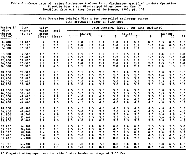
There is so much detail in this document that I had a hard time understanding it. I was hoping to get a feel for how much water these river dams pass to compare with discharge rates for spillways in reservoir dams. I did learn that the gates are submerged in the winter when there is no navigation on the river. That would allow the ice to flow over the gates. I think the 65.5 kcfs in this table is the flow during normal operations when the upper pool is at 9.3'. Flood flows would be way above this figure because the gates would be wide open and water would be flowing over the fixed embankment.
 |
| USGS, p48 via pubs |
Because the calibration of this gauge is too lax, the data is retained for only 120 days. The data is not considered suitable for archiving. So I can't find the levels for last Spring, let alone the 2019 floods.
 |
| waterdata |
 |
| David Webster posted Angel Binner: Lock 17 Dennis DeBruler: Did you get a photo of the big crane? David Webster: Dennis... I didn't think about it ... but I'll fix you up when I see it again |
 |
| David Webster posted Haven't lost my touch..Webbie 1.... Asst Boat 0 Chris Rowland: Lock and dam 17 the milo m is the boat on the wall Alli Wheeler: Chris Rowland Captain Wheeler in Milo 😉 Dennis DeBruler: A nice view of the Quad Cities crane. When the roller gates are up out of the water, are the miter gates open? That is, can you shove a tow through the lock or do you still have to wait for gates to close and then open? If you have to wait, I assume it is because of a strong river current. David Webster: Dennis, the locks on the upper are not made to " drive thru or around " like a few other rivers have locks you can do that with ... The Illinois River has 2 locks you can drive the pass ( Lagrange & Peoria ) , & the ohio river has Olmstead, John T Myers, & Newburg ... Smithland Lock can be done but industry has shyed away from " jumping the pass " because it hasn't been done in so long.. [I didn't mean go around the locks. I meant going through the locks with the gates open at both ends. But I didn't want to waste anymore of his time. His answer is a list of the dams that still use wicket gates.] |
This was the photo that motivated me to look at D&L #17 because this photo struck me as a high dam for the Mississippi River. I soon realized that this was a different D&L #17.
 |
| Craig Dodson posted Lock 17, the uppermost dam on the black warrior |
 |
| USACE, Rock Island District posted |
No comments:
Post a Comment