Sunday, April 30, 2017

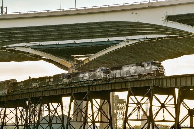
1891 and 1972 Norbert F. Beckey Bridges over the Mississippi River at Muscatine, IA

(1891 Bridge Hunter1972 Bridge HunterJohn A Weeks IIISatellite)

While studying the location of a couple of depots in Muscatine, IA, I noticed the Mississippi River bridge moved. It used to be an extension of Walnut Street.

1938 Aerial Photo from ILHAP
When I first saw pictures of the old bridge, I thought it was just another suspended span cantilevered truss bridge that we have now seen replaced several times. But when I read that it was built in 1891, I dug deeper.

Oscar Grossheim1909  photo from the Musser Public Library
It was built with steel cylindrical piers. But, in 1899, a crew of men and a team of horses pulling a load of logs fell 40 feet with the bridge when a piece of ice slammed into the third pier. All of the piers were rebuilt with stone from Cedar Valley, Iowa. The referenced photo shows the old steel piers. (I wonder if this was a quarry. Nature does not make 90-degree angles. There are three other "water pools" in this area along the shore of Cedar River that were probably quarries.) This 1899 collapse evidently taught engineers that steel piers should not be used in rivers because you now don't see any, even in older pictures.

Oscar Grossheim 1909 photo of the levee and High Bridge from the Musser Public Library

Raymond Story posted
MUSCATINE IOWA  [Rock Island depot]
J Pete Hedgpeth: See that long and old hiway bridge in the background. It was finally replaced in the 70's after terrorizing my daughter on our trips from Chicago to Lincoln, NE by its rattling and banging as we drove over it and causing H J Heinz company to have to "float" the tomato hauling trucks every summer across the river on barges from the "Patches" on the east side of the river to the "factory" in west Muscatine where they were turned into Ketchup and juice.

If you look at the Bridges--Muscatine search results, you can seem some pictures during the 1922 flood. All of this levee was covered by water because the water had been on top of the tracks at the left side of the above photo. This is a reminder that a side effect of building the dams to create a 9-foot navigation channel was to reduce the variance of the river level. This Iowa-side photo also has an elevation view of a little over half of the cantilevered span. Historic Bridges has a photo of the Illinois side of the cantilevered span.

When I read in the Bridge Hunter facts that the width of the deck was 18 feet, I checked the width of the Hummer Bridge, which I know is a scary bridge because it is skinny and high. The Hummer is 19.7 feet wide. The new bridge is also just two lanes, but its deck width is 32 feet. So I'll bet the local residents were glad to switch to the new bridge and see the skinny bridge demolished in 1973.

The 1972 Norbert F. Beckey replacement bridge has a through steel truss for the 500-foot wide navigation channel with a clearance of 65 feet. The rest of the spans are steel girders.

John A. Weeks III

Update: QC Times has 20 photos including some of the collapsed span, construction of the 1972 bridge, and demolition of the main span of the old bridge.
 
Steve J Crile posted
As the towboat Lauren makes her way down-river, a small group of ducklings make their way to their next feeding spot....from our morning walk @Muscatine 8/6/22

Ethan Smidt posted, cropped
Today on pool 17...the Ardyce Randall headed upstream with a load...almost to 16.
 
Steve J Crile posted
M/V Angela K heading down-river @Muscatine

Karen Satterthwaite Yant posted
Muscatine IA

Reed Vonder Haar posted
Muscatine Light Show
Reed Vonder Haar: A little distracting to run through...it changes colors - yellow, red, green, stripes - and so bright you can hardly see beyond it. Thankfully only on the northbound approach.
 
Yvette Ardans posted
Bridge from Iowa to Illinois,over the Mississippi.

FrankieJoe Wilderman posted
Muscatine Iowa to Illinois bridge. April 2020

One of three photos posted by Steve J Crile
M/V Joseph Patrick Eckstein heading up-river at Muscatine
[Interesting views of the bridge and dam]

Steve J Crile posted
Corps of Engineers towboat M/V Mississippi approaching lock 16 and heading down-river at Muscatine. Towboat M/V Virginia Ingram can be seen heading up-river.
[There are other photos of the USACE monster that shows it has three engines and is pushing just one barge.]

Steve J Crile posted
M/V Anaconda heading down-river at Muscatine

Tom Stolze posted
Darin Adrian south at Muscatine, IA earlier. If anyone lives in the area, Twisted Cat Outdoors is in town for a tournament Saturday, weigh in at the riverfront starting about 2:30pm.

A video of the bridge changing colors at night, going into Lock 16 and going through the Crescent RR Bridge.

Electric Steel Furnace with Excessive Carbon Detonating

A 37-second video of an electric arc furnace operating. Be sure to play it with the audio on. There are no more bangs during the last 9 seconds so you can stop it early. I do hope Facebook doesn't fink out and later loose this video link.
This is probably one of those plants for which the electric company charges reduced fees if they agree to shutdown during a few days of the year when electricity usage is at its highest. Even in the northern states, this is during the summer when all of the air conditioners are running a significant fraction of the day. I'll bet the employees are more than glad to take the hot days off.


Saturday, April 29, 2017

Big Prop Wash (and Threading a Needle)

The former CN/EJ&E Bridge over the Illinois River was very narrow. That is why these pictures show it being replaced by a bridge with a much longer lift span. While Ken was documenting the construction, he caught a couple of photos of a tow going upstream. I was surprised that the hydraulic jump caused by the propwash was so high because I had assumed that the tow would move slowly through such a tight space. They certainly enter locks moving very slowly. Then it occurred to me that it might have been moving slowly as far as the bridge was concerned because he was going upstream and the river may have had a heavy current flow. When they enter locks, they are more sheltered from the main flow of the river.

A Photo by Ken Derry
Then I saw this photo. I think this propwash is the highest that I have ever seen. The pilot probably gunned his engines when the barges cleared the bridge because he could safely go faster. Those big towboats have thousands of horsepower and making a lot of water move fast is how they translate that horsepower into kinetic energy that causes an equal and opposite force to move the tow forward.


1959+2016 I-90 Innerbelt and Voinovich Bridges over Cuyahoga River Valley in Cleveland, OH

(no Bridge Hunter for the 2013 bridge, 1959 Bridge Hunter, Historic BridgesSatellite)

It was called the Innerbelt Bridge, but the replacement is called the George V. Voinovich Bridges.

When the I-90 bridge opened to traffic on August 15, 1959, it was the widest bridge in Ohio with four lanes in each direction. It was a deck truss arch bridge. [cleveland.com1] It was recently replaced by two deck delta-girder bridges. Each new bridge has five lanes and a shoulder. Both bridges were open to traffic in September, 2016. The bridge is 136 feet over the river. [ODOT-FAQ]

Street View, Jun 2011
 
Bridges Now and Then posted
Workers on Cleveland's Inner Belt Bridge, April 13, 1984. (Andrew Cifranic/The Plain Dealer)
Dennis DeBruler: Or I-90 for those of us who live in a different state. It was replaced in 2016.
https://www.google.com/maps/@41.487652,-81.6834248,637a,35y,270h,39.24t/data=!3m1!1e3?entry=ttu

First, they built a new westbound bridge...
From Google Map, Ohio DOT link is broken.
...and then they removed the old bridge so that they could build the eastbound bridge.


While the second bridge is being built, 8 lanes of traffic are being squeezed down to 6 lanes with no shoulder.
Satellite
I don't know if the number of lanes in each direction was changed depending on the time of day or if they always had four lanes going west and two going east.

Once again, I can get an older image from the birds-eye view, that still shows the 1959 bridge.
Birds-Eye View

This bridge was one of the projects that Upstate Detailing worked on and they posted three photos:
1

2

3
An august 3, 2015 posting, this web page has other photos
[The piers are built and the deltas are started. Note the temporary top cords to use one span to balance the other until the spans are completed.]
They changed the lighting to red and green for Christmas, Cleveland Innerbelt Facebook Page.

ODOT Overview

Roger Smith posted
Mark W. Barker was unloading at Lafarge on the Cuyahoga River on a spectacular mid-November [2023] day in Cleveland.
Craig Zupan: It’s not Lafarge anymore. It’s called Holcin.
Dennis DeBruler: Also, nice views of the Hope Memorial and I-90 [right] bridges.

ceacisp, there are some construction photos on this page. Some include the old bridge in the background.
[They used a barge-mounted crane to build the span over the river. In Chicago, they sometimes use a barge-mounted crane to build buildings.]

Fred Bultman posted
A new restoration of a favorite image, Lasalle outbound in the Cuyahoga, with the Innerbelt under construction behind her, sometime in the mid 1950s.
Steve Rowan shared
[Hope Memorial is in the background, I-90 is being constructed, NS/NKP is the railroad viaduct and Big Four has the railroad service at the ground level.]

Bill Kloss posted
Elephant style across the Nickel Plate trestle and under the I-90 Innerbelt bridge in Cleveland. 9/14/2018
Thomas Wentzel shared

BNSF/CB&Q Congress Park Yard and Interlocking Tower

Yard: (Satellite)
Tower: (Satellite)

This is one of eight photos posted by Mike Croy.
[There are other views of this stock car. It is the stock car itself that I find fascinating. Most photos from the 1960s are of engines, not freight cars. So I think this is the first time I have seen a quality photo of a stock car. Note the outside truss bracing and the script "Everywhere West" logo.  There are also a couple views of a Big Hook in Mike's posting.]

20161017 6305
After rail fanning for a while where BNSF/CB&Q crosses over the IHB, I headed east along the tracks to check out the commuter stations. I was rather surprised to find that Pepperidge Farm was not the only line-side industry left along the Racetrack. When I saw cars on what looked like an industrial lead, I turned around to take some pictures.


BNSF seems to now use the Congress Park Yard for Maintenance of Way storage.


Since it is close to the connection with the IHB, it was once probably used to interchange local freight with the IHB. This Bing map image shows five cars spotted on the industrial spur.

Satellite

An older image even has the fallen flag of a Burlington Northern car.
Birds-Eye View
Congress Park was an interchange yard with IHB. Back before unit trains and Interstate highways, the major yards in Chicago were hump yards instead of intermodal yards. Interchange yards were important because they were where one railroad would deliver a cut of cars to another railroad.

Also, at one time, CB&Q served 500 industries east of Aurora. So small yards gave the local train a base from which to distribute cars to the various industries in the neighborhood and assemble the cars retrieved from those industries into a cut that they could take back to the railroad's classification yard.

Before the current configuration for Ogden Avenue, there used to be a truss bridge that took Ogden straight over BNSF and IHB. I was shocked to learn that before the truss bridge, Ogden had today's underpass configuration.
1938 Aerial Photo from ILHAP
Other than the removal of the connector in the northwest quadrant, the yard has about as many tracks as it used to have. But it is now used for car and Maintenance of Way storage.

William Brown shared a link, Brookfield Police Department, cropped
You would like to have the derail before the road crossing.
[BNSF blocked the crossing for over four hours.]
The derail is protected by a snow removal heater. If it was installed a little to the West, it would protect the road as well as the mainline track.
Street View

Update: It looks like BNSF is going to soon loose the business of the Sweetener Supply Corporation that is by this yard. It is planning to move to a new location in Indiana.
David Jordan shared a link with the comment:
Probably posted in July 2019, but I didn't see the Genesee & Wyoming news item until until now. It mentions sugar and related products (corn syrup?) and cellulose woodpulp coming by rail.
* * * * *
Sweetener Supply to Open New Food Ingredients Facility on Toledo, Peoria & Western Railway
Sweetener Supply Corp., a Brookfield, Ill.-based manufacturer and marketer of food-grade ingredients, recently announced it will open a new manufacturing facility on a 15-acre site served by G&W’s Toledo, Peoria & Western Railway (TPW) in White County, Ind.
TPW worked collaboratively with Sweetener Supply and White County for more than two years to bring the project to fruition.
“We are delighted to have earned the trust of Sweetener Supply, helping convince them to locate its new facility along the TPW in Remington,” said TPW President Marty Pohlod. “This success is a great example of OneG&W in action where industrial development, real estate, engineering, TPW operations, marketing/sales and government/industry affairs all contributed to providing a fine site and arrangements to attract Sweetener Supply. We are excited to see construction start and to eventually begin providing service. TPW is a great railroad for industrial development sites because it safely and reliably accesses so many Class I railroads both in the east and west.”
Proximity to Interstate 65, rail service and convenience for the company’s employees were major factors in selecting the location in the Mid-America Commerce Park, said Joe Gardella, president of Sweetener Supply.
“We looked at several states, and White County came with the best offer and logistically made the most sense for our company and customers," Gardella added.
TPW and the county structured a unique transaction to create the 15-acre parcel from railroad- and county-owned property. The parcel was then deeded to Sweetener Supply for construction of its $20 million, 180,000 square-foot facility. Sweetener Supply expects to break ground in 2020 and complete work on the building in mid 2021, after which it will relocate equipment from its Berwyn, Ill., facility. The company expects to be operational by early 2022.
TPW worked with Sweetener Supply on a plan to provide the company with a rail spur to its building to compete with other project sites under consideration around the Midwest that already had rail spurs. The company will receive inbound railcars of sugar and related products, as well as cellulose woodpulp. The woodpulp is processed into an anti-caking material for cheese, baked goods and pet foods among other uses.
Chris Walters I wonder how many carloads they will have.
Jacob Metzger They get around 15 cars a week in Brookfield currently.
David Jordan BNSF covered hoppers are visible at the Brookfield site, so assuming this firm makes no change to its suppliers, bulk sugar coming out of MN or ND should be routed BNSF-Peoria-TPW. I'm wondering if woodpulp is shipped in covered hoppers as well?
Adam Robillard J Rettenmaier in Schoolcraft, MI receives similar wood pulp that arrive in boxcars from mainly CN and CSX origins.
Rettenmaier has 6 indoor boxcar spots and receives 6-12 boxcars of wood pulp a week. They ship an outbound byproduct used as feed in covered hoppers average about 1 a week.
Dean Cunningham Very interesting post David. This speaks well for the rail service the "Sweetener Supply Corp." will receive from the railroad. Has construction of the plant commenced?
David Jordan Dean Cunningham Not yet, but groundbreaking is to take place this year. Operations will commence by early 2022.
Dennis DeBruler So the Racetrack is down to just Pepperidge Farm in Downers Grove between Naperville and Cicero.
https://www.google.com/.../data=!3m1!1e3!4m5!3m4...
I just discovered that Google Map labels the Pepperidge Farm building is also Campbell Soup.
https://www.google.com/.../data=!4m5!3m4...

David Jordan posted a couple photos of the construction of the replacement plant.

They evidently handled both liquid and granular sugars. (Note the covered hopper unloading in the building and the pneumatic-unload semi in the right background for the granular action.)
Street View, Sep 2018
Again, it uses both covered hoppers and tank cars.
Satellite

This 1993 photo was back when Clyde Yard (Cicero) still handled freight. I started talking about this plant with a railfan when he mentioned he read the Pepperidge Farm is going to close. He said this plant is now served out of Western Ave Yard since Clyde is now an intermodal yard.
Mike Wyatt posted
Working the "Congo Job". I took this looking out the back window of BN 440. Coming back (ebd) from the sugar plant in Congress Park after the morning rush. Cicero yard. Summer 1993.
That was a nice job. I bet I have used the 440 dozens of times.
Author
Dave Rodgers
 if I could get that 440 I would. Sometimes we would dig it out of the fuel track. Lol


Tower


safe_image for 1959 Flickr Photo

Dennis DeBruler commented on the safe_image post
It looks like it might have been between the retraining wall and the tracks.   https://maps.app.goo.gl/2QTieTjEAptZuYt47

Friday, April 28, 2017

Arthur J Ravenel Jr. Bridge over Cooper River in Charleston County, SC

(2005 Bridge Hunter (Arthur J Ravenel Jr.), 1966 Bridge Hunter (Silas S Perman), 1928 Bridge Hunter (John P Grace), John A. Weeks IIIHAER3D Satellite)

(Update: RoadTraffic-Technology article)

"Longest Cable-Stayed bridge in America" [Bridge Hunter] That is no longer true. The John James Audubon Bridge has a main span that is 37 feet longer than the 1546 foot main span of this bridge.

John Weeks

Photo by Andrew Penik from Bridge Hunter
All three 1929, 1966, 2005

Randy Perkinson posted
This is the 13,200 feet (4,000 m) long Arthur Ravenel Jr. Bridge over the Cooper River at Charleston, South Carolina.
If Wikipedia is to be believed, the 1546 foot (471 m) main span makes it the 3rd longest cable stayed bridge in the western hemisphere.

Highway Engineering Discoveries posted
Arthur Ravenel Jr. Bridge
Cable-stayed bridge , South Carolina
 
David Lin commented on the above post
I lived in Charleston SC for 3 years.
 
Charleston Daily posted, cropped
The reflection at night of the Cooper River Bridge is transcendent.
 
Mike Brint posted
Ravenel Bridge connecting Charleston to Mt. Pleasant, SC

Jake Jones posted
Charleston SC 6-18-2015
Photo by Andrew Penik from Bridge Hunter
All three, 1928, 1966, 2005
[From right to left]


Skip to 1:05.


Update: Below are three of the 295 photos posted by Robert Reeder. We see above that they used explosives to drop the suspended span of the older, skinnier 1928 Bridge into the shipping channel. But Robert's photos shows that they carefully jacked down the suspended span of the 1966 truss onto a barge. Were the bridges too close together to risk using explosives to remove the first span? Or would it take too long to clear the wider truss out of the shipping channel? Or both?

Robert's comment:
https://www.facebook.com/media/set/… This is a bridges we took down in Charleston S.C 2 2250s and 888 2250s had 280ft of boom 888 had 260ft of boom good job also did an 870 ton lift with strand jacks and other bridge next to it was 760 ton no tandem lifts on water had both black smoking no weights for steel cause it was beefed up over the years many times grace built in 1928 Pierman built in 1955.
According to Bridge Hunter, Pierman was built in 1966 instead of 1955. Grace was widened in 1959. Arthur began in 2001 and the traffic was transferred to it July 16, 2005. The demolition was completed in 2007. [Bridge Hunter timeline written by Nick Brnot.]

a

b

c
According to Bridge Hunter, Pierman was built in 1966 instead of 1955. Grace was widened in 1959. Arthur began in 2001 and the traffic was transferred to it July 16, 2005. The demolition was completed in 2007. [Bridge Hunter timeline written by Nick Brnot.]

So I set the "time machine" in Global Earth to 2005:
Google Earth with the "Roads" Layer turned off so that you can see the new bridge.

Evan Wilson posted
Name that bridge!
[There is disagreement in the comments as to the name. But they all agree it is not called the Ravenel Bridge.]

USA Art & Architecture posted
Charleston, South Carolina❤
📸: @jonathan.mcrae
👉 https://www.instagram.com/usa.explores/

USA Art & Architecture posted
Charleston❤
📸: @mpeacockmedia
👉 https://www.instagram.com/usa.explores/

Katie Hodson posted two photos with the comment: "Ravenel Bridge    Charleston, SC"
1

2

June 5, 2024: ship's throttle got stuck and a big container ship went down the river at 15 knots/hour. The bridge was closed as a precaution until the ship passed underneath.
2:36 video @ 0:46

19:51 video about the "fast exit."