Update: 2011 Flood:
April overview looking downriver,
April looking at Brookport,
by May it was up against the riverwall
After the
I-24 Bridge just downstream from here opened in 1974, this bridge was closed until 1976 so that the floor beams and deck could be replaced. [B&T]
 |
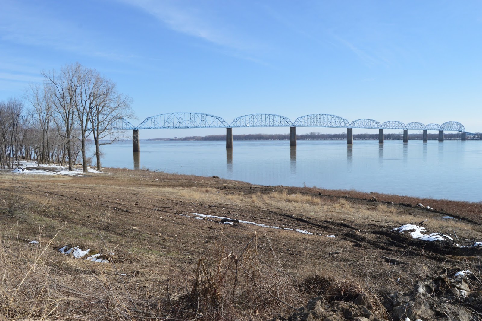
| 20150302 0078 3:11pm. downstream side from Illinois river bank |
Last March [2015] I was in Kentucky and, when I came back home, instead of zooming past Paducah on I-24 as I normally do, I visited the downtown and then went into Illinois on US-45. The approach to the bridge gave me a clue that crossing this bridge might be "exciting." It was a rather narrow road on a high embankment, and we passed a sign warning motorcycles that it had a steel deck and another sign posting a 25 MPH speed limit. I normally don't creep-out on a bridge, but this one was creepy because it was so narrow and a dump truck was on my tail. The steel deck was jerking the tires of my minivan back and forth. I got my speed to up over 40 MPH, and the truck driver was still obviously unhappy with me, but that was as fast as I was going. This bridge is nicknamed the Hummer Bridge, and your tires do make a humming sound on the steel grate deck.
 |
Hughes Market and Meat Processing Inc posted
Did you know, the Brookport Bridge, The Brookport Bridge was constructed in 1929, replacing an older ferry crossing between the towns of Brookport and Paducah. It has an enormous simple span, measuring 716 feet and 3/8 of an inch. It is one of the longest simple truss spans in existence. One of the unusual details of this bridge is that the largest span is at the southern end of the bridge, not in the middle. From north to south, the bridge includes three Warren pony truss bridges, with a sharp bend in the roadway; a Parker through truss; nine polygonal Warren through truss spans which are subdivided; four Warren deck truss spans, followed by a series of short steel stringer spans. While the roadway maintains the same narrow 19.7 foot width, the 716 foot span is notably wider (distance between trusses) so on this span there is a gap between the edge of the roadway and the truss lines. The trusses of the bridge are incredibly deep (tall) due to the span length, and the extra width probably helps keep the bridge from becoming top heavy and tipping over in high winds. Another unusual detail is that toward the southern end of the truss, the roadway grade suddenly angles downward (from level grade to -5% grade) to match the grade of the southern approach spans. The truss was designed to accommodate this, and the bottom chord has a matching change in angle at this point. At the northern end of the bridge, there is a similar change in grade, but it occurs at a pier point, not inside a truss, and the grade change is only to 2.44%. Fred Rehlmeyer: the 716 ft. Southern most span is wider than the rest of bridge because this was originally a toll bridge and the toll booth was in middle of this span and in between the north and southbound lanes. Does anybody have photos of the toll booth? [I'm guessing it is wider for structural reasons, and they took advantage of that width to install the toll booth.] Roxie Tempus: It seems that it has held up over the years better than the I-24 bridge just down the river! James Stark: Roxie Tempus Hydrogen embrittlement issues with the steel rods, plus a lot more traffic… |
 |
Philip Durbin commented on the above post, cropped
Just went over it last Sunday. |
The main navigation span on the south side of the river is 716', just 4' less than the main span of the
Metropolis Bridge. The is an 514' auxiliary navigation span in the middle of the river. The remaining spans are 396'. These bridges used simple truss spans instead of the more typical cantilever spans of the time for long distances because of the soil conditions in this area. "The 716 foot span has some additional unusual details. While the roadway maintains the same narrow 19.7 foot width, the 716 foot span is notably wider (distance between trusses) so on this span there is a gap between the edge of the roadway and the truss lines. The reason for this is presumably for stability reasons. The trusses of the bridge are incredibly deep (tall) due to the span length, and the extra width probably helps keep the bridge from becoming top heavy and tipping over in high winds. Another unusual detail is that toward the southern end of the truss, the roadway grade suddenly angles downward (from level grade to -5% grade) to match the grade of the southern approach spans. The truss was designed to accommodate this, and the bottom chord has a matching change in angle at this point. At the northern end of the bridge, there is a similar change in grade, but it occurs at a pier point, not inside a truss, and the grade change is only to 2.44%." [HistoricBridges] As I learned when researching the Metropolis Bridge, the steamship industry convinced the government to require a 700' span for navigation. They felt that was long enough to make building a bridge impossible.
 |
Craig Rhodes posted
The Brookport Bridge from another viewpoint by Glenn Hall. |
As I expected, my wife was not willing to drive back across the bridge while I took pictures. This is no big deal because
Bridge Hunter has lots of "on bridge" pictures. In fact, there are several videos from cars crossing this bridge. The
first link I found is one of the better ones if you skip the first minute. It does catch the hum of the tires on a steel deck. With a truck on my tail the whole way, the trip seemed to be a long one. The length of the bridge reminded me that when the Ohio River meets the Mississippi River, the Ohio River is bigger. (According to Bridge Hunter, the length is a little over a mile and the longest span is 711 feet. According to
Historic Bridges, it is 716 feet.) Looking at a map, there are only 4 road bridges and a ferry across the Ohio along the entire Illinois border. From East to West:
- Old Shawneetown: IL-13/KY-56
- Cave-in-Rock Ferry: IL-1/KY-91
- Brookport: US-45
- I-24
- Cairo: US-62
 |
| 20150730 3673 |
The gates in the river wall were open, so I was able to access the riverbank. And they keep the riverbank clear of trees so I was able to get a good view of the bridge without having to get close to the river. I don't know why they keep the bank clear, but I'm glad they do. It is not to allow the water to flow better during floods because they left the trees further upstream.
Note how the roadway is
still climbing up on the shore side of the span.
In this closeup of the six southern through trusses, you can see that the leftmost span is a little larger, 514 feet, than the normal length of 396 feet. I wonder if this longer span was because of the economics of pier placement or the need for a secondary navigation channel. Historic Bridges has diagrammed
the details of the spans. We learn that the "kink" in the 716 foot span is a 5% grade.
 |
| 20150730 3670 12:13pm |
I made the trip from Kentucky again on July 30
th. Since we had a very rainy Summer, I got off I-24 onto US-45 to revisit the river. The river level was somewhat higher than the above March 2015 level. But as you can see from all of the driftwood left on the river bank, it had been a lot higher. The graph below confirms this. The action level is 32 feet.
I include a closeup of the near spans from the July set of pictures because the contrast with the sky was better and it is easier to analyze the truss design.
I include a closeup from March because you can see various water level marks on the pier. Also, the reflection of the pier in the water indicates the river can be quite still.
Update:
The Illinois Flickr Album contains
a nice picture of this bridge.
 |
David Cantrell posted
Brookport, IL Aerial View 1937 Flood National Archives Airscapes Collection |
I normally don't save videos that show duplicate what you can easily see with Google Map's street view, but I've never seen this much traffic on the bridge. I guess some people do use it. Or is this a group of people that met to drive over the bridge together. But there were a few cars going in the other direction as well. Sometimes when I crossed the bridge, I did not meet any traffic.
5:55 video of the bridge being inspected provides some detailed views


 Note how the roadway is still climbing up on the shore side of the span.
 In this closeup of the six southern through trusses, you can see that the leftmost span is a little larger, 514 feet, than the normal length of 396 feet. I wonder if this longer span was because of the economics of pier placement or the need for a secondary navigation channel. Historic Bridges has diagrammed the details of the spans. We learn that the "kink" in the 716 foot span is a 5% grade.
 I include a closeup of the near spans from the July set of pictures because the contrast with the sky was better and it is easier to analyze the truss design.
 I include a closeup from March because you can see various water level marks on the pier. Also, the reflection of the pier in the water indicates the river can be quite still.


No comments:
Post a Comment