Tuesday, July 22, 2025

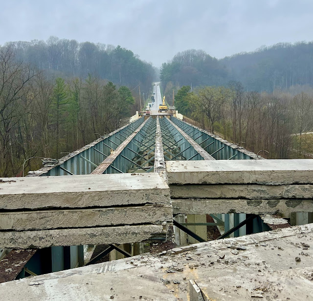
1898+1902,2009Trail/St. J. & L.C. Bridges over Missisquoi River in Swanton, VT

2009: (Archived Bridge Hunter; Bridge Hunter; no Historic Bridges; Satellite)
1902: (Archived Bridge HunterBridge Hunter; Satellite) The West Milton Bridge provided the trusses for the trail bridge.

While studying the depot in Swanton, I learned about these bridges.

1898 History: "Built 1898; Bypassed 1968; Destroyed by arson in 1987" [BridgeHunter_1898]
Truss History: "Built 1902; dismantled & moved 2003; Reconstructed as pedestrian bridge in 2009" [BridgeHunter_2009]

Photo via SwantonHistoricalSociety

A truss bridge was moved here to replace the covered bridge, and it became the trailhead for the Lamoille Valley Rail Trail.
Street View, Jun 2012

Rock Chevalier, May 2025

Tiffany Miller, Jun 2019

Dawn Frazier, Aug 2018

 The trusses appear to be pin connected.
Jackie, Aug 2024

It appears that they covered the trusses on the inside as well. That is unusual.
Scanned by Robert Stephenson via BridgeHutner_2009

The trusses before they were moved from West Milton Bridge.
NRHP nomination photo from 1985 via BridgeHunter_1902

The pier of the West Milton Bridge still exists.
Street View, Nov 2023


1957+2012 RI-24 and 1899-2007 NYNH&H Bridges over Sakonnet River at Tiverton, RI

1957: (Archived Bridge Hunter; Bridge Hunter; no Historic Bridges; Satellite, they left the piers)
2012: (Satellite)
HYNH&H: (Archived Bridge Hunter; Bridge Hunter; no Historic Bridges; Satellite)

Bridges Now and Then posted
Thursday April 12, 2018, Tiverton, RI. Sections of the old Sakonnet River Bridge being dismantled. (The Providence Journal)

The piers are from the 1957 truss bridge. It looks like the 2012 bridge is a box-girder bridge.
Street View, Jul 2021

The approaches use concrete girders.
Street View, Jul 2023

BridgeHunter_NYNH&H
"Built 1899; Closed 1980 after being damaged by an overweight train; Hit by boat 1988; Demolished 2006-7"

Photo by Marc N. Belanger via BridgeHunter_NYNH&H

RIDOT via ArchivedBridgeHunter_1957
2,989' (911m) long with a main span of 375' (114m)

2005 photo by Marc N. Belanger via BridgeHunter_1957, at webpage resolution
"Built 1957; rehabilitated 1990; Replaced 2012; Demolished 2018"
BridgeHunter calls it a through truss. 

RIDOT via BridgeHunter_1957

BridgeHunter_1957, License: Creative Commons Attribution-Share-Alike (CC BY-SA): Providence Public Library

Monday, July 21, 2025

2012 Margaret Hunt Hill and 1930 UP/MoPac/Texas & Pacific Bridges over Trinity River in Dallas, TX

Margaret: (Archived Bridge Hunter; Bridge Hunter; Satellite)

Street View, Mar 2025

Because the bridges go levee to levee over the floodplain, they have long approaches.
Street View, Mar 2025

Charles Davis Photography posted two photos with the comment: "Margaret and Friends..."
Charles Davis Photography shared with the comment:
Margaret Hunt Hill Bridge 
And the Pacific Railroad Bridge
Dallas TX
1

2

The arches on the right belong to the Margaret McDermott Bridge. And that is a serious power-line pole on the far right.
Street View, Jan 2025

Jesse Berube via HistoricBridges

Sunday, July 20, 2025

1879+1900 KCS/GM&O Bridges over Missouri River at Glasgow, MO

1900: (Archived Bridge Hunter, broken link; Bridge HunterHistoric Bridges; Satellite)

The truss bridge no longer exists for the road.
Street View, Jun 2008

BridgeHunter_1879

BridgeHunter_1879

2016 Photo by John Marvig via BridgeHunter_1900

I presume the approach deck trusses are newer because they are not pin-connected like the through trusses.
Street View, Jan 2016

2016 Photo by John Marvig via BridgeHunter_1900

2016 Photo by John Marvig via BridgeHunter_1900

MoDOT photo via HistoricBridges

"Two deck trusses were replaced in 1993 by modern beams due to flooding." [Historic Bridges]
Street View, Jul 2024

This is the post that motivated these notes.
Mike Heying posted
River is back to a calm after the MR340...

Saturday, July 19, 2025

1954 320mw Fort Randall Dam (Lake Francis Case) on Missouri River at Pickstown, SD

(Satellite)

The spillway is on the right, the powerhouse is right of center, and earthfillgated  counties out-of-frame to the left.
Street View, Aug 2024

USACE

This is the spillway. This is the outlet works. The outlet works are connected to the same intake structure that the powerhouse uses. It disturbs me that a USACE web page would confuse a spillway with an outlet works. This photo is of the outlet works, not the spillway.
USACE
"During normal operations, USACE releases up to 44,500 cubic feet of water per second through the powerhouse. One cubic foot of water, or cfs, is equal to 7.5 gallons. The outlet tunnel can release an additional 128,000 cfs. The spillway was designed to additionally release up to 633,000 cfs. For perspective, the largest release of water from Fort Randall Dam as a result of flooding was a combined 160,000 cfs from the powerhouse and spillway in 2011. It is important to understand that the dam is designed to release up to 805,500 cfs when necessary and that dams do not eliminate flood risk."
[128kcfs is more water than many gated spillways can release. I wonder what the downstream river can handle without flooding.]

This is what the spillway looks like.
USACE
"Omaha District completed several risk reduction actions at Fort Randall Dam after the flooding of 2011.  These include installation of additional instrumentation to enhance foundation monitoring. Numerous repairs have also been made to the spillway to improve its resiliency during future flood events." [This sounds like another USACE spillway that did not perform as intended when it had to be used.]

I could not find statistics about the dam on the USACE web page such as length, elevations and conservation & flood pool capacities. Nor on any other page on the internet. But then I did find this.
Donald Regan, Mar 2016

Digitally zoomed

lewis-clark

It is a shame that they don't provide enough resolution so that we can easily read this graphic.
USACE

This was the post that motivated these notes.
2:11 video
he Fort Randall Dam is taking on a massive modernization effort as the Major Unit Rehabilitation Project is officially in motion!
Components for the first of eight massive new units began arriving on-site in late June 2025. Standing more than three stories tall, each unit is a towering feat of engineering.
Over the next eight years, all existing units will be carefully removed and replaced, marking one of the largest upgrades in the dam’s history.

1924,1961,1995-1924 KY-24 Closed/Chenault Bridge over Dix River near Danville, KY

(Archived Bridge Hunter; Bridge Hunter; no Historic Bridges; Satellite)

Street View, Jul 2018

Winds Aloft, Nov 2021

Bridges & Tunnels posted
The Chenault Bridge, a 1924 Baltimore through truss over the Dix River in Kentucky, once linked Boyle and Garrard counties via State Route 34 and was featured in the film Lawn Dogs. It remained in local use until its closure in 2015 due to deck deterioration.

James McCray photo via BridgeHunter

4:23 video @ 3:40
"This  bridge  was  constructed  in  1924  by  the  F.K.  Ketler  Company  of  Chicago,  Illinois.  They  started  operations  in  1924  so  this  must  have  been  one  of  their  first  projects.  The  company  is  still  in  business  today.  The  bridge  is  547  feet  long  and  spans  the  Dix  River.  It  was  rehabbed  in  1961  and  closed  to  all  traffic  in  2016  due  to  serious  issues  with  the  deck.  When  it  was  open  it  served  about  630  vehicles  a  day  but  now  it  just  sits  abandoned.  Another  piece  of  history  slowly  fading  away."

Friday, July 18, 2025

I-471 Daniel Carter Beard (Big Mac) Bridge damaged by playground fire at Cincinnati, OH

See Big Mac Bridge for the regular description of the bridge. These notes concentrate on the destruction of the north approach of the southbound lanes by a playground fire.

WLST posted three photos with the comment: "PHOTOS: Demolition work continues Monday as crews work to make repairs on Big Mac Bridge. (📷: ODOT)."
[As some comments pointed out, the beams did not melt; they buckled because they became too weak to hold their load. It takes significantly less heat to weaken steel than it does to melt it.]
Bridges & Tunnels shared with the comment: "Demolition work is under way on the Daniel Carter Beard “Big Mac” Bridge."
1

2

3

The Google Maps label for the playground indicates that it is temporarily closed. Here are some before photos. It was built with a lot of plastic. And I wonder how flammable the mat material is.
Brett Stakelin, Jun 2024

It looks like they were lucky that the northbound lanes were not also destroyed.
Brett Stakelin, Jun 2024

Brett Stakelin, Jun 2024

Brett Stakelin, Jun 2024

Jan 19, 2025: the 7 new girders have been delivered and installed.
9:27 video @ 0:05

A clip from an ODOT video.
@ 2:01