Showing posts with label canalME. Show all posts

Sunday, February 16, 2025

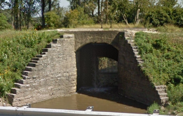
M&E Feeder Canal and St. Ate Diversion Dam on Great Miami River near Port jefferson, OH

Dam: (Satellite, it has been washed out)
Feeder Canal Headwaters: (Satellite)
Feeder Canal: (Satellite, the algae on the stagnant water makes it easy to identify.)


I discovered this feeder canal while studying the B&O bridge over the Great Miami River and River Road.
Satellite

From that Canal Feeder Park, I followed the canal upstream until I found the diversion dam.
1913/34 Sidney Quad @ 62,500

Some of this feeder canal is now part of the Canal Feeder Trail.
Christy Leigh Wilkins, Dec 2022

In the Lockington area, there is more left of this feeder canal than there is of the original canal. I marked where the canal leaves the Great Miami River Valley and heads west to provide water for the five locks in Lockington.
Satellite

As the canal went downstream along the river from the diversion dam, it climbed a bluff so that it would be on top of the bluff where it then heads west to Lockington.
1914/31 Troy Quad @ 62,500

Friday, November 22, 2024

Miami & Erie Canal Aqueduct over Sixmile Creek

(Satellite)

Street View, Jul 2023

Gray Geisel posted
Six Mile Creek Aqueduct / Miami + Erie canal  - restored 2022
Auglaize County, Ohio / USA
Photo taken 7 -Aug - 2024
The falling water is overflow from the canal.

Steve Lesh commented on Gray's post
Oct 2015, been all up and down the Canal, such a history🤩

Nick Feathers provided a 0:17 video on Gray's post

It didn't look like it was in too bad of shape before the 2022 restoration. Then I read below that it was damaged by floods in 2018 and 2019.
Street View, Sep 2015

We need a view between 2019 and 2022 to see why restoration work was needed.
"In 2018 and 2019, the aqueduct suffered a series of failures due to deterioration and exceptional rain events. With assistance from local and state agencies, the Ohio Department of Natural Resources prevented complete loss of the structure and successfully restored the aqueduct." [OhioDNR]
I forgot that an aqueduct can be ruined in just a day or two because of a flood. That is what happened to the Morris Nettle Creek Aqueduct on the Illinois & Michigan Canal in April 2013. I'm glad to see that Ohio did a good restoration in just a few years. That is certainly better than what Illinois has done for their canal even though it is part of a National Heritage Trail.

Saturday, November 16, 2024

Miami & Erie Canal Aqueduct over Mad River in Dayton, OH

(Satellite, the ruins of the eastern abutment)

The ruins of the east abutment of the Miami & Erie Canal Aqueduct.
Trail View, Aug 2016

Jon Zee posted seven images with the comment: "Miami Erie canal in western Ohio.  Mad River Aqueduct- site near Dayton Children’s Hospital. The new addition covers canal bed.  The only part left is the south abutment across the MadRiver on the bike path (easy access)"
1

2

3

4

5

6

7

Jon Zee posted two images with the comment: "Mad River Aqueduct Miami Ans Erie Canal."
1
Timothy Payton Earick: Interesting. I was unaware that a lock existed there too.
Cool

2

Jon Zee posted six images, this is the only new one.

1906/35 Dayton Quad @ 62,500


Friday, November 15, 2024

1854-1913 Five Miami & Erie Canal Locks in Lockington, OH

(Satellite, 204 photos)

These five locks raised the Miami & Erie Canal 67' (20.4m) to the highest point on the canal between Cincinnati and Toledo. Since this was the summit of the canal, a feeder canal was built starting from a little northeast of Port Jefferson, OH.

These are the top two locks.
Street View, Sep 2024

This clearing allows us to not only see those top two locks, but part of the hill that the canal had to climb. The upper lock is obvious on the right side of the view. We can see only part of the far wall of the lower lock on the left side.
Street View, Sep 2024

Jim Kerste, May 2023

This photo and the above plaque clued me into the fact that there are more than just the two locks we can see from the streets.
Nathan Brown, Apr 2022

The three lower locks are lost in the shadows in the current (Nov 2024) satellite map. So I fired up Google Earth. We can clearly see all five locks in this image.
Google Earth, Nov 2021

The cartographer omitted the uppermost lock.
1914/31 Tory Quad @ 62,500

Sunday, September 8, 2024

Tytus Avenue Lift Bridge over Miami & Erie Canal in Middletown, OH

(Satellite, Verity Parkway is built on the canal's right-of-way.)

Preserve Madison Township posted
Postcard featuring the Tytus Avenue, Middletown, Ohio, lift bridge. Postcard is dated circa 1900. The bridge crosses the Miami and Erie Canal at Tytus Avenue and is designed to lift to allow canal boats to safely pass under.
George Crout used this image in the program titled "Miami-Erie Canal at Middletown" as slide No. 18 of 55. Text from the program reads: Take a closer look at a hoist bridge which once stood over the Canal between Main St. and Tytus. It was cut down and installed over the Hydraulic, being the one you crossed on the way to the Museum.
The Miami and Erie Canal stretched from Cincinnati to Toledo and created a water route from the Ohio River to Lake Erie. Groundbreaking for the canal took place in Middletown on July 21, 1825. In 1845, work on the canal was completed. The rise of railroads eventually diminished the value of the canal, and it was officially closed on November 2, 1929, again in Middletown. With the canal’s closing, sections of the canal were filled in and converted into streets, while other sections became abandoned. In Middletown, what was once the canal became Verity Parkway. Middletown was also home to the Middletown Hydraulic Canal – a local canal used to supply water to Middletown’s early paper mills and industry, and the Warren County Canal – a canal that connected the Miami and Erie Canal to Lebanon. In addition to the Miami and Erie Canal, Ohio’s other prominent canal was the Ohio and Erie Canal constructed in the eastern part of the state.
Douglas Butler shared
Tytus Avenue Lift Bridge was removed Middletown, OH.

1908 Miamisburg Quad @ 62,500

Owen "Big O" Bowen, Apr 2024

"The Canal Museum was erected in 1982 as a replica of a lock tender's house." [MiddletownHistoricalSociety]

Middletown Historical Society posted
Tytus Avenue Bridge, Middletown Ohio, c. 1900
Publisher Fay, John T., druggest, Middletown; Norwood Souvenir Co., Cincinnati, O.
Date c. 1900
Description: The Tytus Avenue bridge was one of several that crossed the Miami-Erie Canal. Since this is an electric hoist bridge, it must have been constructed near the end of the canal era. It was located on Tytus over what today is Verity Parkway, but was then the canal. Part of this bridge was moved to the Hydraulic Canal, and now provides a walkway to the Middletown Historical Society's Canal Museum. This is slide 39 of 80 used in the slide program titled "Canal Days - Miami-Erie Canal." The text reads: This type of bridge was at Tytus and the Canal, and known as a lift bridge, with the mechanism shown, lifting the whole bed of the bridge.
Jeff Muohio: Can somebody tell me how the hydraulic canal got its name?
Middletown Historical Society: Jeff Muohio In 1852, the Middletown Hydraulic Canal was an extension of the Miami and Erie Canal that supplied water and boat access to Middletown’s paper mills and industry. It was originally built and operated by the Middletown Hydraulic Company. When finished, the canal was 2.5 miles long. When the canal was built, it supplied water to power Middletown and its various industrial needs. The construction of the Hydraulic helped give rise to Middletown’s prominent paper industry. Eventually, electricity replaced the need for waterpower, diminishing the value of the hydraulic canal. In 1993, the state dam that provided water to the hydraulic canal broke, depriving it of water. At the time, the Sorg Paper Company and Aeronca were still using the canal for cooling purposes, while the City of Middletown was using it as a storm sewer. As of 2020, vestiges of the Hydraulic Canal still existed and were used for various sewer and wastewater purposes.
Douglas Butler shared
Tytus Avenue Lift Bridge is located in Middletown, OH credit to Middletown Historic Society.

Tuesday, August 13, 2024

Miami & Erie Canal, Covered Bridge and 1847 Flour Mill in St. Marys, OH

Lock #13: (Satellite, 66 photos)
Display Boat: (Satellite, 76 photos)
Covered Bridge: (Satellite, 5 photos)
Flour Mill: (Satellite)
Aqueduct: (Satellite, I noticed on the topo map that the canal crossed the river, so I looked for an aqueduct.)

Julie Baumgartner posted
Postcard, St. Mary's, Ohio, Old Lock on Miami Canal, postmarked Saint Marys, Ohio, Nov. 5, 2:30 PM, 1908.  Postcard sent to Mrs. L. D. Hellwarth, Celina, O. Back of postcard in comments.

Street View, Oct 2013

Notice the pristine concrete walls in the lock. It was built in the 21st, not the 19th, Century,
Street View, Jun 2009

The turn in the canal channel is consistent with the photo at the top. That photo was probably taken from the High Street Bridge.
Satellite

A topo map shows that they have restored a remnant of the original canal channel.
1911/42 Spencerville Quad @ 24,000

Justin Beebe, May 2021

The replica canal boat was built in 1990. [plaque]
Eric Salas, Jul 2021

Gerry is a little lost, lock #44 has to be quite a ways further south. I'm saving this for future reference.
Gerry Laureys, Sep 2016

Street View, Jun 2023

Debra Elliott, Jan 2023

K Lego, Mar 2024

Note in the Oct 2013 street view near the top of these notes just after the historic lock photo that there is an old building in the right background. That was a mill.
Street View, Sep 2015

My first reaction was that the restoration gutted the flour mill. Actually, it removed the additions and renovated the original 1847 building. [plaque1, plaque2]
Street View, Nov 2021

Calvin Schubert, Dec 2023, cropped

Sunday, February 7, 2021

Miami & Erie Canal in Ohio Overview


This canal was on the west side of the state. The Ohio and Erie Canal was on the east side of the state.

This map shows that Ohio had two canals connecting Lake Erie with the Ohio River. This north/south orientation for transportation and growth is why the early charters I read about when studying the Pennsy's Panhandle route had a north/south orientation. But the superior technology of railroads allowed them to connect the Midwest directly with the east coast making canals obsolete and changing the orientation of transportation across Ohio to be east/west. As can be seen on the map, the western canal was Miami & Erie. The reason for the name is that it was dug through the Miami Valley and the name Ohio & Erie was already used. Studying a map, I see the Great Miami River went north from the Ohio River up through Dayton, OH.

Erie Canal On Us Map [The link broke after I wrote the draft in 2018.]

ohio-voyager
Bobbie Flinders Wilson posted
Prior to Railroads and Interstate Highways...
The "Ohio Canal System", built between 1825 and 1845 at a cost of more than $8 million (equal to $275 million today), included the following two primary canals, plus five feeder canals:  
Two Primary Canals:  1) the "Miami & Erie Canal"--from Lake Erie at Toledo to the Ohio River at Cincinnati; 2) the "Ohio & Erie Canal"--from Lake Erie at the mouth of the Wabash River at Cleveland to the Ohio River near Portsmouth, Five Feeder Canals:  1) the "Pennsylvania & Ohio Canal"; 2) the "Sandy & Beaver Canal"; 3) the "Hocking Canal"; 4) the "Wabash & Erie Canal"; and 5) the "Cincinnati & Whitewater Canal", plus several smaller short feeders.  
The following map shows the routes of the entire "Ohio Canal System", plus the location of several "Canal Reservoirs" throughout the state
Lew Carbone: This map ignores the Milan Canal, in North-Central Ohio. This was a deep-water canal that could accommodate lake-going ships. Along with the Erie Canal, it allowed Northern Ohio farmers to connect to markets in New York City.

The survey for the canal was made in 1822. Construction was recommended and legislation passed in 1825. Construction started July 25, 1825 near Middletown. (It didn't start on July 4 as was the custom back then because the Ohio dignitaries were starting the Ohio & Erie Canal that day.) The section from Cincinnati to Dayton was completed in 1829 and the whole canal was finished in 1845, three years before the Illinois & Michigan Canal was operational. The trip between Cincinnati to Dayton took a day, and two more days were needed to reach Toledo. The peak year was 1851 when about 400 boats generated $351,897 revenue for the canal. The canal closed in 1913 when a massive flood significantly damaged many facilities. [NewBremen, DaytonDailyNews]
The Miami-Erie Canal utilized 105 locks to raise and lower the canal boats along the 250-mile waterway.  Loramie Summit, 21 miles in length, was the high point of the canal - 521 feet above the Ohio River and 395 feet above Lake Erie.  The average canal boat was 78 feet long, 14 feet-10 inches wide, and cost approximately $2,100.  The Ohio canals were dug by hand with picks and shovels.  Occasionally, teams of horses and oxen were used to power slip-scoops and pull wagons. The Deep Cut, 6,600 feet in length, was the deepest excavation made along the Miami-Erie Canal, and ranged from five to 52 feet deep.  Three man-made lakes, Grand Lake St. Marys, Lake Loramie, and Indian Lake, along with the Miami, Mad, St. Marys and Auglaize Rivers served as the primary sources of water for the canal. [NewBremenHistory]
There were 19 aqueducts and the length of the canal was 248.8 miles. [NewBremen]
The canal commissioners estimated that the Ohio and Erie Canal would cost approximately 2.3 million dollars, while the Miami and Erie would cost 2.9 million. Once construction was completed, the canals combined actually cost 41 million dollars, 25 million dollars of which was interest on loans.[So cost overruns are not a recent invention.]...Usually canals in the northern half of the state were drained dry from November to April. During the winter months, workers would repair any damage that occurred during the earlier part of the year. In southern Ohio, canals generally stayed open the entire year. The difficulties Ohioans faced with the canals paled in comparison to the advantages that they garnered. Most importantly, the cost to ship goods from the East Coast to Ohio and vice versa declined tremendously from 125 dollars per ton of goods to twenty-five dollars per ton of goods....There is a short stretch in the Muskingum Valley near Zanesville still in operation today. [OhioHistoryCentral]

I saved the following two images from vanwert.biz to help me plan my next trip between Columbus and Chicago. ODOT has a Byway Page for this canal. I have already made a trip that visited some canal related facilities. As I write notes using the photos I took, I will use the "canalME" label on those notes.

1
2


This video is actually about the engineering of towpaths, but it uses the M&E Canal as his example.
18:20 video @ 1:15