Showing posts with label wwDamWicket. Show all posts

Wednesday, May 3, 2023

LaGrange Lock and Dam on Illinois River

(John A. Weeks III; Satellite)

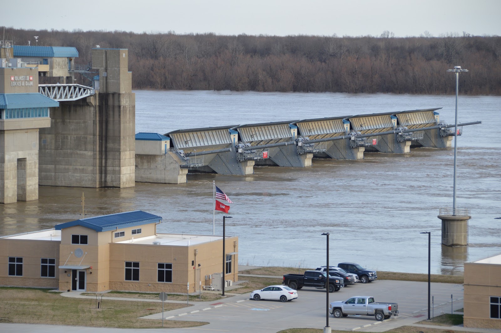
This is the last dam before the river joins the Mississippi 80 miles further downstream.

This aerial photo shows the dam with the wicket gates in the down position. The other wicket-gate dam on the Illinois River is the Peoria Lock and Dam. Hopefully, those notes explain that the gates are down when the river level is high and that they are raised when the river level is low.
USACE

A satellite image caught the dam with the gates in the raised position. It also caught a double locking operation in progress.
Satellite

Zooming in, we see the tender that raises and lowers the gates. It is moored by the Tainter gate that is used to control the river level.
Satellite

An aerial view of a double locking and rthe aised wicket gates.
ICE

JohnWeeks
 
Tracy Brasel posted
Lagrange locks
Comments on Tracy's post

Kyle Perry commented on Tracy's post
Now that’s a wicket lifter
 
Typically, in the Spring the river runs high and the wicket gates are down.
Google Earth, Mar 2005

And in the late Summer the river is low and the gates are up.
Google Earth, Sep 2005

And some years it floods and putting the gates down does not provide enough flow.
Google Earth, Apr 1998

USACE, RI District posted
The countdown is on! The 2023 Consolidated Lock Closures on the Illinois Waterway are scheduled to begin in one month! On June 1, the locks at Brandon Road, Dresden Island and Marseilles will fully close to river traffic for much needed maintenance.
Click here to find out more information about the closures and the timeline:   https://www.mvr.usace.army.mil/Missions/Navigation/Navigation-Status/
(Note: This photo was taken at LaGrange Lock and Dam during the 2020 Illinois Waterway Consolidated Closures.)
Fort Loudoun Lock shared
If you are planning a trip that includes traveling up the Illinois River/Illinois Waterway in the near future, then please check the consolidated lock closures that are set to commence on June 1st in just one month!

I was surprised that they never did get rid of all of the water from the lock. When I see photos of the dewatered locks on the Upper Mississippi or the Soo Locks, the bottom of the lock is dry. But then I remembered that this lock is open 365 days of the year. That is, it is not regularly dewatered during the Winter season.
2:58 video @ 0:52

enr [paycount], photo courtesy of AECOM Shimmick
The project cost $117m.
"Heavy equipment within the tight footprint of the riverside lock and dam included a 300-ton crane on the land side, a 300-ton crane upstream and a 300-ton crane downstream of the bulkheads and the lock. A 150-ton crane was located on a barge outside of the riverside wall and two 60-ton cranes down in the chamber. On the land wall there were two 130-ton cranes and another 60-ton crane. These cranes were used to place the lock armor as well as new concrete for the lock walls, which the cranes placed using buckets."

Since this lock is next to a wicket dam, you know that the river level varies a lot during the year. That is, the lock getting flooded is the norm rather than the exception.
Specifically, "the LaGrange Lock and Dam is unique. When the Illinois River rises above normal pool elevation, the entire lock and dam goes underwater. This happens regularly and can sometimes go underwater to a depth of 14 FT, where towboat traffic can navigate over the top." This is why this dam uses hydraulic, instead of electric, equipment to operate the gates and Tainter valves. [Brennan]

enr [paycount], photo courtesy of AECOM Shimmick
"The 1939 lock and dam’s concrete had deteriorated so much that grass was growing through it."

jfbrennan
They used several 10" electrical pumps to dewater the lock chamber.

While Shimmik resurfaced the concrete on the interior, Brennan resurfaced the exterior. Since the exterior wall is still under water when the chamber is dewatered, they designed custom box-type cofferdams to facilitate the replacement of 18" of wall concrete and steel armor plating.
jfbrennan

Note the seals on three edges of this Tainter gate. This gate is one of the four valves that control the flow in to and out of the chamber.
jfbrennan

Dam construction is one of the specialities of Brennan.

This content was copied from a redundant La Grange Dam post.

Satellite
Pages 2 and 3 of the March 30, 2017 USDA Grain Transportation report (source link) indicates the locks will be closed 10 hours each day between June and August. Fortunately, this is a low season for soybeans and corn shipments during this period.

Note that the report indicates that about a third of the grain for Lock 26 on the Mississippi comes from the Illinois Waterway and about two-thirds comes from the upper Mississippi River.

This is a wicket dam and this satellite image indicates the river flow is low because the gates are up. I assume the barge parked next to the Tainter gate is the tender that is used to raise and lower the gates.

One of John's photos shows the gates were also up when he visited. And it includes a view of the tender.
John A. Weeks III

Satellite
I checked Bing's satellite image to see if the gates were down. They were not. That image was also taken during low river levels.

The additional barges and towboats are of interest. Given all of the pickup trucks along the lock entrance (workers), it appears they are doing some maintenance. It just occurred to me that they don't have to wait until night for "off hours" because towboat crews work around the clock. They can do maintenance during the day without changing the impact on the barge traffic.


Sunday, February 6, 2022

1928-1976 Lock & Dam #46 on the Ohio River at Owensboro, KY

(Satellite, the lock was along today's English Park between Hanning Lane and Woodford Ave.)

The Newburgh L&D made this wicket dam and L&D #47 obsolete.

Michael Gore posted three images with the comment: "With all the ongoing icy river posts and photos, I remembered a childhood winter in 1970. The M/V RAYMOND E. SALVATI (later OWEN CHILDRESS, MARGARET M. IGERT, JILL MARIE, RIVER HAWK, and finally DAVE CATHORALL) was the first towboat I ever rode on.  L&D 46 (Owensboro, KY) Lockmaster Peter B. English sent me these photos of the SALVATI breaking ice above the dam. My father and I went down and watched from on top the bank for a long time that day until we could stand the cold no longer. If I remember correctly, Capt. Lonnie White was on watch. I will post more about this very special boat for me another time."
[English Park in the satellite link above was named after Peter English, the last lockmaster for #46.]
1

2

3


Four photos from: Christina Clary on behalf of Kentucky Room Daviess County Public Library. "Lock & Dam 46." Clio: Your Guide to History. May 13, 2020. Accessed February 6, 2022https://www.theclio.com/entry/103327
1

2

3
4

1952 Owensboro (East & West) Quads @ 1:24,000

Postcard

Tuesday, March 17, 2020

My Olmsted Dam Photos and Support Equipment

(Satellite)

After checking out the TVA dams of Wheeler, Wilson and Pickwick, I debated weather to see the Kentucky or Olmsted Dams. Olmsted had been on my todo list since it went operational. But I've never seen the Kentucky Dam with a heavy flow of water through it. In case the road across the Kentucky Dam was closed because of the heavy flow, I choose Olmsted Dam.

I've already have written an overview of the Olmsted Dam.

Actually, I still haven't seen much of the Olmsted Dam because most of it was under water! I was not surprised that the Tennessee River was high because there had been a lot of rain and flooding in the Southeast. But I had not heard much about rain in the Ohio Valley. So is the Ohio high here in Feb 2020 because the Tennessee had dumped that much water into it or was there a lot of water coming from the Ohio Valley as well?
20200219 1471


Some overview shots from the sidewalk at the visitor center from upstream (left) to downstream. 


Using the magic of a zooms lens, I took some closer shots.


I want to visit again to see what the dam looks like during a normal river flow. But those two concrete "poles" sticking up in the water is an extra motivation to see what is under all of this water.


The construction "camp" is still intact.

Most of the big equipment is gone including the very large gantry crane that took the modules down a ramp into the river.


But a Manitowoc 16000 still remains.


And there was also a barge crane parked on the opposite side of the river a little upstream from the dam. I don't know if that was a left over from this project or not. Nor do I know if the above crane is the 60' ringer that the USACE sold in Dec 2019. That is, has this crane been painted, but not moved, by its new owner.


The USACE still has some of its equipment parked at the dam. I learned that this equipment is dedicated to operating the dam.

The towboat was the St. James, the barge crane was the Roger R. Henry and the spud barge with the  hydraulic boom crane and excavator-like hinged boom was the Keen.

I'm glad I looked up Keen because I had no idea that Olmsted used 140 wicket gates. I thought wicket gates were obsolete! Especially for a multi-billion dollar dam. That explains why we see a superstructure for only five Tainter gates. Keen will remain parked at this dam because it is custom built to raise and lower the wicket gates.
USACE Keen Fact Sheet
(Click on the following to play a USACE video about the wicket lifter.

dvidshub
[An example of a wicket gate in the raised position. This is a screenshot. The video at the dvidshub link is the same as the embedded video above.]

Fact Sheet
From the plans, it looks like a major mission of this crane barge is dredging because they show it with a clamshell bucket.
Is this the worlds largest power washer?
USACE Olmsted Washdown Barge Fact Sheet
Articulating water boom has horizontal reach of 93 feet and vertical reaches of 106 feet above deck and 55 feet below the waterline. The boom is provided with a self-contained, electric-hydraulic power pack powered by a 20 HP, 460 VAC motor. The boom may be controlled locally by hydraulic valves or remotely by a radio-operated control box. A control monitor, in the control room, displays real time pictures of the boom position and numerical readout of boom azimuth and height.
[Delivered in Dec 2001]
Given that this was built almost 20 years ago, it was needed for something other than keeping the locks clean. The fact that it can reach 55' below the waterline makes me wonder if it was built to clean sediment off the foundation to make a clear spot for the next dam module to be sunk into place.

I can see a USACE logo on the St. James towboat, but I could not find it listed in the USACE Vessel Factsheets.

Update: I remembered that the locks were completed long before the dam was done because they used cofferdams to build the locks. Because the dam uses wicket gates, the locks are not needed when the river level is high. As we can see with the photos, the locks are submerged by high water. So maybe the Washdown Barge was built in 2001 for the purpose of cleaning the locks after the river goes down, the wicket gates go up again and the locks are needed again.