Monday, August 31, 2020

1934 MNBR/MNBR Neheola Bridge over Tombigbee River near Pennington, AL

(Bridge Hunter; no Historic Bridges; Satellite)

MNBR = Meridian & Bigbee Railroad

It turns out the Meridian & Bigbee is the name for this route on my 1928 map AND the current name of the Genesee & Wyoming subsidy.

This bridge carried road traffic until 2000. I was going to pass on yet-another-lift bridge until I saw it went over the Tombigbee River. The new road bridge opened in 2001.
Debbie Newsom Hampton posted
The Old Naheola Bridge (an affiliated branch line with CSX) at Pennington, AL is one of only a few bridges in the world that ever accommodated rail, auto, and river traffic. Traffic lights, controlled by the drawbridge operator, were necessary because the bridge was only wide enough for one-way traffic, and motorists could not see from one end of it to the other because the half-mile long structure had a blind curve at one end. The lights also alerted motorists of an oncoming train or when the drawbridge was raised to allow river traffic to pass underneath. Auto traffic was discontinued on the railroad bridge in 2001 and thus the Old Naheola’s claim to fame.
C Kent McKenzie Here's a website that has a few photos of the bridge deck that give an idea of how fun it would've been to drive over this structure: https://www.ruralswalabama.org/attrac.../old-naheola-bridge/
C Kent McKenzie Here's a photo of two pickup trucks tailgating the daily M&B Freight across the bridge: http://www.rrpicturearchives.net/showPicture.aspx?id=1324304

Randall Hampton shared

Not sure exactly when this shot was taken, but the diversion of the road onto the modern highway bridge was done in 2001, so this pic has to be older than that.

This rail line has operated under many different names, including the Selma & Meridian, the Western Railway of Alabama, Atlanta & West Point, Family Lines, Seaboard System, Southern Railway, and most recently the Meridian and Bigbee, a subisidiary of G&W. It interchanges with CSX in Montgomery and at three other points with NS, BNSF, KCS, and Alabama & Gulf Coast. The west end is Meridian, MS.

The Tombigbee River has quite a story of its own; a rather infamous federal project involving the investment of many tens of millions of dollars on dredging and lock construction on a barge route that nobody wanted. It's a shorter and straighter route from the Gulf to central Tennessee than the Mississippi River, but the locks are too small for today's monster barge strings. And if a tug breaks up a set of barges and takes them through the locks a few at a time, the run takes longer than going around the long way.

Here's the Google Maps street level view from the new road bridge:
https://www.google.com/…/data=!3m6!1e1!3m4!1sRRMEv1lrCJ5gmJ…

al.com via a James Smith share


No wonder traffic lights were needed because you couldn't see the other end. Big trucks were not allowed on the bridge so truck traffic to the paper mill on the west side of the bridge had to go a long way around.

Thanks to the road bridge that has been built next to it, you can see the top part of the towers in detail.
Street View

While reading the american-rails page on this railroad, I got the following before I finished reading the post. So now I have to think three or four times before I ever access another link going to american-rails.

The new MNBR purchased some former L&N trackage from CSX and obtained trackage rights into Montgomery, AL. [HawkinsRails, if you scroll down past the locomotives, there are some timetables.]

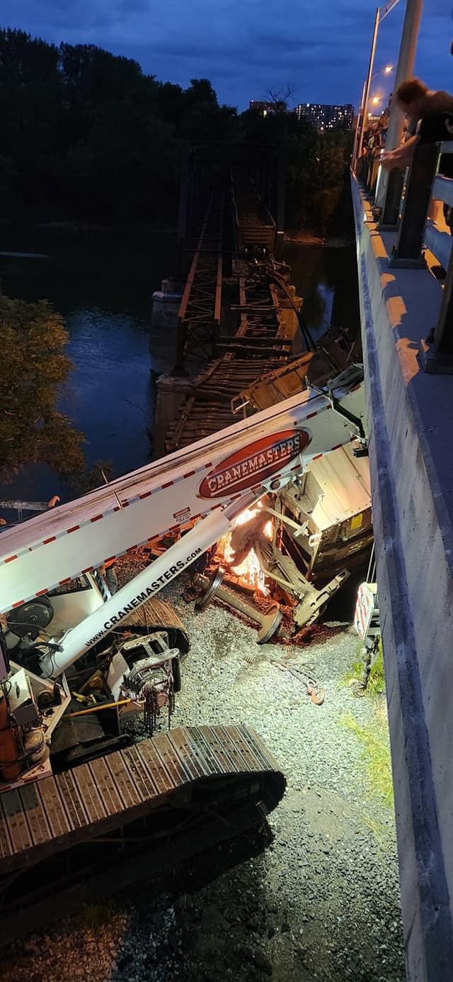
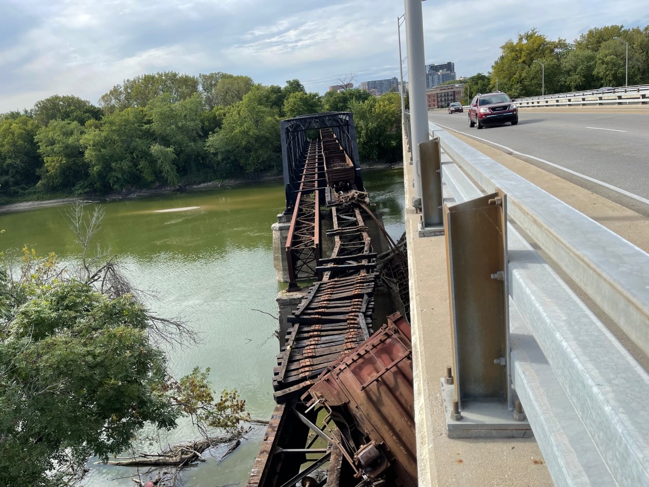
Jim Hobgood posted
Former Hwy/RR bridge across Tombigbee River between Pennington and Myrtlewood, Alabama, Labor Day 2020!

Rob Hinojosa commented on Jim's post
This was taken maybe 16 years ago I was part of the bridge gang that removed the road panels and guard railing converting this bridge to an open deck.

Billy Milstead | RuralSWAlabama.org via al.com
"It was one of two bridges in the world where cars and trains shared the same surface."
[The Cherry Street Bridge in Chicago used to share the same surface between cars and trains. But it is short and rather easy to see if it is occupied.]

Choctaw Chamber posted
Good morning folks! It's time for another #ThrowbackThurdsay brought to you by the Choctaw County Historical Museum! Pictured below is the world-famous "old" Naheola Bridge near Pennington. Built in 1934, it was once one of only two bridges in the world that accommodated both rail and automobile traffic on the same surface.
Did you ever travel across the Naheola Bridge? We'd love to hear your memories!
🔴For more information on other activities of the Choctaw County Historical Museum, "like" their Facebook page Choctaw County Historical Museum!🔴
(Photo provided by Mr. Tyler Reynolds)
Lee Herring shared
[There are lots of comments pointing out other bridges where rail and autos shared the same surface.]

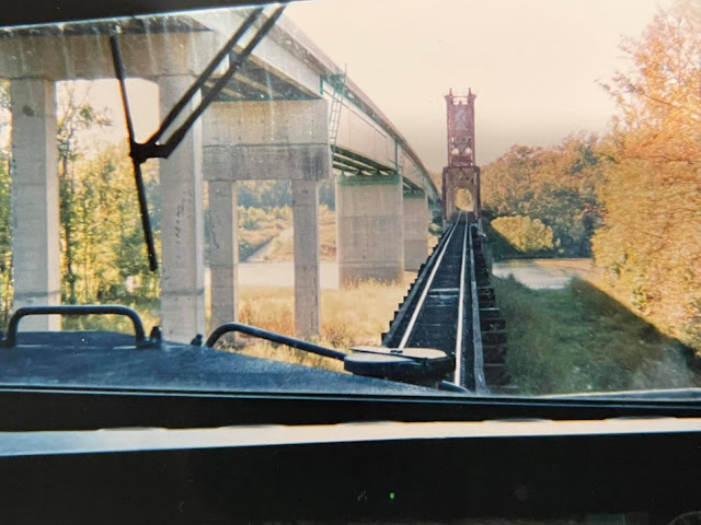
Daniel Kee posted
Myrtle Wood,Al 2005 Meridian BigBee Railroad
Jimmy Corder: Rode the railroad and highway bridge. BNSF has couple of tracks at the mill. [So does that mean BNSF runs trains to the mill using trackage rights?]
Don Trimble: Still have to hand crank the bridge? [I've never heard of a lift bridge being hand cranked.]


Sunday, August 30, 2020

BNSF/Santa Fe Causeway Bridges at Galveston, TX

(Bridge Hunter; Satellite)
Modern lift bridge with concrete arch approach spans over Galveston Bay on BNSF Railway (and former highway).
Built 1912, Original Bascule replaced in 1987; 1987 bascule span replaced in 2012 by a lift span.
[Bridge Hunter]

A combined railroad and vehicle causeway was built in 1893 using a swing span for the navigation channel and trusses for the other spans. But it got destroyed by a hurricane in 1900. The concrete arches we see today were built between 1909 and 1912 to withstand hurricanes. The arches survived a hurricane in 1915, but the earth filled sections leading to the bridge were washed away. When they were rebuilt, concrete was used instead of earth.

The lift span is significantly longer than the 1987 bascule span.

arema

safe_image for Rail bridge moved into place, Feb 14, 2020, James Nielson/Chronicle
Workers wait in the fog during as the new Galveston Causeway Railroad Bridge is brought in on Tuesday, Feb. 14, 2012, in Galveston. The 382-foot bridge will replace the old 125-foot span that connects Galveston to the mainland. Construction began on the $80 million project in June of 2010 and is expected to be completed by this coming June. BNSF Railway's Regional Director og Public Affairs Joseph Faust said: "It was a spectacular sight to see the structure appear in Galveston Bay” during the foggy morning float in of the bridge.

Tom Bell posted four photos with the comment: "Here are some shots for you all. firstly, replacement of the Galveston causeway bridge for UPRR/ASTF/SP/MP, now just BNSF and UPRR joint trackage."


The 1912 movable span was designed by Scherzer Rolling Lift Bridge Company.

Postcard via Bridge Hunter

The 1987 movable span was designed by the American Bridge Division of US Steel (Chicago Engineering Office). I-45 was replaced in 2003 and 2008 to widen the shipping canal and to provide 8 lanes of  traffic.
TexasFreeway

Patrick Feller Flickr, License: Creative Commons Attribution (CC BY)

New Galveston Causeway Railroad Lift Bridge 0219121402

This new lift bridge was very recently [2012] put into place to replace the bascule bridge. The existing channel was dangerously narrow and the Coast Guard had ordered it widened. The old causeway structure between the two towers will be removed.

 
Douglas Butler posted
From Flickr BNSF Railroad Lift Bridge in Galveston, TX.

Satellite
The 1987 span was moved to California to replace a swing bridge. According to the comments, it is the Haystack Rail Bridge that is being replaced. But it still (accessed 2020) has the swing bridge in the satellite image. Of course the satellite images have a delay. That span would have been an interesting load going through the Panama Canal.

The concrete arches were built between 1909 and 1912 to withstand hurricanes.
arema

arema

SMU Libraries Flickr via Bridge Hunter, 
Public Domain: Published Prior to 1923


arema

The concrete arches do appear to have passed the test of time.
Patrick Feller Flickr via Bridge Hunter, License: Creative Commons Attribution (CC BY)
BNSF Approaching Lift Bridge, Galveston Causeway

I wonder what those new I-45 causeways cost. It doesn't look very crowded. I assume the traffic level depends on tourist season and hurricane evacuations.
arema

I've remembered that concrete was a bleeding edge construction material at the beginning of the 20th Century. At four miles long, I wonder if this was the biggest project at the time in terms of the quantity of cement used. The arch strikes me as rather flat. I believe that would generate a lot of horizontal compressive force. That would have the advantages of pre-stressed concrete. Specifically, temporary tensile forces introduced in the structure by waves, etc. would not offset the internal compressive forces so that the concrete would remain in compression. That made me wonder if they could skip adding rebar. No rebar would explain why it has lasted so long even though it doesn't set very high above salt water. But these diagrams show that they did use rebar.

Via Bridge Hunter, Public Domain: Published Prior to 1923
[It looks like each span covered 78'. The 8' pier added to the 70' arch.]

Via Bridge Hunter, Public Domain: Published Prior to 1923
[This explains why there was originally three tracks, one was for interurban. The "County Section" was for road traffic.]


Saturday, August 29, 2020

Franklin Street, IL-40 and Cedar Street Bridges over Illinois River at Peoria, IL

1913-1993: Franklin: (Bridge Hunter)
1933+2010 Cedar: (Bridge Hunter, Historic BridgesJohn A. Weeks IIISatellite) Kudos to IDOT for rehabilitating a truss bridge in 2010
1993: IL-40: (John A. Weeks IIISatellite

Franklin Street Bridge


Given how tight two barges fit through this bridge, getting a standard tow of 3-barges wide through this thing must have been very exciting. Replacing this bridge with a high bridge that doesn't obstruct traffic was needed.
Peoria Public Library via Bridge Hunter

Matthew Bietz posted
Howard Keil shared
Good view of the damaged TPW swing bridge [one, two] in Peoria 1977 from the Julia Belle Swain riverboat headed south on the Illinois River.

Cedar Street Bridge


I never realized that Cedar Street was a cantilevered truss until I saw it in the background of the above photo.

I labeled these notes with "bridgeStrauss" even though Cedar Street is not the usual Strauss trunnion bascule design because he was the designer of this bridge. "It is interesting to observe the main span of this bridge. The way the cantilever arms meet in the middle [with a hinge], the way that the main span span has an arched shape, and the configuration of the truss as a Pratt all are similar to what you would find on a bascule bridge like the Jackson Boulevard Bridge. Perhaps we can see the influence of an engineer whose experience was with bascule bridges here in this fixed bridge?" The anchor arms use Warren, instead of Pratt, trusses. "In 1933, this bridge won the prestigious award of Most Beautiful Steel Bridge from the American Institute of Steel Construction."  [Historic Bridges]
Boston Public Library Flickr via Bridge Hunter, License: Creative Commons Attribution (CC BY)

Street View

Andy Moon, Jul 2016

Barriger

IL-40 Bob Michel Bridge


I'm reminded that Bridge Hunter doesn't document ugly-concrete-slab-on-girder bridges.
John A Weeks III

Cary Miller, Jun 2019, cropped


KB&S/(Big4+NKP(LE&W)) Bridge over the Wabash River at Lafayette, IN

(Bridge Hunter; no Historic Bridges; 3D Satellite)

I've seen this view a few times but ignored it because it is yet another truss bridge. But I've decided that about the third time is a charm.

HalstEd Pazdzior posted

"Through Truss 2 Track bridge(currently single track) once shared by the New York Central and Nickel Plate railroads. Reconfiguration of adjacent SR 26 and CSX and NS tracks forced realignment of East approach causing removal of 1 track." [BridgeHunter]
Indiana State Department of Natural Resource, Division of Historic Preservation and Archaeology via Bridge Hunter

Journal and Courier: February 12 1959 via Bridge Hunter


Ray Gray posted
The Big Four Railroad took a trainload of passengers to West Lafayette moments before the Main Street levee broke, sending the river slamming through the bottom lands and further endangering the city of West Lafayette. Loaded coal cars were pulled onto the bridge. The added weight kept it from being swept away. but it was knocked five inches out of line by floating buildings. History does not precisely define the "fluffy-ruffle brigade", but when the railroad bridge was the only connecting link between the two towns, ingenious Purdue students jumped from coal car coal car to get across the flooded river to visit their girlfriends in Lafayette. Before the river subsided, the on-rushing waters washed out foundations beneath the piers, leaving the bridge suspended, and it also had to replaced.
[Flood of 1913]

Dave Cobb shared

Lew Morris commented on Ray's post
From the Journal & Courier, 1913 https://www.jconline.com/.../february-1913.../79592740/ Note that the little ferry is powered by a paddle wheel. 15 more photos on the link.

Lew Morris commented on Ray's post
Ol' Wabash is looking more little O'Miss.

Sep 21, 2022 Derailment


C Kent McKenzie posted seven photos with the comment: "Derailment today (9/21/2022) with significant damage to this old bridge in Lafayette, IN. This is a spur that runs west from the NS mainline, just south of the Amtrak station, next to the South Street bridge. I've seen speculation in other groups that this won't be repaired, as there is an alternate rail route to the served industries. Photos by Clayton St Martin."
1

2

3

4

5

6

7

Brian Pruitt posted four photos with the comment: "Lafayette Indiana:  Kankakee, Beaverville and Southern Railroad. Tracks failed while pushing rail cars for storage. I formally nickelplate, conrail then NS rail bridge."
Eric DeHaan: How many cars got across before it fell in? Going to be interesting getting that fixed/who fixes it and get the cars back lol.
Brian Pruitt: Eric DeHaan I haven’t gone down there yet, but looks like three railroad cars that Norfolk Southern was going to store on kbs rail line for the Nucor steel plant in Crawfordsville.   Now it’s Norfolk Southern’s bridge and owns X amount of feet on the other side. It will be NS that will fix it.
Dan Kleinhenz: Looks like they were loaded with pig iron briquettes.
1

2

3

4

Brian Pruitt commented on his post
Where is his hard hat at?

WISH-TV posted six photos with the comment: "BREAKING: A train derailed Wednesday afternoon on a Wabash River bridge on the border of West Lafayette and Lafayette, the Lafayette Police Department says. What we know: https://bit.ly/3S1IQkz?utm_medium=social..."
(Provided Photos/Jeff Ooms)
Michael Perigo shared
1

2

3

4

5

6