Wednesday, December 31, 2014

Western Kentucky Railroads: PAL, FVRR and WTNN and KWT

Puducah and Louisville Railway (PAL)


Photo by Douglas Weitzman
4/2/16. Paducah & Louisville 1998 at Louisville, Ky..
The Paducah and Louisville Railway (reporting mark PAL) is another Illinois Central remnant. It began operations in 1986 as a 223-mile Class II regional (AmericanRails). According to my 1928 Railroad Atlas, the IC had a line that went generally south of Louisville through West Point to Cecilia. Then it headed generally west along US-62 to Paducah. According to the PAL system map further below, they also have the former IC trackage from Paducah to Kevil and another route through Mayfield to Clayburn and the IC branch from Ceclia to Elizabethtown.

PAL has significantly grown the number of customers served by the railroad since it purchased the track from ICG. I was looking at the type of products handled in their list of customers and noticed "Locomotives" for Progress Rail Services in Mayfield and VMV Paduchbilt in Paducah. That gives me a couple of more industries to research.

Photo by Douglas Weitzman
4/2/16. Dawn. P&I 1803, original colors but very dirty, on a ballast train
 in Jeffersonville, In..
I was also surprised by how many locomotives are on the roster. The roster looks more like a railroad museum than an active railroad. The oldest locomotive I spotted was 1302 (SW13) built in 1940. There were several SDMAC70s built in 1997, which are their newest locomotives. A lot of their locomotives are from the 50s and 60s.

Since 2006, the P&L also operates the Appalachian & Ohio Railroad in West Virginia on former Baltimore & Ohio trackage. But this is not the reason the P&L roster is so big. The West Virginia operation has retained the A&O name and it has its own roster. But they use CSXT power to move the coal trains, which is the bulk of their traffic (Wikipedia).

Please access Cliff's posting. In addition to a picture of the first IC train across the Barkley Dam, he provides some history of the IC over both dams.

Below is the system map with the "rail connections" layer activated.  Later I describe the FVRR and WTNN. I could not find Clayburn on the Google Map or my 2014 Rand McNally Road Atlas.

P&L

MMI
The P&L is doing some serious infrastructure improvements. MMI did not indicate where this steel trestle was being replaced. But IMI indicated it was one of a couple of 100 year old trestles near West Point, KY.
IMI
The US Government would have paid for the new bridge just downstream of the Kentucky Dam as part of a relocation for the construction of a 110x1200-foot lock to remove the delays caused by the current 110x600-foot lock.

Fredonia Valley Railroad (FVRR)


The IC had almost as strong a presence in western Kentucky as did the Louisville & Nashville. In addition to the east/west route that became the PAL, it had a north/south route that ran through Henderson-Blackford-Princeton-Hopkinsville. I still need to research if the IC had a bridge over the Ohio River to connect Henderson with Evansville and its PD&E route.  The FVRR is a 7-mile remnant of this route that runs north of Princeton. It was reactivated in 1998 to connect a quarry to the PAL in Princeton (kyrailbeds).

Satellite
The Google Road map shows only about half this distance. But following the track on the satellite image, it is intact to an aggregate quarry. There were 24 cars being loaded and an engine was parked on a siding at the entrance on the southeast side of the quarry. I wonder if this quarry helped supply the fill for the Kentucky Dam.


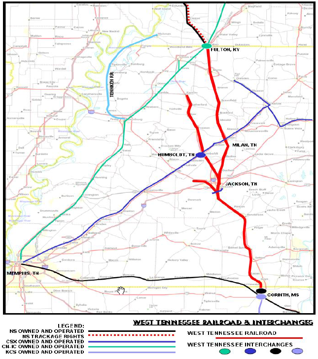
West Tennessee Railroad (WTNN)


The WTNN was formed from remnants of the Mobile & Ohio and the Illinois Central. The reason for researching this railroad is that the above P&L System Map showed an interconnection with it south of Mayfield for traffic going to Cornith, MS. Note from the following system map that the northernmost town connected to the TWNN is Fulton, KY. The Paducah-Mayfield branch of the P&L is a remnant of an IC route that went from Paducah to Memphis through Mayfield and Fulton. But a study of the Google maps indicates the P&L stops a couple miles south of Mayfield in some industrial buildings. So I don't know how the interconnection is done given the "hole" in the former IC trackage between Mayfield and Fulton. And TWNN does not claim that they connect with the P&L.

TWNN Brochure


The roster for the TWNN also has the feeling of a museum. Of note is four ALCO RSD12s built in 1956. There is a nice collection of engine photos on RailPictures. 1853 is one of the RSD12s.


Update: Kentucky West Tennessee (KWT)


Genesee & Wyoming
KWT operations include the remnant of a Nashville, Chattanooga, and St. Louis (NC&StL) branch between a couple miles north of Murray, KY to a former-NC&StL mainline that runs past Bruceton, TN that is now part of CSXCapacity: 263k in Kentucky; 286k elsewhere

Genesee & Wyoming

Murray has developed an industrial park on the north side of their town where some of the industries such as Pella and Vanderbilt Chemical Corporation take advantage of rail service from KWT. Unlike Class I railroads, shortlines encourage industries along their route to use rail service.

Thursday, December 25, 2014

IHB Calumet City (State Line) Yard and CSXT/BOCT/B&O Mainline

(Satellite)

I'm used to towers in the Chicagoland area having more than one name, but that is unusual for yards. However, I have come across three yards that some sources call "State Line:"
Because it is ambiguous, I avoid using the name "State Line Yard" in my notes. Although I've noticed that it is important to qualify "Burnham Yard" with the owner of the yard: IHB vs. CSS.

B&OCT Map, 134th is 136th in Indiana

Ben Elliot posted the comment:
Would anyone know about operations at the IHB Calumet City aka State Line Yard. What I am wondering specifically is what is the general function of the yard, e.g. Local Customers, etc.
Also, would traffic be delivered there directly or would it have been fed from Blue Island, or elsewhere for that matter.
Ean Kahn-Treras Are you referring to N. State Line Yard just north of State Line Crossing, or the small yard west of Homan Ave crossing on the border of Hammond and Burnham?
Bob Lalich Ben Elliot - if you are referring to the IHB yard between Hohman Ave and Calumet Park, I believe NS delivers interchange there. I'm not sure if there are any carload shippers still in the immediate area. The IHB yard north of the South Shore along the state line is called Burnham Yard.
[Additional comments established that Calumet City WAS an interchange yard with NS.]
Mike Breski Most of the cars for Calumet City industries came from Blue Island. Cars set out for interchange would go to Blue Island for classification. Ii's been a while since i worked for IHB memory a little foggy as far as what roads set out there. Yard is on Calumet City Burnham border under Burnham ave bridge about a mile south of CSSSB between Hohman and Calumet Park as Bob Lalich stated. When i worked at the Gibson West End before it became auto rack land one month NS would deliver next month we would pick up from Osborne [Yard].

The yard does still exist, and it doesn't look like it is just used for storage. So today's usage is still a mystery.
Satellite

Flickr from John W. Barriger III IHB Album
Bob Lalich identified the building in the distance is Calumet Park Tower.

We obviously are looking under the Burnham Avenue overpass. But are we looking East or West. And why are there tracks on both sides of the mainline? That is not true in today's satellite image. So I fired up the time machine of 1939 aerials. As expected, there were a lot more tracks in this area back then. So many, that I included two excerpts: west and east of the overpass. The above view is looking westish. I put a red rectangle around the water tower and a blue rectangle around the junction tower.

1939 Aerial Photo from ILHAP, west of Burnham
The east/west tracks in the middle right above the water tower is B&OCT that B&O uses for entrance into the Chicago area.

What industry has that narrow building along the south side of the yard? Are they separate small buildings or skylights on a really long, skinny building? According to a comment by Bob Lalich on the following Flickr photo, they are stockyards. And that facility south of the IHB tracks and west of Burnham Ave. was the IHB Calumet Park Yard.

Flickr from John W. Barriger III IHB Album

Carl Venzke posted
Calumet City, Illinois. Part of the Calumet Park stockyards, run by the Indiana Harbor Belt railroad as a stock watering, feeding, and resting point. The law required that stock be watered, fed, and rested every thirty-six hours of a journey. Jack Delano photo, January 1943.
Bob Chaparro: Carl - Your caption is misleading. The 28-hours law had been in effect since at least 1906 and probably earlier. The 36 hour limit required a waiver. While livestock had been shipped by rail for decades, losses were significant. Shippers, railroads and government were looking for ways to reduce losses and claims. The 28hr law required livestock to be unloaded, fed, watered and rested for a minimum of 5 hrs every 28 hrs. The confined time could be extended to 36hrs via a waver signed by the shipper/owner of the livestock. If confined for 36 hrs, the required feed rest period was extended to 8 hrs. Exceptions were hogs could be fed and watered in the car. And sheep could remained confined until daylight, as sheep apparently will not move easily in the dark. This law eliminated any attempts to feed and water livestock while confined in moving cars. Stock car designs before 1906 often included water troughs and feed boxes.
Carl Venzke: Bob Chaparro Thanks Bob, I just repeated the caption that came with the photo. I suspect that during the war there were a lot of waivers signed.
[There are more comments about the 28-hour rule and about the dual-level ramp for smaller livestock.]
 
Mike Breski posted
NEW YORK CENTRAL CALUMET PARK STOCKYARDS OPERATED BY THE INDIANA HARBOR BELT IHB
Calumet City, Illinois. Unloading horses at the Calumet Park stockyards
Photographer
Jack Delano
Created
January 1943
Location
Calumet City, Cook, Illinois
Lot Number (Shooting Assignment)
222
Call Number (Library of Congress)
LC-USW3-015504


Most of the yard tracks west of Burnham are now gone. But some of the tracks on the east side still exist. Most of the industry on the east side has not been replaced by new industries.

1939 Aerial Photo from ILHAP, east of Burnham

Bill Rogerson posted
Hammond, Indiana. Indiana Harbor Belt Railroad train on the Michigan Central Railroad tracks. Both the Indiana Harbor Belt Railroad and the Michigan Central Railroad are subsidiaries of the New York Central Railroad. January 1943
Jack Delano Photo
Hohman interlocking. This train is pulling onto what is called today the Calumet City Lead, heading for Calumet City Yard.

Dennis DeBruler commented on Bill's post
Another view of the bridge:


20140921 0107
Since the grade separation work for S. Torrence Ave. with NS/NKP and South Shore Freight does not allow one to go south on Torrence, I took the detour down S. Brainard Ave. to Burnham Ave. I turned east on Sibley Blvd and parked at the east end of Harding Ave. From there it was a short walk to the pedestrian walk of the overpass of the IHB and BOCT tracks. I took all of my pictures from over the IHB tracks. The first picture I took was of a Pillsbury covered hopper. From a Facebook comment I received from William Brown concerning the following posting of the tops of genset engines I learned that Pillsbury discontinued their Grain Group in 1988.

1980 photo by Eric Gagnon, used with permission
(Update: Eric Gagnon explains the history of the Pillsbury car and why there are three rust spots on each side of the "u".)


I had already caught IHB 2161 near the north end of IHB's trackage. In that posting I describe gensets. Note in this picture that all three gensets are active in each of the units.


But the picture of the other side of the Pillsbury car gets me ahead of the story. The first yard photo I I took was from the northeast side of the overpass looking east. All of the cars that you see were stationary; that is, they were parked. The empty track, tank cars, and vehicle cars are on the IHB mainline. The tracks to the left of the three mainline tracks are the IHB Calumet City Yard.


There is at least one engine on the far end of the vehicle cars, so this train is eastbound and is probably waiting for clearance to enter the IHB Gibson Yard. I read in a Trains Magazine article that Gibson is now the clearing (switching) yard for all vehicle trains in the Chicago-land area. The direction of the vehicle train is confirmed by a picture from the west side of the overpass facing west.


You can see the end of the vehicle train and that there is no engine on the west end. Because of the gondola cars we see above, and the lumber car and four box cars we see in the close up to the left, the "tank car" train is really a mixed freight. Because the train goes around a curve, I can't confirm that it is a westbound train, but I assume there are engines attached and these cars are not in storage. The only "fallen flag" I spotted is a Southern Pacific vehicle car.


13:06:04
And then I heard some diesels. When I looked east, I saw headlights in the distance.
When I zoomed in to the camera's resolution, I determined there are two engines pulling the vehicle train. As every IHB train that I have seen, this train was moving slowly. Because of the slow speeds of the trains in this area, I'm including the timestamps as captions. I then determined that I was probably hearing the diesels on this intermodal train to the northeast.

13:06:54

13:07:04
This was also a slow moving freight. It took about 4 seconds to travel the length of a car. This gave me time to find the engines in a northwesterly view. I took several pictures so that the numbers should be visible in at least some of them. This is just one of the engine shots. They were BNSF 7132 (ES44C4) and 5528 (C44-9W, built in Aug. 2004). Note that these BNSF engines are pulling a CSXT train. I know that the former Baltimore & Ohio tracks go through Garret, IN, so I traced the tracks to Chicago to verify that these tracks are part of that route. A map (select Chicago Terminal Area with Vicinity Railroads and Industries) marks the track as BOCT east of N. Hammond and as CSXT east of N. Hammond. (BTW, this is the best map I have found so far of the Chicago area. One reason is that it names the small yards as well as the major yards. This map is how I found the Calumet City Yard name. Another reason is that it includes major highways so that it is easier to correlate this map with regular road maps. And it explicitly shows grade separations.)
13:07:24
I spent the next several minutes catching the painfully slow progress of these two trains.
13:07:38
I thought the reason cars took a long time to get across Chicago is because they set in yards. I'm learning it takes a long time because they go sloooow. To the right, the BNSF engines are just beyond the two blue stacks on the other side of the orange stacks as shown in the following closeup.


The above "gensets plus Pillsbury shot" was at 13:07:54. In the following three pictures, we can see the progress of the engines of both the IHB and BOCT/CSX/B&O trains.
13:08:08
13:08:10
13:08:16
Then I focused on getting pictures to determine the car types for the IHB train.

13:08:44

The above view also provides a closeup of the track layout. It appears the Google road map is not correct. But studying the satallite map explains why the westbound mixed-freight next to the eastbound vehicle train is parked. It is yielding to the active mixed freight because the tracks soon merge.  This train not only had the normal coil cars -- gondolas with curved covers -- but some flats with covers I have never seen before. I counted these as coil cars since they probably have something to do with the steel industry in southern Chicago and northwestern Indiana and because they were blocked with the regular coil cars.


I took another picture to timestamp the end of the train. Note that it has just a red flag added to mark the end of the train.

13:09:16

And another timestamp of the progress of the trains.

13:09:46
The CSXT train has an End-of-Train Device that measures and reports information such as the air-line pressure. (Trains)

13:10:22

This summary of the mixed freights does not include all of the parked train since it went around the curve on the west end and there were some cars under the bridge that were not in the photos.


parked moving
3-bay 1
4-bay
2
white tank 17 12
black tank 45 22
railbox 5
gondola 4 1
coil
6
lumber 1 2

72 46
So it took the 48-unit IHB train about 2 minutes and 20 seconds to pass.

Update: Randy Olson posted three pictures of two trains at the east end of the yard.

Bob Lalich Flickr Photo at photo resolution


Monday, December 22, 2014

BNSF/SantaFe GM Yard

(Satellite)

These notes are about the yard.

It is called the GM Yard because the UPS land on the other side of I-294 used to be a GM stamping plant. On one of my trips northbound on I-294 they were doing construction and the shoulder was one of the legal lanes so I was able to get some views over the bridge's side barrier that are normally not legal.

20140921 0172c
On the right side is a stock pile of "snap track." I assume this is used for emergency repairs of track torn up by a derailment.

The bridge in the above view is US-12 and according to the map the yard extends about the same distance beyond the bridge.


The engines that were shoving a string of cars back and forth were probably switching this yard.

I think the engine on the left side of the above picture, which is at camera resolution to the left, is BNSF 2593. The picture on the right is a screen snapshot after zooming in further with Windows Photo Viewer. The reason for my hesitation is that the resolution is bad and that Diesel Shop does not have this number. The three engines listed in the 25xx series were built in the middle 1960s.

The three locomotives on the right are BNSF 527 and 547, both of which are B40-8W built in Oct. and Nov. of 1990, and 2016 is a GP38-2 that NRE rebuilt from GP40 ( Ex-GTI GP40 1385, exx-NS 1385, nee N&W 138).


What initially caught my eye is how much the orange color for 527 has faded. At first I thought it was a warbonet where the red had faded to pink. Both of these pictures are at the camera's resolution.


Looking at satellite views, engines are regularly parked here. And since they are assigned to yard work, they are probably old engines. But there doesn't appear to be any public roads that allow you to get better pictures of the engines. I'll have to try to do another trip with the minivan and use a longer lens and aim for the engines from I-294 while someone else drives. Note that the older Bing shot has a "warbonnet" paint scheme.

Google
Bing
Jerry Jackson posted the following two pictures with the comment:
Pulling out of the old GM yard in Willow Springs. This afternoon's local has two GP30u's, one GP39-2 and three GP35u's, not necessarily in that order, heading to Joliet. It's funny looking back as you could also see these units on any high priority train too. 1989.
Used with permission. Note that was a local serving industries just to Joliet. And 1989 is a couple of decades after the interstates were built. I wonder how small the local is now.

1

2
Update:
A view from an MWRD tour bus. Note the green locomotive and the yellow Herzog MPM behind it.
20170806 1553
Alex Ertmann posted
Various power in GM Yard in Hodgkins, IL on 1/23/2018.
Ryan Drake commented on Alex's posting
I see GP50 3121 in the left. That unit worked in Nebraska for a few years.