Thursday, December 31, 2020

Green Steel: DRI, HBI and Finex

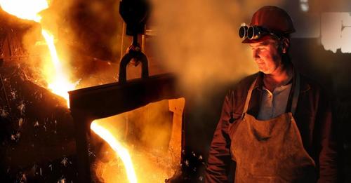
I had assumed that the CO2 emissions for making steel with blast furnaces was because of the burning of the coke to provide the needed high temperatures to melt the rocks (iron ore and limestone). And the making of the coke itself also produces a lot of emissions. But I've learned that another source of CO2 in the blast furnace is the reduction of the iron ore. "Reduction" means ripping the oxygen atoms out of the iron ore to leave pure iron. The reduction is done by the carbon atoms in the coke combining with the oxygen atoms in the iron ore to create CO2 and CO. If you grab the oxygen atoms with hydrogen instead of carbon, you create H2O instead of CO2. Of course, H2O is simply water vapor, which is not a greenhouse gas. Powering a blast furnace with hydrogen instead of coke is called direct reduced iron (DRI). An intermediate step towards green steel is using natural gas instead of coke. Since natural gas is mostly methane, CH4, this reduces two of the iron's oxygen atoms with hydrogen instead of carbon. So the CO2 emissions are a third of that emitted when using coke.

This Mitsubishi article below indicates that the cost of hydrogen needs to be an order of magnitude (a factor of 10) cheaper than it is now to be competitive with using coke as the reduction agent. But they expect society will be beefing up the world's hydrogen infrastructure and that those cost reductions will be realized.

safe_image for Mitsubishi Heavy to build biggest zero-carbon steel plant [paycount]
Mitsubishi Heavy Industries will build the new hydrogen steel pilot plant at a complex of Austrian steelmaker Voestalpine.   © Reuters
"Iron ore reduction accounts for much of the CO2 emissions in steelmaking. Japanese steelmakers including Nippon Steel are developing hydrogen-consuming reduction processes based on the conventional blast furnace design. Mitsubishi Heavy's plant adopts a process called direct reduced iron, or DRI. New blast furnaces require trillions of yen (1 trillion yen equals $9.6 billion) in investment. Although DRI equipment produces less steel, the investment is estimated at less than half of blast furnaces. For DRI to attain the same level of cost-competitiveness as blast furnaces, low-cost hydrogen will be key. Market costs for hydrogen now stand at around 100 yen per normal cu. meter, estimates the Ministry of Economy, Trade and Industry. The government aims to get the hydrogen costs down to 30 yen per normal cu. meter by 2030, mainly via mass production. But for DRI to be feasible in the steel industry, 'the level needs to go below 10 yen,' said an executive at a large steelmaker....Mitsubishi Heavy will capture the steel industry's demand for hydrogen to offset the softer growth prospects for thermal power plant equipment."
Jim Hewett Jr.: Interesting. That mill is no stranger to new technology. VoestAlpine is used to being a pioneer in the steel industry. That is where the very first B.O.F. was developed.
Richard Allison: The whole idea is to inject coke oven gas and hydrogen into tuyeres of blast furnaces to reduce CO2 by 50% by 2030. Blast furnaces will still use a little bit of coke and blast furnaces will never be zero percent carbon so HBI and DRI will be using green hydrogen, not gray hydrogen to be produced and melted down in EAFs and replacing blast furnaces. Blast furnaces will start closing down soon but ones still operating by 2030 will have to have 30% cut in CO2 and all of them by 2050. Some steel companies are accelerating this plan to happen sooner. That is one reason AM sold the US operations. This is a win for steel companies because they will be supplying steel to build hydrogen infrastructure and make steel with much fewer steelworkers.

safe_image for video
[At 2:40 it indicates that the process generates carbon monoxide and hydrogen instead of CO2. Both of those gases are combustible. Although the burning of the CO will create CO2.]

safe_image for This Steel Giant Is Winning With a New Brand of Environmentally Friendly Steel
["Econiq" steel. Is it an EAF and carbon credits that make it a game changer? I was expecting the use of hydrogen instead of coal. Actually, in the article they say "To be fair, this isn't a game changer for Nucor per se." The significance of Econiq is that auto manufactures are accepting it for their use. EAFs have had trouble competing with blast furnaces to make steel that is good enough to be stamped into autos because they can't get rid of some of the impurities in the scrap steel.]

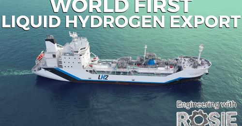
safe_image for World's Dirtiest Clean Energy Project (and Why I'm a Fan) video
Green Steel is steel that is made in an EAF that is powered by an electric generating plant that uses hydrogen as the fuel. Natural gas emits carbon. Car manufacturers that are "woke" to the green economy will require green certificates that any steel they buy will be green steel.
Green steel is what is going to put integrated steel plants out of business by 2050 or before. That is 28 years from now and many steel companies, especially in Europe are going to have green steel in the next few years. Green Steel is going to cost jobs at the blast furnaces, BOFs, coke plants and sinter plants which will be several thousand in the US alone.
Climate change is real because the Earth is not static and has always run in cycles like the sun that has 11 year cycles. As far as I know, man has not been able to change weather let alone climate. My feeling is that it is easier and cheaper to adapt to changes on the Earth. Ruining country's economies and the middle class that makes the US a great country is not rational and about as irrational as using hydrogen which does not emit carbon (which is not a problem) but takes lots of carbon to produce and distribute.
Check out this video that tells the story better than what I can convey.
John Groves
Here is another new Green Steel technology claiming it will be commercial by 2025.....
Startup promises green steel by 2025 as decarbonisation race heats up
[She is a fan because she think the project will prove that transporting hydrogen as a liquid will fail and that will save investing $300 billion in a hydrogen solution that won't work. (Rosie also has a link to a carbon capture video.) Richard evidently thinks it would be cheaper to build a dyke and locks along our coastline than switch steel to green technologies. I think he is wrong that hydrogen would be used to make electricity to run EAFs. If you have hydrogen, blast furnaces can be run cleanly.]

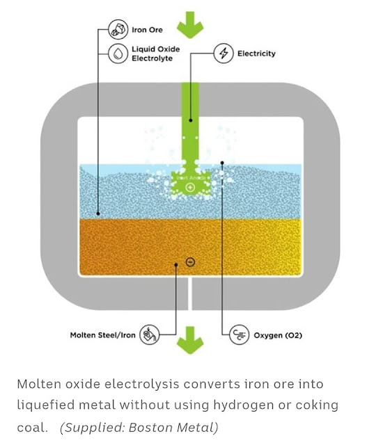
John Groves posted
STARTUP PROMISES GREEN STEEL BY 2025
Basically, Boston Metal plans to run electricity through the iron ore. This is how aluminum is smelted. To make aluminum for planes in WWII is why the TVA built the 1943 Appalachia and 1945 Fontana Dams in the wilderness. of the Appalachia Mountains. If this works, this would be a lot better than the current plan of making hydrogen with electrolysis.


Friday, December 4, 2020

1965 Sanford Dam on the Canadian River

(Satellite)

While looking for a railroad bridge on a satellite map, I noticed a big, long lake. Whenever I see a long lake, I check to see if one of the ends is a straight line. Sure enough, Lake Meredith is straight on the east end. Zooming in, I noticed that the spillway structure was rather unique. So I decided to research this dam.

US Bureau of Reclamation
"The Sanford Dam is a zoned earthfill structure with a crest width of 40 feet, a crest length of 6,380 feet, and a structural height of 228 feet. The spillway has an ungated morning-glory entrance structure, a 22-foot-diameter concrete conduit, and a chute and stilling basin. The reservoir formed by Sanford Dam, named Lake Meredith, has a surface area of 30,466 acres at maximum water surface and a total capacity of 1,407,572 acre-feet."
[Actually, that maximum is the "controlled storage capacity" when the water level is at the spillway crest. It can hold an additional 1,206,643 acre-feet to control extreme floods.  [33:34]]

I'm learning that water supply is an important function for dams in Texas. The Denison Dam is contracted to supply 125,000 acre-feet to local communities. And this dam is owned by a water authority.

The outlet pipe is a normal design. It is interesting to note that no water is flowing out of it. That is because the building at the base is a pump house that sends water south to the communities that are helping to pay for the dam.
Satellite

And the 22' diameter morning-glory emergency spillway with chute and stilling basing is not too surprising. Although, in practice, I don't see morning-glory spillways too often.
Satellite

But what was surprising is the spillway that goes around the regular emergency spillway. I'm going to call it the trench spillway. Obviously, it can pass water long before the water reaches the flood pool at the morning-glory spillway elevation.
Satellite

Before discussing the trench spillway, let me note that the morning-glory spillway has three "prongs." How do they help the flow? By adding some air to the water flowing through the 22' concrete conduit?
Street View

Back to the trench spillway. A key is that the watershed of this dam is the desert in New Mexico. In fact, the panhandle of Texas is also desert like. There is less than 20" of rainfall in a good year. [1:30] That means it very seldom rains, but when it does rain, it pours and much of the water ends up in the rivers because desert soil does not absorb water very well. I had already noticed that the Canadian River has carved a well defined valley when I studied the BNSF/SantaFe Viaduct. To verify the bursty nature of the river, I verified that the first road downstream of the dam is normally a long bridge over dirt.
Street View

Some lake levels of interest: [WaterDataForTexas-water via twdb, volume and area via twdb-survey via twdb] 
LevelElevationDepthDistance from TopAcre-FeetAcres
Top3,0111980
Design3,004.919262,614,215N/A
Flood2,965152461,407,57230,466
Conservation2936.5123.574.5817,97016,411
Dead28503716138,4142,723

To summarize:
FinalReport, p70

The flood level is the crest of the spillway. I think the dead zone level is the height of the outlet pipe. Below, this level, the pumps would be sucking air. There was a drought during 2012 and 2013 when the pumps were dry. The water authority did buy water rights and drill a bunch of water wells in 2001. Even if the pumps are not dry, they blend in well water to reduce the salt level. [crmwa-facts] During the first 40 years, the dam provided over 3 million acre-feet of water. [33:50] But water has still been removed from the Ogallala aquifer. It recharges at a rate of only a quarter-inch/year, and it takes thousands of years for today's rain to get to the Ogallala. [crmwa-overview] Before the dam was built, about 400,000 acre-feet of rain water was lost down the river every year. [4:14]

The record high of 101.85' was set in April 1973, and the record low of 26.14' was set on Aug 7, 2013. [crmwa-overview] So neither spillway has been tested, but the pumps have gone dry.

The boundaries of the Lake Meredith National Recreation Area should at least surround the flood level of the lake. How much of the design level of the lake is protected from development, I don't know.
USGS

crmwa-overview

The fact that a 228' tall dam has no hydroelectric plant is another indication that the normal flow in this river is negligible. Even though it does not have a hydroelectric plant, it does have a conservation pool elevation of 2,936.5 (74.5' below the top). I believe that is the bottom of the trench spillway. So normally, a hydroelectric dam can pass water through its turbines when the level of the reservoir is above the conservation level. But in this case, the dam can pass water downstream when the level of the reservoir is above the conservation level. In fact, it is obligated to. Agreements between New Mexico, Texas, Oklahoma and the Federal governments control how much water can be retained for conservation before water has to be released to the next government entity. But the 1950 agreement below specifies 500,000 acre-feet instead of 817,970, so I'm still a little confused.
WaterDataForTexas

The correct term for the "trench spillway" is the Flood Control Outlet Works. [9:18]

The narration says each of the three concrete conduits are 15.5' in diameter. But they look rectangular to me.
Screenshot

Downstream of the control gates, the conduits are described as horseshoe shaped with a height of 17' and a width of 17'. Recall that the emergency spillway on the left in this image is fed by a 22' diameter conduit. I was not able to find any cubic-feet/sec figures for the outlet pipe nor these spillways.
Screenshot

As we have seen with the BNSF/SantaFe Bridge and the road bridge above, the Canadian River flows through in a natural valley. I presume the flow rate of the three conduit structures is easily handled by that valley. The additional flow rate added by the emergency spillway would be a tradeoff between causing flood damage downstream and risking water flowing over the crest of the dam. The spillway level for the Denison dam was designed for a 500-year flood. Unfortunately, it has already seen five "500-year" floods since it was built in 1944. In contrast, Oklahoma has never received a drop of water from this river because the water level has yet to reach the conservation level. In fact, looking at the above graph, it would not have received any water since 1988 if the dam had been built to the 500,000 acre-feet specification.

I included the towns of Sanford and Fritch so that you can get a sense of scale as to how small the reservoir was during the drought.
Global Earth, Dec 2013

Texas has Global Earth images for every December since 1984. That is the first time I have seen so many images for the 21st Century. Until the turn of the Millennium, the reach of the lake stayed close to the green line with a tree. And then it began to shrink.
Global Earth, Dec 1984

This survey is up to just the conservation level. The Texas Water Development Board is concerned only about the water that they can keep.
FinalReport, p74

FinalReport, p75

Thursday, December 3, 2020

CSX/L&N Gum Lick or West Fork Pond River Trestle

(Bridge Hunter; Satellite)

This is interesting how such a little creek created such a sharp valley.

Jim Pearson Photography posted
CSX Q028-10 Atlanta, GA - Chicago, IL
CSXT 5412 leads hot intermodal north Q028-10 across the Gum Lick Trestle between Kelly and Crofton, Kentucky as the last rays of the fall sunset rakes through the valley on the Henderson Subdivision on November 10th, 2020.
Tech Info: DJI Mavic Mini Drone, JPG, 4.5mm (24mm equivalent lens) f/2.8, 1/400, ISO 100.

Jim's "Gum Lick" name comes from the fact that the valley is named Gumlick Hollow.

USGS Map, search for Crofton, KY and then follow the railroad south

Jim Pearson Photography posted
Southbound Intermodal at Gum Lick Trestle
CSX Q029 heads south, across Gum Lick, the highest trestle on the Henderson Subdivision, in the frigid cold, on February 19th, 2021 as the morning light rakes across the landscape sending shadows across the forest floor.
The "Gum Lick" name comes from the fact that the valley here is named Gum Lick Hollow and it sits between Crofton and Kelly Kentucky where it crosses over the West Fork of Pond River.
It's located between J. Knight road crossing and the Cavanaugh Lane overpass.
Tech Info: DJI Mavic Air 2 Drone, RAW, 4.5mm (24mm equivalent lens) f/2.8, 1/1000, ISO 100.

Jim Pearson Photography posted
CSX hot intermodal rolls south across Gum Lick Trestle
This picture really shows the difference a day or so can make! Two days before there was about 4-6 inches of snow at this location and the temperature was 17 degrees and on this day if was 65 degrees!!! Makes for very different photos, but both situations make for great photo possibilities!
Here we have hot intermodal CSX Q029-23 with CSXT 928 leading on February 23rd, 2021 as it makes its way across the Gum Lick Trestle between Crofton and Kelly, Kentucky on the Henderson Subdivision on a beautiful winter (kinda) day.
Tech Info: DJI Mavic Air 2 Drone, RAW, 4.5mm (24mm equivalent lens) f/2.8, 1/800, ISO 100.

Jim Pearson Photography posted
CSX S988 heads south over Gum Lick Trestle, just north of Kelly, Kentucky with two new Brightline Green and Pink commuter train sets, with UP 5970 leading, as they head for Florida, on the Henderson Subdivision on July 16th, 2022.
The “Gum Lick” name comes from the fact that the valley here is named Gum Lick Hollow and it sits between Crofton and Kelly Kentucky where it crosses over the West Fork of Pond River, and it is the highest trestle on the CSX Henderson Subdivision.
These train sets were built by Siemens in Sacramento, California and are destined for service along Brightline’s routes in Florida.
According to Wikipedia: Brightline is a privately run intercity rail route between Miami and West Palm Beach, Florida that runs on track owned by Florida East Coast Railway. An extension from West Palm Beach to Orlando International Airport is expected to open in 2023.
Brightline is the only privately owned and operated intercity passenger railroad in the United States. Its development started in March 2012 as All Aboard Florida by Florida East Coast Industries; a Florida real estate developer owned by Fortress Investment Group. Construction began in November 2014 and the route opened in January 2018.
Tech Info: DJI Mavic Air 2S Drone, RAW, 22mm, f/2.8, 1/1250, ISO 120.
Jim Pearson Photography: https://fineartamerica.com/.../csx-s988-heads-south-over...

Jim Pearson Photography posted
Well, today I caught my first one of the new CSX Heritage series locomotives, the Seaboard System unit, as it made its way across the Gum Lick Trestle, between Kelly and Crofton, Kentucky. It was leading CSX I026 northbound on the Henderson Subdivision on July 4th, 2023. I like how CSX is painting these units showing the new transitioning into the old.
According to Wikipedia: The Seaboard System Railroad, Inc. (reporting mark SBD) was a US Class I railroad that operated from 1982 to 1986.
Since the late 1960s, Seaboard Coast Line Industries had operated the Seaboard Coast Line and its sister railroads—notably the Louisville & Nashville and Clinchfield—as the "Family Lines System". In 1980, SCLI merged with the Chessie System to create the holding company CSX Corporation; two years later, CSX merged the Family Lines railroads to create the Seaboard System Railroad.
In 1986, Seaboard renamed itself CSX Transportation, which absorbed the Chessie System's two major railroads the following year.
Tech Info: DJI Mavic 3 Classic Drone, RAW, 24mm, f/2.8, 1/2500, ISO 150.
https://fineartamerica.com/featured/csx-heritage-series-locomotive-seaboard-system-1982-at-gum-lick-trestle-jim-pearson.html


Wednesday, December 2, 2020

1941 Pensacola Dam and the Grand Lake O' the Cherokees on Neosho (Grand) River

(Bridge Hunger; Satellite and Satellite)
Main Spillway: (Satellite)
East Spillway: (Satellite)

Massman Construction Co. posted two photos with the comment:
The Pensacola Dam impounds the Grand River to form Grand Lake o’ the Cherokees, providing hydroelectric power, flood control, and recreational benefits to the state of Oklahoma. We served as the contractor for the main superstructures, including the powerhouse and dam.
The project illustrates the powerful role infrastructure investment can play in times of economic distress – we employed approx. 3,000 workers at the height of the Great Depression.
A record setting structure, it is the longest multiple-arch dam in the United States and the second longest in the world and included a continuous 510,000 CY concrete placement that lasted 20 months. Our contract required the largest construction surety bond ever written up to that time.

1

2

405magazine, photo and article by M.J. Alexander
"The 51 arch barrels section traverses the Grand River for 4,284 feet; the length of the dam plus the spillways total 6,565 feet." It was built between 1938-1941, and it was the longest multiple-arch dam in the world. It is now 20' shorter than Canada's Daniel-Johnson Dam.

Street View

OKhistory, (State Historic Preservation Office, OHS).
The dam is owned by the state of Oklahoma and is operated by the Grand River Dam Authority.
 
Note, at 3:00am they have the turbines turned off because hydroelectricity is good for peak-demand supply.
USACE, 0300

Sure enough, at 7:00am, 9,150 cfs was flowing through the turbines. An hour later the influx was down to 4,320 cfs but the turbines were passing 11,300 cfs.
USACE, 0700
I presume the following photos were taken during the flood event of 2019.
TulsaWorld, Mike Simons
State Road 28 across the top is being closed for emergency repairs. [also GrandLakeLivingnewson6]

GrandLakeNews, Gary Crow
[GRDA is applying for a 50-year license. They got a 3-year extension good to 2025. Miami, OK, thinks they mismanage floods. But they are upstream and USACE takes control of the dam during flood scenarios. More about the impact on Miami below.]
On June 24, 2019, weekend storms raised the water level two feet to 755'. Note in the above graphs that 755' is the top of the flood pool and the top of the dam is only 2' above that! The dam was releasing 145,000 cfs. [kjrh]

We can see from the year 2018 that the conservation level is raised 2' during the Summer months. Rain events have a bigger impact on the water level at the lower levels because the surface area of the lake is smaller.
GrandLake

360grandlake
[The capacity of the six turbines should be 13,431 cfs because that is what they were running when eleven gates were opened to pass an additional 54,910 cfs.]
"The Grand River Dam Authority began a major upgrade project in the fall 1997. [OKhistory] The current generating capacity of Pensacola is 126MW and of Kerr is 128 MW. [grda-generation]
The maximum discharge of the dam is 525,000 cfs. [Wikipedia-dam] But the kjrh article implies releases over 100,000 cfs can cause issues downstream.
The Kerr Dam on the same river is also controlled by the GRDA. Since its capacity is comparable to this dam and the dams essentially handle the same river flow, I would assume the 211 GWH per average year figure for Kerr applies to this dam as well. [Wikipedia-GRDA]
Under what authority and when was the name of the river changed from Grand to Neosho?
Is this area flat enough that the flood pool would backup all the way through Miami, OK? I checked with this topo map to learn that the flood pool does indeed come past the town.
1973 Tulsa Quadrangle @ 1:250,000

So I drilled down to the 1:24,000 scale. The town is at the intersection of four quadrangles so I pulled up the three that cover the river's impact. It shows that the town itself is up on a "ledge."
1982 Miami (NW+SW+SE) Quadrangles @ 1:24,000

A Street View that happened to be taken during June of 2019 shows that the water will go over the top of the dam before it inundates the town. But they have to be careful not to allow development on the other side of the river.
Street View, June 2019

 It filled up in less than a year even though some people were predicting eight years. [AnotherVideo]