Showing posts with label wwCR. Show all posts

Saturday, June 22, 2024

1890 Crystal Springs Dam is the oldest mass concrete structure in the world

(Satellite)

Street View, Apr 2022

CivilGEO Inc. Software posted
More than 130 years later, ingenious design helps California dam stand strong
The Crystal Springs Dam’s interlocking concrete block system enhances the structural stability of the mass concrete.
Photograph courtesy of The Reading Room/Alamy
"Crystal Springs Dam, which has a height of 145 ft [44m], is the oldest mass concrete structure built in the 19th century in the U.S. (Photograph courtesy of The Reading Room/Alamy)"

LC-DIG-ppmsca-17716

filoli
This source specifies 154' (47m) as the height of the dam.
This was the first concrete dam that was taller than 95' (29m). The construction of this dam included the invention of steam-powered machines to mix the concrete.

asce
As with most dams in California, this one was built to provide a water supply. In this case, for San Francisco. Chief Engineer Hermann Schussler advised the board of the Spring Valley Water Co. to buy the land of the 23,000-acre San Andreas Valley watershed, which they did.

asce
Hermann was aware that concrete shrank and became hot as it cured, so he built the dam as a series of interlocking blocks. The first set of blocks in a layer would be built like a checkerboard. Then the empty spaces would be filled in. The center of a block of the next layer would be built over the intersection of four blocks in the previous layer. And this photo shows that the blocks where keyed into the adjacent blocks. This created a dam that was strong enough to survive the 1906 and 1989 earthquakes without any significant damage even though it is only 1,100' (335m) east of to the San Andreas Fault.

asce
The dam is 600' (183m) long and contains 157,000 cu. yd. of concrete. It has a total capacity of 19 billion gallons. A 44" (1.1m) wrought iron pipeline that is 89,500' (27.3km, 17miles) long delivered the water via gravity to a terminal reservoir in San Francisco. "The pipeline performed well for many years before being replaced."


Monday, December 25, 2023

Skyway Yacht Works/Calumet Marine Towing on Calumet River in Chicago, IL

(Satellite)

James Davis posted, rotated
CMT yard early 1980s Calumet River, Chicago
Jason Bundy: Ol Barnaby's yard...
James Davis: Jason Bundy back in early 80s I’d go down Sat mornings-went on tows with CMT and GL !

Clarence Totleben commented on James' post, cropped
When I stopped by this past summer 2023.

Michael W. Cooked provided two photos with the comment: "When I worked there! 1991."
1

2

In 1985, Captain Ed Barnaby had nine tugboats in his yard. Business was already half of what it was two years earlier when they moved 4,000 barges on the lake. In 1985, only one of his tugs was working. [ChicagoTribune]

They have a crawler crane and a floating drydock.
Satellite

Another view of the crane and of part of the drydock. The towboat is Tanner. There is also an interesting trailer to the right of the crane.
Brandon Davis, Jun 2021
Obviously, this photo was taken from a semi-truck on the Skyway Bridge.

During the Winter months, they help provide storage for pleasure boats.
Street View, Nov 2017

I wonder why they rented a mobile crane since they own a crawler crane. Or did they get rid of that crane?
0:26 video, Jun 2020
"They’re coming from all over the world to sail in Chicago. Yuans 37 launched at Skyway’s Chicago Yard."


Wednesday, December 13, 2023

Bridges over North Shore Channel

From north to south:
Maple Avenue/Hill Street: (Satellite)
Oakton Avenue: (no Archived Bridge Hunter; Satellite)
Devon Avenue: (Satellite)
Foster Avenue: (no Archived Bridge Hunter; Satellite)
Irving Park Road: (no Archived Bridge Hunter; Satellite)

Building bridges across the channel had to be a significant fraction of the cost of digging the North Shore Channel.

Linden


MWRD posted
A view looking southwest at the Linden Avenue Bridge over the North Shore Channel in Wilmette, Illinois, showing work on the bridge struts on August 29, 1910, three months before channel construction was complete.
Victor StLawrence What is the average depth of the channel?
The North Shore Channel is generally between 5 - 7 feet deep when the Chicago Area Waterway System (CAWS) is at it’s typical operating height. At some points, it can go as deep as 10 feet and as shallow as 3 feet. You may learn more about the CAWS here: https://mwrd.org/chicago-area-waterway-system
MWRD posted again
.

Maple Avenue/Hill Street


MWRD posted
The bridge at Hill Street (now Maple) over the North Shore Channel in Wilmette, viewed looking east after it was opened for traffic on March 2, 1909.
.

Isabella Street

 
MWRD posted
A view to the east showing workers on the east end of the Isabella Bridge over the North Shore Channel in Evanston, Illinois, on April 4, 1924.
 
MWRD posted
A view to the northeast showing workers on the west end of the Isabella street bridge over the North Shore Channel in Evanston on April 4, 1924.

MWRD posted
A view to the northwest showing workers on the east end of the Isabella Bridge over the North Shore Channel in Evanston on April 4, 1924. 
.

Emerson Street


MWRD posted
A view to the northeast of a bridge over the North Shore Channel at Emerson Street in Evanston, Illinois, on July 12, 1909. 
.

Oakton Avenue


MWRD posted
A view to the north showing work on a foundation for the Oakton Avenue bridge over the North Shore Channel in Skokie, Illinois, on July 12, 1909. 
 
MWRD posted
A view to the north showing the Oakton Avenue bridge over the North Shore Channel in Skokie on May 3, 1911. The North Shore Channel was built by the MWRD between 1907 and 1910.

MWRD posted
A westward view of workers removing an old deck from the Oakton Street bridge over the North Shore Channel in Skokie, Illinois, on October 14, 1921.
Jim Ritchie: looking at the overburden piles on the opposite bank - appears the channel was dredged - referencing todays google earth shows a "straight" channel from Belmont north to Wilmette Harbor.
 
MWRD posted
A view to the northeast showing construction of a bridge over the North Shore Channel at Oakton Street in Skokie on October 14, 1921. 
Hilary Marie Shaeffer: Do you know which direction this photo is facing?? I live up near there now🤩🤩

Dennis DeBruler commented on Hilary's comment
As MWRD mentioned, Northeast. The railroad tracks in the right background were C&NW, and the water towers in the left background were in Weber Yard. 1953/55 Evanston Quad @ 24,000

When I looked at a satellite image, I noticed that the bridge is significantly wider than the street. I presume that is to have more lanes of traffic crossing McCormick Blvd. during a green light. If I ever get up that way again, I need to use the rowing dock to get a photo of the underside of the bridge. I'm currently guessing that I should use the label "bridgeGirderConcrete" instead of "bridgeGirderSteel".
Satellite
.

Devon Avenue


MWRD posted
A view of a new fence and grading along Devon Avenue in Chicago looking west towards the bridge over the North Shore Channel on June 4, 1925. 
.

Foster Avenue


MWRD posted
A view to the east showing material and workers on the deck of the Foster Avenue bridge over the North Shore Channel on August 13, 1921.

Street View, Jun 2011

.

Irving Park Road


MWRD posted
A view of Irving Park Road looking east towards the bridge over the North Branch of the Chicago River in Chicago on April 8, 1903.


Saturday, May 6, 2023

Historic Chicago River Mouth and Harbor

(Satellite)

These notes cover the time period when sails and steam powered the ships and tugs. For later views of the Chicago River mouth, see S-curve and Chicago River Controlling Works.
The Illinois Central Grain Elevator notes also have some images of old ships.

Some sources consider the entire river to be a harbor.
 
Paul Petraitis updated

chiriverlab_timeline
Between 1816 and 1834 the sandbar at the mouth was channelized.
 
1 of 2 images posted by BDBRCPC
Chicago In 1779 (then called Eschikago) showing the cabin of Jean Baptiste Point du Sable, the first permanent settler of the city, color lithograph produced by Ackerman & Sons, 1930.
A portrait of Du Sable is on the lower right, while his cabin is more closely rendered in the lower left of the image. (Photo by Chicago History Museum/Getty Images).
[The comments provide more information about Jean Baptiste Point du Sable.]
Vanished Chicagoland shared

BDBRCPC posted three images with the comment: "The Town of Chicago, population 350. Incorporated August 5, 1833. https://collections.leventhalmap.org/search/commonwealth:0r96fm830"
Raymond Kunst shared
Jonathan Billig: The original city limits were 22nd Street to the south, North Ave.(1600 n.) to the north, Wood Street (1800 w.) to the west, and, of course, the lake to the east.
1

2
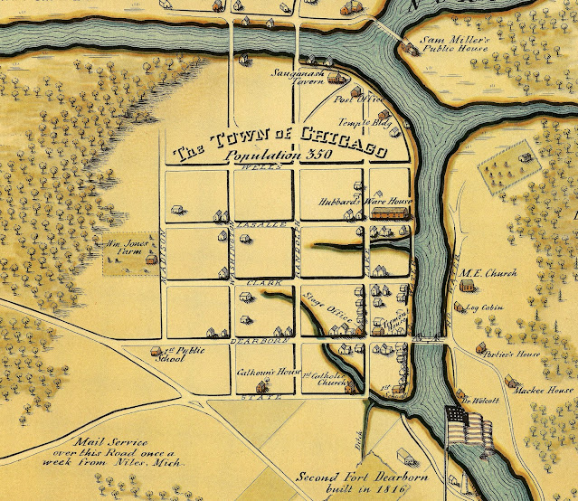
Crowley's Yacht Yard Lakeside posted
Map of Chicago looking west in 1833 when the population had reached a teeming 350.
The early Chicago River is shown with some ancient tributaries. 
For perspective, Sam Miller's Public House was located on what would later be called Wolf Point.

3

Brendon Baillod posted three images with the comment:
This amazing vintage gatefold woodcut engraving arrived this week.  It is an original two page fold-out illustration from Harper's Weekly dated June 1884 and is nearly 140 years old.
It shows a birds-eye view of an extremely busy Chicago harbor mouth and is lavishly detailed.  It gives an excellent feel for the hustle and bustle of a large early Great Lakes port, capturing the smoke, soot and general congestion of the river mouth.
There is a lot to unpack in this image, with many interesting vessels, including the sidewheeler Chicago, a fully rigged barkentine and several other interesting vessels.  The Life Saving Station is visible at the pierhead and a great deal of Chicago's early waterfront is rendered with excellent detail.
This image was too big to scan so I photographed the page, which reduced the resolution and introduced some coloration.  It was made from the top of the lighthouse at the harbor entrance and was likely adapted from an original photograph, which no longer exits.
Brendon Baillod shared
Dennis DeBruler shared

Chicago River Mouth in June 1884

When I glanced at this image, I knew it was old because:
  • black smoke was still condered a sign of prosperity
  • the Illinois Central still had both of its grain elevators
  • the Interstate Exposition Building (the one with three domes) is still standing
  • some of the ships have sails
  • the lumber trade is at the mouth rather than down by Lumber Street on the South Branch
  • there is no fill east of the IC trestle along the lakefront
  • there is a railroad bridge connecting IC and C&NW's Navy Pier line
1

2

3

Dennis DeBruler commented on his share

Brendon Baillod posted
This excellent early Chicago stereoview arrived today.  It shows a scene on the Chicago River looking east out the harbor mouth at Lake Michigan.
The card was made about 1882 and is a republication made by the Chicago stereoview publisher George F. Gates.  The original image is a bit earlier, dating from about 1880.  
[The description continues with an analysis of the schooner Mary E. Perew.
From Brendon's private collection. It is used with permission.]

Brendon Baillod posted
This imperial size stereoview card of Chicago Harbor arrived today. It was published in 1885 by Woodward Stereoscopic Company of Rochester, New York as part of their Chicago, Ill and Vicinity series.
It is titled Chicago Harbor from Lake Street Bridge and shows a harbor tug working on a large schooner with a grain elevator in the background. When I bought the view, I was pretty sure I saw a nameboard on the schooner, but unfortunately, it was just one of the scuppers. Additionally, much of the view is obscured by the tug's steam, and the exposure is also somewhat uneven.
The tug is a bit more interesting. She bears an ornate V.O.T.C on her bow, signifying the Vessel Owners Towing Company of Chicago. They owned about a dozen tugs, but only a few at Chicago during this period. Based on the date of the view, which is known with some accuracy, she might be the tug Thomas Hood, but I'd welcome other opinions.
[From Brendon's private collection. It is used with permission.]

Brendon Baillod posted
It's been a good week for new acquisitions.  This stereoview of the Chicago River arrived today.  I believe it shows the Clark Street Bridge in the distance as a tug brings a three-masted schooner up the river on the right and a large passenger steamer approaches on the left.
The card was extremely dirty when I received it with the vessels being mostly obscured.  I cleaned it gently with a damp cloth and distilled water, which removed a surprising amount of dirt and grime.  The cloth was black when I was done.
This is a view I've never seen before and appears to be a 1880s or 1890s reproduction of an earlier original as evidenced by the single panel that comprises both the left and right images.  The actual image looks to be from the 1870s.  No names are visible on the vessels but the flag on the stern of the steamer is nearly legible.
[[Image copyright © 2023 by Brendon Baillod.From Brendon's private collection. It is used with permission.]
Brendon Baillod shared
Terry Gregory: Very interesting. My GGGF was a well known Chicago Shipbuilder from 1855-1884. I’ve been researching his boats for 20 years. Here is my research (also a Chicago Historian).
https://chicagology.com/harbor/ships/
Brendon Baillod: Terry Gregory That's an excellent piece of research! Thanks for sharing. I come across John Gregory regularly in my research and have researched or own images of many of the vessels he owned. I see them regularly in vessel enrollments, news micros, USLSS Annual Reports, MVUS registers and Inland Lloyds/BLU registers.

Association for Great Lakes Maritime History posted
A repaired image from a damaged dry plate negative of the Chicago River looking east from the Rush Street Bridge, circa 1905 (Image Source: Library of Congress – Detroit Publishing Co. Collection). A high-resolution copy of the photograph shows the steamer Virginia on the right.
In the background on the right is the steamer Iowa. On the left side of the image is the schooner W. O. Goodman of Chicago. The freighter Syracuse of the “New York Central & Hudson River R.R. Line” is in the background on the left side of the river. 
In the foreground on the left is the tug Harry C. Lydon towing a barge. The wording “Chicago & Great Lakes D.&D. Co.” appears on the vessel’s bow. In the background on the right is the tug A.B. Ward which appears to have towed a barge of coal to alongside the Virginia for fueling.
[The description goes on to provide the history of the ships.]

Brendon Baillod posted
Here's a rare, early Great Lakes nautical woodcut I picked up last week.  This view of Chicago harbor dates from 1885 and was published in Frank Leslie's Illustrated Newspaper of January 16, 1886.
It shows an extremely busy Chicago harbor with a great deal of intermodal transportation.  The railyards near the waterfront were immense even in 1886, while the harbor traffic includes schooners, tugs, a sidewheel steamer (probably the Sheboygan or Muskegon) and a large number of steam dredges actively engaged in deepening the basin south of the harbor pier.
This woodcut is relatively uncommon and this is the first time I've seen it on the market.  This is a photographic view as it was too large for my scanner bed.  Thus, the uneven lighting.
[This is a digital image of an archival original in my private collection.  Please include original description if resharing on Facebook.  Please credit the Brendon Baillod Collection if you wish to share outside of Facebook.]
Brendon Baillod shared

Monday, March 27, 2023

North Damen Avenue over North Branch Chicago River

(Bridge Hunter broke Mar 22, 2023; Satellite)

Douiglas Butler posted
Source from Library of Congress North Damen Avenue Bascule Bridge was replaced crossing the North Branch Chicago River in Chicago, IL is identical to the 18th Street Bridge crossing the South Branch Chicago River.
[I searched the LoC for this photo, but I could not find it.]

It is rare for Chicago to use a single-leaf trunnion bridge.

Since the Grebe Shipyard closed, many of the bridges on the North Branch no longer need to be movable.
Street View, Jul 2019

I include this view because the building still has a smokestack.
Street View

Street View, Sep 2022