 |
| Paul Petraitis posted 11am 9/23/1905, Photo courtesy of the Metropolitan Water Reclamation District Ean Kahn-Treras We are looking off of 18th Street in this view. The elevated track is the IC iowa division curving for their crossing of the RI at 16th Street. Mark E. Vaughan Wasn’t the Erie carfloat interchange operation in this area also? Bob Lalich The Erie Lake Line had two stations, both of which were farther north. Information describing the operations can be found here: http://freepages.rootsweb.com/.../genealogy/erielakechi.html MWRD posted a darker exposure David Daruszka: The swing bridge in the background would eventually be replaced by the St. Charles. |
 |
| Bob Lalich commented on Paul's posting The bridge seen here is the SCAL swing bridge. The yard here is C&WI's 18th St Yard. 16th St Tower can be seen in the distance. Here is the smoke abatement map of the area. |
 |
| MWRD posted on Oct 30, 2022 The South Branch of the Chicago River and the rail yard for the Chicago & Western Indiana Railroad on September 5, 1905, viewed looking north from Eighteenth Street. |
At first, I thought this was the same photo as above, but then I noticed the two isolated gondola cars in the foreground.
 |
| MWRD posted The South Branch of the Chicago River and the railyard for the Chicago & Western Indiana Railroad viewed looking north from Eighteenth Street on September 16, 1905. |
Even more boats and freight cars in this view.
.jpg) |
| MWRD posted The South Branch of the Chicago River and the railyard for the Chicago & Western Indiana Railroad viewed looking north from Eighteenth Street on September 13, 1905. |
 |
| 1897 Map |
 |
| James Boudreaux posted Elevating the St. Charles Airline from Chicago Union Stations' south main line. Bottom L/S quadrant is now Amtraks' 16th St. diesel shop and yard (ex Penn Central, Pennsylvania RR). Upper R/S quadrant is Metras' yard (ex CB&Qs' Zephyr Pit) David Daruszka also posted St. Charles Airline track elevation under construction. Bob Lalich That is a beer bottle from the Schoenhofen brewery. http://forgottenchicago.com/articles/schoenhofen-brewery/ |
The title is misleading because these notes now also show the work to separate the railroads (C&WI and Santa Fe) to Dearborn Station from the other railroads (St. Charles Air Line, IC, RI and NYC) in this area.
Jon Roma posted eight images with the comment:
An earlier post by Dennis DeBruler featured a postcard view of the grade separation at 16th and Clark Streets on Chicago's near south side. In this post, I show some images of this crossing before and during grade separation. This complex at-grade crossing was once said to be the single biggest railroad bottleneck in Chicago if not in the nation. I believe there were well over a hundred crossing diamonds involved.The crossing was not interlocked, which meant that every train passing through the crossing had to make a statutory stop before being flagged onward over the crossing. With Chicago's rapid growth, the situation was not sustainable. After much wrangling, the railroads involved agreed to a grade separation wherein the Chicago & Western Indiana and Santa Fe were depressed in order to separate them from the Illinois Central (Chicago, Madison & Northern), St. Charles Air Line, and the joint Lake Shore & Michigan Southern/Chicago Rock Island & Pacific line.Work began around the beginning of 1898 and wrapped up in 1901, with the commissioning of an interlocking plant in the northwest corner of the plant. Though the grade separation and interlocking made a huge difference in the fluidity of the plant, this crossing can still cause delays. The plant is much reduced in size due to rationalization of the physical plant to meet today's needs, but is still controlled from the interlocking tower placed in service in 1901, though the building is leaning perilously due to settling caused by the construction of the CTA Orange Line subway in the early Nineties.These photographs came from the 1899 annual report of the Illinois Railroad & Warehouse Commission, and were digitized by Google, and downloaded from hathitrust.org. The halftone photos in Google's scan leaves a bit of quality to be desired, and I wonder whether the original negatives survive in the state's historical library in Springfield.I will let the photo captions speak for themselves.
 |
| 1 |
 |
| 2 |
 |
| 3 |
 |
| 4 |
 |
| 5 |
 |
| 6 |
 |
| 7 |
 |
| 8 |
An overview of the end result.
 |
| safe_image for d.w.davidson Flickr This is a view of how the elevation of the IC, St. Charles Air Line, RI and NYC put the C&WI in a trench. I've been looking for something like this for years. Starting from the left. Barely visible bridge for the IC over Santa Fe Part of the bridges for the SCAL-RI+NYC connector over Santa Fe The girders still exist: 41°51'37.1"N 87°37'53.9"W Bridge for the GM&O/Chicago & Alton connection to the SCAL and RI+NYC Bridges for SCAL over C&WI Bridges for the SCAL-RI+NYC connector over C&WI The girders still exist: 41°51'37.5"N 87°37'54.7"W Just past the left side of the connector bridges is the C&WI 16th Street Tower. In the extreme foreground is part of the bridge of the Alton connection to RI+NYC. In the background is the SCAL swing bridge because this image was before the river was straightened. Evidently Rock Island has not yet built their turntable because I think it would be visible on the otherside of the C&WI "wall." As a bonus, the grain elevators are Union, Armour F and Armour E. Seth Lakin The girders on the NYC/Rock to the SCAL over the C&WI were removed last year as part of the Wells St/Wentworth Ave connector project. The bridge over the C&WI/Grand Central connector was also removed, but replaced with a new bridge for Well/Wentworth. That’s why the SCAL has been out of service for a year. Dennis DeBruler Admin Seth Lakin I'm glad to hear that the reason the bridge has been up for many moons is not because it broke. |
 |
| David Daruska post via Historical Interlocking Dennis DeBruler commented on his post Red: Barely visible bridge for the IC over Santa Fe Yellow: Part of the bridges for the SCAL-RI+NYC connector over Santa Fe The girders still exist: 41°51'37.1"N 87°37'53.9"W Blue: Bridge for the GM&O/Chicago & Alton connection to the SCAL and RI+NYC Green: Bridges for SCAL over C&WI Light Yellow: Bridges for the SCAL-RI+NYC connector over C&WI The girders still exist: 41°51'37.5"N 87°37'54.7"W Black Rectangle: Just past the left side of the connector bridges is the C&WI 16th Street Tower. Light Blue: In the extreme foreground is part of the bridge of the Alton connection to RI+NYC. Light Green Rectangle: In the background is the SCAL swing bridge because this image was before the river was straightened. |
 |
| Comments |
 |
Pete Fileca What railroad is curving to the bottom of the picture Dennis DeBruler Admin Pete Fileca It is a connector from the Chicago & Alton (GM&O) to the RI+NYC. (NYC bought the Lake Shore & Michigan Southern.) C&A shared the embankment with the IC. (Today CN owns both those railroads, but the C&A track has been removed. The embankment still exists because that is how the IC gets from ground level at the 21st Street Crossing to the SCAL, but it is hard to find because both sides of the embankment have been filled in.) That connector forked just after it crossed the Santa Fe to also connect the C&A to the SCAL. Jon's map is accurate enough to drop a pin. First of all, I added a yellow line to highlight the C&A label along the west side of the embankment. Secondly, the photographer was standing just north of the 16th Street Tower (red dot) looking due East. This map also teaches me that this bridge also supported a RI+NYC branch to facilities south of 16th Street. Given the LS&MS label, I presume that NYC was between 16th and 18th and RI was south of RI. The spacing of the tracks reinforces my current theory that these were team tracks. I have to remind myself that this is before the river was moved and the RI had much less land north of here. This map has an error. The C&A connector to the SCAL should not stop at the RI+NYC branch. It should continue on to the SCAL. |
 |
| Andre Kristopans Santa Fe got on CWI at 21st St, about a half mile west from this spot. Lower leven is CWI to Dearborn Station, NE/SW alignment. Upper level is RI/NYC to LaSalle St on N/S alignment, being crossed by IC which merges with St Charles Air Line (CNW) on an E/W alignment. CWI long gone, everybody else still there. CTA burrows under this area in tunnel. Dennis DeBruler Admin Andre Kristopans No. This map is an excerpt from the C&EI1964ChicagoDearborn-300lg.pdf file that is in the Files section of this group. The Santa Fe+IC+C&A crossed the C&WI (and Pennsy) at the 21st St Junction and continued east. The Santa Fe soon separated from the IC+C&A and remained at ground level while the IC+C&A started up its embankment. On the north side of of the Sante Fe yards, it ducked under the IC and the SCAL-RI+NYC connector to meet the C&WI under the SCAL bridge. By this time, the bridges for the C&A-RI+NYC connector had been removed. |
 |
| Dennis DeBruler Admin When I saw the error concerning the C&A-SCAL connector in the grade separation map, it occurred to me to check a 1915 Smoke Abatement Report map. It correctly depicts the curves in the C&A connector. It also implies that the IC may have shared that connector to the RI+NYC tracks. I included a lot of the map to the south of the 16th St complex because I noticed that by 1915 RI+NYC had abandoned sharing the bridge across the C&WI in favor of accessing their freight facilities on the south end. (Actually, I now think the plans got changed and the elevated yards were never accessed from at the north end.) I also include the location of the Schoenhofen Brewery (Edelweiss Beer) because I was surprised that I could not see the beer bottle water tank in the background of Jon's photos. (Facebook did let me change the photo in this comment. So now I'm really confused as to what is happening with the "colored lines" comment.) |
 |
| Dennis DeBruler Admin While accessing the C&EI map from the files section, I noticed Timothy Pitzen's Track Elevation Plats. This is from what PDF calls page 8. This map also shows RI+NYC accessing their freight facilities on the south side. Was the access from the north on the grade separation map wrong, or was that access abandoned by 1909? This map taught me that the C&WI and Santa Fe went down in addition to SCAL, IC, C&A, RI+NYC going up. |
 |
| Dennis DeBruler Admin [I have to remember that the Library of Congress has made accessing Sanborn Maps of Chicago a lot easier than when I started this blog in 2014.] This is from Volume 3, and it has a date of 1911. |
 |
| Dennis DeBruler Admin David Daruszka also posted [Historical Interlocking] another view of this area after the elevation but before the river was moved. |
 |
| Dennis DeBruler Admin Bob Lalich provided a map [as a comment on David's post] of the area before anything was elevated with the comment: Because this crossing was such an operating nightmare, it was one of the first grade separation projects in the Chicago area. Here is a drawing from Railroad Gazette in 1891 before separation and interlocking. At the time, the crossings were protected by flagmen. Imagine the arguments and tie-ups! And notice that the St Charles Air Line was a straight alignment as built. |
 |
| Dennis DeBruler Admin David Daruszka also posted this view that looks east along the grade level SCAL. The Schoenhofen beer bottle water tank is what I was talking about in the 1915 map comment. [This photo was from these notes. See above for the original.] |
 |
| Dennis DeBruler Admin This May 1929 aerial photo of the river straightening project makes it easy to visualize how C&WI was west of the IC+C&A embankment while Santa Fe was east of it. It also shows how the embankment widened so that IC could turn west while C&A continued northwest on a skinny embankment between the two SCAL-RI+NYC bridges, goes over the Sante Fe, crosses the SCAL and then has its own bridge over the C&WI+Santa Fe. (It also appears that the Clark Street bridge over the C&WI+Santa Fe had girders between the lanes.) [via C&WI "Trench"] |
 |
Dennis DeBruler Admin David Charles Lindberg posted this photo taken from the bridge that carried IC over the Santa Fe tracks going north to join the C&WI tracks. Cameron Applegath explained: "Either deadheading from ATSF trackage (which back then would probably have been utilized for Amtrak staging and storage) to CUS or deadheading from CUS to ATSF." (I remembered that Amtrak used Santa Fe's coach yard for a while to help while they were rebuilding the Pennsy yard to their own design.) [via 16th Street (Clark) Interlocking] |

Dave Durham posted eight photos with the comment: "Track work to elevate the lines of the A.T.&S.F. and C.&W.I in the 14th/15th/16th St.and Clark area; Please adjust your travel routes and leave10-15 minutes earlier to avoid delays."
Bob Lalich Dave Durham - which site allows a free download? I have searched a few times and can only find sites that require membership.
Dave Durham Bob Lalich I have been utilizing Hathitrust
Bob Lalich Have you downloaded the entire document, or just a few pages at a time?
Dave Durham Photos, and pages...are you not able to? Are you viewing on a home computer or mobile device?
Jim Holmes Guys, I had to search for over an hour to get those documents because Haithtrust requires membership in some university to get full copies. I searched for a couple of the headings and found a link. the map above originally came from and Engineering News publ and re-referenced in the 1898 issue of Dave's publication, not the 1905. I can provide the two pdf's via email if so desired.
 |
| 1 |
 |
| 2 |
 |
| 3 |
 |
| 4 |
 |
| 5 |
 |
| 6 |
 |
| 7 |
 |
| 8 |
 |
| MWRD posted The South Branch of the Chicago River and the railyard for the Chicago & Western Indiana Railroad on September 16, 1905, viewed looking north from 18th Street. Randy James: Illinois central wooden 36' box cars in the upper right corner. Dennis DeBruler: The ship has four masts and a smokestack. 1905 is old enough to catch the transition from wind to steam. Greg Burnet shared |
 |
| Dennis DeBruler commented on Greg's share Paul Petraitis has posted a MWRD photo taken on Sep 23, 1905. |
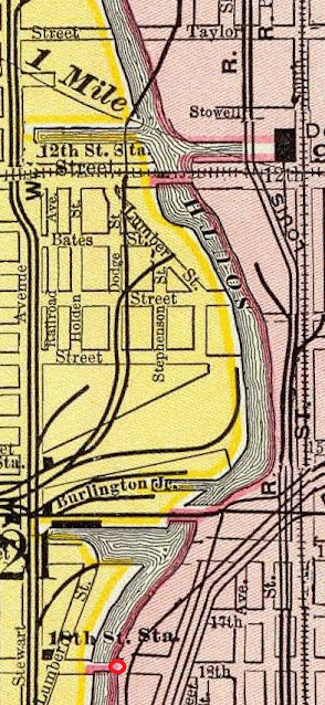 |
| Dennis DeBruler commented on Greg's share For both photos, the photographer was standing on the 18th Street Bridge (red dot) looking along the river after it bent towards the East. An unvandalized copy of this image is available here: https://industrialscenery.blogspot.com/.../st-charles-air... |
 |
| Dennis DeBruler commented on Greg's share IC: The IC Iowa Division going from the 22nd Crossing to the overpass over the Rock Island and NYC tracks. 16: C&WI 16th Street Tower: https://industrialscenery.blogspot.com/.../c-16th-street... W: it appears that quite a few workers doing some track work. SC: St. Charles bridge before the tracks were elevated: https://industrialscenery.blogspot.com/.../st-charles-air... E, F & U: Armour E&F and Union grain elevators: https://industrialscenery.blogspot.com/.../union-and... |
 |
| Dennis DeBruler commented on Greg's share Everything in these photos, including part of the river, is gone except for the IC tracks, and they are now owned by CN. The IC tracks are on the other side of the tree line on the right side of this image. The C&WI yard was replaced by Ping Tom Memorial Park. |
 |
| Dennis DeBruler commented on Greg's share When they made that park, they added a lot of fill, especially on the east of the tracks, so that the tracks now appear to be at ground level rather than on an embankment. You can still see the top of the embankment wall peaking above the fill. |