Showing posts with label rrAmtrak. Show all posts

Friday, October 11, 2024

Amtrak Bush River SUC Bridge at Perryman, MD

(Archived Bridge Hunter was broke, no Historic Bridges; Satellite, 61 photos)

 
Douglas Butler posted
This Railroad Bascule Bridge is a Strauss Type located in Perryman, MD crossing the Bush River used by Amtrak and Northeast Corridor source: Tidal Fish.
Douglas Butler: Dennis DeBruler This is a Strauss Underneath Counterweight Bascule Bridge with a curved rack.

Douglas commented on his post
The Bridge in the Lowered position

Douglas commented on his post
This is the Patent of this bridge

Wednesday, January 17, 2024

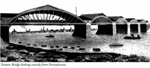
1903 Stone Arch Bridge and 1806+1928,1997 Truss Bridges over Delaware River at Trenton, NJ

Amtrak/Pennsy Stone Arch Bridge: (Bridge Hunter broke Mar 22, 2023; Historic BridgesSatellite)
Lower Trenton Bridge: (Bridge Hunter broke Mar 22, 2023; Historic BridgesSatellite)
The Lower Trenton Bridge carries Bridge Street, which was part of the historic Lincoln Highway.

Street View, Nov 2022

Street View, Nov 2018

Street View, Jul 2023

The sign reads: "TRENTON MAKES     THE WORLD TAKES."
Street View, Jul 2018

It is nice to see a truss bridge that is well maintained. HistoricBridges explains: "This bridge is owned by the Delaware River Joint Toll Bridge Commission (DRJTBC). The DRJTBC has a unique commitment to maintaining the many historic bridges under its ownership, and working with the communities the bridges serve, and sets an example for the rest of the country to follow. The front page of their website often features a photo of a historic bridge, and their slogan is Preserving Our Past, Enhancing Our Future."
Street View, Nov 2022

River Rail Photo posted
EMDs On The Delaware. NJ TRANSIT is shifting its preparations into high gear for the upcoming 40th Anniversary events. On the afternoon of Wednesday, September 27, 2023, NJTR GP40PH-2 4108 brought Juniata Terminal Company's famed former Pennsylvania Railroad E8 5711, the "120", and the Warrior Ridge/1157 to the Meadows Maintenance Complex, seen crossing the 1903 stone arch bridge over the Delaware River from Morrisville, Pennsylvania to Trenton, New Jersey with the famous sign in the background. While the cars will be part of Saturday's excursion, the E8 will only be displayed on Sunday.
Flickr: https://flic.kr/p/2p5KvTT

Steven J. Brown posted
Amtrak AEM7 949 (built 1988) crosses the Delaware River in Trenton, New Jersey - March 3, 2003.
Steven J. Brown posted
Amtrak Acela Regional with AEM7 949 (built 1988, scrapped 2018) crosses the Delaware River at Morrisville, Pennsylvania - March 3, 2003. (Trenton NJ)
Steven J. Brown shared
David P. Reaves III: Must be low tide? Or is the Delaware tidal here?
Richard Jahn: David P. Reaves III - not tidal here. Low water flow

Bill Mennel posted
MP54 on Delaware River Bridge at Trenton NJ
 
John Brady posted
Railroad bridge across the Delaware River at Trenton.

drjtbc
 
Bridges Now and Then posted
The Lower Trenton Bridge, crossing the Delaware River between Trenton, New Jersey, and Morrisville, Pennsylvania. (Trenton Daily)

Paul Osciak posted two photos with the comment: "The 'Trenton Makes' Bridge with a very high Delaware River after heavy rain in Trenton NJ."
Art Suckewer: The center of the abutments and piers are original to the first bridge crossing the Delaware made by Burr; their construction dating to 1804-06. If you look when the water is lower, you can see the various expansions, including when the PRR trains (precursor to the Northeast Corridor) crossed it alongside the roadway.
1

2

Some of the substructure dates back to 1806. [HistoricBridges]
Historic Bridges Article

Friday, October 27, 2023

1913 Amtrak/New Haven Bridge over Shaws Cove in New London, CT

(Bridge Hunter broke Mar 22, 2023; HAERSatellite)

HAER CONN,6-NEWLO,12-
1. VIEW, LOOKING WEST, SHOWING BRIDGE IN CLOSED POSITION - New York, New Haven & Hartford Railroad, Shaw's Cove Bridge, Spanning Shaw's Cove, New London, New London County, CT Photos from Survey HAER CT-24

Since the bridge is low ("3 feet at mean high water and 6 feet at mean low water" [FederalRegister_shaw]), it must open quite frequently in the non-Winter months when the marina in Shaw Cove is full.
In fact, it sounds like they will stop an Amtrak train for a recreatoinal boat to ensure a maximum delay of 10 minutes from 5am to 10pm during the months of Apr-Nov. [FederalRegister_regulations]
The horizontal clerance is 70'. [WaterwayGuide]

HAER CONN,6-NEWLO,12-
9. PORTAL ELEVATION DETAIL WITH BRIDGE IN OPEN POSITION

Significance: "The Shaw's Cove Bridge is a forged steel rim-bearing swing bridge. It is a single-span, pin-connected Pratt through truss with thin diagonal eye-bars serving as tension members. It is significant as part of the transportation link in the shoreline route of the New York, New Haven and Hartford Railroad, and as an individual engineering solution to the need to provide dependable rail service while accommodating river navigation." There have been plans to replace it since at least 1983. I wonder what the clearance of the new bridge would be.  [HAER_data]

River Rail Photo posted
Sticker Cars. On the afternoon of Sunday October 8, 2023, Kawasaki built M8 9365 led Shore Line East Train 3645, seen crossing Shaw's Cove in New London, Connecticut on the way to New Haven, Connecticut. Of the more than 500 M8s purchased by MTA Metro-North Railroad and the Connecticut Department of Transportation, generally 12 are assigned to Shore Line East Service since May of 2022. These cars have their third rail shoes removed for clearance purposes and recently have had a "CT Rail - Shore Line East" sticker placed over the Metro-North logo.
[This train had just crossed the Thames River Bridge.]
Doug Kendall: Nice touch catching the Orient Point ferry coming in at right...
Phill Inokeechobeefl: Doug Kendall Actually called the Cross Sound Ferry I was on one of them every Friday and Sunday for years going to Orient to work on a Lobster boat from there.

River Rail Photo posted
Acela 2 Over The Cove. On March 1, 2024, Amtrak/Alstom Acela 2 Train Set 8 crossed Shaw's Cove in New London, Connecticut while operating as non-revenue train 846. On Thursday, August 28, 2025, long-awaited revenue service will commence with this model on the Northeast Corridor Line between Boston, Massachusetts and Washington D.C. The train brings some increased speed to the trip, but also adds much needed capacity. Though it will begin with a pair of weekday roundtrips, eventually 28 train sets will enter service.
Full resolution pics and prints: https://www.riverrailphoto.com/amtrak/e400a9caf

The Cross Sound Ferry is a shortcut to Long Island.
Satellite

Flickr photo

1:03 video, it is a looooong Amtrak train.


Wednesday, January 11, 2023

1922 Road Bascule and NYNH&H Swing Bridges over Mystic River in Mystic, CT

Bascule: (Bridge Hunter; Historic Bridges; HAERSatellite, 618 photos; Satellite, 136 photos)
1919 Swing: (Archived Bridge Hunter, HAER)
1982 Swing: (Archived Bridge Hunter; no Historic Bridges; Satellite, 73 photos)

NYNH&H = New York, New Haven & Hartford

Boston Public Library Flickr via BridgeHunter, License: Creative Commons Attribution (CC BY)

HAER CONN,6-GROT,2--1, cropped
1. VIEW NORTH, GENERAL VIEW OF BRIDGE WITHIN SETTING - Mystic River Bridge, Spanning Mystic River at U.S. Route 1, Groton, New London County, CT

HAER-data
Thomas E. Brown patented this balance beam bascule, and J. A. L. Waddell was the consulting engineer. Brown also designed elevators and funiculars. Of note is that Brown designed the inclined elevators for the Eiffel Tower in 1888 and 1889.

I couldn't resist including part of the Mystic Drawbridge Ice Cream Cafe.
Street View, Aug 2022

Street View, Aug 2022

safe_image for a registration restricted link
“Opened on July 19, 1922, the unique bridge has connected the residents of Groton and Stonington for 100 years and attracted visitors from all over.”

I noticed in the second street view that it uses an unusual lift mechanism. Fortunately, the HAER caught that detail. Instead of using a rack that is on the frame of the bridge, this one uses an "operating wheel" and a link.
HAER CONN,6-GROT,2--10
10. VIEW NORTH, DETAIL OF OPERATING WHEEL AND LINK, NORTH SIDE, BRIDGE CLOSED

HAER CONN,6-GROT,2--11
11. VIEW NORTH, DETAIL OF OPERATING WHEEL AND LINK, NORTH SIDE, BRIDGE OPEN

Rhvanwinkle at en.wikipedia, CC BY 3.0, via Wikimedia Commons

This bridge was proceeded by a 1904 swing bridge, an 1866 Truesdell truss swing bridge and an 1854 draw bridge.

Jim Streeter, the Groton Town historian, notes that there were eight other bridges that previously crossed the river. Some of those bridges were temporary bridges that were used while the next permanent bridge was built. The first ferry service was started in 1660 where I-95 now crosses the river. This "bridge is approximately 220 feet long and 45 feet wide, including pedestrian sidewalks on each side of the span. The lift span is approximately 88 feet long and weighs 660 tons. It has two concrete-filled counterweights, each weighing 230 tons." Two phases of rehabilitation were done in 2000-04 and 2010-13. [TheDay]

HistoricBridges has a photo of this bridge in the raised position and photos of the 1904 and 1866 bridges.

MysticHistory has many more photos including some construction photos.
.

Swing Bridges


1982:
Drew Al posted
Mystic River Railroad Bridge, Mystic Connecticut

1919:
HAER CONN,6-GROT,1--1
 1. VIEW, LOOKING EAST, SHOWING BRIDGE CLOSED - New York, New Haven & Hartford Railroad, Mystic River Bridge, Spanning Mystic River between Groton & Stonington, Groton, New London County, CT

HAER CONN,6-GROT,1--5
5. DETAIL OF CENTER PIVOT

HAER CONN,6-GROT,1--3
3. DETAIL OF RACK AND TRACK [PINION] MECHANISM

The control house includes the signaling equipment for the railroad.
HAER CONN,6-GROT,1--13
13. INTERIOR, OPERATOR'S HOUSE, ELECTRO-MECHANICAL INTERLOCKING MACHINE 

I was surprised that a swing bridge wasn't replaced by a lift bridge in the 1980s. But Drew's photo and satellite images show that the boat traffic is pleasure boats and there are no huge yachts. But there are sailing ships. Unlike commercial traffic, sailing ships are more concerned about height than width. I did find some bigger boats at a couple of museums, but they were not very wide. And some of them are also sailing ships, so a lift bridge would have required tall towers.
Satellite

Thursday, June 30, 2022

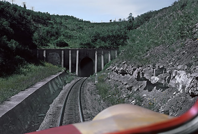
1879+1908 (BNSF+Amtrak)/Santa Fe Raton Pass Tunnel

East Portal: (Satellite, just south of the NM-CO border)
West Portal: (Bridge HunterSatellite)


"Built 1879; second tunnel built 1908; original bore closed 1953." [BridgeHunter] It is the highest point on the Sante Fe at 7588' [UncoverColorado]

The Santa Fe and Denver & Rio Grande Western not only fought for the route through the Royal Gorge, they fought for this pass from Colorado to New Mexico. This was the Santa Fe's original route to California. But it has grades as high as 4% in Colorado. Santa Fe completed the 200+ mile Belen Cutoff in 1907, which has easier grades and is more direct. The now closed 1879 tunnel was 2,041' long. The 1908 bore was 2,787' with an approach grade of 0.158% instead of the 1.9% grade for the original bore. [american-rails] Since BNSF has moved its through freight operations to the cutoff, it doesn't want to maintain this route for passenger speeds. But, of course, Amtrak does want BNSF to maintain it. That is why I added the Amtrak label to these notes.

Bob Chaparro posted
Raton Tunnel
A post by David Dickinson on the Facebook Railroad Postcards group.
He comments:
Wording on the back of the post card: "Raton Tunnel, the highest point on the Santa Fe, has an altitude of 7,622 feet.  The tunnel is 15 miles beyond Trinidad.  The Santa Fe has recently completed a second tunnel considerably below the original tunnel." Notice the cattle drive happening on the right.  Published for Fred Harvey by the Detroit Publishing Company.
Built 1879; second tunnel built 1908; original bore closed 1953.
Bob Chaparro
Hemet, CA

East Portal:
Marty Bernard posted
Raton Tunnel East Portal, Cab View
ATSF's Raton tunnel through Raton Pass, east portal, taken from cab of F7 309L pulling Train #23, the 𝘎𝘳𝘢𝘯𝘥 𝘊𝘢𝘯𝘺𝘰𝘯 near Wooten, Colorado (Colorado State Line marker) on August 19, 1967. Roger Puta photograph
Erich Houchens: I worked the Raton Desk (DS18) for five years 2012 to 2017. Still kicking myself for not taking a Road Trip and riding the headend of A3 and A4 over the pass. Of course the FRA rule against using cameras/cell phones on the headend would have prevented me from getting the same picture.

West Portal:
Hinge of fate, CC BY-SA 3.0, via Wikimedia Commons

Back when the original bore was still being used.
1929 CarterMuseum, Public Domain

A very different colorization.
Illinois Central Railroad Scrapbook posted
This postcard specifies an altitude of 7,622'.

american-rails
An A-B-B-A set of Santa Fe F3's have the "Super Chief" on Raton Pass in a publicity photo dated September 7, 1959. Roger Plummer photo.


Saturday, December 18, 2021

1910 Amtrak/Pennsy North (Hudson) River Tunnel

(Satellite, west portal)

The completion date and correct name for the title were found here.
 
The Marine Buff posted
The Pennsylvania tunnel project in New York City, initiated in 1904, marked a significant engineering endeavor by the Pennsylvania Railroad. The project aimed to establish a terminal station on Manhattan Island, linking it with the Long Island Railroad system. Construction involved clearing buildings on four large city blocks for the passenger station. Tunneling operations began with the sinking of shafts, soon extending from New Jersey to Long Island. The tunnel design emphasized safety, incorporating concrete-filled sides up to car window level to minimize damage from derailments and collisions. Electric cables were embedded in the concrete side benches, and the tunnel featured thorough lighting and refuge niches for employees. This extensive work laid the foundation for what would become a crucial infrastructure component in New York City's transit system.

safe_image for Clock is ticking for 110-year-old Hudson River rail tunnel
Superstorm Sandy flooded the tunnel with saltwater in 2012.

I learned about the Gateway Project for rebuilding rail access to Manhattan from when I studied the replacement of the Portal Bridge. By delaying the construction of a new tunnel, we (taxpayers) now need to pay for repairs on the old tunnel as well as building a new tunnel.

Trump remembered his campaign promise concerning a wall at the Mexico border but forgot his promise about fixing our infrastructer. I wish it had been the other way around.

I was aware that there was a funding issue. I was not aware that the US Army Corps of Engineers was delaying an approval.
safe_image for Project to fix critical Northeast Corridor choke point gets go-ahead

8:11 video: since 2014, needed repairs have caused 65,000 minutes (45 days) of delays (commuter cancellations) and 20% of the nations GDP gets put on hold. The new tunnels are expected to take 7 years to build, and then fixing the existing tunnels would be another 3 years.
The Gateway Project:
Screenshot @ 3:12
(Portal North Bridge)


What may have been.
Fred Hadley posted
The new bridge over the Hudson River New York in 1896
We present a perspective view of the proposed New York and New Jersey railroad bridge across the Hudson River. It shows also the New York approaches and the location of the grand terminal station. The station will be at the corner of Eighth Avenue, Forty-ninth and Fifty-first Streets.
The six track viaduct will run thence west to the block in Fiftieth Street between Tenth and Eleventh Avenues. There, by a broad curve, the viaduct will sweep northward., constantly rising at a grade of thirty-five feet to the mile.
The structure will curve to the westward again at Fifty-eighth Street, and at Fifty-ninth Street and Twelfth Avenue it will reach the end of the bridge structure proper.
The imposing proportions of the bridge and the beauty of its designs are shown in the illustration, and, when we study its dimensions in detail, it is perhaps safe to say that it will be the greatest engineering work ever attempted. This can best be understood by reference to the present Brooklyn Bridge. The main span of the new bridge will be more than twice the length and its towers fully twice the height of those
of the Brooklvn Bridge.
It was originally proposed to erect a bridge of the cantilever system, with a river span of 2,000 feet. This would have necessitated a tower 1,000 feet out in midstream, and, as the War Office requirements demanded that the river navigation should be unobstructed, it was determined by the company to attempt the bridging of the Hudson River by a mammoth suspension bridge, with a great central span of 3254 feet. 
There will be six railroad tracks, and the bridge is to be strong enough to carry all the tracks loaded with trains from end to end, or a total live load of about 30,000 tons.
It is estimated that the bridge itself will cost $25 million and the cost of the whole, bridge, approaches and terminal works, will be about $60 million. Should there be no legal or other obstructions, it is estimated that the work can be completed in eight years.
The design illustrated was made by the Union Bridge Company, of New York City. Like other Hudson crossing proposals, this one was never built. 
Scientific American excerpt and engraving, May 2, 1896

2022 Update: It looks like the route of the new Hudson River Tunnel has changed since 2014. The cost is now estimated at $11.6b. I have seen some headlines that indicate funding has finally been approved.
NewYorkIMBY

safe_image for Amtrak leverages weekend service outages to make critical repairs in North River Tunnel

5:42 video  Dec 2023 cost estimate: $17,180,000,000. Digging starts in 2025 with an expected completion in 2035.

8:04 video @ 1:50
"New York’s $29.5BN Mega-Tunnel"
3:07   The Hudson Tunnel part of the project is $12.4b.

This 10:43 video specifies a $16b cost. If you want to skip the usual "this route is important and at capacity" verbiage, then go to 2:18.

Feb 29, 2024
RailwayAge, cropped (source)

rtands

Weeks Marine, Inc. posted two photos with the comment:
If you’re near the Hudson River in New York or New Jersey, you’ve probably noticed the ongoing work on the Hudson River Ground Stabilization – the first major phase of the Hudson Tunnel Project.
We’re actively working on the Hudson, plunging 140-foot-long steel pipe piles and sheeting into the riverbed to create a stabilized foundation to facilitate future tunneling construction by other contractors. To do this, our team is constructing a temporary cofferdam containment structure to make ground improvements inside. The cofferdam is built in segments 110 feet wide and up to 600 feet long across a 1,200-foot-long corridor. This operation will continue for the next two years and is essential for preparing the ground for the tunnel boring machine and protecting the riverbed from disruption.
Once the project is complete, it will provide long-term reliability and resiliency, benefiting not only NJ Transit and Amtrak users but also travelers throughout the region and nation.

M V Boyce Boyce: Probably be using a Earth, balance tunnel, boring machine set up for a mixed face, which means it will be set up for rock and soft ground and use compressed air. [I was not aware that two years of work is needed before they can use a TBM.]
Kiewit Corporation posted the same information because Weeks Marine, Inc is one of their subsidiaries.
Michael John Hackmer: Is this for a future rail tunnel or auto or both that is planned? Or is it just in case they want to build another tunnel?
Dennis DeBruler: Michael John Hackmer It is for a rail tunnel. I've seen a cost estimate of $30 billion dollars for this Gateway Project. https://www.rtands.com/.../hudson-tunnel-project-ramping-up/
Parth Patel: Dennis DeBruler that's simply not true. It is 16 billion dollars.
Dennis DeBruler: Parth Patel $16b would be just the Hudson Tunnel. The Gateway Program includes additional construction such as the Portal Bridges and refurbishing the old tunnels. And that cost is $29.5. https://www.youtube.com/watch?v=ZMWzTbX2emI
Richard Koch: Dennis DeBruler It’s water over the riverbed now, but all of this would have been finished nearly 10 years ago if Chris Christie hadn’t pulled the plug on the earlier effort when he was elected Governor of NJ in 2009. He gave up $13B plus in federal support so that NJ wouldn’t have to raise fuel taxes for the first time in 15 years to cover the other estimated $2B. That $15B would have covered the supporting infrastructure, not just the tunnel.
1

2

BulletTrains USA.com posted eight images with the comment:
DEVELOPMENT UPDATE: The Hudson Tunnel Project
“The Hudson Tunnel Project involves construction of a new Hudson River rail tunnel serving New York Penn Station and the rehabilitation of the existing Sandy-damaged North River Tunnel.
The high level of traffic in the existing North River Tunnel — approximately 450 trains per weekday — means that without this project, taking one of the North River Tunnel tubes out of service for necessary repairs would severely reduce rail service because the remaining tube would have to accommodate two-way traffic. This very significant reduction in capacity would have a devastating effect on New York and New Jersey commuters who cross the Hudson on a daily basis, Amtrak passengers, and the regional and national economies.”
Some photos source NYC Subway Life
BulletTrains USA.com shared
1

2

3

4

5

6

7

8