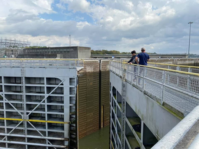
The organizers of the effort to build the plant searched for years before they found someone willing to attempt the project---Hugh L. Cooper, the engineer who had supervised the construction of the Niagara Falls plant. Since the customers they secured contracts with before they started construction were in St. Louis, the project was also the first to use high-voltage transformers and transmission towers. The Army Corps of Engineers received the lock for the 6-foot (9-foot?) navigation project as a condition of the original construction permit.
When the powerhouse was built during 1910-13, the $25 million
project was the largest privately funded construction project in the
world. People came from all around the world to witness the construction and the town became known internationally.
It was the second largest
dam, the largest monolithic concrete dam, the largest hydroelectric
power plant with the largest cast iron turbines. (I'm still trying to
determine if the largest hydroelectric power plant would also have been the
largest power plant.) For comparison, the 1885 Niagara Power Station had
10 AC generators, each rated at 5,000 horsepower (3,700 kw)
or 50,000 horsepower. The Keokuk Power Station was rated at 250,000
horsepower and 142MW. Each unit can do 10MW, but there must be switching
equipment limitations that limit the plants capacity to 142 instead of
15*10=150.
But when the plant was opened for
the 100th anniversary tour, a sign shows 150,000 horsepower and 150MW. The sign is obviously wrong because the horsepower should be more than the KW.
I hate it when websites break their links.
 |
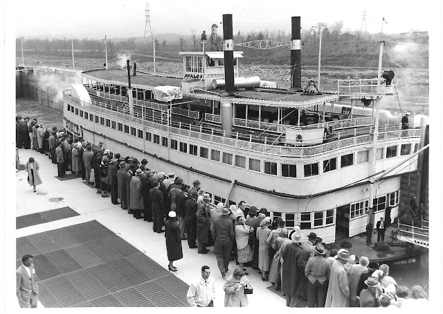
Tim Ice posted
Keokuk IA. A government photo of Lock & Dam #19, the largest on the Mississippi River.
Jim Colyer: Do any of the dams on the river generate electricity?
Tim Ice: Jim, looking at this picture top to bottom: at top is the Illinois shore. The 119-spillway dam stretches across the Mississippi to the Iowa shore to the only hydroelectric power plant on the river.. 15 generators with 2 house generators. Further to the Iowa shore is the lock complex. Built in 1913.
To the right is the Keokuk-Hamilton (Illinois) bridge, since superseded by a 4-lane non-swing span bridge.
The original plant called for 30 generators, but during construction they found the flow of the river could only handle half that. Consequently only 15 generators were completed. |
The oldest hi-res topo map that I could find was 1964. The canal around the Des Moines Rapids would be long gone.
 |
James Long posted
THE LOWER LOCK OF THE DES MOINES RAPIDS CANAL AT THE KEOKUK RIVERFRONT Many years before the construction of the current dam at Keokuk, river navigation between Montrose & Keokuk was hampered by what was known as the Des Moines Rapids. The city of Keokuk was built mainly on the business of LITERING OF BOATS travelling between St. Louis to St. Paul. Because of the Des Moines Rapids at this location, boats travelling upstream were forced to stop at the port of Keokuk to unload cargo to lighten the boat, the cargo was taken upriver to Montrose by road & the boat, sans passengers & cargo, was then safely able to navigate the rapids slowly. At times this process could take several days, therefore Keokuk needed several hotels to house layover passengers, its stores and restaurants thrived from the business of these passengers. In its heyday before the canal was built Keokuk was considered the most important port between St. Louis & St. Paul. Because Montrose was smaller, and boats coming downstream from St. Paul had to undergo this same process, most of those passengers also opted to come to Keokuk to await the arrival of and reloading of the boats at the Keokuk landing For many years, the 12 miles of rapids at Keokuk, Iowa, were the northern head of navigation. At high water the rapids were dangerous. At low water, they were impassible. Cargo headed up river or down river had to be unloaded from the boats and carried past the rapids in horse-drawn wagons. The US Army started to clear the Mississippi River as early as 1829. Lieutenant Robert E. Lee ran a project from 1831 to 1833 to remove snags and blast the largest rocks in the rapids. While this made running the rapids a little less risky, it did not solve the problem. A canal would be the solution, but that would have to wait until after the Civil War was settled. The Canal envisioned by Lee was approved and construction started in 1866. The canal was built along the west bank of the river. Starting at Keokuk, a w |
HydroWorld[1] has summarized the "firsts" for hydroelectricity:
- Longest monolithic concrete dam;
- Largest privately-funded hydropower construction project;
- Largest turbines ever constructed;
- Heaviest rotating weight suspended on a single bearing;
- Largest penstocks;
- Largest inland dry dock;
- Only pneumatically-raised lock gate;
- Only commercial hydroelectric facility on the Mississippi River;
- First long-distance transmission line;
- First high-voltage transformers; and
- First high-voltage insulators.
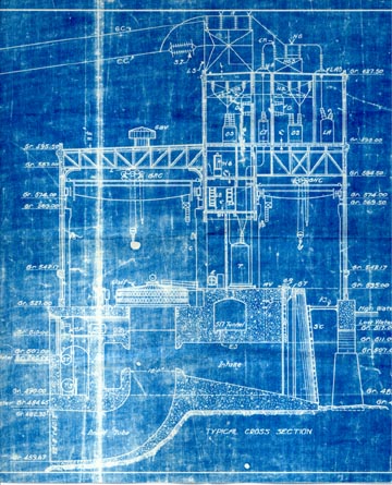
Another notable feature of the plant - the generator rotor, turbine and
shaft assemblies - may be the largest ever built. A single bearing that
was four times larger than anything built previously supports each
assembly. Engineers were uncertain a scale-up of the roller bearing
would be adequate to provide the desired service life for the system.
Only half of the turbines were installed with roller bearings. The
others were installed using a new type of bearing that had just been
invented by Kingsbury Thrust Bearings. These new bearings were so
effective that they replaced all of the roller bearings at the plant
within the following decade. After a century of virtually continuous
operation, none has needed more than minimal repair.
[1]
Five photos that Lisa Ruble added as comments.
Between Nauvoo, IL, and Keokuk, Iowa, was the Des Moines rapids. The 11-mile stretch of river that falls 22 feet (28 feet in a different source) was the first major obstruction to travel on the Mississippi river. This drop in elevation provides much of the 38 foot head (distance between upper and lower pools of water) for the power station. See
a St. Louis Post-Dispatch article for a photo by David Carson of one of the cast iron Francis water wheels that has been retired. (Starting in 2001 the turbines are being replaced with more efficient stainless steel turbines.[1]) This turbine was designed to use a small head but with a high flow rate as opposed to the type of turbine that is used in, say, the Hoover Dam. That article also has a picture of the 15 generators. (Use the arrow in the upper-right corner of the photo to access the other photos.)
 |
| Reference link has broken |
Comparing David's photo in the Post-Dispatch article of the generator room with an historical photo shows that most of the manual controls are still in place, but they are no longer used. All of the electrical components of the plant have been replaced, but most of the mechanical and civil-engineering components are of the original design, if not fabrication.
The electrical changes include switching from 25 Hertz power to 60 Hertz and using computer-based controls. But much of the 110,000 volt transmission equipment that was developed for this project is still in use[1]. The highest voltage used by the Niagara project was 20kV.
The current use of the hydro power is as a peaking plant because a generating unit can be brought on line in a matter of minutes. Basically, open a gate and sync it to the grid. This allows the plant to be used when one of Ameren Missouri's baseline nuclear or fossil fuel plants has an unexpected outage or during "peak" periods of electrical demands.
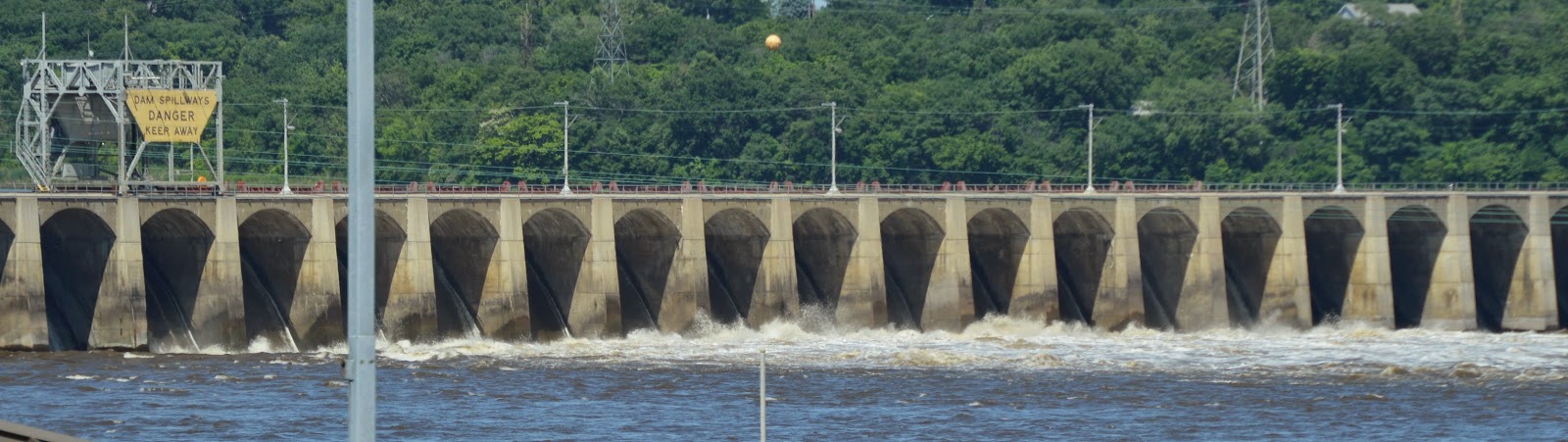
Every arch in the dam had a spillway sluice gate. It has been rainy enough this summer that some of the gates are open. A close up indicates that they have several gates open a little bit.
Other photos I have seen of the dam seem to use just a few gates that are opened wider.
I wonder if they opened the gates wider than normal to get a publicity shot for their 100th anniversary of operation. Many of the photos don't have any gates open at all because the locking operations and powerhouse can handle the river's flow. In fact, each day the Army Corps of Engineers notifies Ameren Missouri how many of the 15 turbines that they can run that day.
I learned that the Iowa side has the wrong angle to see the gates at the top of the spillway. The next time I go, I'm going to have to explore the Montebello State Park because it has
a better view of the dam's arches. But it is still hard to see the gate itself. And then I found a closeup of a single arch in the Google image collection.
I think the flow in this case is just leakage. The dam is 29 feet wide at the top, 42 feet wide at the bottom, 53 feet high, and 4460 feet long. The spillways are 32 feet high. There are 119 piers. Originally just the piers and arch were built to create a bridge. This minimized the pressure on the next cofferdam for the next pier. Then the spillways were added under the arches 5 feet at a time.
http://alongthemississippi.org/2013/08/07/how-to-be-alone-2/
Impacts of the raised water level
Raising the level of the Mississippi River to create a 60-mile-long lake
posed problems along the Iowa shoreline. The company wound up buying
out almost half of three towns and moving the residents higher up on the
bluff. Another challenge was raising the elevation of nearly 14 miles
of track that belonged to the Chicago, Burlington and Quincy Railroad
and ran along the Iowa river bank.[1]
The upper pool is 50% full of sediment. The sediment accumulation destroyed mussel beds that were upstream of the dam. This in turn destroyed the perl button business along the river. Actually, perl button is a misnomer. The buttons were made by punching them out of the shells.[2, page 26]
References:
1)
Induction into the HydroWorld Hall of Fame in 2013.
2)
Keokuk and the Great Dam, John E. Hallwas, Arcadia Publishing, 2001.
Update: Keokuk, Iowa Historians
posted 25 aerial photos of the 1965 flood. I highlight the first one and another one that has a roundhouse.
 |
| a |
 |
| b |