Showing posts with label rrBig4. Show all posts

Monday, March 30, 2026

Broke Aban/Big Four/Peoria & Eastern Bridge over West Fork Sugar Creek west of Danvers, IL

(no Bridge Hunter; no Historic Bridges; Satellite)

Abandoned Illinois Railroad Bridges posted five photos with the comment:
The bridge failure that put a rail line permanently out of service:  This unique double-arch concrete culvert carried the Peoria and Eastern railway (Later New York Central, then Conrail) over the West Fork of Sugar Creek.  It is located just west of Danvers in rural McLean county.  It is clear from the attempted repair/bracing of this bridge using lengths of rail bolted to its sides above the arches, that it was known to be in danger of failure.  This bracing was not enough to prevent it's partial collapse, however.  Heavy rainfall in early December 1982 caused massive flooding in Central Illinois and resulted in the wash-out of the center support of this bridge.  Late in the evening on December 2nd, a Conrail freight train derailed while attempting to cross this washed out bridge, likely damaging it beyond repair.  This put the section of the P+E between Pekin and Deere permanently out of service, never to be used again.  
Massive thanks to legendary central Illinois railfan David Jordan for assistance in gathering the historical information about this incident!
1

2

3

4

5

1930/30 Danvers Quad @ 62,500

Saturday, December 13, 2025

1901 Aban/Big Four/Peoria & Eastern Stone Arch Overpass near Batestown, IL

(Satellite)

Satolli Glassmeyer posted
Historic 1901 Stone Arch Tunnel in Vermilion County, Illinois. 
To have your historic site featured on our YouTube Channel, contact me.
Michael Roegner: That seldom used road used to be the main road, which is why it warranted an elaborate tunnel. Strip mining to the north reduced it's importance and it just became an access road to the houses along the road.

This shows how the creek passed through the tunnel.
6:14 video @ 1:11

Friday, June 6, 2025

Big Four and Erie Bridges over Olentangy River in Caledonia, OH

Big Four: (Archived Bridge Hunter; Bridge Hunter; Historic BridgesSatellite, the southern bridge)

Street View, Sep 2023

Bill Edrington posted three photo with the comment:
The through truss bridges of the Big Four (right) and the Erie (left) still stand side-by-side over the Olentangy River at Caledonia, Ohio.  The two railroads operated their parallel lines as joint double track (dispatched by the Erie/EL) between Burt (Galion) and Marion for many years.  Both tracks became Conrail property on April 1, 1976, and CR eventually single-tracked the line, removing most of the Erie main, as seen here.  This is officially CSX's Mount Victory Subdivision today, but to me, it'll always be the Bee Line.
Bruce Bridges: The only truss bridge on the entire route from Cleveland to St. Louis! Everything else is concrete arches or deck plate girders.
Bill Edrington: Bruce Bridges - You're right, at least since the time of the PC merger in 1968, when the ex-PRR was designated as the main line west of Terre Haute. The Big Four's Cleveland-St. Louis main via Mattoon and Pana did have two other through truss bridges in modern times, over the Wabash River at Terre Haute and over Cahokia Creek near Gard, Illinois. Both still exist; the former is now used by the Decatur & Eastern Illinois; the latter by the UP's Pana Subdivision.
1

2

3

HistoricBridges_Erie
This lattice truss is a "quadruple instersection Warren truss." [HistoricBridges_Big_Four]

Dennis Born posted
The double lines into Marion oh.  Former EL lines on the left  😮‍💨 ,   current CSX on the right.

Dennis Born commented on his post
Forgot this one in Caledonia, the CSX main looking east to Galion.


Sunday, July 7, 2024

CSX+(NS+IORY) Bridge over Great Miami River in Dayton, OH

(Archived Bridge Hunter; no Historic Bridges; Satellite)

The bridge is 675' (206m) long with a max span of 225' (69m). [BridgeHunter]

Jann Mayer via BridgeHunter, License: Creative Commons Attribution (CC BY)

River View, Sep 2016

The tracks are at the top of the levees so they don't have to worry about flood walls.
Street View, Jun 2022

J.B. Rail Photog posted
06/27/2024 - CSX M277-25 heads southbound on the CSX Toledo Subdivision through Dayton, OH, crossing the Miami River.  This is an interesting bridge because CSX and Norfolk Southern actually uses the same bridge with on their own trackage.
[The northern track is CSX/B&O, and the southern track is NS/Big4. According to the 2004 SPV Map, IORY also uses the Big4 track.]
J.B. Rail Photog shared

Brian Caswell Train Photography posted
A Norfolk Southern mixed freight train crosses the Miami River in downtown Dayton Ohio at sunset / 7-14-25

Craig Hensley Photography posted
A pair of CSX units pull an eastbound ethanol train over The Great Miami River as they head into downtown Dayton, OH.
Dayton, OH - July 2024

Monday, March 6, 2023

CSX/Big Four Bridge over Scioto River at La Rue, OH and Mar 2023 Flooding

(no Bridge Hunter; Satellite)

Street View, Jul 2014

Why am I noting a steel girder bridge that is so plain that Bridge Hunter hasn't documented it? Because the river is flooding. I wonder how much of the field that is out-of-frame to the left is under water.
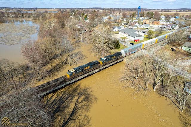
MP Rail Photography posted
A CSX Autorack train heads westbound over a flooded Scioto River in La Rue, Ohio on the CSX Mt. Victory Subdivision.
March 4, 2023
La Rue, Ohio
Power:
CSX 3082 - ES44AH
CSX 86 - AC44CW
MP Rail Photography shared

I knew California was getting a lot of precipitation this year, but I didn't know that the Ohio Valley is also getting pounded. So I checked out the river level gauge at Paducah. This shows that a single rain storm over the Ohio River watershed can have a significant impact on the Ohio River.
USGS

Then it occurred to me to checkout Vicksburg, MS, because that river was really low last Fall. 
Sam Evans Strickland posted via Dennis DeBruler-dry

Indeed, the Mississippi River level has recovered from its low of last Fall.
Dennis DeBruler-wet

Saturday, June 11, 2022

NS/NYC/LS&MS and CSX/Big Four Bridges over East Rocky River near Cleveland, OH (in Berea)

1909 NS: (Bridge Hunter; 3D Satellite, the northern or downstream bridge)
1800s Aban: (Bridge Hunter; 3D Satellite, the middle bridge)
1918 CSX: (Bridge Hunter; 3D Satellite, the southern or upstream bridge)

These bridges are over the East Rocky River. The LS&MS also had to cross Rocky River Bridge, which is a little further west.

This photo is looking South or upstream. the NS/NYC/LS&MS open-spandrel bridge is in the foreground, the abandoned NYC/LS&MS stone-arch bridge is in the middle and the CSX/Big Four closed-spandrel bridge is in the background. The open-spandrel bridge replaced the stone arch bridge.
Todd Dillon Flickr via three Bridge Hunters
 
The NS bridge is an open spandrel concrete arch bridge, and NS is letting spalling take a toll on it. On the right side of  this photo is some of the remnants of the abandoned stone arch bridge.
Street View

Bridges Now and Then posted
The Rocky River Bridge, Rocky River, Ohio, 1909. (Historic Structures)
Jeff Mullins: Lots of temporary works in this photo! How did they build the arch falsework…..by hand? No cranes in those days! Look at the man on the far river bank for scale.

Stone arch bridges can survive an incredible amount of neglect. The arch to the west was probably deliberately torn down to make room for the trail+road.
Street View
Craig Sanders Flickr caught this view in better light.

Brian Jules posted seven photos with the comment: "Berea, Ohio with the first railroad bridge over East Branch Rocky River. Irishman William Murphy came from Ireland and built a single track Berea sandstone arch viaduct in 1849. In service until 1909 when it was replaced by a much larger 3 rail concrete bridge which also eliminated the dangerous curve west of the original. It has stood the test of time. Bridge is widely known for President Abraham Lincoln’s funeral train passing over it. Info referenced from Holzworth, Men of Grit and Greatness."
1

2

3

4

5

6

7

The CSX/Big Four bridge is a closed-spandrel bridge.
Street View

It is not too often that you see a road bridge that has been maintained much better than a railroad bridge.
This is the post that motivated researching the Rocky River. 
Bobby Becker posted
An eastbound NS train crosses the Rocky River in the Cleveland Metroparks December 2018.

Dennis DeBruler commented on Bobby's post
It looks like it may have been taken from the Berea Falls Scenic Overlook.
https://www.google.com/.../data=!3m1!1e3!4m5!3m4...
Bobby Becker: Dennis DeBruler. It was indeed.

Greg Allen posted with the only location clue being Northeast Ohio region.

Brian Jules commented on Greg's post
One of the earliest mills in Berea was here. You can see the flat vertical plane in your photo of the mill, there’s also a small stone wall still there.

Jackie Lee Wyzykowski commented on Greg's post
One of my favorite spots it’s a nice place to just sit and relax

Jeff Sigsworth commented on Greg's post
Looks like the "Berea rocks" area, as my grandfather called it. Here he is visiting there with his bicycle about 1923:

Al Klammer commented on Greg's post

The north bridge was the NYC's LS&MS and the southern bridge was NYC's Big Four. I presume the abandoned bridge in the middle was an interurban.
1953/55 Lakewood Quad @ 24,000

I learned that ownership of the LS&MS route changes in Cleveland between NS on the west side and CSX on the east side.

Friday, June 10, 2022

B&O, Big4 and Pennsy Bridges over Sandusky River in Tiffin, OH

All: (Satellite, a log jam on the south side of the center pier is a reminder that the Sandusky flows North to Lake Erie.)

Normally, I would pass up a steel girder bridge over a relatively narrow river, but there is so much railroad history in this photo that I decided to dig deeper.
MP Rail Photography posted
I158 heads eastbound on the Willard Subdivision as it crosses the Sandusky River in Tiffin, Ohio. Here the three bridges that once served three of the major eastern railroads can be see. The Pennsylvania RR, B&O and New York Central all crossed the river at this point.
May 22, 2022
Tiffin, Ohio
Power:
CSX 463 - AC44CW
CSX GEVO
MP Rail Photography shared

Scott Perry commented on MP Rail's post
So here is the original bridges over the sandusky river.. looking west. So Mad River Bridge on left(NYC/Big 4), B&O, PRR 1913. When the bridges were replaced(old were iron) the PRR pier was built for double track that didn't happen.
[Bridgehunters should not be plural. This photo appears in BridgeHunter-B&O-1883BridgeHunter-PRR and BridgeHunter-Big4]

This topo map excerpt was designed to include the railroad names. The Big4 was in the northeast and southwest quadrants while the Pennsy was in the northwest and southeast quadrants. So they had to cross each other and the B&O as they went through town. So did they cross east or west of the river because that would determine the order of the bridges on the river.
1960 Tiffin South Quad @ 1:24,000

I zoomed in to show that they crossed east of the river. Thus Scott's comment is correct and some of the descriptions in Bridge Hunter posts are not correct.
1960 Tiffin South Quad @ 1:24,000

MP Rail Photography posted
A sun bleached KCS ES44AC leads I66 eastbound on the B&O, seen here crossing the Sandusky River in Tiffin. August 11, 2024 Tiffin, Ohio Power: KCS 4705 - ES44AC James Evans: With the Big Four bridge on the left and the Pennsylvania bridge on the right. The B&O crossed both roads at grade just east of the Sandusky River. The diamond were moveable point frogs at PRR manned Tiffin Tower.

Since I see only two trusses, this photo must be older than the 1913 triple-truss photo shown above. So which railroad is missing? Since this was B&O's mainline to Chicago, I'm going to assume it was old enough to have a bridge there. And Tom Weisenauer commented on MP Rail's post that the Mad River and Lake Erie Railroad had a bridge here back in the 1830s. That railroad became part of the Big Four. So the Pennsy route must have been built after this photo was taken.
ColumbusLibrary via BridgeHunter-Big4, License: Creative Commons Attribution-NonCommercial (CC BY-NC)
View of Sandusky River, North from Washington Street, Tiffin, Ohio

Today's view north from Washington Street.
Street View

Facebook Reel

MP Rail Photography posted
CSX 249 in YN2 leads M565 westbound across the Sandusky River in Tiffin.  The abandoned bridges to the right and left of the train were once used by the New York Central and Pennsylvania Railroad but are now abandoned.
May 29, 2025
Tiffin, Ohio
Power:
CSX 249 - AC44CW
CN 2541 - C44-9W
MP Rail Photography shared

MP Rail Photography posted
CSX priority intermodal I010 charges over the Sandusky River in Tiffin.  This is actually three bridges, one each for the B&O, PRR and NYC, all of which crossed the river at this point.
July 13, 2025
Tiffin, Ohio
Power:
CSX 5252 - ES40DC
CSX 3225 - ES44AH
CSX 3379 - ET44AH
William Gall: Now just CSX. Low clearance over the roadway on this end with a lot of spalling concrete. Inspected this bridge for 15 years before I retired.

CSX now owns the B&O. The Big4 is abandoned. The Pennsy is abandoned to the southeast, and it is now owned by Northern Ohio & Western (NOW) to the northwest.