Wednesday, January 21, 2015

Falling Oil Prices

I have had to make a few trips between Chicago and Evansville, IN, so I'm happy that gas prices are now less than half of what they used to be about a half-year ago. But I have been confused by why did they fall just recently and by such a significant amount because fracking has gradually increased the supply of oil over the last several years. I have heard of the new wells in North Dakota and West Texas. And I have seen several wells drilled in southwestern Indiana about a year ago.

The Jan. 21, 2015 Business section of the Chicago Tribune provides a theory that makes sense. Melissa Harris reports that economist Austan Goolsbee argues the prices are fallen because of decreased demand for oil by China because of their cooling economy.

The article identified three forces on the supply side.
  • Civil wars have not reduced production. Production resumed in Libya in mid-2014 and Iraq set an oil production record in December.
  • Fracking has increased US production so that it is again the leading producer of oil in the world.
  • Saudi Arabia has not cut its production. By letting the prices fall, it is reducing its revenue. But it has $908 billion in reserve. Iran has no reserves. So allowing prices to fall reduces the amount of money Iran has to pay "to keep the Assad regieme afloat in Syria." It also reduces Russia's funds for meddling in Ukraine.
The article ends with a quote of Goolsbee:
But the puzzle with that is oil didn't become suddenly abundant. But the price did suddenly fall. That's why I think it's got to be more caused by a sudden drop in demand or expectations of what demand is going to be in the near future.

Keokuk & Western and Humeston & Shenandoah RRs

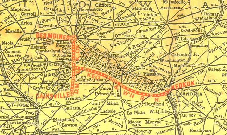
While studying the Burlington and Missouri River Railroad, my 1928 Railroad Atlas indicated that there was another CB&Q route about half way between the B&MR route and the Missouri border. This southern route consisted of the Keokuk and Western Railroad on the eastern end and the Humeston and Shenandoah Railroad on the western end.

1898
The Missouri part of the K&W was chartered in 1857 and the Iowa part was charted in
1866. The two were combined as the Missouri, Iowa, and Nebraska Railway in 1870. This line went bankrupt in 1885 and was reorganized as the K&W in 1886.

Jay Gould had built a branch of the Wabash from Bluffs, IL, to connect with Keokuk, IA. And he could use the K&W to get to Humeston, IA. So in 1881 he envisioned the H&S as part of a route that would allow him to connect at Omaha his Wabash RR with his Union Pacific RR. But as indicated in the B&MR posting, the CB&Q was concerned that Jay Gould was trying to box om the CB&Q and fought the construction of the H&S. Jay Gould and the CB&Q compromised by creating a company that was owned 50/50 by CB&Q and Wabash and the H&S was built as a joint initiative in 1881. (Wikipedia)

1882
So the 1882 map of the CB&Q system includes the H&S, but not the K&W. But the Wabash went bankrupt in 1889 and the CB&Q acquired control of both the K&W and H&S in 1901. So the 1928 Railroad Atlas shows CB&Q owning the entire route between Shnandoah and Keokuk, IA.

Because farmers wanted to be close to a town with rail service in the 1800s, this route that was parallel with the CB&Q mainline prospered until roads, cars and trucks made it redundant around 1920. My 1973 Railroad Atlas shows that only a few remnants of the original route existed except for the segment between Centerville, IA and Keokuk, IA, which was owned by the Burlington Northern. That final segment was abandoned in 1982.

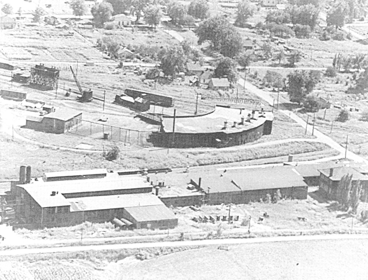
Photo from the "The K&W" page
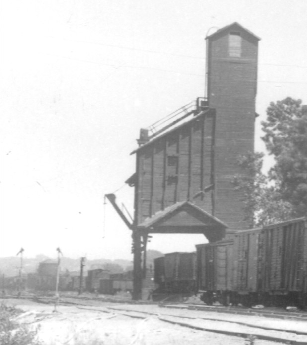
Centerville was the division point of the K&W and it had a roundhouse. The keokukandwesternrr.com is a great web site because it includes a lot of pictures of buildings. In addition to the roundhouse picture, "The K&W" page also has a coaling tower.
Photo from "The K&W" page

The text for the coaling tower is: "Fuel Station: Fairbanks-Morse 150 ton coaling tower located just north of National Carbide plant. Balanced bucket (elevator) style, 18'x28' wood frame, 10'x32' concrete machinery house, powered by F-M Type T 12hp gas engine, one coal pocket serving 2 tracks, 8'x8' tank compressor sanding facility serving 2 tracks. 36 ton per day average consumption per 1931 company records"


100 Truckloads a Day


Great Plains, select Shenandoah tab
The Jan. 18, 2015 issue of Evansville Courier & Press had a Business article on the impact of lower gas prices on the ethanol market by Josh Funk of the Associated Press. (After listing reasons why it could go up and reasons why it could go down, I guess the market is not supposed to change significantly.)


The newspaper had pictures of trucks unloading at the Great Plains Shenandoah, IA, plant. What caught my eye in the article was that they were unloading 100 trucks of corn a day. Is this because they have no rail service? Their web page indicates they have 12000+ feet of paired track.
Satellite
A satellite image indicates that one track is for unloading corn from covered hoppers and the other is for loading ethanol into tank cars. There were also a lot of tank cars parked on the railroad itself (below).

The railroad serving the plant is a remnant of the Burlington and Missouri River Railroad, and it is now owned by the BNSF. Even though it is owned by a Class I railroad, the branch is now more of an industrial spur because many tank cars were parked on the "mainline" in a satellite image. To show all of the cars, I have to use a low resolution so the tank cars are not much more than a "black line" in this image. Note the break in the line at the road so that the crossing is not blocked.

Satellite: tank cars parked on the "mainline"


Burlington and Missouri River Railroad

The source for this posting, unless indicated otherwise, is Wikipedia, Andreas' Nebraska
and Burlington Route Historical Society . But I ignored Wikipedia's dates because they did not seem to be correct.

While studying rail access to an ethanol plant in Shenandoah, IA, I came across the name Burlington and Missouri River Railroad because the town was platted by that railroad. The B&MR was incorporated in Burlington, IA, in 1852. With a branch founded in 1869 in Nebraska, it built toward Lincoln, which was recently designated the state capital. It entered Nebraska via Plattsmouth in 1870 and reached the capital that summer and reached the Union Pacific Railroad at Kearney on Sept. 3, 1872.  1872 is also when it was acquired by the Chicago, Burlington, and Quincy, which had completed a bridge over the Mississippi in 1868 to connect to it. A branch north to Council Bluffs was the third railroad to reach this railroad hub. The Chicago & Northwestern and the Chicago, Rock Island & Pacific were the first and second railroads to Council Bluffs. By 1882, the B&MR had completed a bridge over the Missouri River at Plattsmouth and built an extension to Denver, CO because Jay Gould bought the UP and some other railroads around it. The extension to Denver, CO, avoided being "boxed in" by Jay Gould's empire. The CB&Q had the first direct connection between Chicago and Denver and that extension gave it access to the Denver & Rio Grande and Western Pacific as a competitive route to the UP and SP. By 1882 the locomotives had switched from burning wood to coal and had become much larger. They could pull larger, more plush coaches and diner cars had been added to the consist.

1882
The 75-mile route to Ottumwa was surveyed in 1853, operations commenced on a few miles of track on Jan. 1, 1856. But the Panic of 1857 must have stopped construction for a while because it did not complete that route until 1859. Ottumwa was the western terminus for 6 years while the country fought a civil war. The maximum grade on the line was less than seventy feet per mile with 500 bridges, "from a single span over a miniature creek to a splendid structure half a mile long, like that over the Des Moines River." (Andreas')

1882
The slow construction across Iowa is a reminder that the B&MR had to live off the land because transcontinental bridge traffic would not materialize until 1869. It had a land grant from the Government of 2,383,208 acres, and it was able to prosper from shipping supplies to and crops from the farms along its line. And passenger traffic would be heavy in the horse-and-buggy days, including the many immigrants needed to help settle the land. There were also local resources to ship such as timber and coal. Later the railroad was also a trail head for thousands of Texas Longhorns (NEhistory).

The Shenandoah web page indicates that Burlington Northern Railroad operates the line and plans to have the line improved to Hazardous Material standards for 2006. This was probably so that it can ship ethanol from a local plant. Note that this web pages is obsolete because BN was merged into BNSF in 1992. But even though the branch is run like a shortline because tank cars are parked on the "mainline," a BNSF map does show it still owns the track through Essex and Shenandoah to Farragut.

Update: Later, CB&Q built a more direct route from Kansas City to Brookfield, KS and then abandoned most of the route west of Brookfield to St. Joseph.

Monday, January 19, 2015

Coal Mine Safety

Photo taken at The Museum of the Coal Industry
The geologic processes that made coal are similar to the processes that make methane gas. So one of the dangers of mining coal was releasing methane gas. To test the quality of the air, the miners would carry a canary in a cage with them.
Photo taken at The Museum of the Coal Industry
In 1815, Sir Humphry Davy invented a safety lamp. It had a fine mesh covering so the flame of the lamp would not ignite any gases in the mine. The photo to the right is a modern safety lamp. Normally, it would have horizontal lines painted on the transparent part. The height of the flame should be halfway up. If it was higher than that, it indicated there was gas in the air. If it was lower, it indicated that oxygen was below normal.

After visiting The Museum of the Coal Industry where the pictures of the cage and lamp were taken, I noticed an article in the Evansville paper with the headline "Sensors for Safety" on the front page. The picture below was also on the front page.
Photo by Timothy D. Easley with government and company escorts
Dylan Levan reported that the U.S. Mine Safety and Health Administration is requiring continuous mining machines to have proximity detectors because the most common cause of the 40 deaths at all the nation's mines last year involved hauling and mining machinery, including 10 at coal mines. Continuous mining machines have crushed 35 miners since 1984, and MSHA says most of those deaths could have been prevented with proximity detectors. But it has been hard to develop sensors that work in the harsh conditions of an underground mine. The mine operators played an active role in developing the sensors. About half of the 860 CMMs in the country now have them installed.

Note the bar near the top of the photo of this mine that is two miles underground. That is part of a roof support. After the CMM advances the working face, it is backed out and the wire mesh and roof supports are added. A roof support is added by drilling upwards so that a long rod can be inserted in the ground to hold the bar. The nut you see is fastening the long rod to the bar. Two decades  ago most deaths were caused by roof collapses, but those deaths have been reduced so that machines have now become the primary danger.

The article also had a side bar about underground mining. Notice that the walls, floor, and roof are grey, not black. They are sprayed with crushed rock to help mitigate fires. "Coal dust is highly combustible, and in the event of a blast, the rock dust mixes with the coal dust and prevents the spread of flames." In and out ventilation shafts are used to remove the methane gas and keep the air fresh.
Even for a short tour, media members were required to wear steel-toed boots, a hard hat with a light, safety glasses, reflective clothing and a heavy belt with a 10-minute oxygen canister. Before entering the mine, there was ashort training session with exygen breathers and an explanation of mines escape routes in case of an incident.
 

Sunday, January 18, 2015

More Plumes and Smokestacks

When I viewed the industries along the Sanitary and Ship Canal a few days ago, I did not notice any plumes. But on Jan 17, 2015, while driving south on I-355, I noticed that there were several plumes. My wife was able to get the camera out, learn how to use it, and get some pictures while we were still on the Veterans Memorial Bridge. And fortunately we were in the minivan so that we could better see over the bridge's side barrier.

20150116 0002
The engine head lights caught my eye. The picture of the engines is at camera resolution. One can verify it is BNSF/Santa Fe (i.e. orange) and determine that the train had five engines. I believe the plumes flatten out at a "ceiling," but it is hard to verify because the plumes are blowing towards the camera. In the next view, you can see the CN/GM&O/Alton tracks.

I need to do more research, but I suspect that some of these plumes are just water vapor out of cooling towers. Note that several of the stacks don't have visible output. Is that because the plants are "clean" or because they are idle? According to Google, the I&M canal is someplace among the trees in the below. I need to start exercising so that I can traverse the I&MC Trail Passage, which is probably on the towpath of the I&M canal.


On the same trip while traveling south on IL-130, I spotted plumes to the east. I believe this is the Gibson Generating Plant. On some monitors you can spot a blackish spot in the upper-left corner of this heavily cropped picture. Once the water vapor dissipates, there does seem to be some "smoke."

Then while driving south on University Parkway near Evansville, IN, I saw another plume. Note that there is two layers of sky, a blue layer over a yellowish layer. And the plume hits a ceiling at the boundary of the layers.


That generating plant has been on my "todo" list, and I have studied the map and knew about Green Valley Drive that parallels the railroad stub that supplies the coal trains. So I drove there to check out the plant. Fortunately, I stopped at the entrance to take a picture of the sign or I might have missed the PRIVATE ROAD WARNING. So we ended up taking some side roads. We got another "capped plume" shot. The plume is a little "dirty" after the white water vapor dissipates.

Fortunately, there was no traffic on the side roads so that I could stop and take pictures. This coal train was parked. I included the close up of the engines to show how much exhaust they were generating even though the train was not moving.


Unfortunately, the picture is not good enough to catch the logo or number. But it is not EVWR green. My dad said the plant receives coal from a mine that is south of Petersburg, IN. The Big Four owned the track that goes from Evansville to Petersburg, and it is now owned by Norfolk Southern. He mentioned that there used to be a parade of coal trucks up and down IN-62 and 57  until the railroad spur was built.

One reason I wanted to go down Green Valley Drive was to see what was on the west side of the railroad with their own unit-train loop of track. But a satellite image lets me identify the types of industry, if not the plant names.

The loop on the far west serves a coal transloading facility. So coal carried by the railroad can either be burned or loaded onto a barge.

After studying a known ethanol plant, the loop in the middle serves an ethanol plant. It has grain trucks unloading, grain bins on the right, fermentation tanks in the lower left, and both covered hopper cars (to unload corn) and many tank cars (to load ethanol) on the loop tracks.

Google
I'm learning that different levels of zooming in Bing uses different satellite images. By panning the zoom level of this image, I counted 16 trucks in various stages of unloading. But other zoom levels had no trucks.

Bing

Lemont: view from the parking garage

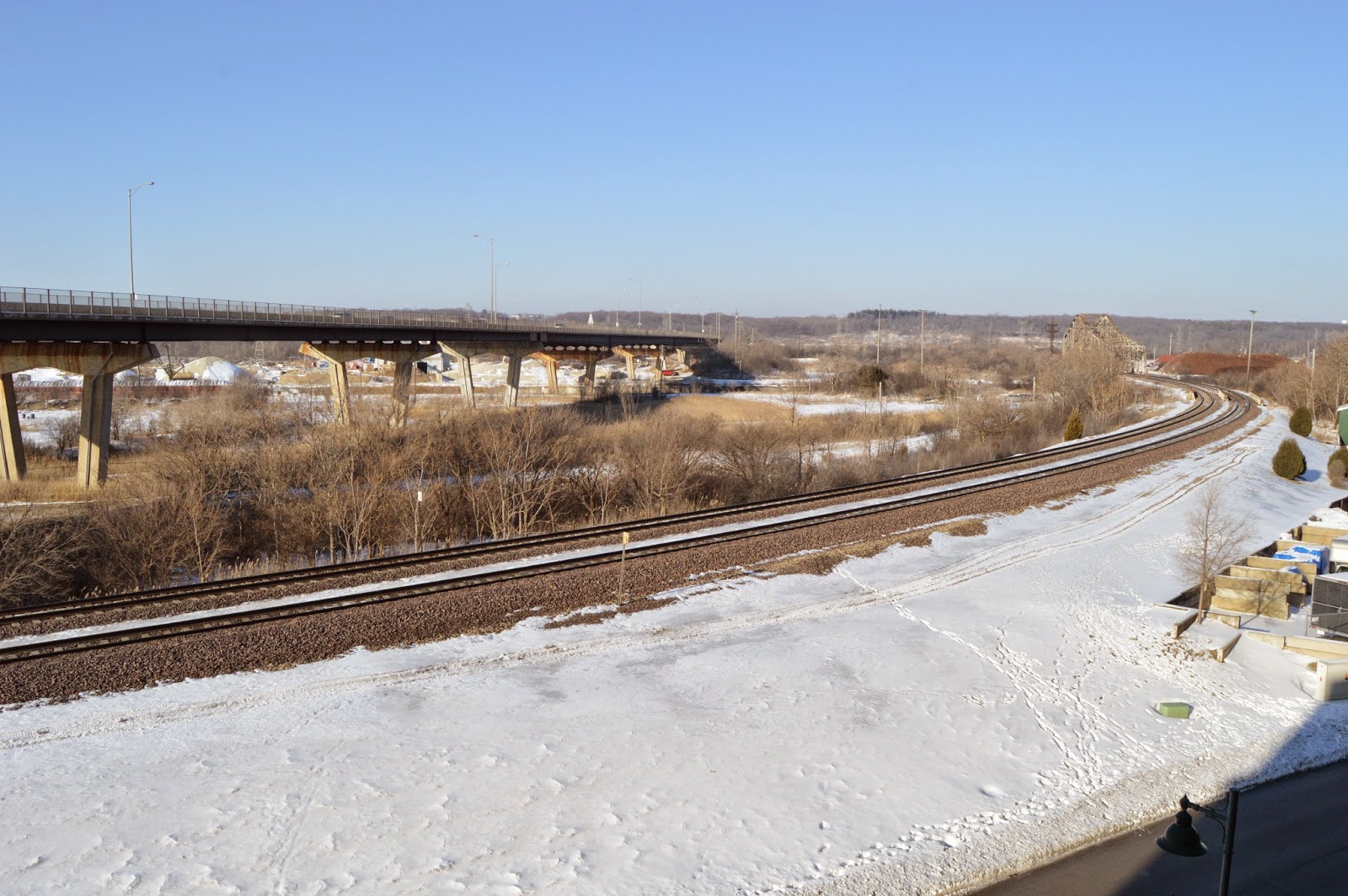
Since I was at the Keepataw Preserve, I checked out the view of the Santa Fe and Sanitary and Ship Canal from the Lemont Parking Garage. I went to the third level of the garage because it was the top floor that was still covered. And it was plenty high. The view of westbound trains is great. But the view of eastbound trains is not as good. After the weather warms up, I need to check the top floor. It should have a good view of eastbound, as well as westbound, trains. Scenes of someone checking the track gauge  has some more views of the Santa Fe tracks.

On the way into Lemont, I noticed that there was no ice on the canal and there were a lot of barges parked along the side. In fact I saw more action than I have ever seen in the summer. Specifically, higher piles and yellow equipment crawling on them in both the material and landscaping companies. Because of the brush along the canal, it was hard to see activity on the canal. I waited until the towboats were in a clearing before taking a picture.

In the picture below is a towboat on the right and one near the middle pushing a, probably empty, barge downstream. To the right is a closeup of the towboat with a barge. It is interesting that the captain is leaving the pilot house down even though it  has passed under the Santa Fe bridge.

And then the parked towboat headed upstream. Mary C has also been reported in May 23, 2014, May 24, 2014, and July 19, 2014.

While I had the telephoto lens on the camera taking pictures of MoW activity, I almost missed another empty barge heading downstream. In this case the pilot house was raised so that it can see over an empty barge. The closeup at the right is at camera resolution. Even with the pilot house raised up, there is a big blind spot in front of the tow.

And then there was another downstream barge being hip-towed.