Friday, January 26, 2024

1906 Wachusett Dam on Nashua River and Aban B&M Trestle and Tunnel in Clinton, MA

Dam: (Satellite, 1,198 photos)
Tunnel, West Portal: (Satellite, 649 photos)

The dam was built in 1906 as part of a water supply. Dogs are not allowed in the parks because the 65 billion gallon reservoir is a water supply. The reservoir "covers 108 square miles with 37 miles of shoreline." [mass]
"At the time of construction, the Wachusett Reservoir was the largest in the world. It remains a great engineering feat and is one of the few unfiltered water supplies in the country. " [Mass_reservoir]

Brian Hale, Aug 2013

Peter Brinley posted
No longer in service, Hydroelectric Turbines at Wachusett Dam in Massachusetts.

 Mass_dam
"The Wachusett Dam maintains the honor of being the largest hand built gravity dam in the world. Constructed of granite masonry, the dam stretches 944’ [288m] across." The height of the dam is 115' (35m) above ground and 112' (34m) below. It tapers from 22.5' (6.9m) at the top to 185' (56m) at the bottom. The spillway is  452' (138m) long.

I found the spillway on the north side after I saw some photos of it.
Clay Mangiameli, Oct 2023

Did the power plant quit running when they turned the tailrace into a fountain?
Anthony Trinciante, Sep 2022

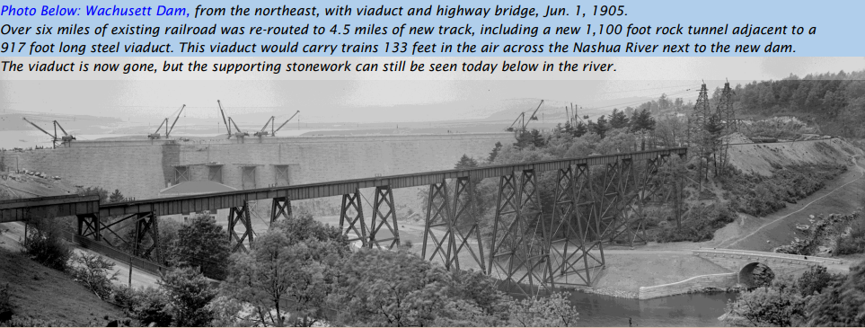
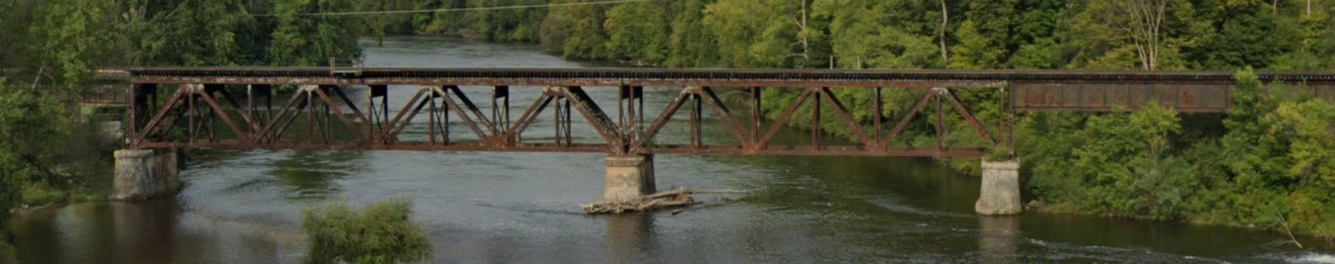
Actually, there was no outlet at the base of the dam because the spillway is on the side and the normal flow is diverted into an aqueduct as a water supply. This map also shows were the trestle crossed the river when the Boston & Maine tracks were rerouted around the dam site.
1952 Clinton Quad @ 24,000

The top middle diagram shows that there is more of the dam underground than above.
DigitalCommonwealth

In 1907, because of a landslide, they had to build a 2-mile (3.2km) long dike.
Satellite

Mass_dike


CB&Q Covered Bridge over Vermilion River at Streator, IL

(Bridge Hunter broke Apr 22, 2023; Satellite)

John Burt posted
CB&Q covered trestle over the Vermilion River at Streator on the Zearing branch. 1927. The cover was removed in the early 30s.
Thomas Whitt shared
Wow!

John Burt commented on his post
This is all that's left of the trestle today.

Dennis DeBruler commented on John's post
 https://www.google.com/maps/@41.1318262,-88.8516792,90m/data=!3m1!1e3?entry=ttu


Thursday, January 25, 2024

1988 Great Seto Bridges in Japan

(Satellite, 2,267 photos)

"Construction on the double-decker bridge began in the late 1970s, and took 10 years to complete. At a cost of $7 billion dollars and the lives of 13 bridge construction workers, the bridge was opened in 1988." [JapanTravel]

From south (Shikoku Island) to north (Mainland (Honshu Island)):
Street View, Nov 2020

Street View, Apr 2015

Street View, Apr 2015

CoolJapan, 1 of 5 photos
Great Seto Bridge (Seto Ohashi) is the inclusive name for six consecutive bridges connecting five islands in the Seto Inland Sea.

wattention, 1 of several photos
"world’s longest two-tier bridge"
The bridges have a total length of 13km (8 miles).
 
Highway Engineering Discoveries posted
The Great Seto Bridge is a series of double deck bridges connecting Okayama and Kagawa prefectures in Japan

The six bridges from south to north [wikiwand]:
  • Minami Bisan-Seto Bridge is "a double-decked suspension bridge with a center span of 1,100 meters (3,609 ft) and a total length of 1,648 m (5,407 ft)." The roadway is 93m (305') high and makes the HighestBridges list.
  • Kita Bisan-Seto Bridge is another suspension bridge that shares an anchorage with the above bridge. "The center span is 990 meters (3,248 ft) and the total length is 1,538 m (5,046 ft)."
  • Yoshima Bridge is "a continuous double-decked truss bridge with a main span of 246 meters (807 ft) and a total of five spans with a length of 847 meters (2,779 ft)." It keeps the road and railroad elevated over the Yoshima Island.
  • Iwakurojima Bridge "is a double-decked cable-stayed bridge with a center span of 420 meters (1,380 ft) and a total length of 790 meters (2,590 ft)."
  • Hitsuishijima Bridge "is a double-decked cable-stayed bridge with a center span of 420 meters (1,380 ft) and a total length of 790 meters (2,590 ft)."
  • Shimotsui-Seto Bridge "is a double-decked suspension bridge with a center span of 940 meters (3,080 ft) and a total length of 1,400 meters (4,600 ft)."
 
Bridges Now and Then posted
Construction of the Great Seto Bridge, Okayama and Kagawa Prefectures, Japan, September 7, 1986. (Leo-setä)


Wednesday, January 24, 2024

Marquette Rail/CSX/PM Bridge over Muskegon River in Newaygo, MI

(Bridge Hunter broke Mar 22, 2023; Satellite)

Street View, Aug 2021

Clare Union Railroad Depot posted
PMRR files, Part 3: C&O Historical Society calendar

The view from a river access:
Michael Sluis, Oct 2020

Brian Caswell Train Photography posted
Four leaders for Marquette Rail , across the Muskegon River in Newaygo Michigan - Northbound to Baldwin from Sparta / October 2023
Tim Shanahan shared

The grain elevator in the background of Brian's photo is obviously rail served because some hopper cars have been delivered.
Satellite


Main Street and CO&P Bridges over Fox River in Ottawa, IL

(Bridge Hunter broke Mar 22, 2023; Satellite)

CO&P = Chicago, Ottawa & Peoria Interurban

I looked closer at the photo to try to determine if it was pin connected. That is when I noticed there are two bridges. One with three truss spans, and a second with one tied-arch span. I presume the truss bridge was for street cars. A tied-arch span would have been way ahead of its time back then.
David Johnson posted
Ottawa ,Ill main street bridge

Street View, Oct 2019

The Main Street Bridge also carried the Chicago, Ottawa & Peoria interurban across the Fox River.
1915/15 Ottawa Quad @ 62,500

This is a reminder that interurban railroads typically use streetcar tracks to service towns along the way. The dashes in the streets indicates street running. I zoomed in because I noticed the CO&P leaves town on the west side one block further north than it enters on the east side. We see that it went north just west of the Main Street Bridge.
Digitally Zoomed

The UCEB (Ugly Concrete Eyesore Bridge) was built before 1939.
1939 Aerial Photo from ILHAP

Tuesday, January 23, 2024

CNJ Bridge/Former Trestle over Road and River in High Bridge, NJ

(Satellite, a trestle still stands under the tree-lined embankment.)

CNJ = Central RR of New Jersey 

It appears to be tunnels through a hill. But it is more like culverts through an embankment. Because of the trees, I can't capture the true size of the embankment.
Street View, Nov 2021

We get a better hint of the embankment on the east side.
Street View, Nov 2021

Metrotrails posted two photos with the comment:
Metrotrails Then and Now Series: Historic postcard image of the double culvert carrying Arch Street and the South Branch of the Raritan River beneath the former Central Railroad of New Jersey in High Bridge, New Jersey, compared to the same scene on our 2022 visit.
The Jersey Central built to the town in the 1850s, and the settlement took on the name of the giant trestle that once spanned the site. 
The wooden trestle was rickety and the piers were said to be too far apart, causing the spans to sag when heavy trains passed over. The trestle was then back filled and a culvert placed for the road and river.
Many believe the town was named for a much smaller trestle that served Taylor Wharton, removed in the 1990s, and many have no idea a large trestle is buried in the enormous earthen fill on the south side of town.
Metrotrails shared
1

2

Dennis DeBruler commented on the share
The contour lines on a topo map make it easy to see the valley the embankment crosses.
1954 High Bridge Quad @ 24,000


Monday, January 22, 2024

2022 12-Lane Infinity Bridge in Dubai, UAB

(Satellite, 481 photos)

This is another international example that cable-stayed bridges don't need to be just some boring towers.

NewCivilEngineer, 1 of 4 photos

ColorKinetics, 1 of 5 photos
"The aptly named Infinity Bridge is an engineering masterpiece. It features a 42 m (138 ft) high steel arch representing the mathematical symbol of infinity to convey Dubai’s limitless and infinite goals. Spanning 295 m (968 ft) and 15.5 m (51 ft) above Dubai Creek, the bridge accommodates 12 lanes of traffic as well as pedestrian crossing"

Even the street lights have some pizazz.
Street View, Feb 2022

I thought the arches and cables were supposed to hold up the deck. But they built the deck first, and then used the deck to hold up five temporary towers to hold the arches while they were being built. [maegspa]
Mammoet
The 40 steel segments weighed up to 130 tons.
Mammoet used a Demag CC 8800-1 while Aertssen Machinery Services (AMS) used a Demag CC 3800.

It looks even more like the infinity symbol from above.
Satellite

aaconsultancy
"The Infinity Bridge has six lanes in each direction and is capable of accommodating 24,000 vehicles per hour. It also features a pedestrian and cycling track."
[When I first saw the number 24,000 in other sources, that number struck me as low, even for a 4-lane bridge. But then I noticed the "per hour" unit. If I convert to "per day" by multiplying by 24, I get 576,000. But when I proofread this, it occurred to me that 24 is too high because not all of the hours of the day would be busy. If I use 8 hours, I get 192,000.]

Nilesh Trivedi posted
The Infinity Bridge 
Dubai, UAE

This photo shows that the deck can support itself without the arches. But I assume the arches and cables are needed to help support the live load.
tonygee