 |
| Satellite: loop of track in upper-left corner |
While studying the route of the
Paducah & Louisville Railway (PAL), I noticed a loop of track on the map east of Madisonville, KY. Those loops are used to load unit trains. Zooming out in the satellite image, one sees the tell-tail land scars of strip mining for coal. But these are "old" scars --- they are covered with trees.
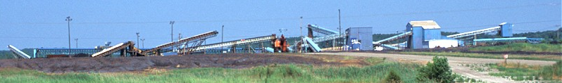
But looking south of the loop, I see active coal stockpiles. So it looks like trains are still being loaded. Then I noticed the conveyor belt that goes towards the northeast and that is highlighted by the yellow lines.
The conveyors are going to the mine heads of underground mines. The
Alliance Resource Partners have 3 underground mines along the PAL --- Dotiki, Hopkins County Coal, and
Warrior Coal. They all use "continuous mining units employing room-and-pillar mining techniques" to produce high-sulfer coal. According to the
P&L System Map with "Coal Facilities" selected, the loadout in the satellite images above is the Cimarron Mine. Dave noted in 2004 that the Cimarron Mine was idle. I assume the loadout facilities
have been "recycled" to serve the newer underground mines.
The Warrior Mine has its own loadout. The P&L Map also shows the
McHenry Mine. But I think the name is obsolete. The web page indicates that its last year of production was 1995. The Armstrong Coal Company referenced on the P&L Map has/is developing
several mines in the Ohio County --- both surface and underground. They have a 150-car rail loop for automated loading of rail cars at their
Midway Mine that connects to both the P&L and CSX, but I could not find it on the map.
There are several other mines listed on the Alliance Resource Partners
page. The River View mine is particularly noteworthy because of its high
output, 9.3 million tons in 2013, and because it loads directly
into barges on the Ohio River at Mile Post 843. The satellite image is
the storage and load facilities. If you follow the conveyor belt, the
mine head is east and a little south of this area.
I was aware that there is a lot of coal in Illinois and southwestern Indiana because of the Illinois Basin geologic formation, now I have learned that this basin extends into western Kentucky.
The WSJ article was interesting because it says the primary market for Illinois Basin coal is southeastern utilities that are switching from Appalachian Basin coal. Because the seams are thicker and use non-union labor, the production costs are half the costs of Appalachian coal. That savings more than offsets the longer train routes after sulfur dioxide scrubbers have been added to the power plants. This contradicts what I had read and stated in a
previous post that Illinois coal was being shipped to China. So that goes on the "head scratching" pile.
If you look at
Google's road map, you can see the land is "pock marked" with bodies of water. This indicates the land has been strip mined. Panning the map reveals a line of pock marked land runs along a line from Providence, KY, through Madisonville and Central City to Morgantown.
Update:
.jpg) |
Wendell Bennett posted
Colonial Mine 2550 Madisonville Ky |
%20HISTORICAL%20STRIPPING%20SHOVEL%20&%20DRAGLINE%20ARCHIVE%20_%20Colonial%20Mine%202550%20Madison.png) |
| Comments on Wendell's post |
The
Kentucky Interactive Coal Mine Maps didn't know about Colonial Coal.
The only strip mine I could find around Madisonville doesn't look active and doesn't have a dragline.
 |
| Satellite |


.jpg)
%20HISTORICAL%20STRIPPING%20SHOVEL%20&%20DRAGLINE%20ARCHIVE%20_%20Colonial%20Mine%202550%20Madison.png)

No comments:
Post a Comment