Post Civil War: South Water Street Market
 |
| Jeff Davies posted
South Water Street Market. Chicago. 1926.
Photo courtesy of Bruce Kelleher.
|
 |
| Chicago History Museum from WTTW |
 |
| Leon Paa Rios posted Chicago water market.... Found this framed at my job |
 |
| Richard Pitchford posted Water Street Market ran parallel to the river, with buildings that backed up onto the water. Notice the booking office for the South Haven Line – the company that owned the ill-fated steamship Eastland. Original Chicago posted Water Street Market ran parallel to the river, with buildings that backed up onto the water. Notice the booking office for the South Haven Line – the company that owned the ill-fated steamship Eastland. The elevated line is the Lake Street Elevated Railroad (later part of the Green Line). It crossed South Water Street (now Wacker Drive) via a terminal stub on Market Street near Madison Street. This structure operated from 1893 until its demolition in 1948. It served as the original eastern terminal before the Loop was completed. Paul Webb shared |
 |
| Patrick Stevens posted |
 |
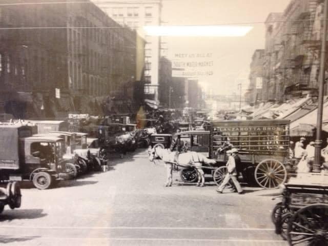
| George Coy posted Came across some old pics of Chicago in the Library of Congress, I thought your group might enjoy them This one is dated April 1915. Hope this is okay with your group This is the description: Looking west on South Water Street, Chicago, crowded with horse-drawn wagons and motor trucks filled with produce for market, Apr. 1915 |
 |
| Dragi S. Trajkovski posted POSTCARD CHICAGO - SOUTH WATER STREET ,looking WEST from STATE STREET -1905 |
 |
| Dominic Rossi posted South water market 1941? [Some comments indicated it would be this market.] |
 |
| Xavier Quintana posted From Vintage Tribune: South Water Street Market, circa September 1925. (Vintage Tribune) Xavier Quintana also posted David Utech: Wacker Drive under construction at the top of the picture. |
GettyImages
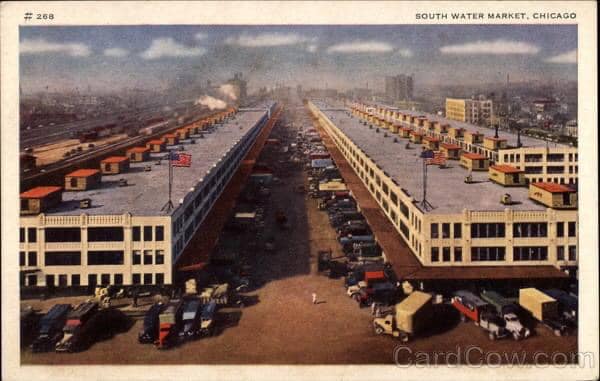
To quote Northwestern's caption of this picture: "When South Water Street was made over into Wacker Drive there was a wholesale exodus of the scores of commission houses. This shows the new home of the South Water Market between Fourteenth Place and Fifteenth
Street from Morgan Street to Racine Avenue." This 1929 photo would be looking West. Of note is that there are still a lot more horse and wagons then trucks. When I see pictures like this, I have to wonder what do they do with all of the "road apples?"
Update: Northwestern seems to have allowed their security certificate to expire. But I came across another copy of the picture on Facebook. Patrick's comment indicating 1956 is a good example of not being able to believe everything you read on the web. There were not that many horse and wagons in 1956!
I could not find rail access in a 1938 aerial photo. Later I found confirmation that it did not have rail car access. (Update: CN&W's 1947 video indicates their Morgan Street Yard was close and dedicated to perishable freight. The video shows blowing snow ice into a car to keep it cold during warm weather and warm during really cold weather. When the merchants were forced to move to South Water Market, the IC and Santa Fe built the Chicago Produce Terminal for them and other railroads to use. The trucks had to travel less than two miles to get to the merchant market.)
1920's: South Water Market
 |
| Northwestern University |
 |
| Patrick Stevens posted SOUTH WATER MARKET 1956 |
 |
| ILHAP |
 |
| Dominic Rossi posted Original south water market Dominic Rossi: I worked there 88- till they closed in April 1993, my father was there for 23 years |
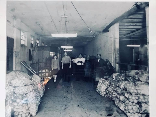 |
| George Dana commented on Dominic's post My grandfather owned Jiffy Spuds and then City Wide Produce. This photo might have been before south water market. He’s in the middle with the white shirt. |
 |
| Jeff Nichols posted South Water Street Market, 1955. University of Chicago Library, Special Collections Research Center, apf2-09929 Paul Jervert shared |
When I studied the aerial photo of the 16th Street Corridor for the St. Charles Air Line Railroad posting, I wondered what the long, horizontal buildings in the middle of the photo were used for. Now I know --- South Water Street Market.
 |
| ILHAP |
 |
| Satellite |
Fulton Street Market
 |
| Patrick Stevens posted FULTON STREET MARKET - FULTON & GREEN LOOKING WEST |
21st Century
 |
| Satellite |
 |
| Satellite |
I checked with a 1938 aerial map to confirm that they filled in a couple of slips originally created in the 1800s by the South Branch Dock Company to create land for this new market building. Even though it is built in the 75-acre industrial park that CB&Q created with the dock company when it built its access into Chicago in 1862-4, the market building does not have rail access.
The hours are from 3:30-4:00am to noon. "CIPM merchants offer the widest possible selection of fresh fruits and vegetables, nuts, dried fruits, herbs, spices, and specialty dry goods." (Agrilicious) The warehouse contains "ripening rooms" that control temperature, humidity, gassing, and ventilation, which controls ripening rates. Estimates are that produce in Chicago is a billion dollar business. This terminal supports not just the Chicago land area, but a tri-state area. (WBEZ) And they are trying to expand their reach to Iowa, Michigan, Ohio, and additional Midwestern states. There are other competitors such as Central Grocers in Joliet.(ThePacker)
 |
| FourSquare |
If you skip to 1:00 in the video you can see about 20 seconds of loading doc activity. Timestamp 6:04 was also interesting because it shows an order picker filling an order from a selection of 300 products and a view of the size of the cooled warehouse rooms. Note that the video was made in 2009, so the market was viable even during the recession.
Updates
 |
| Glen Miller posted [I have heard of this, but I don't know where it is. I don't have time to research it now.] |
Thanks for your great information, the contents are quite interesting. Chicago Third Party Logistic Warehouse
ReplyDeleteMaxwell st was the old "jewtown" along S. Halsted from the underpass at about 14th St. northward to just soth of Roosevelt. By the '80s it was a slum area. Most buildings were gone west of Halsted in that stretch and the vacant lots teemed with an informal "de facto" flea market that was a vestage of the jewtown era. Burning barrels for heat and garbage everywhere. Daley Jr. threw them all out and sold block after block to UIC to expand. Market was banished to I think Canal St and "officialised" There was a hue and cry about the closing of the Maxwel slum but they never stood a chance. DALEY NEVER LISTENED TO THE COMMON MAN, Despite what you may have been told! The3 picture immediately above is Halsted probably facing north during the market on the weekend in the '30s probably.
ReplyDeleteI agree that no aerial photos show South Water Street Market with rail service. However, the Chicago Switching District Tariff 22-C Directory of Industries from both 1956 and 1967 list the South Water Market Terminal Company at 15th & Morgan Streets, served by the B&OCT (on behalf of B&O, CGW, and Soo). The listed industry is "Perishable products."
ReplyDeleteCould this have been part of Griswold & Bateman? Alternatively, there was another large, rail-served warehouse on the southwest corner of 14th Place & Sangamon. What was this place?
This article also suggests that South Water Street Market was basically exclusive to produce. Was there a Chicago equivalent for meats, dairy, and fish? And how would railroads have interacted with it/them?
From a nuts-and-bolts railroad operation viewpoint, I'm also curious how other railroads, including the smaller ones with less perishable freight due to smaller service area, arranged regular daily service into CNW's and IC/ATSF's produce yards. For example, C&EI, Monon, Soo Line, or GTW, were fully capable of bringing in perishable freight into Chicago on any given train. But it would be in smaller numbers, perhaps only two or three cars per day at times. Were they interchanging this traffic with CNW, IC, or ATSF at outer-Chicago interchange points? Or did every single railroad make a call into one of these two produce terminals regardless of volume? Seems like this would have caused quite a bit of congestion. I can't imagine they were sending all their perishable freight to BRC, IHB, or B&OCT for delivery into CNW's Potato Yard or the CPT. That would just take too long.
The Monon would run trains to the Produce Terminal, at least occasionally. Other roads used to run transfers there as well. I've seen photos of Erie, N&W and other roads power at the Potato Yard. There are records among the Monon Historical Society that show management's concern about the fact that, not only were there runs of single reefers sometimes, but also that crews couldn't get back to South Hammond without heavy overtime. They sure had to get through a lot of junctions, and many were manually controlled!
Delete