NorthAmericanInterlockings: Wilhelm Garon
no Chicago and Northern Indiana Railroad Interlocking Towers
The 1952 historic aerial is best because new ballast had been spread on the B&OCT track and it shows up as a white line.
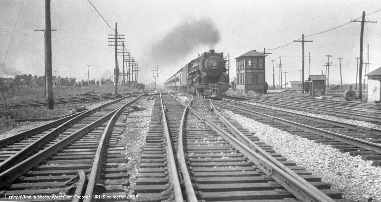
The two lines above the "A" of Athletic Field was the NYC railroad. Today they are owned by NS. MS Tower not only controlled the crossing and connection with NYC, it controlled the crossing and connection with the original B&O main into Chicago (next tracks north) and the connection with the EJ&E (northernmost tracks). [Trainorders, railroad.net]
 |
| 1980 Whiting Quadrangle @ 1:24,000 [The 1953, 1960 and 1968 maps are similar. None of them show the towers nor the connections from B&OCT to NYC and to B&O.] |
 |
| One of seven images posted by Jon Roma |
"This was just a lucky grab shot. It is the only time I ever saw any activity on the B&OCT Whiting Branch north of the refinery. You are correct that most of the traffic on the Lake Sub headed for East Chicago, actually Pine Jct. on the far west side of Gary."
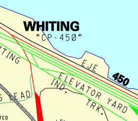
Evidently the tower had been removed by 1982 because according to Haynes' track diagram and Wilhelm's photo (see links at the top), it should have appeared in the right side of this photo. Also, a sign on the signalling equipment cabinet indicates CP450, which also implies the tower is gone. I've learned that when a junction was converted from local tower control to remote CTC control, it was given a Control Point number based on the nearest mile marker. CP450 was the original number based on millage from Pittsburgh. By 1982 the conversion to use miles from Buffalo had happened and this was really CP505.
In fact, the tower was closed in Oct 1969 and torn down in Aug 1972. [Trainorders]
1980 Jeff Stack Flickr
p 156 of The Lake Shore & Michigan Southern Railway by Dave McLellan and Bill Warrick has a 1906 photo of the tower looking east with the B&OCT tracks crossing five NYC tracks. The tower was electrified in 1905 replacing a manual plant. The EJ&E tracks were the Lake Shore & Eastern back then.
The fact that the original Whiting Tower (B&OCT vs. Pennsy) is gone because the Pennsy route was abandoned and CP505/CP450/MS controlled the crossing and connections with NYC, B&O and EJ&E explains why this map labels the junction of the B&OCT with three railroads as simply WHITING. I presume the other reason this is treated as a single junction is that the B&OCT must arrange to cross all of the affected railroads before it takes a train through this junction. Today, the B&OCT track is abandoned starting just south of of 119th Street. So this junction no longer exists.
 |
| B&OCT Map |
This and all your recent posts regarding NYC/PRR and Chicago are excellent resources. I appreciate how you have brought them all together so it makes sense. I grew up in Cleveland and have always wondered how it all worked past Toledo. Thanks!
ReplyDeleteI especially enjoy your commentary and summary of information on railroads around the Calumet Region. I would like to add some additional info on MS/CP450/Whiting. Both a 1976 Chessie System and a 1967 B&O employee timetable refer to the junction as Whiting, with no distinction between the ex-PRR and ex-NYC line crossings. This historical reference probably explains why the CSX map still labels it Whiting (and the CP450 should be CP505 by 1999). Also, I recall B&OCT locals waiting at the home signal south of CP450/505, having already passed Whiting Tower, so sometimes the lineup though the junction was not guaranteed.
ReplyDeleteThe CSX map is essentially a variant of the Chicago Terminal District maps, a great resource for the history of railroads in Chicago. There is a digital copy of the 1951 map online at the Barriger Library at the U. of Missouri–St. Louis. One odd thing about the 1999 CSX map is that many long-abandoned tracks are still shown, yet some current tracks, including even B&OCT tracks, are omitted.
Ok ple are going to call bulls. On this but i worked the last shift at Ms b4 it was shut down . I stAred at a ctc box for 8 hours. I was home on leave from the air force. And the chief dispatcher called asking if i was home! This was just b4 the
ReplyDeleteCutover to the former PRR LINE SUPERCEDED the NYC main which was then officially abandoned at 2300 that nite. I took the last msg from the dispatcher. MS had been my first home tower and was officially my last. I went back to Grand Forks 2 days later very sad