The next dam upstream is Wilson Dam.

An overview of the upstream side, which of course is boring.

These people are fishing by the powerhouse when there was very little flow through the dam.
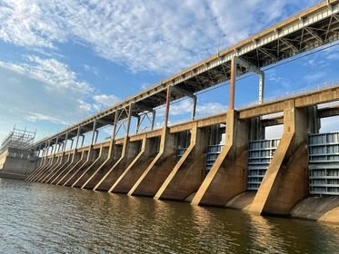
TVA posted four photos with the comment: "Pickwick Landing Dam is one of nine Tennessee River dams providing a 652-mile navigable waterway from Paducah, KY, to Knoxville. Construction started in 1934 and began generating electricity on June 29, 1938. 84 years later, Pickwick Landing continues to generate clean, reliable, low-cost energy!"
Pickwick Lock posted two photos with the comment: "Here are a couple photos from one of our pleasure craft passing through Pickwick Lock, upbound. Thanks for the photos. 📸 Paul Uhl"
1

Some photos my wife took as we drove across the dam from the south side to the north side. I asked her to take quite a few because it was obvious that they were doing some sort of construction.


 You can tilt your head easier than I can rotate the photos. :-) She was leaning over and shooting these shots through the front windshield since the locks were on the downstream side as we headed North.


We then drove south across the dam because, with my wife closer to the downstream side, I was hoping she could get better shots of the power plant and spillway water turbulence. It looks like at least some of the turbines were running. The camera did a good job of not focusing on the chain-link fence.


The road down to the river on the downstream river bank was closed on the south side as well. There was water along side AL-128 between the dam and the interchange with AL-57 where I turned around and headed north again.


And then we got more photos of the construction equipment as we headed north again across the dam.


This has a good demonstration of a hydraulic jump. (The "hump" of water where the fast-flowing water meets the slower-flowing water.)
Pickwick Lock posted two photos with the comment: "M/V Rocketship locking upbound yesterday evening."
Pickwick Lock posted five photos with the comment: "These photos were sent to us by the Pleasure Craft that locked through yesterday afternoon. Thank You for the photos. 📸 Pam Page Wolfe"
Dec 21, 2022:
Pickwick Lock posted two photos with the comment: "Here are a couple photos taken from across the lake of the M/V Sheryl B Reeves as they are breaking the boat out from the tow and heading over to the Auxiliary Lock to lock lightboat downbound. Then go pull their barges from the Main Lock and complete the fast double lockage. 📸Phil Hollinsworth. Thank You for the photos."
 |
TVA
|
 |
| Pickwick Lock posted [The text is not of general interest, but the photo is.] |
When we arrived at this dam, the road down to the boat ramp on the north side was closed. I assume it was because it was under water. We could go only to the upstream side. They did have a turbine display on that side.
 |
| 20200219 1335 |

An overview of the upstream side, which of course is boring.

These people are fishing by the powerhouse when there was very little flow through the dam.
 |
| Screenshot |
In this satellite image with a moderate river flow, that fishing platform seems to be under water.
 |
| Satellite |

The above flows are over 2,000,000 gps. Because that road was closed, I couldn't even get a glimpse of the downstream side. So I'm going to have to rely on others. Fortunately, other people are also intrigued by spillways in action.
(new window)
Last year it was almost 400,000 cfs and all of the roads down by the river were under water. The campsite was also under water.
(new window)
Looking at the lock walls, there is not much drop between the upper and lower pools.
(new window)
Last year it was almost 400,000 cfs and all of the roads down by the river were under water. The campsite was also under water.
(new window)
Looking at the lock walls, there is not much drop between the upper and lower pools.
 |
| Screenshot |
 |
| Pickwick Lock posted Looking up toward the Spillway area from the river below. 📸 Colby Hutton Patrick Moore: Family day |
(new window) This year's [2020] flood. This was taken four days before we were there. And it had been raining during at least some of those days.
While checking out the YouTube videos, I found an explanation of the construction activity that we saw when we took the road across the dam.
(new window) They are still fixing the campgrounds from last years flood.
Pickwick Lock shared some TVA photos with the comment: "National Hydropower Day is coming up on August 24 [2021] and we are no strangers to hydropower! Through our 29 power-producing dams, we have been providing clean, renewable, and low-cost energy since 1936. #TBT
For more historical info on our dams 


TVA posted four photos with the comment: "Pickwick Landing Dam is one of nine Tennessee River dams providing a 652-mile navigable waterway from Paducah, KY, to Knoxville. Construction started in 1934 and began generating electricity on June 29, 1938. 84 years later, Pickwick Landing continues to generate clean, reliable, low-cost energy!"
 |
| 1 |
 |
| 2 |
 |
| 3 |
 |
| 4 |
 |
| Dennis Sayles posted Pickwick Dam control room at Pickwick Powerhouse, Hardin County, Tennessee. The equipment for the first two units is in place. All lighting is indirect to avoid reflections on instrument faces. Recessed lights along the rear wall illuminate the back of the main panel. The ceiling is acoustic tile, and the floor is linoleum. A series of glass panels, in back of the operator seated at the desk, permits a view of the generator hall. By means of a balcony visitors can inspect the control room through these panels. Taken between 1933 and 1945. |
 |
| Pickwick Lock posted M/V Randy Bagents waiting lock turn. This view is from the wheel house of the towboat, below the lower gates, looking upbound. |
 |
| Pickwick Lock posted Wheel House view from the M/V Capt. Kenny Cady as they shove through the lower gates of the Main Lock Chamber, headed upbound. Thank You Henry for the photo. 📸 Henry M Jones |
Pickwick Lock posted two photos with the comment: "Here are a couple photos from one of our pleasure craft passing through Pickwick Lock, upbound. Thanks for the photos. 📸 Paul Uhl"
Paul Uhl: I’m always amazed by the size of these gates and the engineering behind it - a 52’ drop - see ya in the spring, thanks guys!!!
 |
| 1 |
 |
| 2 |
Dennis Sayles posted two photos with the comment: "TOP: Original Tennessee Valley Authority, 1944. The Pickwick Dam control room at Pickwick Powerhouse with the equipment for the first two units in place. All principal lighting is indirect to avoid reflections on instrument faces. Recessed lights along rear wall illuminate the back of main panel. Ceiling is acoustic tile, and the floor, linoleum. Series of glass panels in back of the operator seated at desk permits view of generator hall. By means of a balcony visitors can inspect the control room through these panels. BOTTOM: Pickwick Dam, Tennessee.
Brett Wanamaker shared
 |
| 1 |
 |
| 2 |
The industrial buildings in the background would be the PCA paper mill. I'm glad to see emissions coming out of the smokestacks because I assume that means it is operating. On our trip across northern Alabama we passed a huge paper mill that was closed and had its sign covered over.

Some photos my wife took as we drove across the dam from the south side to the north side. I asked her to take quite a few because it was obvious that they were doing some sort of construction.


We then drove south across the dam because, with my wife closer to the downstream side, I was hoping she could get better shots of the power plant and spillway water turbulence. It looks like at least some of the turbines were running. The camera did a good job of not focusing on the chain-link fence.


The road down to the river on the downstream river bank was closed on the south side as well. There was water along side AL-128 between the dam and the interchange with AL-57 where I turned around and headed north again.


And then we got more photos of the construction equipment as we headed north again across the dam.


Note the two workers on top of the left barge.
 |
| Screenshot The M/V Debbie Graham arriving on the lower long wall this afternoon with 10 barges. Pickwick was discharging 204,000 cubic feet of water per second from the spillways. Video: R. Boyd |
This has a good demonstration of a hydraulic jump. (The "hump" of water where the fast-flowing water meets the slower-flowing water.)
 |
| Screenshot @ 0:11 This is what 204,000 cubic feet of water per second looks like on the downstream side of Pickwick Dam. STAY AWAY!!!!! Video: R. Boyd |
Pickwick Lock posted four photos with the comment: "The M/V Magnolia visited us this morning and was carrying more infrastructure components down the Tennessee River and then up the Ohio River to Brandenburg, KY. Brandenburg is at Mile 646 on the Ohio River."
Jeff Ratledge shared
It is serendipity that Jeff shared the above post when he did because it let me catch a photo of a high flow through the spillway.
 |
| 1 |
 |
| 2 |
 |
| 3 |
 |
| 4 Pickwick Lock: These tows come through Pickwick quite often. This one started its journey in Louisiana, traveled up from the Gulf Coast from Mobile, AL, eventually reaching the Tenn/Tom waterway and then to the Tennessee River and Pickwick. [I wonder why they use the Tenn-Tom Waterway instead of the Mississippi River.] |
It is serendipity that Jeff shared the above post when he did because it let me catch a photo of a high flow through the spillway.
 |
| Pickwick Lock posted a TVA photo on Mar 19, 2021 We continue to manage large volumes of water from this week's heavy rainfall. Nearly 6.5 inches has fallen this week in northern Alabama, resulting in high river conditions. The River Forecast Center is working around the clock, and crews at the dams are making adjustments to reduce high water impacts downstream. Seven of the nine dams on the Tennessee River are spilling large volumes of water including, Chickamauga, Nickajack, Guntersville, Wheeler, Wilson, Pickwick, and Kentucky. Tributary lake levels will continue to rise as we store water. Beware of turbulent, fast-moving water and stay away from the spillways, powerhouse discharges, and the top of the dams. Real-time lake and river info: http://tva.me/7Ixx50E3B3e [1.3m gps = 174k cfs] |
And the flows were higher than this 174k cfs the next day. If the flows are high, why are the generators running at zero instead of full capacity? It seems that they are throwing money down the river.
 |
| TVA accessed Mar 20, 2021 and resized by 75% |
 |
| Pickwick Lock posted It's a wet, cloudy day at Pickwick today, but the traffic is still moving. M/V St. Paul is in the chamber and the M/V St. Matthew on the upper wall waiting turn. Both are Marquette boats headed downbound. Vanessa Byer: How long does this usually take for the lock thru? Pickwick Lock: It varies by boat, A single locking for a pleasure craft is about 4o-45 minutes. Towboats are longer according to how many barges they have, along with other factors. |
Pickwick Lock posted three photos with the comment: "M/V Harley Hall with a double lockage, headed out of the lock downbound, M/V Bobby Thompson in the chamber performing a knockout single lockage, headed upbound, and the Miss Kathy waiting turn on the 209 cells with a single lockage, headed downbound."
 |
| 1 |
 |
| 2 |
 |
| 3, cropped |
 |
| One of six photos posted by Pickwick Lock M/V Francis R Keegan David Gulden shared |
 |
| Pickwick Lock posted M/V John Reid Golding |
 |
| Pickwick Lock posted [This dam has the same type of sluice gates that the Kentucky Dam has. The March 19, 2021 photo above shows that sometimes they raise the upper half. The video above looks like they have raised the lower half.] |
Pickwick Lock posted two photos with the comment: "The M/V Steve Richoux putting his 1,000 ft tow in the main lock, then turning a 180 degree turn inside the upper approach before heading over to the auxiliary lock to lock the light boat down and go get the barges after they are locked down at the main lock."
 |
| 1 |
 |
| 2 |
 |
| M/V American Countess locking upbound in the aux lock during June 2021. Many photos in posts: 1, 2, 3 and 4. This photo is from post 2. [It looks like the paddlewheel is not just decoration because there is a gear box attached to it. But they have other stuff (Z-drive?) because there is a propwash on the port side. Post 2 also shows that the two smokestacks were folded down and evidently only crew was allowed on the top deck.] |
Pickwick Lock shared a TVA post of three photos and the comment:
River Update: Pickwick Lake level is over 2.5 feet above normal for this time of year and is forecasted to rise another foot, up to 417.5', as we store water to control Tennessee River levels downstream in the Savannah, TN, area. We will gradually lower the lake level over the next several days.
Realtime lake and river info: http://tva.me/mIm650GeMBp
Download free TVA LakeInfo smartphone app 
 |
| 1 |
 |
| 2 |
 |
| 3 |
Pickwick Lock posted two photos with the comment: "View of the spillways today. [9-21-2021]" [I wish they would specify the cfs.]
 |
| 1 |
 |
| 2 |
Pickwick Lock posted two photos with the comment: "M/V Rocketship locking upbound yesterday evening."
 |
| 1 |
 |
| 2 |
 |
| Pickwick Lock posted What a magnificent sunset last night at Pickwick. |
I saved this one because they evidently open just one leaf of the gates when locking just pleasure craft. It also shows that this lock has a rather high lift.
 |
| Pickwick Lock posted |
 |
| Pickwick Lock posted Pickwick currently [Dec 29, 2021] has 5 spillway gates open a small amount. [I'll be glad when the fad of taking photos at night burns itself out.] |
 |
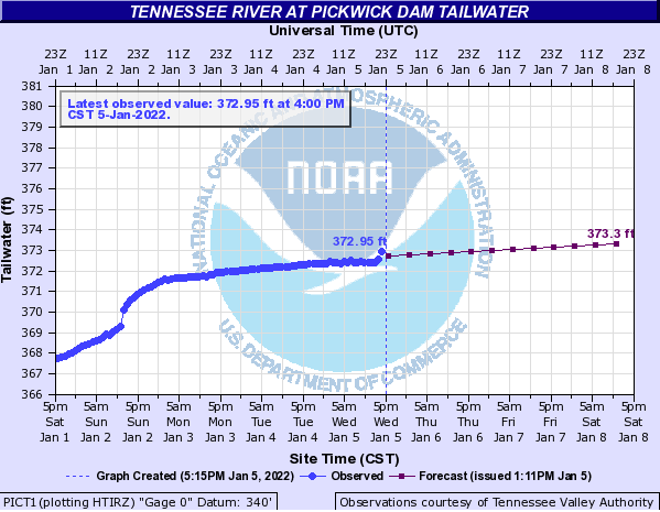
| Pickwick Lock posted 8 spillway gates open at Pickwick today [Jan 4, 2022]. Pickwick LockKeri Rowell Stanfield: How long they gonna be open?? [And those gates are not opened a small amount.] |
This was the graph their link provided:
 |
| hydrograph Dennis DeBruler commented on Keri's comment Following the above link, it looks like the Weather Service thinks the gates are going to be significantly open until Jan 10. |
This is the graph I got by using doing a search for Pickwick in a link I got in the Byrd Lock.
 |
| hydrologic |
This is probably the winter storm that caused the gates to be raised. It pushed the Ohio River up 20' in a couple of days at the Byrd Locks.
 |
| accuweather, accessed Jan 1, 2022 via DeBruler |
Pickwick Lock posted two photos with the comment: "TVA has opened some spillways this afternoon [Feb 19, 2022]."
Rick McNeil: What does that mean?,how many gates and how much are they open?,and what will it do to crump in terms of flood stage?
Pickwick Lock: As you can see in the photos, there are 4 gates partially open. At the current time the flow through the open gates is approximately 12,500 cubic feet per second. The total discharge is currently less than 100,000 cubic feet per second. The rise of the water at Crump, TN is somewhat dependent on the flow through Kentucky and Barkley Dams. As far as flood stage, you would need to ask TVA that question since they control the water flowing through the dams. This webpage is operated by the Corp of Engineers. TVA controls the electricity and water flow. COE manages the locks for TVA.
 |
| 1 |
 |
| 2 |
 |
| Pickwick Lock Screesnshot @ 1:08 M/V Frances R Keegan departing the lock, headed upbound. Great job by the entire crew. The timelapse video is a bit long, but is worth watching til the end. It will give you a perspective of how dangerous towboatin' can be. If an engine stalls/fails once they get above the protective walls, they could end up in the spillways. Watch how the current draws the towboat and tow to the port (left) in the video. The captain of the towboat had to use all of the towboat's power to overcome the draw of the river current toward the spillways in the dam. 🎥H.Soto & R.Boyd Pickwick Lock [They have had a lot of rain and a comment indicates that the outdraft is caused by a current of 200,000 cfs. At the end you can also see the water level in the lock go down.] A 0:21 real-time video showing the draw (current) that the above tow was fighting. |
Pickwick Lock posted two photos with the comment: "This is what 200,000 cubic feet of water per second flowing through the Pickwick Dam spillways looks like at night."
[This is the first time I've seen almost all of the gates open. And some of the gates are completely out of the water.]
 |
| 1 |
 |
| 2 |
 |
| Dennis DeBruler commented on Pickwick Lock's post Now I'll have to try to remember to access this page during a normal flow to see what the normal elevation is. https://water.weather.gov/ahps2/hydrograph.php?wfo=meg... Pickwick Lock: Dennis DeBruler the normal summer pool below Pickwick is 359.0 M.S.L. elevation, but according to how much water is being discharged at a given time, it can range from a low of 355.0 M.S.L. elevation to as much as 365 M.S.L. elevation. That is with average rainfall. If it floods you are seeing right now what happens. Pickwick Lock: Dennis DeBruler the normal summer pool above Pickwick is 414.0 M.S.L. elevation. We have been as high this time as 417.96 M.S.L. el. Minimum pool is 408.0 M.S.L. el. |
Two of the ten photos posted by Pickwick Lock with the comment: "The NASA Ship Pegasus locking through Pickwick Lock early this morning. 📸 H. Soto Pickwick Lock"
Dennis DeBruler: Can the bridge on the front of the barge can remotely control the towboat at the rear?
Pickwick Lock: Dennis DeBruler yes, it can also be disengaged so the towboat has control when needed.
 |
| a |
 |
| b |
 |
| Pickwick Lock posted Cool photo from the wheelhouse of the M/V Duke making a night time downbound approach to the main lock upper long wall. Thanks for sharing the photo Bobby Scheffer. 📸Bobby Scheffer, M/V Duke Crew and Company. |
Pickwick Lock posted two photos with the comment: "Nice relaxing day for fishing. Couple photos sent to us by Colby Hutton. Thanks for the photos. 📸 Colby Hutton."
 |
| 1 |
 |
| 2 |
Pickwick Lock posted five photos with the comment: "These photos were sent to us by the Pleasure Craft that locked through yesterday afternoon. Thank You for the photos. 📸 Pam Page Wolfe"
[At posted resolution]
 |
| 1 |
 |
| 2 |
 |
| 3 |
 |
| 4 |
 |
| 5 |
Pickwick Lock posted four photos with the comment: "Rocketship downbound out of Pickwick Main Lock."
Robbie Miller: Just curious, is that the biggest ship that comes through? Definitely a site to see!
Pickwick Lock: Robbie Miller LST 325 is slightly longer, but not as wide.
 |
| 1 |
 |
| 2 |
 |
| 3 |
 |
| 4 |
Dec 20, 2022:
 |
| Pickwick Lock posted Open spillway gates |
Dec 21, 2022:
 |
| Pickwick Lock posted Down to 6. TVA closed a couple of the spillway gates a little while ago. [And two of those gates are just partially open.] |
Pickwick Lock posted two photos with the comment: "Here are a couple photos taken from across the lake of the M/V Sheryl B Reeves as they are breaking the boat out from the tow and heading over to the Auxiliary Lock to lock lightboat downbound. Then go pull their barges from the Main Lock and complete the fast double lockage. 📸Phil Hollinsworth. Thank You for the photos."
Janet Patterson: Must be super windy, whitecapping
 |
| 1, cropped |
 |
| 2, cropped |
 |
| Pickwick Lock posted Teamwork at its best! The M/V Steve Richoux was having difficulty pushing their tow against the current up through the "buoy line" below the lock, so they gave the M/V St. Paul a call and requested assistance. Both Marquette vessels working together safely pushed the tow up to the lock. That is also a nice sunset in the background. 📸 John Carothers JereLewis Cox: Great picture, I’ve seen tows struggle to get upstream from the Rock Pile to the lock when the dam is pushing 80,000+. Glad he found some help. |
 |
| Mar 6, 2023: Damon Nabors posted TVA letting a few gallons go through today. Ron Bishop shared |
 |
| 0:17 video The spillways at Pickwick this afternoon [Mar 7, 2023]. This is what 160,000 cubic feet of water per second looks like when it is flowing through the spillway gates. That's 1,196,800 gallons of water per second. 🎥John Carothers |
I looked at a satellite image to see how big the auxiliary lock was and noticed the dam was spilling when the satellite went over. Note the well defined hydraulic jump in this image. I was curious when that image was taken so I fired up Google Earth to get a date for this spill. Unfortunately, I discovered that Google Earth has some serious errors because this same image was dated Jan 2020 and Feb 2021. There is no way two different days are going to have the same water turbulence pattern. BTW, the next oldest image, Dec 2015, was also spilling water. But not as much. I had to go back to Jun 2006 to find another spilling. And that image was repeated in the next image back, Oct 2005. And in Jan 1997.
 |
| Satellite |
2 of 6 photos posted by Pickwick Lock with the comment: "The RocketShip is downbound out of Pickwick Lock. The M/V Brooke McKensie was waiting lock turn behind them. 📸 John Carothers"
[The comments contain two videos of the RocketShip passing by, but they both have a profile orientation.]
Fort Loudoun Lock shared with the comment: "Another great post from our counterparts downriver at Pickwick Lock! 🙂."
 |
| 1 |
 |
| 2 |
2 of 7 photos posted by Pickwick Lock with the comment: "The American Serenade making their maiden voyage through Pickwick Lock last night [Jun 4, 2023]. 📸 Matthew Thurmond."
[Some comments indicate it is a cruise ship heading to Chattanooga.]
 |
 |
| b |
 |
| Gary Hillyard commented on the above post Got to see it in Savannah nice pic |
 |
| 1 od 7 photos posted by Pickwick Lock Wheelhouse view from the M/V Saviour as they passed through the main lock chamber at Pickwick. Thank you Darren Pertuit for the great photos. 📸 Darren Pertuit, M/V Saviour Crew and Company. |
These are two of a few videos showing the M/V Bobby Thompson working a downbound "fast double." I picked these two because they demonstrate a couple of interesting towboat maneuvers.
 |
| 0:38 video [This one shows the towboat sliding sideways. I've seen them do this in Mississippi locks, but I still haven't figured out how they do it.] |
 |
| 0:22 video [This one shows the towboat turning the tow to the starboard. My theory is that they can torque the tow to the starboard by running the port prop forward while running the starboard prop in reverse. This video confirms this because of the propwash we see coming from underneath the towboat on the starboard side. ] |
 |
| same video as above [A few seconds later, he is away from the wall and is gunning both props forward. In a few more seconds, he will back off the throttles.] |
Pickwick Lock posted two photos with the comment: "Spillways this morning. Current Pickwick River Data: Upper Pool: 414.5 Lower Pool: 371.3. Total Discharge: 120, 514 c.f.s."
Danny Mcclure: I've fished pickwick all my life,i dont think ive ever seen the very first gate or the last gate on the spillway opened, during heavy flooding.
Pickwick Lock: Danny Mcclure the two gates you mentioned are not actually moveable spillway gates. In 2019, TVA opened everything Pickwick could run water through.
Pickwick Lock: Thomas Kelso Pickwick reached 536,000 c.f.s. for about 5 hours in 2019.
Mark Turner: Pickwick Lock remember it well. My dock on Bear Creek still went under.
Tj Graham: Pickwick Lock I remember this the lake side was crazy the river bouys were almost under water and all the docks was submerged I caught a good smallmouth out of a woman’s rose bush in her front yard up on Alabama end peoples closets on their docks the doors was half under water and all their furniture I jokingly told guy with me that day I’m bout flip one out that guys picnic table I think I’ve still got some videos on my phone of some of it. [He provided three photos, but they have a profile format.]
Joshua Garrison: I think it will hit 200k this year. Since main chambers closed in March. What will your plans be for locking tows through small chamber? The draws gonna be a beast.
Pickwick Lock: Joshua Garrison as of right now, if the discharge rises above 120k, the auxiliary lock chamber will shut down as usual to all traffic. They are still working out details on the main lock closure.
 |
| 1 |
 |
| 2 |
 |
| Thomas Kelso commented in the context of the 2019 flood Aftermath. Water reached into second level of house. This is ground level. |
 |
| The Outpost Pickwick Lake & Dam posted UPDATE: Pickwick Dam Bridge Construction 2024 Based on the direct information we received yesterday the bridge repairs will not start until late summer of 2024 or early fall. In reference to the total lane closure that was first announced, this has been reduced to only a ( Single Lane Closure ) in increments of 1000 +/- feet per section at a time. This will be regulated by a temporary light that is scheduled in 3 minute intervals to keep the flow of traffic moving. We are very grateful that Jones Brothers Construction, TDOT and TVA have been able to reach a new method of renovation that will (NOT) require full closure. There is no question that it will be an inconvenience for many, because who likes to slow down? But maybe that's what we all need. Or, better yet what our country needs! Because it is easy to lose site of our foundation or what's holding us up if all we do is run without stopping to recall the foundation in which we stand. Ron Bishop shared |
 |
| Sean Brady posted Rotor Of Waterwheel For TVA Dam Pittsburgh, PA - Spider of Steel: Part of the huge rotor for the waterwheel generator to be used in the Tennessee Valley Water Works, built in the East Pittsburgh Works, Westinghouse Electric, this rotor will go into the TVA's Pickwick Landing Dam in the Tennessee River in Hardin County, TN. It will generate 40,000 kilovolt amperes or roughlt 54,000 electrical horsepower. Photo shows men working on wheel that dwarfs them in size. 1936 [My reaction when I saw that is the dam uses turbines, not water wheels. The following comments correct the description.] Kent Carter: I think that is the alternator rotor, not the water side. Chuck Patterson: Kent Carter Well, I don't know anything about this beast, but if it is the alternator rotor where are the windings? Kent Carter: Chuck Patterson they weren't installed in Pittsburg, I think. There was a large copper mine, smelting and wire making plant not far from the dam where this rotor was installed. It might have been wound there. Eugene Day: Chuck Patterson The winding segments would bolt on as an outer ring. This is just the hub and spokes. The rotor would be installed horizontaily (axis vertical) with a turbine rotor on a shaft extending below it. https://www.tva.com/energy/our-power-system/hydroelectric |
Kent provided a link to this post:
 |
| Tennessee Valley Authority posted Pickwick Landing Dam's unit 3 turbine is lifted out as part of a major upgrade and maintenance project. The 472,000-pound Kaplan turbine will be refurbished and reinstalled along with other major components of the power generating unit. Some of the equipment that will be replaced has been supplying low-cost hydropower since the dam was built between 1935-1938. Pickwick's six generating units have a capacity of 229 megawatts, enough to power approximately 134,000 homes. [229mw/134,000 = 1.7kw per home 1.7kw/120 volts = 14 amps That is just one air dryer. It doesn't make sense to me.] Jordan Brewer: Anyone care to tell me how to get the nose cone off with out getting under a load lol |
Tony Horton provided three photos in the comments:
 |
| 1 |
 |
| 2 |
 |
| 3 |
May 28, 2024:
 |
| Pickwick Lock posted Open come the spillway gates. TVA just opened 4 gates a small amount. Current total discharge for the powerhouse and spillways is around 78,000 c.f.s. |
 |
| Jerry Bevis commented on the above post, cropped 13 Gates at Guntersville. Sending y’all some water. |
And Pickwick got that water a day later.
 |
| Pickwick Lock posted TVA has opened 4 more gates for a total of 8. Total discharge, including the powerhouse and spillways is currently 91,500 c.f.s. at 0800 hrs. [So each gate is passing 3,375cfs.] Jamie James: That’s a lot of water. Pickwick Lock: Jamie James imagine what 536,000 c.f.s. looked like in 2019. David 'aka'bruno Garrison: Pickwick Lock a big flood downstream 👀👀cause we got flooded along with a lot of other people |
 |
| 27:52 video @ 18:51 |
2025 TVA Flood
Feb 9:
 |
| TVA posted We are watching a weather system that is expected to bring 6-8 inches of heavy rainfall to the Tennessee River Valley this week. In preparation, releases from the dams on the main Tennessee River will increase while the large tributary dams store water. Expect lake and river levels to rise as inflows increase throughout the week. Pickwick Lock shared |
 |
| Tennessee Emergency Management Agency posted We encourage all Tennesseans to monitor National Weather Service forecasts and take preparedness steps as multiple rounds of heavy rainfall will continue to impact the state. ➡️ Know your risk. Do you live near a flood-prone area? If so, what is your emergency and/or evacuation plan? ⛈️ Stay informed on changing conditions. 📳 Have multiple ways to receive alerts. Read more from TEMA: https://www.tn.gov/.../be-aware--excessive-rain--flooding... |
Feb 13: I waited for the 18-wheeler to appear to provide scale.
 |
| Pickwick Lock posted 1600 hrs. 13FEB2025. TVA has opened up spillway gates, but are in the process of shutting down generators. Total discharge at 1500 hrs is 149,000 c.f s. |
They were predicting a flow of 180kcfs for Feb 16, 2025.
I, and some of the comments on the above post, wondered why they shutdown generation. TVA added a comment that explains: "These generators can only generate electricity when there is enough head pressure (elevation drop) through the system to spin the turbines efficiently. There are a couple post on this thread that explain the process." I looked for those explanations, but I could not find them.
Even the Chicago Tribune had an article about this flood because it killed nine people in Kentucky. Most of them because they were in a vehicle that got swept away by a strong current.
Pickwick Lock posted three photos with the comment: "Just a little assistance please. The M/V Cadet assisting the M/V James E Jackson off the lower wall, heading downbound after lockage. Current water discharge 185,865 c.f.s. 📸 Micah Hurt"
Kathryn Robertson Campbell: We live near the Ohio River in Owensboro, KY. She is so angry. I haven’t seen the current this strong for several years. She hasn’t peaked, yet.
Watched them yesterday on the Ohio at Owensboro, KY. Heading to the Newburgh lock. Looked as if they thought they were in the Hydroplane races, and thank goodness for their escorts. Wondering how long till they close tows and string traffic till the water goes down. The little helper tow boats are amazing.
[Owensboro is significantly upstream from where the Tennessee River adds its water to the Ohio river.
(Update: TVAincreased the lake levels of the Kentucky and Barkley Lakes to help reduce the flood crest on the lower Ohio River. [Dennis DeBruler])]
Doug Hesson: It used to be a point of pride for line boat Captains & Pilots to not need an assist into or out of locks, unless there was a LOT of water running or wind blowing.
Pickwick Lock: Doug Hesson the towboats will probably tell you that 185k c.f.s. at Pickwick is considered a LOT of water. It is very difficult for even the most high powered towboats to get off this wall with these current water conditions as a lot of the water flows from the spillways over to the lower long wall. This towboat took the smart way to leave the lock wall. They were probably doing 9-10 knots by the time they reached the river bend below the dam. We've been told that it is a pretty wild ride down through the buoy line in these conditions.
Patrick Irwin: Pickwick Lock It's especially difficult with hip barges. You risk breaking them off trying to steer off a long wall.
Stephen Lewis: I bet that's a strange feeling getting pushed into that current and then just taking off power sliding around the bend... probably a little nerve wrecking, too.
Stephen Christopher Ritchie Sr.: Stephen Lewis it was def a wild ride we got off them barges and back in the boat quick like when we got off that long wall lol.
Rhonda W. Thompson: These guys are working hard look at the smoke!
Jill Shearon: Is it harder for them to navigate with high water?
Ronnie Lewis: Jill Shearon in that particular stretch it is but there are places that it is considerably easier with the higher water
Martha Kail-Henderson: Will they stop barge traffic if the water gets higher?
Pickwick Lock: Martha Kail-Henderson yes, but we are not at that point yet.
Joshua Garrison: Pickwick Lock what's that point? When has that happened?
Pickwick Lock: Joshua Garrison in 2019 Pickwick shut down the lock downbound at 250k after two downbound towboats had severe issues getting around the bend below us. One other got turned around above us with a couple barges. Pickwick was shut down the same year upbound when the waves were crashing over the lower approach walls. We got up to 536k discharge for a few hours that year.
 |
| 1, 2 was a duplicate of 1 MorrisandClara Worlds: This is tied up behind Randy and Leann’s house😄 |
 |
| 3 |
I don't know what the discharge is for this image, but the water turbulence does show how the current would shove a tow towards the left descending bank.
 |
| Satellite |
Feb 17, 2025: Pickwick posted the comment:
1100 hrs. 17FEB. Pickwick Main Lock is currently still open for both upbound and downbound lockages.The Auxiliary Lock chamber will remain closed until the total discharge falls below 120k c.f.s.
[I was wondering if upbound traffic could make headway against the strong currents.]
Mark Jones: Just curious why does the total discharge affect the auxiliary lock ?
Pickwick Lock: Mark Jones it is next to the spillways. Before the current main lock was built, there was a floating boom wall that helped protect and change the direction of the discharge when flowing past the lower lock wall. That boom wall got damaged and was removed years ago and by the time we reach 120k, the current in the lower approach of the aux. lock is strong enough to push towboats sideways, making it difficult for them to enter the lock chamber, causing safety concerns. Since the aux lock is not needed with the larger main lock available, we shut it down and don't use it.

%20Facebook.png) |
| Pickwick Lock posted |
So this is what 125kcfs looks like.
 |
| Pickwick Lock posted 0500 hrs. 25 Feb. Pickwick |
If you look at 2025 TVA Flood, the flows for the dams on the Ohio River fall back to normal levels in a few days. But the predicted values above are still a heavy flow. But they are reduced to a level that allows them to open the auxiliary dam. Lets call 120kcfs the maximum manageable flow. And this shows that they will sustain that flow for several more days.
 |
| noaa |
The reason for the sustained high flows is that the TVA has several large reservoir dams up in the mountains. They would not be spilling during the rain events themselves. They would be allowing the reservoir lake to rise. But after the rain runoff was worked its way down the Tennessee River, the reservoir dams will start spilling. The amount they spill will cause the maximum manageable flow at Pickwick and the other river dams.
Mar 6, 2025:
 |
| Pickwick Lock posted And then there were none. All spillways at Pickwick are closed. 1100 hrs. 06MAR. [They have been posting photos every few days of how many gates were still spilling.] |
Are those fluctuations in the tailwater height caused by the hydropower plant's discharge?
 |
| noaa |
Back to generic lock information
Don't worry, the boat has just a couple of dummies and some cameras for producing a safety video.
 |
| Tennessee Wildlife Resources Agency posted Stay safe by keeping your distance and always wearing a life jacket. Check out this video for important boating safety tips! Pickwick Lock posted Filmed at Pickwick Dam. Worth watching to the end of video! CaptainJoey Bourque: I remember a couple going through Pickwick lock back in the 80s she lived but he didn’t. David McNabb: CaptainJoey my friend and me were fishing below the dam when that happened. I remember the little ski boat being tore up. |
Tennessee River Locks & Navigation posted five photos with the comment: "🚧🚧 Notice To Navigation, Pickwick Lock Main Chamber, Tennessee River Mile 206.7 will be closed as of July 7, 2025 thru October 7, 2025, for upper gate rehabs with no openings. The auxiliary chamber will remain open to navigational traffic for the duration of the project. 🚧🚧 Army Corp of Engineers Boats M/V David C. Russelburg, M/V J.C. Thomas, HCF, R3F & Service Barge # 18 are getting ready for the work to commence.🏗"
Ben Stalvey: Manitowoc Crane on barge. What model number?
Stephen Porter: Ben Stalvey MLC-300
Ben Stalvey: Stephen Porter Awesome who owns that one?
Stephen Porter: Ben Stalvey Regional Rivers Repair Fleet (R3F) Heavy Capacity Fleet Unit (HCF). They just completed work at Wilson. The HCF’s SHREVE heavy-lift crane is also at Pickwick and will be used to hold miter gates during this maintenance cycle.
 |
| 1 |
 |
| 2 |
 |
| 3 |
 |
| 4 |
 |
| 5 |
This is probably the SHREVE unit that Stephen Porter mentioned.
 |
| Scotty Brewer commented on the above post, cropped |
7 photos of the Rocketship going downbound through the Pickwick Lock
Around 0:30 in this video you can see the towboat going sideways to get behind its tow.
[I don't understand how they can go sideways. I confirmed that St Paul is a twin screw rather than a Z-drive.]
0:23 timelapse video of a tow approaching the downstream side
4 photos of the RocketShip going through the auxilary lock
12 photos of the RocketShip going downbound in Jun 2022
12 photos of the RocketShip going downbound in Jan 2023
17 photos of the lock dewatered
No comments:
Post a Comment