(Satellite, the industrial area between the tracks & 47th and Ashland & Halsted)
See Union Stockyards "L" Branch for more photos of the stockyards.
 |
| Bill Molony posted Union Stock Yards on the south side of Chicago, circa 1940. Nearly nine million head of livestock were received annually at this massive facility. It was "The Live Stock Market of the World" back then. Stuart Pearson It was a MASSIVE PLACE. When I was in HS every Boy HAD to take 6 Weeks of each of the Shop Courses offered at the School. Auto, Machine, Print, Electrical, Wood, and Agricultural. Agricultural, or AG as we called it was o requirement because of all the Boys that came to JTHS from the New Lenox, Frankfort, Elwood, and Manhattan areas. We did take a Field Trip to the Stock Yards and actually viewed the activity on the "Killing Floor." As a result I found it difficult to Eat Meat for awhile after that experience. The AG Building was located on the Southside of Jefferson St. where the Tennis Courts are now. IOt was an old Red Brick 3 story structure that would actually S~H~A~K~E when a Rock Island Freight Train pulled by a 5000 Class 4-8-4 came by. Bill Molony posted again Chicago Union Stock Yards post card picture post marked January 28, 1943. Craig Sanders How in the world did they keep it all straight?! Todd VanSlyke Paper and pencil and a handshake. Jim Arvites posted BRHS posted |
 |
| Bill Molony posted Map of the Union Stockyards & Transit Company railway lines 1865-1898. Dennis DeBruler One needs a "decoder key" when looking at these old maps. CM&N was Chicago, Madison & Northern. It was bought by IC to gain direct access to their original charter line in Freeport. CTT was Chicago Terminal Transfer and became the B&OCT. CCC&StL is better known as the Big Four. Chicago & Atlantic must have become the Erie. Robey St. became Damen Ave. Charlie Vlk CM&N was never an independent road; just a construction name. Little known is that the IC used the Chicago & Aurora/CB&Q to reach Chicago as construction of the main line and Chicago Branch spanned a number of years. Traffic was routed from Mendota and later the Iowa traffic came in over the C&I to Aurora. This even went back to before the CB&Q had their own line into Chicago and caused some friction with the C&NW which had operated the IC Freeport segment and had traffic agreements with the CB&Q that were contested. [There are also some comments about when did Santa Fe build there own passenger tracks south of the IC tracks. Chicago, Pekin & Southwestern is the railroad that Santa Fe bought to gain access to Chicago. ] BRHS posted Jon Roma: Who produced this interesting map? Bob Lalich: Jon Roma - this map is found in the book Erie Lackawanna: The West End Volume 1 by Bernard Sennstrom. It is sold by ELRHS. Seth Lakin: Pre straightening of the Chicago River. |
Chuck Edmonson posted two images with the comment:
Here's hoping everyone had an enjoyable holiday.It was an odd date to set for the opening of one of Chicago's largest and oldest economic engines, but on Christmas day in 1865, the Union Stock Yard & Transit Co. would begin operations.Chicago was no stranger to meat packing and a transit point for livestock, as early as the 1840s several smaller stockyards were scattered around the city as well as the old Bulls Head Stock Yards located near Madison and Ogden Avenues. These smaller yards were probably an unpleasant sight and smell for residences surrounding them, with livestock being herded through existing public streets and the congestion it caused.The area bounded by Pershing (39th) and 47th Streets and Halsted on the east and originally Racine (in time to expand west to Ashland) on the west was sufficiently away from and just outside city limits at that time, and offered access via various rail lines that ran nearby, the original 320 acre site offered an ideal location for the consolation of operations.One of the key factors was the formation of the Union Stock Yard Transit company, a consortium of nine railroads which would oversee rail movements within the yards itself and would run the daily operations within the yards, allowing for efficient movement both into and out of the facility.As big packers like Swift, Armor and Wilson came on board, and refined their operations into assembly line-like efficiency by the beginning of the 20th Century over 25,000 would be employed and around 80% of all of the nation's fresh dressed meat would be shipped from the Union Stockyards, that had by now expanded to become a 475 acre site.For over 70 years Chicago would be the hub of most major meat packing operations in the country, but slowly operations began to move westward, closer to the feedlots and ranges where cattle were raised.In 1971 the Union Stock Yards & Transit Co. would be dissolved and major operations in the city would come to an end. A couple of small independent packers can still be found there but the site has been transformed into a major industrial park. Today there are few reminders of this historical and behemoth piece of Chicago history, save the old Stockyards Gate near 43rd and Halsted.Pictured are the original stockyards plan and a look at how the yards appeared in its' infancy in 1866.
 |
| 1 |
 |
| 2 |
(Update: details about Swift & Company The successor was Chicago Junction. When the Chicago Junction, along with the other railroads, was forced to elevate its tracks, it built a passenger route separate from its freight route and leased the passenger route to the CTA in 1907. The shuttle service between the CTA's Indiana Avenue Station and the stock yards was called the Stock Yards Branch. The passenger route west of the station was the Kenwood Branch.)
In 1865, the western boundary of Chicago was Western Avenue, and the southern boundary was Pershing Road. This was the year the Union Stock Yard and Transit Company of Chicago (USY&T) was incorporated to consolidate the Chicago stock yards. They acquired swampland south of Pershing Road to build the yards and built a railroad outside the city limits to connect all nine railroads entering Chicago south of Roosevelt Road to those yards. (Wikipedia) The nine railroads that had maintained stock yards (listed below) helped finance the Union Yards and closed their own yards. (FTC) By 1870, Chicago had extended its boundaries to include the stockyards, and the yards were processing 2 million animals a year. By 1890, the number was 9 million. In the early 1860s, the meat-packing industry was located in Cincinnati, Ohio. By the 1870s, the industry had moved to Chicago.
 |
| Brian Berthold posted the craziness of the Union Stock yards |
The resulting meat packing industries were some of the largest industries in the world at the time. Philip Armour was the first person to build a modern large-scale meatpacking plant in 1867.
This new plant employed the modern "assembly line" (or rather dis-assembly line) method of work. The mechanized process with its killing wheel and conveyors helped inspire the automobile assembly line that Henry Ford popularized in 1913. For a time the Armour plant, located on a twelve (12) acre site, was renowned as the largest factory in the world. In addition, hedging transactions by the stockyard companies was pivotal in the establishment and growth of the Chicago-based commodity exchanges and futures markets. (Wikipedia)The USY&T railroad was the second of six hub (belt) railroads in the Chicago area. (St. Charles Air Line was the first.) It connected the following properties:
- Starting west from Illinois Central and Michigan Central
- Michigan Southern & Northern Indiana (later the Lake Shore and Michigan Southern, then NYC) and Rock Island & Pacific
- Pittsburgh, Fort Wayne & Chicago (later Pennsy)
- The stock yards
- It then turned northward and paralleled the Chicago & Great Eastern's line (later Pennsy) in Campbell Avenue
- Chicago & Alton at Brighton Park Crossing
- Chicago, Burlington & Quincy
- Chicago & North Western Railway at Ogden Avenue
I labeled this post as rrNYC because, even though it started out as a union railroad, Vanderbuilt later got control of the railroad. And when Conrail was split up, NS got this asset. The route is intact except for the segment between the IC and RI. I include a 1938 aerial image to indicate where that segment used to run.
 |
| ILHAP |
In the photos below, note that the canal along the north side of the yards no longer exists. The rail yard is now a 4-track corridor along Pershing Road. In 1971, most everything in the area bounded by Pershing Road, Ashland, Halsted, and 47th Street was demolished and redeveloped as an industrial park. One structure that was not demolished was the main entrance gate.
 |
| LoC: 1878: Packing houses in the distance. Covered pens for hogs and sheep; open pens for cattle. Area of yards, 75 acres; 50 miles railroad tracks. Daily capacity: 25,000 head cattle, 160,000 hogs, 10,000 sheep, and 1,000 horses. |
 |
| LoC: 1901 |
 |
| Lynda Pownall-Carlson posted John Sevick: Was this taken from a plane? Lynda Pownall-Carlson: John Sevick My Dad did use helicopters to take photographs. I was to young to know how this photo was taken. He had a commercial Photographer business on Armitage Ave in the 60s and 70s Paul Webb shared Tom Lampman: In my early days with the MILW we still hauled cattle cars to Bensenville and then a transfer job took them the rest of the way here. |
Gregory Mikosz posted five pictures. His comments include:
Drovers herded cattle, hogs, and sheep down two wide thoroughfares from the railroad cars to the pens. From the Civil War until the 1920s and peaking in 1924, more meat was processed in Chicago than in any other place in the world. Evolving methods of transportation and distribution led to declining business and the closing of the Union Stock Yards in 1971.
 |
| One of 14 photos posted and shared by Mike Breski [The comments for the 14 photos were copied from wikiwand] Not far from the famous Chicago stockyards, these cattle carriers sit on a back track in Conrail's Ashland Avenue Yard in October 1984 Timothy Leppert My Brother was a manager for the Railroad and used to allow the Jewish Rabbi to Bless the cattle as part of their religion while they were parked there. Mike Breski We had Rabbi Lipshitz he would assure animals were being treated according to kosher standards for the ones consigned to kosher packing houses. |
 |
| Jeff Nichols -> Forgotten Chicago |
 |
| Kenneth Andresen -> Forgotten Chicago |
The Entrance Gate to the Union Stock Yards, postcard from ca. 1920 (located at S. Peoria St. and W. Exchange Avenue).
The Union Stock Yard Gate, was the entrance to the famous Union Stock Yards in Chicago. The gate was designed by John Wellborn Root of Burnham and Root around 1875.There are a lot more pictures in the comments for this posting, including:
 |
| Frank Pajak |
 |
| Frank Pajak: "1893 Sausage." |
 |
| Historic Chicago posted Union Stockyards, Chicago (1910) |
 |
| Sharon Avendano shared a David M Laz post December 27, 1865 – The first shipment of hogs arrives at the Union Stockyards, opened officially just one day earlier. The vast facility that would come to occupy land bordered by Pershing Avenue, Halsted Street, Forty-Seventh Street, and Ashland Avenue, got its start in 1864 when nine railroad companies purchase 320 acres of swampland on the southwest side of the city. Vince Mietlicki Worse than the stockyards were the meat packing plants located in Bridgeport near so-called Bubbly Creek. Tee-Pak made sausage liners/wraps and put tons of emissions into the the nearby neighborhood. I think it was sulfur dioxide or carbon disulfide used in the making of those packages. Of course, this was in the 60s before EPA existed. Dave Baker At the end of the Cival War Chicago was part of Wisconsin https://www.wpr.org/chicago-wisconsin-how-windy-city... [Dave did not read the article. The boundary was moved as part of the state's admission in 1818 to encourage trade with the northeast to balance the pro slavery sympathies in southern Illinois.] |
 |
| Ted Okuda posted August 22, 1956: A fire at the Union Stock Yard. |
 |
| Bruce Moffat posted Bob Lalich Very cool! I have not seen many action shots within USY. |
 |
| Jon Oye -> Original Chicago One of the things Chicago was once known for. Postcard. Curteich-Chicago "C.T. Art-Colortone." Aero Distributing Co., Chicago. |
 |
| Jesse Cordero posted, Kenneth Swedroe posted Chicago stock yards, 1947. [From a redundant posting:] Turk Meyers Every pen had an "address" so they documented and kept track of livestock. George Coy also posted The maze of livestock pens and walkways at Chicago's stockyards, ca. 1947 Library of Congress Gregory Fruhauff posted David Konopacz posted Tom Jopek posted [A lot of comments about the smell.] Kathleen Murphy Golden posted Vanished Chicago posted |
Obviously, the following is a colorization of the above.
 |
| Jeffrey Linmark shared his post [There are so many comments that I didn't bother to read them.] |
 |
| Kevin Ahern posted I was driving west on the Eisenhower yesterday evening and passed a semi loaded with live hogs. (I can’t recall the last time I saw a livestock truck on the Chicago expressways). Seeing that reminded me about the history of the Union Stockyards. “Hog butcher to the world.” Jay Lyden: One summer I was a toll collector and my trainer told me to always close my door when a livestock truck came through. I always did and found out why one day when a driver missed a shift and upset the hogs. I closed the lane while maintenance came out and hosed off the booth. I skipped lunch. [There are some more tool booth stories.] |
 |
| Mike Breski shared Union Stockyard & Transfer Co RailroadRich Benko I worked at the last standing Swift & Company plant in the Chicago stockyards 1970-1972! |
 |
| Kenneth Swedroe posted The union stock yards, Chicago is.. from the song, my kind of town, Chicago is. Robin Lavin Wasn’t it near a large train station? I think I took a train there to Ohio...Dennis DeBruler That was probably the Englewood Union Station down by 63rd, https://towns-and-nature.blogspot.com/.../chicago-il... |
 |
| D Clock Oest posted [Did somebody go up in a balloon to sketch this aerial view? Or could they imagine what it looked like by walking all around the area?] |
All of those animals would drink an awful lot of water.
 |
| Mary St. John posted |
 |
| Daniel James Springer posted The "billionth animal" arrives at the Union Stock Yard in 1954, the poor bastard. |
 |
| Kenneth Swedroe posted union stock yards, early 1900's |
 |
| Glen Miller posted Armour was the most famous of the meat packing businesses in Chicago. It helped make the city a center of the meat packing industry in the U.S. As the herds of cattle reached the end of the trail, they were loaded onto the railroad cars and shipped to Chicago "on the hoof" for slaughter. Beef was packed for shipment to grocery stores and butchers in refrigerated cars developed in the 1870's using ice. Chilled refrigerator cars and ships then created a national industry in vegetables and fruit that could previously only have been consumed locally. |
 |
| Jeff Nichols posted Boardwalk through the corrals at the Union Stockyards, 1904. Chicago History Museum, DN-0000986 |
 |
| Windy City Historians posted Chicago Stockyards, 1970. It closed in 1971. Photo by Don Casper (Vintage Tribune) [A true urban cowboy.] Xavier Quintana posted with the same description |
 |
| Mel Herweck posted June 14, 1831 William G. Butler, one of the earliest and most active cattle trail drivers, was born in Mississippi. He moved to Karnes County, Texas in 1858 and after the Civil War ended, he began driving $4 cow to Abilene, Kansas' railhead where he sold them for $40 a head in the spring of 1868. He helped get railroad through Karnes County where he died June 20, 1912. [I did not realize that Santa Fe built towards Denver before it built towards New Mexico.] |
From an aerial photograph taken 11/29/1930. Photos are of the Chicago stock yards! The photographs were digitized by the Illinois State Geological Survey at the University of Illinois at Urbana-Champaign. Best viewed on a large screen.
Special thanks to Jon Roma of the Forgotten Chicago group!
 |
| 1 |
 |
| 2 |
 |
| John Smatlak Flickr (source) CR&I 9811 switching Hygrade Meat Plant 1960 Donald Anderson for USPRRC If you haven't treated yourself to a look through the Cornell University Digital Collections website, you really must do so. Take for example this gem showing Chicago River & Indiana 9811 switching Hygrade Meat Plant in 1960. This is in the Chicago Stockyards area, this view looks north on Emerald Ave. from the Chicago Junction Railway elevation. The Hygrade Meat Plant building is still there today. Thanks to Bob Lalich for figuring out the location. Citation: U.S. President's Railroad Commission Photographs #5003 P. Kheel Center for Labor-Management Documentation and Archives, Cornell University Library Here is the page where this particular photo is found: digital.library.cornell.edu/catalog/ss:20434123 |
 |
| Original Chicago posted Stockyard logistics. Most of the assembly line techniques used in the slaughterhouses were gravity powered. For this reason cattle’s would be driven up covered ramps before entering the facilities. It was the weight of the cattle that powered the movement of the production line. Kenneth Smith: It was the inspiration for the Model T assembly line, except that parts were added rather than removed as the line moved along. It also inspired Berry Gordy to create Motown's hit record factory. William Shem: Looks like a 1930s/40s truck. History's Canvas posted June 1941. Trucks at Union Stockyards. Chicago, Illinois. Photo by John Vachon for the Farm Security Administration. |
The man on the sidewalk in John's photo is about where the grade for the underpass ends. So the first curb indentation in the right in this street view is where the tracks used to enter the street.
 |
| Street View |
I've seen so few photos of stock cars that I thought I should save the ones I do come across.
Mike Breski posted a lot of material copied from wikiwand. The comments are interesting because they discuss CB&Q's Sheep Yard and Dial Soap in Montgomery, IL. Some also discuss cattle car movements in the 70s and 80s.
Don Wagoner The old heads said meat trains during the war on the IC had rights over everything including passenger.
 |
| Mike commented on his own post Conrail cattle cars Brighton Park, IL Not far from the famous Chicago stockyards, these cattle carriers sit on a back track in Conrail's Ashland Avenue Yard in October 1984 |
 |
| Raymond Breyer posted Phil Nichols I remember the smell as a little kid (1964+?) going by the NKP Livestock yard and Deckers Hog Market in Charleston Illinois. On Seventh Street NE of the NKP & NYC diamond. |
 |
| John Stell posted TP&W 1518 stock car at East Peoria Yard on 4-1-55. Monty Powell slide John Stell collection. I can remember getting livestock from AT&SF. Destinations were Speer Illinois via Sommer C&NW, Schwager on east end of TP&W and somewhere else. David Jordan  Several consecutive TP&W annual reports in the 1950s show a fleet of 20 stock cars, which were leased, IIRC. I had assumed they were part of a pool, possibly for overhead traffic. The late Jim Thomas mentioned unloading cattle at Effner for water, feeding and resting as late as 1964. I've long wondered if TP&W was involved in the movement of South Texas steers from grazing areas in OK and/or KS to King Ranch's Buck & Doe Run Valley Farms in southeast Pennsylvania (ATSF-Lomax-TPW-Effner-PRR). Movement by rail apparently ended around that time. Several consecutive TP&W annual reports in the 1950s show a fleet of 20 stock cars, which were leased, IIRC. I had assumed they were part of a pool, possibly for overhead traffic. The late Jim Thomas mentioned unloading cattle at Effner for water, feeding and resting as late as 1964. I've long wondered if TP&W was involved in the movement of South Texas steers from grazing areas in OK and/or KS to King Ranch's Buck & Doe Run Valley Farms in southeast Pennsylvania (ATSF-Lomax-TPW-Effner-PRR). Movement by rail apparently ended around that time. |
Dave Durham posted twelve photos with the comment: "In the early 1900s, the Chicago Junction Ry. was busy with line elevation work; these pics from the 1905 Ill RR& Whse Comm report are awesome for their documentation of old Chicago...does ANY of this line remain?"
Steve Malachinski The Chicago Junction (CJ) now Norfolk Southern does exist in part. The tracks run from a connection at Ogden Jct. with the UP (CNW) Rockwell Sub. to CP518 which is the old 40th st jct with the old CWI. Not sure if any of the track which goes under the old CWI, Pennsylvania main lines is still in service.
Ned Carlson According to this page, most of the embankment (which was also used for the Kenwood L branch) is still there.
http://www.chicago-l.org/operations/lines/kenwood.html
Matt McClure Yes; it is so odd to see the embankments and concrete all over the place with no rails.
David Daruszka I believe the tracks still run east from the old CJ yard as far as the wye at Root Street on Metra's Rock Island District. Beyond that the tracks (and bridge that carried then over the Rock) are gone.
yson Park Case Paper at 45th and Morgan in the former Stockyards area gets boxcars from NS on former CJ trackage and Vantage Oleochemicals gets quite a few tank cars at 47th and Racine, also off the former CJ and now served by NS in the former Stockyards. Ashland Cold Storage at 43rd and Ashland has an intact former CJ spur that still connects to the NS but it has not gotten a rail delivery in some time.
 |
| 1 |
 |
| 2 |
 |
| 3 |
 |
| 4 |
 |
| 5 |
 |
| 6 |
 |
| 7 |
 |
| 8 |
 |
| 9 |
 |
| 10 |
 |
| 11 |
 |
| 12 |
 |
| Paul Meier shared a Shorpy link, this copy is from LoC Dennis DeBruler This is one of many taken by John Vachon in 1941 and Jack Delano in 1943.https://www.loc.gov/search/?in=... |
 |
| 1907 Photo from LoC |
 |
| Paul Meier shared Dave Gudewicz Wonder what the tower in the middle of the image was used for. Nice image. Dave Gudewicz 'L' station story here:https://www.chicago-l.org/stations/exchange.html Dave Gudewicz For those interested, here's a nice article on the Stock Yard "L" branch which includes a history of the yards.https://www.chicago-l.org/operations/lines/stockyards.html |
 |
| Bob Lalich commented on Dave's comment concerning the tower. |
 |
| Dennis DeBruler commented on Paul's share The TIFF resolution of 13629x10488shows the blurriness of the letters. It doesn't help that much when trying to read the letters. It appears that semi-trucks back then were 10-wheelers instead of 18-wheelers. Paul Musselman There were some trailers with 8 wheels...depended on hauling requirements....Beer and Long-Haulers, mostly... |
The world renowned (and once major tourist stop - including visitors such as Rudyard Kipling, Sarah Bernhardt, Edward, Prince of Wales and Marlene Dietrich) Union Stock Yards, in the summer of 1941. The operation would only last thirty more years, closing at midnight on July 30th, 1971.Todd Protzman Davis shared
Kevin Watts Imagine the smell?
Zachary Taylor Davis - Chicago Architect Kevin Watts, indeed, the smell was notorious. At one time 18 million livestock (that’s a lot of manure) were processed annually. The Tribune once wrote, "It was an elemental odor, raw and crude; it was rich, almost rancid, sensual, and strong. There were some who drank it in as if it were an intoxicant; there were others who put their handkerchiefs to their faces.”
Phyllis Cerel You could die from the smell waiting in line for a concert at the International Amphitheatre.
Frank A. Icuss With a south wind, it could be smelled in Lake View, eight miles away.
John Long So many cities had stockyard districts. We also had one in Kansas City with similar photos to Chicago's that employed many immigrants from Croatia and other European cities who moved across the Missouri/Kansas state line to an area of Kansas called "Strawberry Hill". Now the area is called the Stockyards District and it's full of old building and new loft developments.
 |
| 1 |
 |
| 2 |
 |
| 3 |
 |
| Zachary Taylor Davis - Chicago Architect commented on John Long's comment on Todd's share John Long, indeed, Zachary Taylor Davis designed this plant for Schwarzschild & Sulzberger in 1898. At this point in time he had become the "go to" architect for packing houses across Chicagoland and the country at large - stemming from his previous experience as architect in residence for Armour & Co. and his use of the latest materials and appliances in construction. These materials included steel and concrete, which would factor large in the design and construction of his ballparks, further down the road. John Long Zachary, that's interesting. I used to lease office space in Kansas City's Livestock Exchange Building that survived the Livestock district going away, but the building is still there full of great architecture and history. They even had a bank and post office in the building but now it's just office space for artists, non profits, lawyers and all kinds of other small businesses. The hallways are very wide and I was told it was because they actually would sometimes have livestock in the building itself. https://livestockexchangebldg.com/ |
The legendary Chicago Union Stockyards became the start of some of the earliest big international food companies. Both the rise and fall of the stockyards have become an important part of Chicago's history.Nathan Mackey The tell tales still hang before the bridge under the C&WI & PRR.
From the Civil War until the 1920's and peaking in 1924, more meat was processed in Chicago than in any other place in the world. Construction began in June 1865. Many thousands of immigrants flocked to Chicago for new meatpacking jobs. The yards closed for good at midnight on Friday, July 30, 1971, after several decades of decline during a revolution in the meatpacking industry involving better transportation, labor, and wholesale costs.
At first, the major meatpacking companies resisted change, but Swift and Armour both eventually surrendered and vacated their plants in the yards as early as the 1950's. In 1971, the area bounded by Pershing Road, Ashland, Halsted, and 47th Street became a new diversified industrial park in an attempt to save many jobs that were lost.
I once worked on the railroads that still are remaining in the old stockyard area.
Tyson Park Does Ashland Cold Storage still get reefers at 43rd and Ashland in the old stockyards area?
Kevin Piper posted
Robert Buergermeier The smell lasted 10 years longer then the stockyards did.
 |
| 1 |
 |
| 2 |
 |
| 3 |
 |
| 4 [The train is approaching the CJ Butler+NS CP518+C&WI 40th+Pennsy Root Tower crossing.] |
 |
| Flora Elizabeth posted In 1903, 43 saloons were recorded in 2 blocks of Ashland Ave near the Stockyards…Chicago, the city that drinks. Drew Henderson shared James McKittrick: You need to know that those places were the social clubs, gathering places and banks of that day |
A video concerning the stock yards from C&NW's perspective.


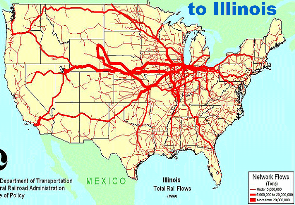
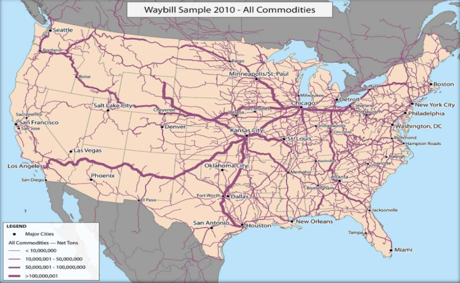


.jpg)


