 |
| Larry Retzl posted Photo of Grand Central Station . Thomas White I took one from about the same angle - 45th floor of the Board of Trade building...takes hanging out the open window. |
 |
| Dennis DeBruler commented on Larry's post And of some freight houses. I tried boosting the shadows and reducing the highlights. |
 |
| 1953 Englewood Quadrangle @ 1:24,000 |
 |
| Satellite |
 |
| Street View |
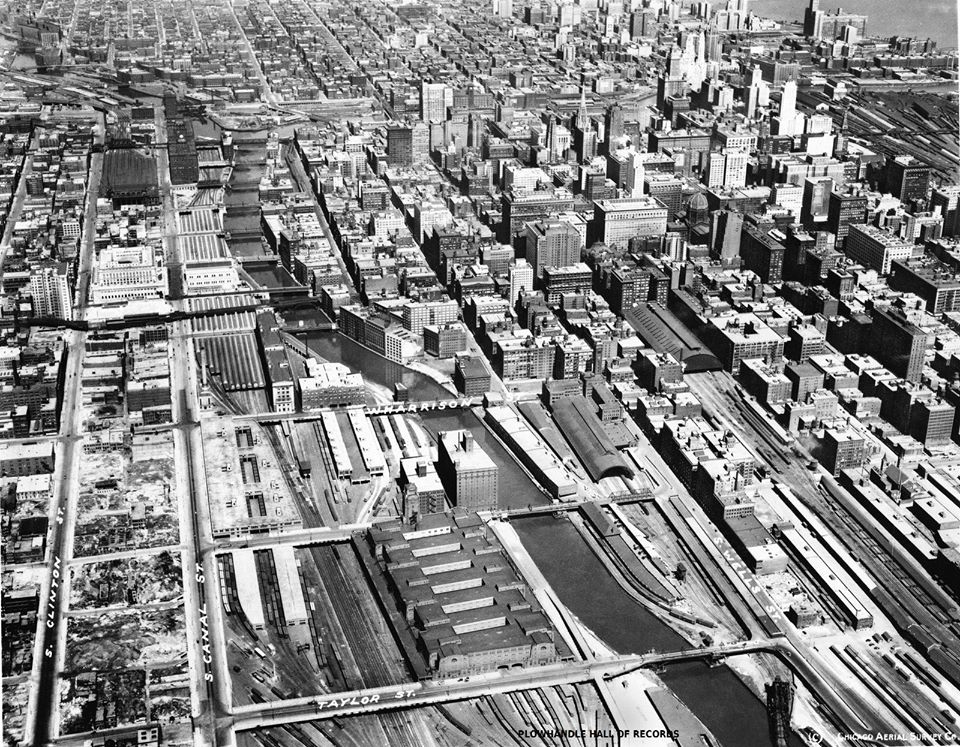
I posted the above images with the comment:
The first photo was posted by Larry Retzl. The second one is after I brightened the shadows and darkened the highlights. Not only does this photo put the headhouse, tower and train shed of Grand Central Station in context, it shows where the Chicago Great Western Freight House was. But what is the tall building on the other side of the river? Beyond that building was Pennsy's freight house. Chicago & Alton had a freight house out-of-frame to the right. (It still stands, https://www.google.com/maps/@41.8750194,-87.6355206,186a,35y,270h,44.97t/data=!3m1!1e3) Was the building north of Polk Street another C&A facility?I noticed the two barges parked by the former location of the CGW freight house. So after 70 years, the Grand Central Station land will be more than a weed field.Rick La Fever That tall building is the Union Station Power House, I think.
That might explain the barges too. They brought in coal for the boilers.
Timothy Leppert That powerhouse was once owned by Thomas Edison and the Steam it produced drove steam engines in the basement of Union Station that ran large electric generators. Last time I was down there they were still there.
 |
| Dennis DeBruler commented on Rick's comment on Dennis' post The barges are contemporary. It is not unusual for a contractor to bring in barges for a riverside development, especially to hold a crane. In fact, it looks like they are building a crane on the northern one. Sometimes the crane is already assembled when they bring it in. https://industrialscenery.blogspot.com/.../manitowoc-mlc... |
 |
| Dennis DeBruler commented on his post I meant the building directly across the river. Although the power house running generators in the basement of Union Station is interesting. I always assumed the pipes you see along Taylor Street Bridge in old photos was for steam heating in Union Station. I also assumed that Pennsy used the steam in their coach yard since the power plant is so far south of Union Station. I know CB&Q also had a power plant down around 14th Place and Canal. And of course they also had big coach yards down there. The Union Station power house is still standing, but I saw an article that Amtrak wants to tear it down in favor of a parking lot. https://www.google.com/.../data=!3m1!1e3!4m5!3m4... Tom Skowronski One of them was 310 W. Polk, home of the "Play Tripoli" sign painted on the elevator penthouse. I was in there in the mid 70s, and they actually manufactured the Tripoli game there. Those towers were torn down in the late 80s-early 90 as part of the new Main Post Office project. Dennis DeBruler So the buildings were effectively high-rise factories. |
 |
| Dennis DeBruler commented on his post The shadows indicate not only were the skinny rectangle and trapezoid on the topo map tall, they both had towers. https://clearinghouse.isgs.illinois.edu/.../0bwq08049.jpg |
 |
| Patrick McNamara commented on Dennis' post Geez, Dennis - gazing at SHADOWS from 1200 feet ? Here's a photo from the early 20s with your mystery buildings a bit more visible. Dennis DeBruler And it has a nice view of Grand Central and LaSalle Stations and several freight houses. Wolf Point looks naked without the Merchandise Mart. William Shapotkin Looks like the Post Office (betw Van Buren and Harrison) has not yet been built. GREAT PHOTO! Patrick McNamara William Shapotkin = But that part that is in the photo is still there ! William Shapotkin The photo was probably taken 1925-28. The present-day Union Station opened May 16, 1925, but construction of the Mart (construction began August 16, 1928) has not yet started. |
 |
| Dennis DeBruler commented on his post The first phase of the old post office was built in 1922. That building became the east side of the 1934 building. Unfortunately, the City of Chicago has broken my reference: Photo from Page 14 of https://www.chicago.gov/.../Old_Chicago_Main_Post_Office... Mark Kocol Dennis DeBruler - is this today's view? https://goo.gl/maps/kPhCxAvwY3LXzpTWA Dennis DeBruler Mark Kocol Yes https://www.google.com/maps/@41.8778113,-87.6368263,257a,35y,210.46h,44.94t/data=!3m1!1e3 |
No comments:
Post a Comment