Along the Armstrong Trail at the east portal is a
coaling tower and turntable.
 |
Photo of South Portal via ArmstrongTrails
BRADY TUNNEL – The railroad was built in this area between 1855 and 1870, using the relatively flat Allegheny River corridor as a cost efficient location for the tracks. In the early 1900’s, train traffic was heavy: up to 5 passenger trains and 25 freight trains in each direction daily, which justified installing double tracks. This also led to the building of the 2,468 foot Brady Tunnel. Using the tunnel to bypass Brady’s Bend shortened the train trip by 5.36 miles and avoided the high degree bends of the track along the rail line. Construction of the tunnel began in February 1913. Dynamite was used to blast through layers of rock, shale, and coal, then steam shovels cleared the tunnel. Large wooden beams were fitted against the walls and a 2 foot concrete liner was installed. Bricks providing additional support in areas where the tunnel height exceeded 14 feet. During construction many delays occurred due to falling rock. Construction was completed and the tunnel opened for use on May 28, 1916. |
 |
TrailLink
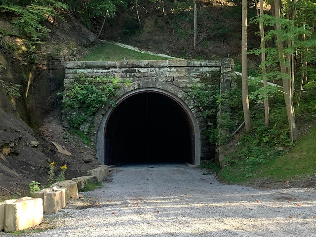
North Portal of Brady Tunnel
Uploaded: 1/12/2015
Collapsed roof of tunnel inside tunnel portal
|
 |
Chris Ziegler commented on a post
Targeting June 1 as a start date for further restoration of the turntable. The southern sluice is being fabricated as I write this and an additional 74’ of steel liner will be added to the 52’ we completed last year. |
 |
| Chris Ziegler commented on a post |
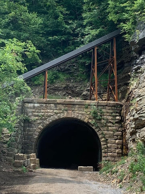
This photo shows the sluice over a portal to keep water off of the tunnel. The post-gazette says the sluice is at the northern end, but everything else, including the photo, indicates it is over the south portal.
The north end in the satellite view was in the shadows. So I fired up Google Earth to see if I could find a year with better lighting. This view shows why they need to restore the tunnel to complete a trail from Pittsburgh to Erie. It appears the old route that followed the river has been wiped out by landslides.
 |
| Google Earth, Sep 2017 |
This map confirms that there is a gap in the trail between the North Portal and the town of East Brady. I had to hunt for a while to find this map. I found a lot of information about the funding of the restoration work, but none of that information indicated where the tunnel was.
Two of the five photos
posted by Rich Tallis in Jan 2022:
 |
a
Southern portal of Brady Tunnel…being rehabilitated this summer. Water diversion sluice was rehabbed in 2020. |
 |
b
Northern portal Brady tunnel. Rehabilitated in 2019 for use on a bike trail. Currently not opened for through traffic. |


No comments:
Post a Comment