These are notes that I am writing to help me learn our industrial history. They are my best understanding, but that does not mean they are a correct understanding.
Wednesday, June 24, 2020
Amelia Earhart and Railroad Bridges over the Missouri River at Atchison, KS
This July 2013 image has all three bridges. The old US-59 bridge was blown up yet that year. The west side of the swing span is hidden by a couple of trees. The white control house is to the left of a tree. It is on the side of the span, which is a rather unusual position for a control house.
I think this is the first time I did not specify the owning railroad in the title. By looking at the 2005 SPV Map, I concluded that UP, because of the Missouri Pacific, owned this bridge because the Santa Fe route to Atchison has been abandoned. But Bridge Hunter has BNSF in its title. So I took a closer look at the SPV Map. It turns out that CB&Q had tracks on both sides of the river. On the west side the tracks went north of Atchison, and they are abandoned. On the east side they go north and south of this bridge, and they are still operated by BNSF. In fact, the tracks to the north are also used by UP to St. Joseph. If you search Bridge Hunter for Hurt, you can find four photos of a BNSF local using the bridge to service Atchison.
Postcard via Bridge Hunter
As would be expected for 1900, it is a pin connected truss.
John Marvig via Bridge Hunter
Steve Monroe posted four photos with the comment: "Old swing (span) bridge and I assume Operator station. Atchenson Kansas- Missouri River."
Fred Rick: UP still uses the bridge for headroom switching.
Frankie Byrd posted six photos with the comment: "N/B Amelia Earhart Bridge."
1
2
3
4
5
6
Fortunately, someone copied KDOT's construction photos into Bridge Hunter because KDOT's Flickr photos seem to have disappeared. I tried some searches on Flickr, but I got only people talking rather than any bridges. Unfortunately, the resolution on Bridge Hunter is too low for me to determine what kind of crane was used on the barge. They do show that the network tied arch span was built over the river rather than built along a shore and then floated into place.
KDOT via Bridge Hunter, License: Creative Commons Attribution-NoDerivs (CC BY-ND)
KDOT really sucks at maintaining their links. This was supposed to be about the new bridge. MoDOT is equally bad: AmeliaEarhartBridge. It is like someone purged all mention of this bridge: flooding impairs construction.
Aaron Hall Photo via Bridge Hunter, License: Creative Commons Attribution-Share-Alike (CC BY-SA)
The Earhart bridge is less than half as wide as the new bridge. Picture taken from the 5th street viaduct in Atchison.
[The old cantilever bridges were narrow, but they are certainly wide enough for a trail. But Coast Guard regulations require that bridges over navigable rivers not carrying trains or vehicles be removed. I assume that the traffic on the new bridge is light enough that dedicating a lane for emergency vehicles on the old bridge would not hold water.]
(new window) time lapse of the construction
It is interesting watching the river level going up and down.
Below is all of the Google Earth images available during the construction period. Note that the first three are just one month apart. Then they are two years apart.
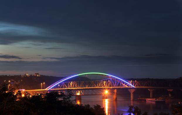
ISC-amelia "Located in Atchison, KS, The Amelia Earhart Memorial Bridge spans the Missouri River on U.S. Route 59 between Atchison, Kansas and Buchanan County, Missouri. The bridge was built to replacing the existing bridge, which was in use for 74 years and located only 78 feet north of the new bridge. The new tied-arch bridge is a four lane highway that spans approximately 2,546 feet. Using 625 tons of steel, this bridge was designed by HNTB with a 100-year design life and capable of handling 12,400 vehicles per day."
The bridge is now jointly owned by BNSF and UP but was once jointly owned by CB&Q and CRI&P. Each had a line coming from the east; CRI&P's was built in 1859 from St. Joseph, CB&Q's was originally the Kansas City St. Joseph and Council Bluffs main line, downgraded to a branch between Armour (a junction with a later CB&Q bypass main at 39.54734 -95.04463) and Winthrop Junction (39.56015 -95.10699) where it joined the CRI&P to cross the Atchison bridge.
On September 1, 1964, MP acquired trackage rights from CB&Q between Atchison and St. Joseph. Later, BN purchased CRI&P's route and eventually abandoned their own original route. UP inherited MP's trackage rights. I do not know why UP acquired the CRI&P's share of bridge ownership.
The CB&Q branch between Armour and Winthrop Junction has been abandoned for years (I show no abandonment date) being plowed under and flooded. BN's successor, BNSF, allowed the ex-CRI&P line to deteriorate and has now abandoned it from just east of Winthrop Junction to just southwest of Rushville where the connection to BNSF's St. Joseph Subdivision has been removed; the frequent Missouri River floodwaters (like those which have kept the surrounding farms drowned for the last two years) may have influenced that decision to abandon.
BNSF owns the first 150 feet of track west of the bridge, and all the track which remains east of the bridge, but there are no customers on the line. The wye at Atchison may still be in service, but there is no space past the east wye switch for an engine to turn without the swing bridge to be operated (39.56016 -95.1143). Perhaps you have a local or nearby contact who can update you on the status of the Atchison wye tracks.


Re: http://industrialscenery.blogspot.com/2020/06/amelia-earhart-and-railroad-bridges.html
ReplyDeleteThe bridge is now jointly owned by BNSF and UP but was once jointly owned by CB&Q and CRI&P. Each had a line coming from the east; CRI&P's was built in 1859 from St. Joseph, CB&Q's was originally the Kansas City St. Joseph and Council Bluffs main line, downgraded to a branch between Armour (a junction with a later CB&Q bypass main at 39.54734 -95.04463) and Winthrop Junction (39.56015 -95.10699) where it joined the CRI&P to cross the Atchison bridge.
On September 1, 1964, MP acquired trackage rights from CB&Q between Atchison and St. Joseph. Later, BN purchased CRI&P's route and eventually abandoned their own original route. UP inherited MP's trackage rights. I do not know why UP acquired the CRI&P's share of bridge ownership.
The CB&Q branch between Armour and Winthrop Junction has been abandoned for years (I show no abandonment date) being plowed under and flooded. BN's successor, BNSF, allowed the ex-CRI&P line to deteriorate and has now abandoned it from just east of Winthrop Junction to just southwest of Rushville where the connection to BNSF's St. Joseph Subdivision has been removed; the frequent Missouri River floodwaters (like those which have kept the surrounding farms drowned for the last two years) may have influenced that decision to abandon.
BNSF owns the first 150 feet of track west of the bridge, and all the track which remains east of the bridge, but there are no customers on the line. The wye at Atchison may still be in service, but there is no space past the east wye switch for an engine to turn without the swing bridge to be operated (39.56016 -95.1143). Perhaps you have a local or nearby contact who can update you on the status of the Atchison wye tracks.