A much needed straightening of Renwick Road was done. Fortunately, they turned this bridge into a pedestrian bridge.
 |
| 20200317 1655 |
I was surprised that Will County is down to just this one through truss bridge.
Date of Construction:
1912, accepted date, possibly earlier
Although the locally accepted date of construction of the bridge is 1912, the truss details incorporate practices common in the 1880s and 1890s. [An argument that this bridge was built before 1900 is that the company was absorbed by the American Bridge Company in 1900. "It is questionable that the company would have continued to use the Wrought Iron name plate after merger." An argument that it was built before 1890 is that it doesn't have knee bracing.]
Significance:
This single-span bridge, located near a historic site on DuPage River is a through Pratt truss, 151 feet in length, the last surviving through truss in Will County, and an example of a bridge type once familiar in Illinois. This truss, built by the Wrought Iron Bridge Company, is one of three spans in the state known to have been built by this prolific Canton, Ohio, builder. Pin-connected Pratts were a common late 19th and early 20th century metal truss design which is vanishing from the American landscape.
[HAER-data]
Comparing my photo at the top to the comparable HAER photo, I noticed that someone has stolen the plaque on top of the west portal since 1995.
 |
HAER ILL, 99-PLAIN. V, 1--33. VIEW TO SOUTHEAST - Renwick Road Bridge, Plainfield, Will County, IL |


This plaque became an example of the economics of a digital camera allowing one to take photos early and often. I took the following photo after I realized that it may be hard to read the text in the above photo because of the extreme angle. But the above photo ended up being more readable because of the lighting.

There has to be a story behind these bent bars.


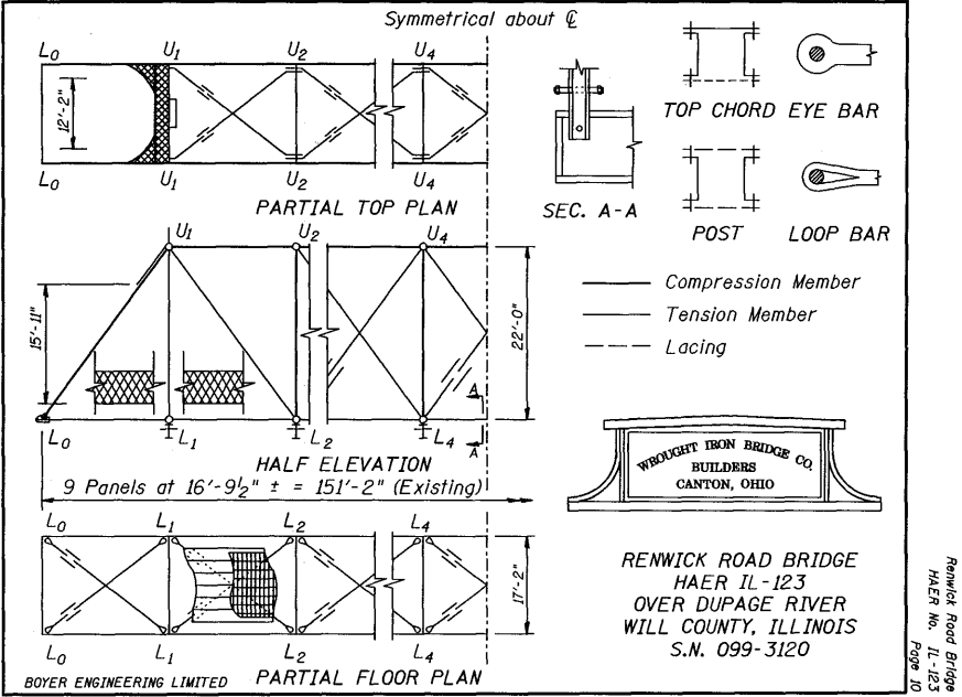
The above photo also shows how the end of the tension members have a loop instead of the usual eye. It also shows how some people will go out of their way to litter. Almost every joint an upright and its floor beam had at least one can in it. The following diagram provides the appropriate terminology for the tension members. The bottom chords, which are bigger, are eye-bars whereas the diagonal members, which are smaller, are loop bars.
 |
| HAER-data, p11 |

Since we are close to the dolostone quarries in Joliet and Lemont, it is no surprise that the bridge abutments are made with cut stone. These are the west and east abutments, respectively. The HAER report indicates the stones are 3' deep.


The HAER report observes that there is no knee bracing. I think knee bracing is reinforcement of the joints between the upright members and the floor beams to hold them at 90 degrees during a wind load. In fact, as the report indicates, the joints in this bridge are just pin connected. That is, they have no resistance to bending under a wind load. HAER indicates that knee bracing was introduced around 1890. In the following photo, I was trying to catch how the size of the bottom cords are smaller in the panels that are closer to the abutments. But it also catches how the upright member is connected to the top of a floor beam with just one pin.

This photo shows that some repairs have been made.

It was obvious that this was a rare old bridge, so I took a lot of photos while I was there. The following is a dump of the remaining photos that I took.


Looking upstream we see the replacement bridge.


When the HAER record was written in 1995, the plan was to move this bridge for preservation and build a new bridge at this location. Fortunately, for the greater good, homes were purchased so that the new bridge could be in a location that allowed Renwick Road to run straight over the river. Not only did they have to purchase the homes that were in the way of the new alignment, they had to purchase the homes between the CN/EJ&E tracks and the river because they became isolated when the old bridge was closed to vehicular traffic. I captured the Global Earth images before, during and after construction.
 |
| Global Earth, Sep 2011 |
 |
| Global Earth, Mar 2012 |
 |
| Global Earth, Apr 2013 |
No comments:
Post a Comment