This lock is on the Gulf Intracoastal Waterway.
Lock dimensions: 780' (238m) x 74' (22.5m) [USACE_LockStatus]
 |
| Don Pirolo Flickr, License: Creative Commons Attribution-NonCommercial (CC BY-NC) Intracoastal Waterway at Algiers Lock A little bit of everything. The intracoastal waterway with miscellaneous cargos, the Algiers lock, the Mississippi River, the Valero Meraux refinery and an Algiers neighborhood. It sure looks like the water level in the intracoastal is higher than that neighborhood. |
 |
| Mar 19, 2024: USACE, New Orleans District posted The first tow locking through Algiers Lock upon the completion of the 58 day emergency dewatering in late 2023. Last year's lock dewatering came in under budget and schedule to restore navigation on the Gulf Intercoastal Water Way (GIWW) for shallow draft navigation. Algiers Lock is located on the west bank of the Mississippi River at mile 88 above Head of Passes. Photo by – David Smith [It is disturbing that the USACE would spell it Intercoastal instead of Intracoastal. It is one thing for a general publication to spell it incorrectly, it is another for the USACE to make that mistake. This is also the first time I've seen waterway spelled as two words.] Brandon Hayes: So is the long wall now fixed or is it still completely unusable? US Army Corps of Engineers, New Orleans District: Brandon Hayes The long wall is still off limits to vessels for berthing. A contract is being awarded to replace the former dolphin and damaged guidewall. Gary Davis: Brandon Hayes bingo you guessed it. Not fixed. |
The rest of the story:
 |
| Jul 7, 2024: WaterwaysJournal_allision, Photos courtesy of New Orleans Engineer District "About 6 p.m. on July 4, a towing vessel pushing a loaded barge entered Algiers Lock in New Orleans from the Mississippi River, bound for the Gulf Intracoastal Waterway (GIWW), when it allided with the lock’s canal-end sector gates....According to Landry, the towboat captain reported to the Algiers lockmaster that a surge of water from the wake of a passing ship pushed the tow into the gate." They could afford to push the closure back until mid-September, and the closure would last 45 to 60 days. One reason to delay the closure is to allow planning and preparation for the repairs. Another is that the Harvey Lock was closed due to low levels on the Mississippi River. Since this lock would have to close if the river level rises and gets close to the 10' gash in the gate, the Harvey Lock should be able to open before this lock closes. But the Harvey Lock is smaller than the Algiers Lock. A third reason is to try to remain open as long as possible during the hurricane season to support evacuation of the area. |
Sep 15, 2023: They plan to close Oct 2 for a 60-day closure even though it looks like Harvey will have to remain closed. Tows can use longer routes through the Old River Lock or Port Allen Lock. [WaterwaysJournal_closure, LouisianaMaritime]
I have not been able to determine what happened between the planned opening on Dec 1, 2023, and the "first tow" on Mar 19, 2024. The Facebook posting said the dewatering was under budget and on schedule. So why were tows delayed for 5.5 months instead of just 2 months?
This lock also suffered a four-month closure in 2013. It is one of eight locks on the gulf Intracoastal Waterway, and it "typically has more than 2,800 barges, tows and vessels pass through it each month." [nola]
Apr 2024:
 |
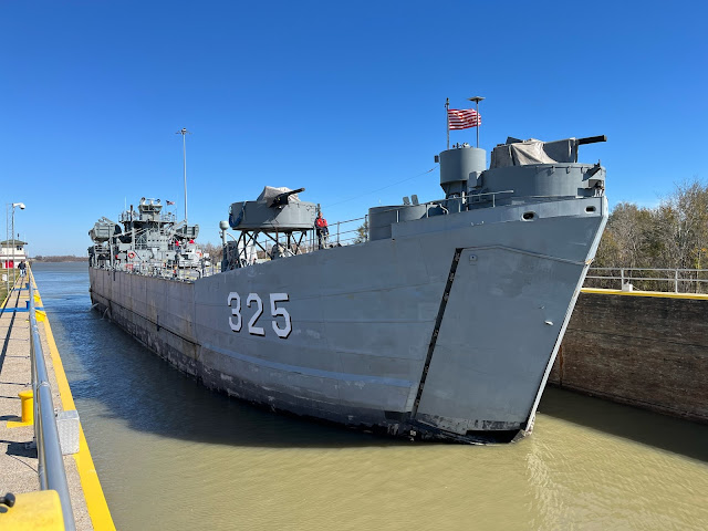
| USACE, New Orleans District posted The last fully operational World War II Landing Ship Tank (LST) USS LST-325, currently a museum/memorial ship that docks in Evansville, Ind., passes through the Algiers Lock en route to a shipyard in Texas for repairs. The Algiers Lock, which was built by the U.S. Army Corps of Engineers in 1956, is located just below New Orleans, La., on the west bank of the Mississippi River at mile 88 above Head of Passes. This lock provides an alternate waterway connection from the Mississippi River to the Gulf Intracoastal Waterway (GIWW) at mile 6 west of the Harvey Lock. (Courtesy photo by Robert Swayze) |
This video is boring until 2:22 when the tow starts moving right along.
 |
| 3:02 video @ 2:22 |

No comments:
Post a Comment