(
Satellite)
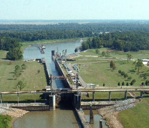
This lock is on a branch of the
Gulf Intracoastal Waterway.
Jess Raen
posted two photos with the comment: "The Jessica Brent heading through Old River Lock this morning."
[It is approaching the Mississippi River or east side. Note that Jessica Brent has a retractable pilothouse.]
Dennis DeBruler: I read that the lock was supposed to close May 13, 2021, because of high water. I wonder when it opened again. [
nola, USACE closes the lock at 62.5' to remove electrical equipment and to start sandbagging.]
Jess Raen: Dennis DeBruler not sure but i can tell you we went through it yesterday [June 2, 2021] and the day before.
 |
| 1 |
 |
| 2 |
The tall structure to the right of the crane in the above photos is a lift bridge. This street view was taken from that bridge.
The Mississippi doesn't seem to be that much higher than the Atchafalaya River in this photo. To maintain a ratio of flow to the Mississippi and Atchafalaya Rivers, a lift of 4' to 19' is maintained. [
OldRiverControlBrochure, p6]
For a nice description of this evolution of the rivers, search for "parallel courses" in
landingaday. That description includes how to pronounce the new river created in the 15th Century: "ah chaf fa LIE ya"
When they built the lock, they also dammed the Lower Old River.
I have not figured out how barge traffic is split between this Atchafalaya waterway and the
Port Allen Lock Waterway. Does the bulk of the traffic on the Gulf Intercoastal Waterway consist of petrochemicals headed to the Baton Rouge part of the Mississippi and the Atchafalaya handles the 15 tows a day that is going further up the river? I scanned both waterways with a satellite map. The only tow I saw on the Atchafalaya waterway was actually on the Red River. I saw about a dozen on the Port Allen Lock Waterway if I include those that can
lock through to the Little Tensas Bayou.
U.S. Army Corps of Engineers, Rock Island District
posted three photos with the comment: "Recently, the Rock Island District's
Quad Cities heavy-lift crane and it's crew we working down in the
US Army Corps of Engineers, New Orleans District to replace two miter gates at the Old River Lock. The new gates were stored in a horizontal position, so the crew had to stand the gates up to install them and lay the old gates down to be stored. While this sounds like a pretty simple task, nothing is simple when you are dealing with miter gates of that magnitude."
Kent Holmgrain: How many tons per gate section?
Cary Hahn: Kent Holmgrain 204
 |
Layne Logue commented on USACE's post
Old River Lock is supposed to be opened on Nov. 20. |
Fort Loudoun Lock
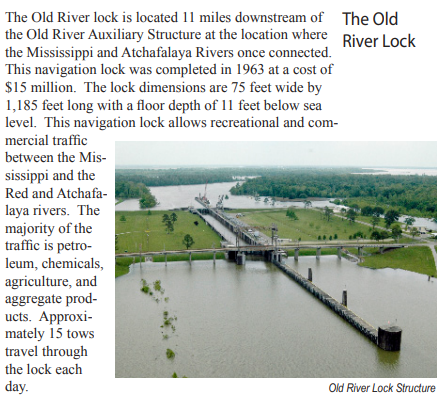
posted two photos with the comment: "Some pics from the recently dewatered 'Old River Lock"'operated & maintained by the New Orleans District Corps of Engineers near Lettsworth, LA. The Old River Lock is located 11 river miles downstream of the Old River Auxiliary Structure at the location where the Mississippi & Atchafalaya Rivers were once connected. Amazingly, this lock was completed in 1963 at a cost of just $15M! The concrete finished lock chamber floor makes it safe & convenient for equipment to be operated as can be seen in these pics. Not every lock has a finished flat surface like this one for ease of operations during major maintenance."
John Conway: Does Ft Loudoun lock have a concrete floor or is it just old river bottom?
Fort Loudoun Lock: John Conway We're lucky on the TN River. The natural bedrock at most locks serves as a sufficient surface for a lock chamber floor without having to pour concrete. Additionally, Watts Bar & Fort Loudoun both are fairly clean on the bottom when we pump them out. There isn't a lot of mud, silt, or other debris built up such as is seen on the Mississippi, Ohio, and Illinois River lock chamber floors.
 |
| 1 |
 |
| 2 |


No comments:
Post a Comment