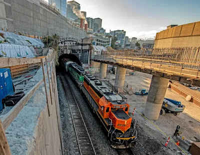
South Portal: (Satellite)
South Portal:
 |
| Street View, Aug 2015 |
 |
| Steven J. Brown posted Burlington Northern wide-vision caboose 10107 (built as CB&Q 13689) on the Maltby Turn returning to Interbay at South Portal in Seattle, Washington - May 1990. Billy Irwin: This caboose is still [2025] in service today with a updated paint job in the Seattle Stacy switch yard Steven J. Brown shared |
 |
| Bob Squaredancer commented on Steven's post Cool now I know the name for this location. South Portal, 1979. 📷credit Greg Taggart |
North Portal: You can't see the portal with a street view because the road is too high.
 |
| MyNorthwest "It’s still serving freight customers and passengers, with 2,500 people and the equivalent of 12,000 truckloads of goods and other materials moving through the 113-year old subterranean corridor every day [in 2018]." |
The north portal before the viaduct was built.
 |
| MyNorthwest |
I presume the retaining walls were built to help create some more land area for the city.
 |
| Photo via pauldorpat, 2020 The tunnel allowed the Alaskan Way to be built where there used to be eight tracks. The 5,141.5' (0.91 mile or 1,467.1m) long tunnel delivered trains to King Street Station and points south. "When completed, it was the highest (25.8 feet [7.9m]) and widest (30 feet [9.1m]) tunnel in the world. The tube was lined with 3-1/2 to 4-1/2 feet of concrete, reaching its deepest point 111 feet below Fourth and Spring. Curiously, it also delved through remains of an anaerobically preserved primeval forest at Fourth and Marion. (Soon after exposure to air, the trees reportedly turned to mulch.)" |
The Alaskan Way was built on the land that these tracks occupied.
 |
| HistoryLink "It cost $1,500,000 to build and was intended for use by both the Great Northern and the Northern Pacific Railroads, which split construction costs." The tunnel went north from the south portal on the west side of 4th Avenue to at least Spring Street. |
I've looked at several topo maps, but none of them have dashed lines showing the route of the tunnel.
This shows why the material removed from the tunnel was used to create landfill for Kings Station and the railyards south of the station.
 |
| 1894/1908 Seattle Quad @ 62,500 |
And that filled just part of the swamp.
 |
| 1908/55 Seattle Quad @ 62,500 |
The route to the original tracks along the waterfront explains the shape of these buildings.
 |
| Satellite |
No comments:
Post a Comment