Detailed maps (I haven't found an index for these maps. The Scioto County files are numbered from north to south, but listed south to north..)
The lock size was 15' (4.6m) x 90' (27.4m). [case]
 |
| NPS history of the O&E "Using design specifications from the Erie Canal, construction on the Ohio & Erie Canal began throughout the state in 1825. It took two years of hand digging to complete the section from Cleveland to Akron, and five more years to finish all the sections. Dug largely by Irish and German immigrants, this four-foot-deep ditch stretched 308 miles to Portsmouth on the Ohio River. By the fall of 1832, the canal promised passage from Cleveland to Cincinnati in 80 hours, a trip that had once taken weeks." |
"Construction of the Ohio & Erie Canal (called the “Ohio Canal” for short), began in 1825, and was completed from Lake Erie at Cleveland to Portsmouth on the Ohio River by 1832. The Ohio & Erie was the first, the longest (309 miles), and the busiest of a network of waterways that would become 813 miles of canals in Ohio." [uakron]

Locations for which I have notes:
Northern part from Akron to Lake Erie:
- Locks 2-4
- Locks 5-9
- Locks 10-16, the Cascade Locks
- Cascade Race and Mills
- CVSR/B&O and W&LE/AC&Y Bridges over O&E Canal
- Cascade Mills
- Locks 37, Aqueduct and 38
Southern part from Akron to Ohio River:
- Conesville, OH
- Lock 22
- Locks 29 & 30
- Chillicothe: in 1877 boatloads of iron were delivered to build the N&W/Scioto Valley Railroad Bridge.
- Covered Bridge over O&E Canal near Waverly, OH
- Locks 48 & 49 near Rushtown, OH
 |
| Ron bishop posted Imagine the difference should these waterways be navigable and in use today. [I don't normally include an "at" clause, but in this case it is very important: " is at Safe Harbor Aqua Yacht." My reaction when I first saw this post was that only recreational boats could use it. But when I noticed where he was at, I realized that is exactly what he would want.] |
 |
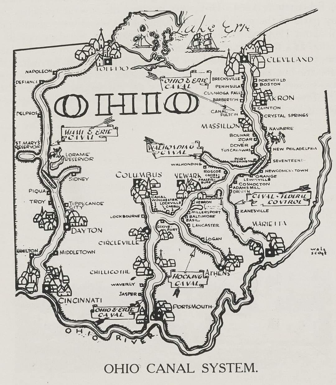
| Bobbie Flinders Wilson posted Prior to Railroads and Interstate Highways... The "Ohio Canal System", built between 1825 and 1845 at a cost of more than $8 million (equal to $275 million today), included the following two primary canals, plus five feeder canals: Two Primary Canals: 1) the "Miami & Erie Canal"--from Lake Erie at Toledo to the Ohio River at Cincinnati; 2) the "Ohio & Erie Canal"--from Lake Erie at the mouth of the Wabash River at Cleveland to the Ohio River near Portsmouth, Five Feeder Canals: 1) the "Pennsylvania & Ohio Canal"; 2) the "Sandy & Beaver Canal"; 3) the "Hocking Canal"; 4) the "Wabash & Erie Canal"; and 5) the "Cincinnati & Whitewater Canal", plus several smaller short feeders. The following map shows the routes of the entire "Ohio Canal System", plus the location of several "Canal Reservoirs" throughout the state Lew Carbone: This map ignores the Milan Canal, in North-Central Ohio. This was a deep-water canal that could accommodate lake-going ships. Along with the Erie Canal, it allowed Northern Ohio farmers to connect to markets in New York City. Amanda Phillips posted with a copy of the above description |
Carl Byron posted via Dennis DeBruler:
Wow! Someone asked about the story behind the locks in Akron, OH; Thank you! I never expected more than a passing interest in them. But the story is long, even in my abbreviated version, so here goes. I hope you enjoy:Akron’s name comes from a Greek word meaning elevation, high point or peak. Akron and its bigger region, Summit County, were both named because they were the highest points on the Ohio and Erie Canal when the canal was operational, directly following the watershed path between Lake Erie to the north and the Ohio River to the south.The stretch of canal began in the early-mid 1820s and was completed in 1827. At the time the region and Ohio were growing rapidly and industries moved into Ohio and needed a means of moving people, crops and food, workers and goods. A set of 24 locks comprised the works completed in 1827 and became a significant thoroughfare in the Ohio Erie Canal Circuit. The 24 locks leading to Cleveland were in a stairstep pattern, leading to them being commonly called “The Cascade”. Some writers have stated locks 1, 2, and 3 were the most famous: I would amend that somewhat and simply say they were the most commonly known. As a kid in the 1960s even I was familiar with them.The initial decades after the locks were in place were an enormous boon to industry and The Ohio and Erie Canal System stood as one of the greatest engineering feats in the country. Several industries and companies made their home in Akron right along the lock route: in particular perhaps the last industry giant to use the canal for its original purpose. A German immigrant and mill worker, Ferdinand Schumacher began mass producing oatmeal in Akron in 1856 (his company would later merge with several others and become Quaker Oats, also headquartered in Akron). Demand for oats skyrocketed during the Civil War as a cheap and convenient alternative to meat or other high-calorie foods, and the canal and hub of railroads in Akron allowed for easy milling and shipping.In 1863 Lock 3 was opened for private businesses to use, and I do know a lumber yard used it. I believe the 3 locks were also allowed to be sold: I can't remember if the lumber company actually bought Lock 3.But in the paragraph above I mentioned another mode of transport, which would be the death knell for the Cascade: the locomotive. As technology improved it was clear railroads had far fewer limitations to travel, and their range was far greater. But, as events would unfold the locks weren’t dead: just morphed.When Goodyear (and Goodrich) started gaining steam in Akron Goodyear learned the process of vulcanizing rubber; a chemical binding process that strengthens rubber by heating it with sulfur and other additives. The process creates a chemical reaction that bonds the rubber molecules, making the rubber more durable, flexible, and adaptable. At first neither company did well but after vulcanization and the World Wars Goodyear became synonymous with Akron. And how did the locks fit? The water and engineered pathways were necessary for the vulcanization process.The history of The Erie and Ohio is fascinating, and these bits of information are what I remember clearly-but there is so much more. It is really worth the time to study it. The locks drew in many Irish immigrants to build and work them: the first mass production company in the US started along the locks route, making clay marbles for children’s games. Companies also found a workable, strong clay in the area and as well as the toy marbles made sewer pipes and tiles, many of which were used in the New York City subways.Akron is the Rubber City alright, but its history to me always seems unusual for the region. Locks 1, 2, and 3 still exist in one form or another and several organizations are trying to save them permanently. One, I think Lock 2, was turned into a canal-side restaurant about 6-7 years ago.
 |
| uakron "The 1913 flood ended the life of the Cascade Locks and of the Ohio & Erie Canal." |
I quit watching soon after the singing continued after the narration resumed.
 |
| 26:48 video |
 |
| 10:56 video How the Ohio & Erie Canal Changed America Forever The Erie Canal inspired everyone to build their own canals. Ohio responded with the Ohio & Erie Canal, spanning Ohio from Cleveland hundreds of miles south to the Ohio River. The canal opened up Ohio to easy travel and expanded commerce. |
Muskingum River Waterway
A waterway between the Ohio & Erie Canal and the Ohio River was created by building locks and dams from 1836 to 1841 on the Muskingum River. This allowed steamboats to go upriver all the way to Zanesville, OH. The locks were 35'x160'. [hmdb] The waterway had 10 dams and 11 locks. 10 of the locks are still operational. "It is the only remaining system of hand-operated locks in the nation." [OhioDNR]
Most sources specified the lock dimensions as 35'x160'. But ASCE specifies 36'x184', which allows boats up to 160' long to use the canal. It was one of the first complete slackwater navigation systems for steam-powered vessels in the USA.
- #11 at Ellis is no longer operational (Ellis seems to have become a ghost town.)
- #10 in Zanesville, a double lock: 7 photos, 1 photo
- #9 in Philo: 3:22 video of "history in your own backyard"
- #8:
- #7 in McConnelsville: 3:46 video demonstrating the operation of the lock
- #6 at Stockport: Facebook Reel
- #5:
- #4 at Beverly: 1:51 video about the reopening
- #3 at Lowell: 7 phptos and some river system history
- #2 near Devola: 3 photos, 1 of which has the Valley Gem stern wheeler
- #1 was removed after the Belleville Dam raised the Ohio River level. Original lock wall Replacement (larger) double-lock wall

 |
| NewsAndSentinel The double lock and the dam in Marietta was removed in the 1960s after the Ohio River was raised by the construction of the large lock and dam in Belleville. |
It took five years after the flood of 1913 to repair the system. The USACE quit supporting the waterway in 1948. The state took back ownership in 1958 and restored the system for recreational use, [OhioHistoryCentral]
 |
| Mike Tewkesbury posted Southeastern Ohio's Muskingum River and its navigation system of ten hand-operated locks date back to 1837 when local settlers recognized the potential of the river to be used as a shipping route for steam powered vessels. It is one of the earliest navigational systems built for steamboats in the United States. Once these locks and dams were in place, commercial shipping flourished for nearly 70 years, but was ultimately replaced by rail and motorized transportation shortly after the turn of the century. Today the system is used mainly by pleasurecraft and fishing vessels between Zanesville and Marietta stretching over a distance of 90 miles. Pictured is Lock and Dam Number 2, known as Devols Dam, just north of Marietta. Ron Bishop shared |
 |
| Facebook Reel |
 |
| Harmar Village - Marietta, Ohio .....the MUSKINGUM RIVER is formed in Coshocton where the Walhonding and Tuscarawas Rivers merge. After traveling approximately 112 miles the Muskingum River reaches Marietta where it meets the Ohio River. A series of locks, dams, and short canals—most of them built between 1836 and 1841—control flooding and make the river navigable. The name is of Algonquian origin and probably means “by the river.” The Muskingum ends its journey when it merges with the Ohio River in Marietta, Ohio. The Muskingum River is the longest river in that is has both of its banks within Ohio. In the past, before the widespread use of railroads and to a greater extent the interstate system were built, this body of water was used greatly for transporting goods down and upstream to other communities for purchase. ********** The Muskingum River Parkway State Park is on the National Register of Historic Places and is recognized as the Muskingum River Navigation Historic District. In its day, the system of locks and dams helped open the state and the entire Midwest to trade and development. It is one of only two remaining systems of hand-operated locks in the nation. The locks help boats safely bypass ten dams on the Muskingum River from Zanesville south to the Ohio River at Marietta. These locks are operated at no charge for recreational boats. Ten of the eleven locks still function— the northernmost lock, Ellis #11, is no longer in operation but offers a campground. The remaining locks have a variety of amenities and many communities along the Muskingum River offer recreational and sight-seeing opportunities for boaters and non-boaters alike. Visitors may enjoy watching the river from the park's picnic shelter south of Lock #7 on State Route 376. Sources: * Britannica * ODNR Andrea Ralston: The Muskingum River was made navigable starting in the 1820s as part of the Ohio & Erie Canal - https://storymaps.arcgis.com/stories/dce2f1f0f0fd4c8e86d4bdae6448c3a8 Read “Taming the Muskingum” by Emory L. Kemp for an engineering & construction perspective. |
No comments:
Post a Comment