South Norfolk Jordan: (Satellite)
1907 NS/VGN, swing: (Bridge Hunter)
NS/VGN, lift: (Bridge Hunter; 3D Satellite)
1938+1958 Gilmerton, trunnion: (Bridge Hunter)
2014 Gilmerton, lift: (Bridge Hunter; 3D Satellite)
NS/NW, rolling: (Bridge Hunter; 3D Satellite)
former Great Bridge, swing: (Bridge Hunter)
2004 Great Bridge, rolling: (Bridge Hunter; 3D Satellite)
1969 I-64+US-17 High Rise Bridge, trunnion: (Bridge Hunter; 3D Satellite)
NPB = Norfolk and Portsmouth Belt Line,
owned by NS+CSX/ACL+NSRY+NW+Pennsy+SAL+VGN
The NPB bridge actually goes between Portsmouth and Chesapeake, which are towns south of Norfolk. The other bridges are in Chesapeake. I used Norfolk in the title because I did not know about these other two towns until I came across the photo below. I discovered that Norfolk Naval Shipyard is actually in Portsmouth, not Norfolk.
Two photos posted by Bridges & Tunnels.
There are no bridges downstream from this bridge, just tunnels. Note that there is an aircraft carrier in the drydock at the naval shipyard.
This is the post that motivated me verifying that there are no bridges downstream from the naval yard.
This is one of five photos in a VDOT Album that shows the bridge operating. It shows the approach lanes being built for the new bridge on the right. Note the cranes over by the bridge tower. The following photo was taken from that side and gives us a better view of the cranes that are doing the foundation work.
You have a choice for looking at VDOT's 112 photos on Flickr or Bridge Hunter.
(new window) I can't believe that VDOT monetized this video.
(new window) There is no useful information after 1:57.
(new window) A sign at 1:06 indicates the bridge was closed Jan 7-20. So the replacement of the movable span within a day was really just a small fraction of the time that the bridge was closed to vehicle traffic. But I assume marine traffic was stopped for just that day. This video has too much "talking head" time for me to recommend. One factoid I did learn was that the offsite construction area was seven nautical miles upstream from the bridge and it took just 2 hours to float the span down the river because the lifts of the other bridges over the river had been carefully scheduled. If you want a drinking party, take a drink every time they talk about the collaboration/communication between blaa, blaa, and blaa. This video said the tolerances between the span and the tower was a few inches. The above video said a half-inch. That is an important enough fact that I would expect agreement if there was such good communication on this project. I quit watching at 5:53.
This video settles down to a professional narration over interesting construction scenes. It adds the information that the four lanes can be expanded to six. The span is wide enough that eight 120,000 pound sheaves are used. There is some foundation info at 4:43. They talk about the big oscillator that was used to drill the eight 12' piles 80' below the river bed. The steel towers are 207' tall and provide 135' of vertical clearance. The lift span is 89'x250' and weighs 5,000,000 pounds. Video showing the span float starts at 7:19. It was done on Jan 7, 2013. Useful information ends at 9:07 unless you are playing the suggested drinking game and looking for shots like the one below. It shows the two towboats on the span barge and the crane barge that followed behind.
It looks like rail traffic is low enough that the bridge is normally kept in the open position.
Before they shoved the new span into place, they had to move the towboat out of the way to lower the railroad bridge for a train. After the train passed, they shoved the span into place.
I could not find a photo of this bridge. Since it was replaced in the 21st Century, I fired up Global Earth to find an image of it. It doesn't look like a swing bridge from above because it is a deck plate girder swing bridge.
I included all of the images after 200204 until the construction was done.
I included the next two images because they capture the bridge in an open position and show that a couple of boats passed through the bridge.
A 4-lane Scherzer rolling bridge was built in 2004 to replace a 2-lane swing bridge.
(bridge going up and down)
I save a satellite image because they are doing some construction. Unfortunately, I don't have time to research what they are working on.
1907 NS/VGN, swing: (Bridge Hunter)
NS/VGN, lift: (Bridge Hunter; 3D Satellite)
1938+1958 Gilmerton, trunnion: (Bridge Hunter)
2014 Gilmerton, lift: (Bridge Hunter; 3D Satellite)
NS/NW, rolling: (Bridge Hunter; 3D Satellite)
former Great Bridge, swing: (Bridge Hunter)
2004 Great Bridge, rolling: (Bridge Hunter; 3D Satellite)
1969 I-64+US-17 High Rise Bridge, trunnion: (Bridge Hunter; 3D Satellite)
NPB = Norfolk and Portsmouth Belt Line,
owned by NS+CSX/ACL+NSRY+NW+Pennsy+SAL+VGN
The bridges on the East Branch of the Elizabeth River are in another post.
The NPB bridge actually goes between Portsmouth and Chesapeake, which are towns south of Norfolk. The other bridges are in Chesapeake. I used Norfolk in the title because I did not know about these other two towns until I came across the photo below. I discovered that Norfolk Naval Shipyard is actually in Portsmouth, not Norfolk.
NPB
 |
| Norfolk Southern posted
Norfolk Southern partners with 263 short line railroads. The NS Short Line Marketing Group works with short line partners to serve the transportation needs of mutual customers. To learn more: http://bit.ly/32lakIO
Pictured: Norfolk & Portsmouth Belt Line Railroad GP38-2 #5260 crosses the Elizabeth River drawbridge from #Chesapeake into #Portsmouth as it moves back into the NPBL yard.
[According to Bridge Hunter, the lift span is 385'.] |
 |
| VDOT Flickr via Bridge Hunter, License: Creative Commons Attribution-NonCommercial-NoDerivs (CC BY-NC-ND) New Gilmerton Bridge span floats under the NS Railroad Bridge. (Photo by D. Allen Covey, VDOT) |
Two photos posted by Bridges & Tunnels.
 |
| 1 |
 |
| 2 |
There are no bridges downstream from this bridge, just tunnels. Note that there is an aircraft carrier in the drydock at the naval shipyard.
 |
| Satellite |
This is the post that motivated me verifying that there are no bridges downstream from the naval yard.
 |
| Navy General Board posted The Nimitz class aircraft carrier USS Harry S. Truman (CVN-75) making her way down the Elizabeth River after departing the Norfolk Naval Shipyard. For a ship the size of a supercarrier, navigating the river is no small feat. A cloud of silt can be seen behind the carrier, stirred up by her massive screws. Tugs maintain close formation around the carrier, ready to step in if needed. After navigating the river, the carrier will return to her base at Naval Station Norfolk at Hampton Roads. At the top of the photo, the stern and upperworks of the Iowa class battleship USS Wisconsin (BB-64) can be seen. [A comment indicates the photo was taken in 2004.] |
 |
| Patrick Lynch posted Crossing the Elizabeth River on this dramatic draw bridge, grain train G955 is arriving at Berkley Yard in Norfolk. This grain train is about to have a Norfolk Portsmouth Belt Line crew relieve the CSX crew which came from Richmond. The power on this train is two recently reactivated CW40-8s, 7771 and 7777. 3/19/23 |
South Norfolk Jordan Bridge
Three photos posted by Bridges & Tunnels.
 |
| 1 [At least they tried to protect the main piers.] |
 |
| 2 |
 |
| 3 |
NS/VGN Swing Bridge
 |
| Public Domain via Bridge Hunter |
NS/VGN Lift Bridge
 |
| 3D Satellite |
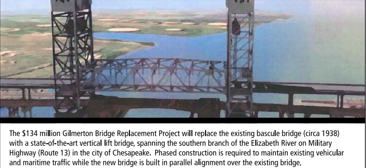
1938+1958 Gilmerton Trunnion Bridge
 |
| VDOT Flickr via Bridge Hunter, License: Creative Commons Attribution-NonCommercial-NoDerivs (CC BY-NC-ND) 15 foot clearence of the Gilmerton Bridge in Chesapeake, VA requires frequent traffic interruptions to allow water craft to pass through. Photo by D. Allen Covey, VDOT [The clearance of the replacement bridge is 35' and should require significantly fewer lifts. I remember the number 40%. But I can't remember if that was 40% fewer lifts. That is the price I pay for researching so many bridges in one day.] |
 |
| VDOT Flickr via Bridge Hunter, License: Creative Commons Attribution-NonCommercial-NoDerivs (CC BY-NC-ND) |
 |
| Digitally zoomed in on the above photo I believe the crane handling the foundation drill is a Manitowoc 2250. |
2014 Gilmerton
 |
| 3D Satellite |
 |
| VDOT |
 |
| VDOT |
 |
| VDOT |
 |
| VDOT |
(new window) I can't believe that VDOT monetized this video.
(new window) There is no useful information after 1:57.
(new window) A sign at 1:06 indicates the bridge was closed Jan 7-20. So the replacement of the movable span within a day was really just a small fraction of the time that the bridge was closed to vehicle traffic. But I assume marine traffic was stopped for just that day. This video has too much "talking head" time for me to recommend. One factoid I did learn was that the offsite construction area was seven nautical miles upstream from the bridge and it took just 2 hours to float the span down the river because the lifts of the other bridges over the river had been carefully scheduled. If you want a drinking party, take a drink every time they talk about the collaboration/communication between blaa, blaa, and blaa. This video said the tolerances between the span and the tower was a few inches. The above video said a half-inch. That is an important enough fact that I would expect agreement if there was such good communication on this project. I quit watching at 5:53.
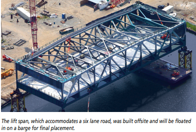
This video settles down to a professional narration over interesting construction scenes. It adds the information that the four lanes can be expanded to six. The span is wide enough that eight 120,000 pound sheaves are used. There is some foundation info at 4:43. They talk about the big oscillator that was used to drill the eight 12' piles 80' below the river bed. The steel towers are 207' tall and provide 135' of vertical clearance. The lift span is 89'x250' and weighs 5,000,000 pounds. Video showing the span float starts at 7:19. It was done on Jan 7, 2013. Useful information ends at 9:07 unless you are playing the suggested drinking game and looking for shots like the one below. It shows the two towboats on the span barge and the crane barge that followed behind.
 |
| 10:40 |
NS/N&W 1908 Scherzer Rolling Bridge
It looks like rail traffic is low enough that the bridge is normally kept in the open position.
 |
| 3D Satellite |
 |
| VDOT Flickr via Bridge Hunter, License: Creative Commons Attribution-NonCommercial-NoDerivs (CC BY-NC-ND) |
 |
| VDOT Flickr via Bridge Hunter, License: Creative Commons Attribution-NonCommercial-NoDerivs (CC BY-NC-ND) |
 |
| VDOT Flickr via Bridge Hunter, License: Creative Commons Attribution-NonCommercial-NoDerivs (CC BY-NC-ND) |
 |
| VDOT Flickr via Bridge Hunter, License: Creative Commons Attribution-NonCommercial-NoDerivs (CC BY-NC-ND) |
 |
| VDOT Flickr via Bridge Hunter, License: Creative Commons Attribution-NonCommercial-NoDerivs (CC BY-NC-ND) |
 |
| VDOT Flickr via Bridge Hunter, License: Creative Commons Attribution-NonCommercial-NoDerivs (CC BY-NC-ND) |
 |
| VDOT Flickr via Bridge Hunter, License: Creative Commons Attribution-NonCommercial-NoDerivs (CC BY-NC-ND) |
 |
| VDOT Flickr via Bridge Hunter, License: Creative Commons Attribution-NonCommercial-NoDerivs (CC BY-NC-ND) |
 |
| VDOT Flickr via Bridge Hunter, License: Creative Commons Attribution-NonCommercial-NoDerivs (CC BY-NC-ND) |
 |
| Jim Morris posted Chesapeake Virginia, that's one way to stop rail gang. [A comment has a 16 second video of the boat going through for which they were held up for an hour here. Since it passed under the bridge in less than 10 seconds, why did the tender think it needed to be up for an hour? Did something break?] |
 |
| Mark Hinsdale posted "Bridge 7" Very early in the Norfolk Southern era, a westbound train of empty coal hoppers roars across Bridge 7 spanning the South Branch of the Elizabeth River in the Norfolk suburb of Chesapeake VA. The N&W main line makes a sweeping hook turn in Norfolk, with westbound trains actually facing east as they leave the Lamberts Point terminal, then turning south through the inner east side of the city, before curving mostly west in the vicinity of Portlock to cross the vast Dismal Swamp and then head on across Virginia toward Petersburg and Roanoke. The Norfolk & Portsmouth Belt Line Railroad (NPBL) also serves this immediate area, making it one of the busier places to catch the rail action in Tidewater Virginia. January, 1984 photo by Mark Hinsdale Mark Hinsdale shared |
 |
| Dennis DeBruler commented on Mark's share The surroundings have changed a lot since 1984. https://goo.gl/maps/ch74vBE2pcEn3G766 |
Former Great Bridge Bridge, Swing
I could not find a photo of this bridge. Since it was replaced in the 21st Century, I fired up Global Earth to find an image of it. It doesn't look like a swing bridge from above because it is a deck plate girder swing bridge.
 |
| 200204 |
 |
| 200303 |
 |
| 200309 |
 |
| 200401 |
 |
| 200406 |
 |
| 200506 |
 |
| 200510 |
2004 Great Bridge Bridge, Scherzer Rolling
A 4-lane Scherzer rolling bridge was built in 2004 to replace a 2-lane swing bridge.
According to the Great Bridge Battlefield & Waterways History Foundation,"Opens on demand, except from 6 a.m. - 7 p.m. when it is opened on the hour." [CityOfChesapeake]
the Battle of Great Bridge was the first decisive land victory in the Revolutionary War.
For eleven days in December 1775,
cannons fired and smoke clouded the sky as British and American troops battled to the death.
It's hard to imagine this peaceful place was once the site of such bellicosity.
[VirginiaShire]
(bridge going up and down)
I-64+US-17 High Rise Bridge
I save a satellite image because they are doing some construction. Unfortunately, I don't have time to research what they are working on.
 |
| Satellite |
 |
| VaDOT Flickr via Bridge Hunter, License: Creative Commons Attribution-NonCommercial-NoDerivs (CC BY-NC-ND) I-64, High Rise Bridge over the Southern Branch in Chesapeake. (Photo by Tom Saunders, VDOT) |
 |
| VaDOT Flickr via Bridge Hunter, License: Creative Commons Attribution-NonCommercial-NoDerivs (CC BY-NC-ND)North side of the I-64 High Rise Bridge looking southwest from under the bridge. |
 |
| safe_image for Trucker rescued from semi dangling from High Rise BridgeJim Browne Looks like Cianbro's Ringer barge "Respect". From Google Earth its got one BIG pile hammer on it. [The ringer did not help with the rescue. It must be part of the construction project seen in the satellite map. They put a cable through the end of the ladder on a fire truck to work like a crane.] |


