Dam: (Satellite)
 |
| Thomas Jenner posted BNSF 7305 east, H-TPLTUL (Temple, TX - Tulsa, OK), crosses the Arkansas River in Tulsa, OK at milepost 424.6. The Arkansas River is currently flowing at 104,000 cubic feet per second and 22 feet stage feet in Tulsa. 5/23/2019 16:50 [To put that in perspective, I think 100 kcfps was the original design limit for the Oroville Dam's Spillway.] |
The Holly Refinery shuts down due to Tulsa flood worries
Officials Encourage Flood Preparation as Keystone Dam Releases Go to 250,000 CFS "Water flowing into Keystone Lake should peak this afternoon around 320,000 cfs." The new Oroville Dam spillway design can do more than 200 kcfs, but I think the number is less than 250 kcfs.
I see they have gone even a little above 250 kcfs. It appears on the day they received 1.8" of rain they should have ramped up to at least 150 kcfs. Maybe then they could have kept the max flow at 200 kcfs instead of needing 250 kcfs.
I found a video that was three days later and is flowing at 150kcfs.
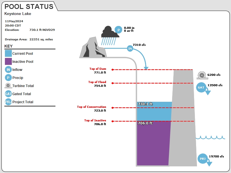
Streambed Elevation: 650.00 feet.
Top of Dam Elevation: 771.00 feet.
All storages based on a contributing drainage area of 22350 square miles or 1192053 acre-feet
Longitude: -96° 15' 6" Latitude: 36° 9' 6"
Map of Keystone Lake Dam
Go to Tulsa District Water Control Home Page.
Disclaimer: The Lake Pages are subject to change.Last Page Update: Friday, 24 May 2019 04:04
This is the only photo I found with the lower arms close to horizontal. Then I noticed it was taken in May, 2019.
Update: I just saw a view of Tulsa on the Weather Channel showing what looked like a downtown area under water. They were making a point that they are going to stay at the current flood stage for many days because even more rain is on the way.
http://www.swt-wc.usace.army.mil/KEYS.lakepage.html
ATTENTION: The release values for the graphic above are inaccurate.
Please use the bolded red release value below. Which is based on several measurements by the USGS
of the flow at the 71st street bridge in Tulsa. NO gate changes were made at Keystone Lake last night.
The current data for the gage mentioned above can be found HERE and HERE.
Thank you for your patience we are working to correct the issue.
Streambed Elevation: 650.00 feet.
Top of Dam Elevation: 771.00 feet.
All storages based on a contributing drainage area of 22350 square miles or 1192053 acre-feet
Longitude: -96° 15' 6" Latitude: 36° 9' 6"
Map of Keystone Lake Dam
Go to Tulsa District Water Control Home Page.
Disclaimer: The lake pages are currently undergoing changesLast Page Update: Wednesday, 29 May 2019 06:04
It looks like the river flow peaked a couple of days before the GREX train photo at 280 kcfps.
I really wish I could find a date on Facebook Reels.
Officials Encourage Flood Preparation as Keystone Dam Releases Go to 250,000 CFS "Water flowing into Keystone Lake should peak this afternoon around 320,000 cfs." The new Oroville Dam spillway design can do more than 200 kcfs, but I think the number is less than 250 kcfs.
A USACE spokesperson at around 27 seconds left in this video states that the channel's capacity is 105 kcfs and they are spilling just 86 kcfs, so no problem. I guess she hasn't got the memo about the 250 kcfs release!
I think a lot of the news articles I was looking at were using file footage for the video because the lower arm of the Tainter gates angled down. But here is a video where you can see that the first few gates on the left side have the lower arm at an almost horizontal angle.
 |
| Screenshot |
I found a video that was three days later and is flowing at 150kcfs.
 |
| 1:14 video @ 0:34 |
From http://www.swt-wc.usace.army.mil/KEYS.lakepage.html Note that the hydro plant has been shut down. Another thing I learned from the Oroville disaster was that when the downstream level gets too high, they have to shutdown the hydro plant so that it does not get flooded.
Current Readings:
- 32.31 ft ABOVE normal
- Pool elevation is 755.31 feet on Friday 24May19 Time: 0400 hours.
- At this elevation the total amount of water stored in Keystone Lake is 1631759 acre-feet.
- Reservoir release is 253161 cubic feet per second on Friday 24May19 Time: 0400 hours.
- Flood control pool is 106.30% full.
- Flood control pool storage filled is 1199839 acre-feet which is equivalent to 1.01 inches of runoff over the entire drainage basin.
- Flood control pool storage empty is -71159 acre-feet which is equivalent to -0.06 inches of runoff over the entire drainage basin.
Current Gate Settings:
- Tainter Gate 1 = 12.25 ft
- Tainter Gate 10 = 12.25 ft
- Tainter Gate 11 = 12.25 ft
- Tainter Gate 12 = 12.25 ft
- Tainter Gate 13 = 12.25 ft
- Tainter Gate 14 = 12.25 ft
- Tainter Gate 15 = 12.25 ft
- Tainter Gate 16 = 12.25 ft
- Tainter Gate 17 = 12.25 ft
- Tainter Gate 18 = 12.25 ft
- Tainter Gate 2 = 12.25 ft
- Tainter Gate 3 = 12.25 ft
- Tainter Gate 4 = 12.25 ft
- Tainter Gate 5 = 12.25 ft
- Tainter Gate 6 = 12.25 ft
- Tainter Gate 7 = 12.25 ft
- Tainter Gate 8 = 12.25 ft
- Tainter Gate 9 = 12.25 ft
Evaporation Data:
Daily Computed- 0.480 inches - 24May2019 @ 0700
Reservoir Data:
| Elevation | Incremental Storage | Cumulative Storage | |||
|---|---|---|---|---|---|
| (feet) | (inches) | (acre-feet) | (inches) | (acre-feet) | |
| Surcharge Pool: | 757.00 | 0.14 | 166522 | 1.46 | 1727123 |
| Flood Control Pool: | 754.00 | 0.95 | 1128680 | 1.32 | 1560600 |
| Conservation Pool: | 723.00 | 0.2 | 234756 | 0.37 | 431920 |
| Inactive Pool: | 706.00 | 0.17 | 197164 | 0.17 | 197164 |
Streambed Elevation: 650.00 feet.
Top of Dam Elevation: 771.00 feet.
All storages based on a contributing drainage area of 22350 square miles or 1192053 acre-feet
Longitude: -96° 15' 6" Latitude: 36° 9' 6"
Map of Keystone Lake Dam
Links for More Information:
Graphs of Measured and Calculated Lake Parameters:
View 24H and 1Day Graphs (Enlarged)
Keystone Lake near Sand Springs, OK
Go to Tulsa District Water Control Home Page.
Disclaimer: The Lake Pages are subject to change.Last Page Update: Friday, 24 May 2019 04:04
This is the only photo I found with the lower arms close to horizontal. Then I noticed it was taken in May, 2019.
 |
| T.J. Burrows |
 |
| TulsaWorld HWY 75 bridge crosses a swollen Arkansas River on Friday, May 24, 2019. TOM GILBERT/Tulsa World [Many of the photos before this one show that some zoning authority allowed a subdivision of houses to be built on a flood plain. But I could not find where "South 145th West Ave. near Oklahoma 51" is on the map. At the bottom of the gallery is a video that starts with the muddy waters pouring over the Keystone Dam.] |
Update: I just saw a view of Tulsa on the Weather Channel showing what looked like a downtown area under water. They were making a point that they are going to stay at the current flood stage for many days because even more rain is on the way.
 |
| weather.gov |
ATTENTION: The release values for the graphic above are inaccurate.
Please use the bolded red release value below. Which is based on several measurements by the USGS
of the flow at the 71st street bridge in Tulsa. NO gate changes were made at Keystone Lake last night.
The current data for the gage mentioned above can be found HERE and HERE.
Thank you for your patience we are working to correct the issue.
Current Readings:
- 33.89 ft ABOVE normal
- Pool elevation is 756.89 feet on Wednesday 29May19 Time: 06:00 hours.
- At this elevation the total amount of water stored in Keystone Lake is 1720862 acre-feet.
- Reservoir release is 272564 cubic feet per second on Wednesday 29May19 Time: 05:00 hours.
- Flood control pool is 114.20% full.
- Flood control pool storage filled is 1288942 acre-feet which is equivalent to 1.08 inches of runoff over the entire drainage basin.
- Flood control pool storage empty is 0 acre-feet which is equivalent to 0.00 inches of runoff over the entire drainage basin.
Current Gate Settings:
- Tainter Gate 1 = 13.25 ft
- Tainter Gate 2 = 13.25 ft
- Tainter Gate 3 = 13.25 ft
- Tainter Gate 4 = 13.25 ft
- Tainter Gate 5 = 13.25 ft
- Tainter Gate 6 = 13.25 ft
- Tainter Gate 7 = 13.25 ft
- Tainter Gate 8 = 13.25 ft
- Tainter Gate 9 = 13.25 ft
- Tainter Gate 10 = 13.25 ft
- Tainter Gate 11 = 13.25 ft
- Tainter Gate 12 = 13.25 ft
- Tainter Gate 13 = 13.25 ft
- Tainter Gate 14 = 13.25 ft
- Tainter Gate 15 = 13.25 ft
- Tainter Gate 16 = 13.25 ft
- Tainter Gate 17 = 13.25 ft
- Tainter Gate 18 = 13.25 ft
Evaporation Data:
- 0.147 inches - 29MAY2019 @ 07:00
Reservoir Data:
| Elevation | Incremental Storage | Cumulative Storage | |||
|---|---|---|---|---|---|
| (feet) | (inches) | (acre-feet) | (inches) | (acre-feet) | |
| Surcharge Pool: | 757.00 | 0.14 | 166522 | 1.46 | 1727123 |
| Flood Control Pool: | 754.00 | 0.95 | 1128680 | 1.32 | 1560600 |
| Conservation Pool: | 723.00 | 0.2 | 234756 | 0.37 | 431920 |
| Inactive Pool: | 706.00 | 0.17 | 197164 | 0.17 | 197164 |
Streambed Elevation: 650.00 feet.
Top of Dam Elevation: 771.00 feet.
All storages based on a contributing drainage area of 22350 square miles or 1192053 acre-feet
Longitude: -96° 15' 6" Latitude: 36° 9' 6"
Map of Keystone Lake Dam
Links for More Information:
Graphs of Measured and Calculated Lake Parameters:
View 24H and 1Day Graphs (Enlarged)
Keystone Lake near Sand Springs, OK
Go to Tulsa District Water Control Home Page.
Disclaimer: The lake pages are currently undergoing changesLast Page Update: Wednesday, 29 May 2019 06:04
| Home | News | Organization |
 |
| Bill Neill shared Joe DeCarlo Grex cars built by Ebenezer Railcar in West Seneca, Ny. Mark Abercrombie Going to have plenty work by the looks of it. Graeme Nitz posted May 30 2019 Eastbound Ballast Train with BNSF 4505 C44-9W and DP BNSF Executive 9701 SD70MAC. Arkansas River Tulsa OK |
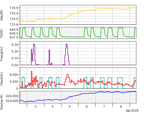
May 2025 Flood
%20Facebook.png) |
| Facebook Reel |
I really wish I could find a date on Facebook Reels.
%20Facebook.png) |
| Facebook Reel, near the beginning |
%20Facebook.png) |
| Facebook Reel, near the end |
It said a downstream gauge is unavailable. This is the lake level.
 |
| noaa |
Jul 2, 2025 is when this appeared in my Facebook feed.
%20Facebook.png) |
| Facebook Reel |
A photo from 2019 posted during the flooding of July 2025.
 |
| Virginia W. Metzger posted Keystone Lake on the lake side of the dam. Charity Crawford: This is an old picture from 2019 it is not current |
 |
| Amanda Baker commented on Virginia's post |
There are some photos and videos of the spillway in action in the comments. I saved this one because the figure for an Olympic side swimming pool of 88,000 cu. ft. was interesting.
 |
| Gerardo Madrid commented on Virginia's post Dale Glimp: Gerardo Madrid And that is wrong. They were releasing about 27,000 cubic feet of water per second. An Olympic size swimming pool volume is about 88,000 cubic feet. |
Flood of 2026
 |
| Facebook Reel |
No comments:
Post a Comment