(Update: 8 fun facts; 7 abandoned lines; some facts and nine images; Brian Morgan posted a history; 15:50 YouTube video mapping the evolution of the "L" from 1892-2029)
 |
| Michael Brandt posted Classic CTA. Bill Bielby: Looked like Lake Street to me. Sure enough - reverse image search - Lake and Oakley Streets 1893. About 20 years later my dad's mom and stepdad had an ice cream shop at the corner of Lake and Laramie. https://www.chicagotribune.com/columns/ct-cta-l-anniversary-getting-around-20170604-column.html |
 |
| Michael Brandt posted Classic CTA, subway construction at State Street. |
 |
| Brian Berthold posted 1908 Birds eye View of Chicago Elevated Railroads had to downsize to 25% of file size of 273 MB Tiff |
 |
| Jon Roma posted This item appeared in the Railroad Gazette's issue of August 21, 1896, and describes the signaling and interlocking on the Union Loop elevated. As stated in the article, over 1,000 trains a day traversed the Loop elevated, and that figure doesn't include trains from the North Side "L", which was not yet complete at the time this article was printed. The signaling facilities included several interlockings to protect the junctions concerned, in addition to torpedo placers to stop trains that had passed stop signals. With the Loop as heavily traveled as it was, and with much of the rolling stock made of wood, the consequences of a collision – even at low speed – could be catastrophic. I'll observe that, outside the Loop, and apart from interlocked junctions, most of the elevated lines lacked automatic block signaling until well into the CTA era (post-1947). Operation was largely "on sight", and there were a few rear-end collisions (many in foggy weather) caused by trains whose braking distance exceeded sighting distance. Today, all CTA revenue trackage is equipped with automatic cab signals and speed control. Wayside color light signals and tripstops are still featured on the Loop "L", and elsewhere, in order to supplement the cab signals and to keep the busy operation fluid. |
.jpg) |
| Ervin Eliud posted Comparing a 1930’s CTA map to today's, I've noticed numerous discontinued stops and new lines. Makes me curious about when the color scheme changed to its present design. C Alisa Guss: The current color identification for the ‘L’ trains was created In February 1993. Jack Rue: FWIW the *It's History* YouTube channel produced a related video ➡ https://www.youtube.com/watch?v=7NPCFnF4csA [The CTA did not exist until Oct 1, 1947.] Paul Webb shared |
 |
| John McEnery commented on Ervin's post |
 |
| 1938 Map from chicago-l LoopChicago has a similar map |
 |
| Rotwang Manteuffel posted 1940. Rotwang Manteuffel shared |
 |
| 1965 Route Map via Chicago-L |
 |
| Albeast One posted Map of the L from 1970. Resolution is 1080x1920 so it will fit your vertical monitor. |
Since Car #1 of the Alley L is on static display at the Chicago History Museum, that would be the subject of the following photos that were taken in the museum. [DRLOIH]


The State Street Subway was opened in 1943, but the Dearborn Street Subway was delayed until 1951 because of wartime rationing. During the 1950s, the Congress L was replaced by the route in the median of the I-290/ Eisenhower/Congress Expressway, and the Dearborn Street Subway was extended by 1958 to connect the new median route with the Milwaukee Line. This gets us to the system configuration shown in the 1965 map at the top of these notes. [Chicago-L-modernization]
 |
| 20140925 9921 |
"Other lines created by private companies between 1893 and 1900 included the Lake Street 'L,' (now the Green Line's Lake branch), the Metropolitan West Side 'L' (portions survive as parts of the Blue and Pink Lines), the Union Loop (now the Loop 'L'), and the Northwestern 'L,' which went to Wilson Avenue (now forming parts of the Brown, Purple and Red lines)." [DRLOIH] The Metropolitan West Side Elevated Railroad was the third one built in Chicago and the first to use electric traction when built. [GarfieldPark] The various companies were consolidated in 1924 as the Chicago Rapid Transit and in 1947 the system went public as the Chicago Transit Authority.
 |
| Marty Swartz posted Lake Street, looking west from Wabash Avenue, in 1896 when the “L” was being built. C. H. Cook received $50 dollars for this picture, printed in the Tribune. — Chicago Tribune historical photo Marty Swartz posted again with the same comment, but much lower resolution Paul Webb shared Arthur Sievers: That was a huge amount of money for a single picture. A lot of people did not make that in a month in 1896. [$1,683.78 in 2021] Historic Chicago posted Lake and Wabash, Construction of CTA tracks. (1895) |
The State Street Subway was opened in 1943, but the Dearborn Street Subway was delayed until 1951 because of wartime rationing. During the 1950s, the Congress L was replaced by the route in the median of the I-290/ Eisenhower/Congress Expressway, and the Dearborn Street Subway was extended by 1958 to connect the new median route with the Milwaukee Line. This gets us to the system configuration shown in the 1965 map at the top of these notes. [Chicago-L-modernization]
 |
| BDBRCPC posted Lake Street 'L' under construction near Washtenaw (early 1890s). On November 6, 1893, the Lake Street Elevated began passenger service from California/Lake to a terminal over Market Street (now Wacker) at Madison. This photo shows construction near Washtenaw (just a bit east of California Ave), looking east down Lake Street, in the early 1890s. Note the shop on the right selling wagons and buggies! It was Chicago’s second ‘L’ line and opened using coal-burning steam engines, towing trains of wooden trailer cars from downtown to the West Side. Raymond Kunst sharedCTA posted On November 6, 1893, the Lake Street Elevated began passenger service from California/Lake to a terminal over Market Street (now Wacker) at Madison. This photo shows construction near Washtenaw (just a bit east of California Ave), looking east down Lake Street, in the early 1890s. Aaron Grace shared Now part of today's CTA Green Line! |
 |
| Vanished Chicago posted CHICAGO – ELEVATED – UNDER CONSTRUCTION – EARLY 1890s – SOUTH PART READY FOR 1893 WORLD’S FAIR |
 |
| David M Laz posted DID YOU KNOW THAT? Once upon a time, there was an "L" stub that ran from the Lake Street "L" and ended in front of the Opera House on Market Street (now Wacker Drive). Alan Follett: Yes; the original downtown terminal of the Lake Street ‘L’, before it was connected to the Loop. It was abandoned in 1948. Leonard Carey Williams: Samuel Insull's station he owned the Opera House he owned the trains he would park his private car at the end of the line it was good while it lasted Paul Webb shared |
 |
| Nicholas J Vetrovec commented on David's post It was the fist section of the L built in the Loop and was part of the Lake Street Elevated rail known as the Market Street stub 1893. It was supposed to be removed in 1897 when they opened the fist section of the Loop but wasn't removed until 1948 leaving way to extend the double decked Wacker Drive. https://www.chicago-l.org/stations/market_term.html |

This map is after the Dan Ryan Line and the O'Hare extension were built, but before 1993 when the Howard Line was connected to the Dan Ryan Line and the Lake Street Line was connected to the South Side Line.
 |
| John Zolot posted Then, at some point, someone decided to re-name all the routes by color. Why? Happened on Daley's watch [Feb 21, 1993], inspired by cities like London, where I can attest colors indeed make things easier for tourists. |
 |
| Jim Arvites posted View from a bygone era of the Illinois Central Railroad Mainline going under South Side Elevated at 63rd Street on the southside of Chicago.  Looking south. The station on the right is 63rd Street, built originally as a grade level station. The station would be demolished and replaced with the IC office building. The photo was probably taken around 1893 when the track elevation to 67th Street was completed for the Columbian Exposition. Tracks have been raised and grade separated and the visible part of the Woodlawn Depot is the upper floor. This was shot in 92 or early 93 before the South Side Alley EL was completed with the bridge over the I.C. extending to the Terminal at Stony Island and the Fair Gate. In 1967, when I was a freshman at Northwestern University, some of us rode the "L" to Jackson Park to visit the Museum of Industry. I knew that ride was history because the Dan Ryan Route was built in the late 1960s and the south end of the State Street Subway was moved to that route in 1993. But I did not know that ride was also history until I saw this post because the "L" now stops at Cottage Grove instead of going to Jackson Park. A 1965 map: |
 |
| Matt McClure commented on Jim's post Same location, but decades later. Once the L was truncated running to Stony Island, these shots were history. Also important to note that 63rd Street had a streetcar, so with the right angle one could capture the L, the IC and a streetcar. |
 |
| Original Chicago posted View of a curve in the elevated railroad track at East Lake Street and North Wabash Avenue in the Loop community area of Chicago, Illinois, in 1909. The only corner of the Loop "L" that was never a junction. The name "The Loop", is older than the elevated tracks circling the downtown. The name comes from announcements made by cable car conductors who would yell out "This car is bound for the loop."...to differentiate between a run making a short turn or a run going to the carbarn. Cable cars had to terminate either at a turntable or loop around a block. This was ten years before the Loop "L" was finished in 1897. This was also the site of the 1977 "L" derailment. In the evening rush hour, a train rear-ended a train that was stopped at this corner causing four cars to fall to the street. 11 people were killed and several hundred people were injured. They call this accident the worst disaster in CTA history. Emerson Coates: I remember that day very well. I was a CTA bus driver then and my route was #4 Cottage Grove which ended at Randolph St between Wabash and Michigan. What I remember most that just a few days before that terrible accident.all employees were given a small lapel pin stating that 1976 was our safest year ever. Kinda ironic if you ask me.🙏😒 Gail Dean Cotton: If you're counting from the founding of the CTA in 1947, the worst disaster surely was the 1950 streetcar crash and fire at State Street and 63rd when 34 lives were lost and 50 more injured. The worst transit accident, which I recall vividly, was in 1972 when two Illinois Central (now the Metra Electric) commuter trains collided at the 27th street station, killing 45 and injuring 332. Glen Miller shared Abrego-Galindo Carmen: Operator error. Steven-Cindy Greenwald: Abrego-Galindo Carmen--He was fired for smoking weed. Tests weren't as thorough in '77 as they were later on, but they found several joints in his workbag. (SG) |
Two comments by Steven-Cindy Greenwald on Glen's share:
 |
| 1 I was working 3rd shift at the Sun-Times that night. We could see aftermath of the wreck from the newsroom, across the river, because of the emergency floodlights. In the morning, I watched the cars, minus their trucks, being hauled away on flatbeds. A foreman said they weighed 25 tons apiece, about four tons more than the Green Hornets. Wasn't the worst CTA accident ever...the 1950 disaster at 62nd and State killed 34 people, when CTA 7078 derailed at high speed and struck a gasoline tanker truck. (SG) |
 |
| 2 This is what I saw the next day. I was actually a little bit closer to the cars...just beyond the light pole.(SG) |
 |
| Bruce Spida-webb Collum posted Remember when the Green Line (Jackson Park B- train) went all the way to Stoney Island. Aaron Grace: It was one thing to not want to repair/replace the bridge over the IC; that I could understand. What was absolutely ludicrous was cutting it off at Cottage Grove upon rehabbing the entire current Green Line by 1996! At least you could still take it to University Ave before that which was notably closer to U.ofC. Cutting it off further west of there was beyond dumb! |
Today's [2020] map showing the change of the south end of State Street Subway and the truncation of the Jackson Park service. After a renovation of the Green Line from 1994-96, service was opened only to Cottage Grove with a decision to be made about service to Jackson Park. Also, the Pink Line now uses the Loop via the Paulina Connector instead of the Dearborn Street Subway, and the Orange Line was opened to Midway in 1993. Not shown is that the Milwaukee Route going all the way to O'Hare in 1984.
On Sept. 27, 1997 the CTA decides to scrap the 105-year old "L" line to Jackson Park and starts tearing it down with less than 24 hours publc notice. [Chicago-L-timeline]
 |
| TransitChicago |
 |
| Map via TransitChicago |
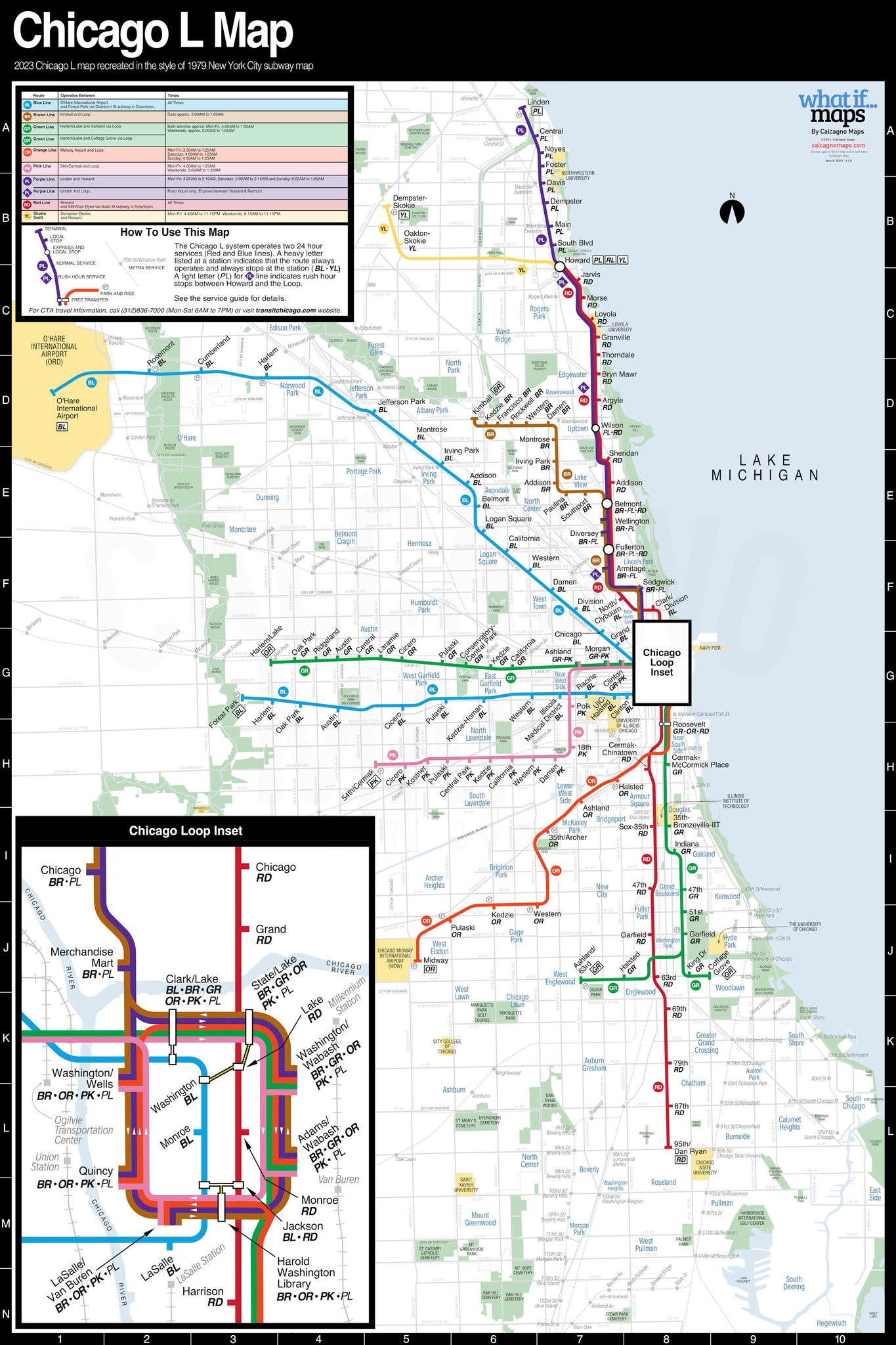 |
| Michael Calcagno posted 2023 Chicago L Map in the style of 1979 New York City Subway Map! Enjoy! Do let me know of any corrections 🙂 |
 |
| Michael Calcagno posted 2024 Chicago L Map in the style of 1967 NYC Chrystie St Connection Brochure Map! Damen St on the Green line is there that's due to open in 2024. Enjoy and let me know of any errors. Edit: Added 87th St on the Red line |
CTA posted seven images with the comment:
'L' system maps have varied in style and form over the years and taken on many styles.When creating the 2025 diagram, we looked to some of the best maps from around the world and our own historical maps for ideas, and decided on a diagram instead of an overly literal geographic map that spreads the system out more evenly across the artboard--which CTA used to do, including having the Loop integrated into the map.When adding the coming Red Line Extension to the 2025 diagram, we reconsidered the map so the extension didn't push all the content up where some might struggle to see more of the system higher on the map.Swipe to find the new 'L' system diagram you'll see in stations as crews make their way around the system, starting with the Red and Green lines before reaching all other stations.
Jason Fleigel shared with the comment: "Neat to see the L map from various years."
 |
| 1 |
 |
| 2 |
 |
| 3 |
 |
| 4 |
 |
| 5 |
 |
| 6 |
 |
| 7 |
The North Shore Line was an interurban line to Milwaukee that used the "L" to get to the Loop.
 |
| Mike Tuggle posted Looking north on Wabash Avenue at Van Buren Street in the early 1960s. North Shore Line's Electroliners were surely the most unique trains to ever operate on the Loop "L". These fast and comfortable streamliners made five round trips per day between between Chicago and Milwaukee, and had a lounge car that served beverages and light meals. Photo courtesy of Pete Busack from the Ed Halstead Collection. Philip Wizenick shared I rode Electroliners twice, the last time the day before the line abandoned passenger service. It was a snowy Saturday, and people were riding to Milwaukee from Kenosha rather than driving, seemingly unaware that the next day was the end. On the way home we picked up a load of sailors at Great Lakes heading into Chicago on Liberty. No one mentioned the bad news. Jeff Grunewald Where did it go south of the Loop? Philip Wizenick Layup on the center track at Roosevelt |
 |
| Philip commented on his share |
 |
| safe_image for Replacing the Loop ‘L’—Part One |
We all know that a picture is worth a 1000 words. I wonder if a video is worth a 1000 pictures. I never knew that services started being pulled back as early as 1903. Most of the initial construction was done by 1908.
 |
| 15:50 video @ 2:50 |
This video is terrific. One of the things I learned is that the necessity that mothered cable cars in Chicago was horse manure.
No comments:
Post a Comment