To skip the information about the bridge and go to the information about the Metropolitan "L" click here.
(Update: see Blue Line for the Garfield Park Branch replacement in the Eisenhower expressway.
William Shapotkin posted two photos with the comment:
Dave Jendras posted three photos with the comment: "a bridge now used only for signals on Chicago’s west side....."
Lee Jones posted four photos with the comment: "Bridge to nowhere. On Chicago's west side off Lake Street."
(Update: see Blue Line for the Garfield Park Branch replacement in the Eisenhower expressway.
Scherzer designed his rolling bridge for The Met's crossing of the Chicago River and the line terminated a few blocks east at the Wells Street Terminal.
A video of a Bruce Moffat presentation concerning The Met. He has three slides about the "bridge to nowhere" starting here.
You can skip ahead to the information about the Metropolitan West Side Elevated Railroad.
A New Short Answer
Most anyone familiar with history and/or operations of the 'L' in Chicago is no doubt aware of the "Bridge to Nowhere." This bridge, located west of Paulina Ave near Kinzie on Chicago's West Side once carried trains of the HUMBOLT PARK and LOGAN SQUARE 'L' lines over the (north-to-south) C&NW (Galena Division) -- now UP, MILW (C&M Division) -- now owned by METRA and the PRR (PCC&StL) -- now NS.Although the 'L' is long-gone, the bridge remains. It is used to support the W/B approach signals for Tower A2, which is located at Western Ave, less than one mile to the west. The bridge (as I understand it) is still owned by the Chicago Transit Authority (and if that be true, it is the only piece of the 'L' system which actually MAKES money for CTA). The approaches are long-gone (removed circa 1964-65). Many people has seen and/or photographed this bridge -- but how many have actually seen a photo of a train on it?1. Contemporary photo of the bridge.2. A vintage photo (taken circa 1950-51) of what appears to be a Loop-bound HUMBOLT PARK or LOGAN SQUARE trn about to head across the bridge. Bernard Stone Photo. Krambles/Peterson Archives.
 |
| 1 |
 |
| 2 Bridges Now and Then posted Met “L” bridge, Paulina and Fulton, Chicago, c. 1950. (Forgotten Chicago) Kevin Lucas shared |
 |
| Dennis DeBruler commented on William's post Location: https://www.google.com/maps/@41.8881746,-87.668139... |
 |
| Dennis DeBruler commented on William's post
This extract from a 1938 map shows the route that used the bridge. I added a blue line to show where it crossed the C&NW.
The opening of the Dearborn Street Subway in 1951 made this route obsolete.
|
 |
| William Shapotkin posted Prior to the February 25, 1951 opening of the Subway south of the North/Damen station on the LOGAN SQUARE (now O'HARE) 'L' in Chicago, trains operated over an elevated structure along the west side of Paulina Ave as far south as (what is today) the Eisenhower Expressway. Here is a photo of a N/B train operating on that structure, about to cross over the (now) UP/Metra MILW tracks at Kinzie/Paulina. View looks S/E. Although the elevated structure here no longer exits, the bridge over the railroad tracks does (it supports signals for the railroads underneath it) and is often referred to as "The Bridge to Nowhere." Photo dates from 1940s. Robert Wanner Collection. Dennis DeBruler shared We have seen some photos of this "bridge to nowhere" (https://maps.app.goo.gl/DG8fUGhPbXgxDq5p6), but this is a photo from when it went somewhere. It was part of the Pauline Connector (https://www.chicago-l.org/operations/lines/paulina.html) that now connects with the Lake Street route a few blocks south of here. William Shapotkin posted Have had this image for awhile and do not believe it has been posted here yet -- Back when "The Bridge to Nowhere" (located Kinzie/Paulina) actually when somewhere, trns of the LOGAN SQUARE/HUMBOLDT PARK 'L' crossed over tracks of the C&NW/MILW/PRR (PCC&StL). Here is a view, looking S/E of a trn on that very bridge! Notice all the frt cars stored up here at the time (most likely being switched by the PRR). Photo dates from the 1940s. From the Robert Wanner Collection. As an aside, the bridge is still owned and maintained by CTA and (as I understand it) Metra pays CTA for the use of the bridge. Therefore it is NOT abandoned. William Shapotkin posted Some time ago, I found this photo on a facebook page (and no, do not recall which one) of an 'L' train on the bridge over the PRR (PCC&StL)/MILW/C&NW at Kinzie/Canal in Chicago. The photo supposedly dates from the 1940s and looks S/E. The photo was credited as being from the "Robert Wanner Collection." A friend of mine (Bruce Moffat) is preparing an article for FIRST & FASTEST (a quarterly magazine published by Shoreline Interurban Historical Society), which focuses primarily on the electric railroads in and around Chicago and would like high-resolution copy of this photo for possible use in that publication. Might anyone be able to find out who has that collection and put me in contact with him/her -- or refer them to me? Any assistance you might be able to offer would be most appreciative. Feel free to PM me. Wendy Krapowicz posted Prior to the February 25, 1951 opening of the Subway south of the North/Damen station on the LOGAN SQUARE (now O'HARE) 'L' in Chicago, trains operated over an elevated structure along the west side of Paulina Ave as far south as (what is today) the Eisenhower Expressway. Here is a photo of a N/B train operating on that structure, about to cross over the (now) UP/Metra MILW tracks at Kinzie/Paulina. View looks S/E. Although the elevated structure here no longer exits, the bridge over the railroad tracks does (it supports signals for the railroads underneath it) and is often referred to as "The Bridge to Nowhere." Photo dates from 1940s. Robert Wanner Collection. Jeff Woodrick: The rail cars are on the PRR tracks. Joseph Obrien shared |
 |
| Mark Kaspar commented on William's first post The UP/Metra ( C&NW ) MILW tracks are all running parallel at the same grade. There clearly is a retaining wall here separating two distinctly different grades. I’m not sure this is the Met’ bridge. Bob Lalich: Mark Kaspar - the boxcars in the photo are on PRR team tracks that slope down to street level. The entrance to the driveway was on Wood St. |
 |
| Mark Kaspar commented on Bob's comment You’re right, Bob! The retaining wall still exists. It’s covered up by some foliage but there it is. The Pennsylvania’s team tracks are long gone, but you can see where they were from this shot… |
 |
| William Shapotkin posted No doubt, most have seen numerous pictures of the so-called "bridge to nowhere," the bridge which once carried trains of the Logan Square & Humboldt Park 'L' lines over the CN&W/MILW/PRR (PCC&StL) tracks. Well, lo and behold, another photo of that bridge has surfaced, showing the bridge when it actually went somewhere! Am sharing same with you now. Here is an undated photo of an E/B MILW psgr trn x/o under the 'L' trks. View looks west. The 'L' bridge remains in-place today, supporting signals for the trks below it. The CTA still owns and maintains the bridge and CTA receives rent from Metra for its use -- thus the bridge is NOT abandoned! Photo from the Krambles-Peterson Archive. Albert Carello: The PCC&ST.LOUIS is now the NORFOLK & SOUTHERN RAILROAD. William Shapotkin: Albert Carello That is correct -- although it is my understanding that the NS no longer operates thru here, as their last customer (at Racine Ave) is gone. Paul Webb shared Dennis DeBruler shared with the comment: "The 'L' route that used this bridge was made obsolete by the Dearborn Subway that is now used by the Blue Line." Dennis DeBruler: Location: https://maps.app.goo.gl/2Tm8HR4JeCRYaTGf6 Lou Gerard: This photo is from the Krambles-Peterson Archive. Please credit. [I updated the above description because William updated his description.] Bob Lalich: Lou Gerard, William Shapotkin - I believe the photo is by AW Johnson. |
 |
| Evan Stair shared Chicago Subway 1946 Looking west from Paulina Street, between Ellen and Milwaukee Avenues, across the bulkhead [foreground] from which the subway will emerge to connect with the elevated track in March 1946. https://www.instagram.com/p/0tJLGxKS70/ Xavier Quintana posted From Vintage Tribune: Looking west from Paulina Street, between Ellen and Milwaukee Avenues, across the bulkhead [foreground] from which the subway will emerge to connect with the elevated track in March 1946. (Vintage Tribune) Paul Webb shared Joseph Obrien shared |
 |
| Dennis DeBruler commented on Evan's share After they removed the north/south track that curved to the left and built track that ramped down into the subway. https://www.google.com/maps/@41.904343,-87.6688469,124a,35y,304.84h,51.4t/data=!3m1!1e3 |
 |
| Dennis DeBruler commented on Evan's share It is the removal of that north/south track that caused this "L" bridge to become what may be the world's largest signal bridge. https://www.google.com/maps/@41.8886021,-87.671868,158a,35y,90h,39.43t/data=!3m1!1e3 |
I think this is a new view of the bridge.
 |
| Leonard Cary Williams posted Bridge to nowhere....ex elevated train bridge ...connecting rail removed ..60 years ago +- Wood St over C& NW tracks west main out of Chicago |
The Original Long Answer
The above was cropped from a photo similar to the following. This was taken from Racine Avenue while getting photos of Pennsy's positional signal heads before they were replaced with the PTC stuff at Control Point Morgan. The buildings on the left are the ADM Flour Mill. Their days are also numbered.


 |
| Philip Wizenick posted Chicago's bridge to nowhere. In 1951, the Dearborn/Milwaukee subway opened, replacing the elevated segment paralleling Paulina Ave. between Lake St. and Milwaukee Ave. The only evidence remaining of the elevated segment is this bridge spanning eight tracks. Four tracks to the left used by the Chicago & North Western, now Union Pacific Metra West Line. And four Union Station tracks to the right used by the Milwaukee Road, now Metra's Milwaukee District. This bridge continues to support railroad signals. |
 |
| Steven J. Brown posted Metra F40PH 110 passing underneath the abandoned Metropolitan West Side Elevated bridge (built 1898, abandoned 1964 - remains as a signal bridge.) November 5, 2001. |
 |
| 20171122 8119, cropped |
 |
| Steven J. Brown posted Amtrak Empire Builder #8 at Wood Street in Chicago, Illinois - March 16, 2024. Steven J. Brown shared |
 |
| Steven J. Brown posted Amtrak Hiawatha #336 is at Wood Street in Chicago, Illinois - December 20, 2023. NPCU 90221 was built in 1976 as F40PH 221. It is painted as a salute to veterans. Ken Kornfeld: One of the F40s was retired with 5.5 million miles. Steven J. Brown shared |
 |
| Steven J. Brown posted Union Pacific GP15N Y711 (built 1982 as MP 1711) in Metra service runs light from downtown to the coach yard at Wood Street in Chicago, Illinois - December 20, 2023. Tim Shanahan: What's the above bridge? Auto or railroad? Steven J. Brown: Tim Shanahan http://industrialscenery.blogspot.com/.../the-met-and-its... |
 |
| 4:05 video |
 |
| 1 |
 |
| 2 |
 |
| 3 |
 |
| 1 |
 |
| 2 |
 |
| 3 |
 |
| 4 |
 |
| Steven J. Brown posted The daily migration of Metra lite power from 40th Street to the California Avenue coach yard or Ogilvie always reminded me of the end of Charlottes Web when all the baby spiders spin sails and go floating into the sky asses first. An outbound Metra Milwaukee Line with a F40C waits in the distance while two loose F40PH's float through the plant (asses first) on their way downtown to look for trains. Tower A2/Western Ave in Chicago, Illinois - November 25, 1991. Dennis DeBruler The former "L" bridge in the background. Now it is just a signal bridge. This "L" route was replaced by the Dearborn subway. |
 |
| Paul Webb shared Al Krasauskas' post 1905 track elevation construction photograph of the Chicago & Northwestern Railway Company tracks when they were still at grade level. The cross street is North Paulina Street with West Kinzie Avenue running parallel along side the RR tracks. View is looking west from just east of North Paulina Street. Photo catches a photographic (long exposure) ghost train on the overhead railroad bridge. Who recognizes that overhead RR bridge? [A reminder that when they elevated the railroad tracks in Chicago they first had to elevate the "L" tracks that went over them.] |
 |
| Pablo Marin Jr. commented on Al's post I have seen that bridge structure many time and actually took a picture of it a couple weeks ago I was going to post it here and ask if it was originally used for something else than signals? |
Metropolitan West Side Elevated Railroad
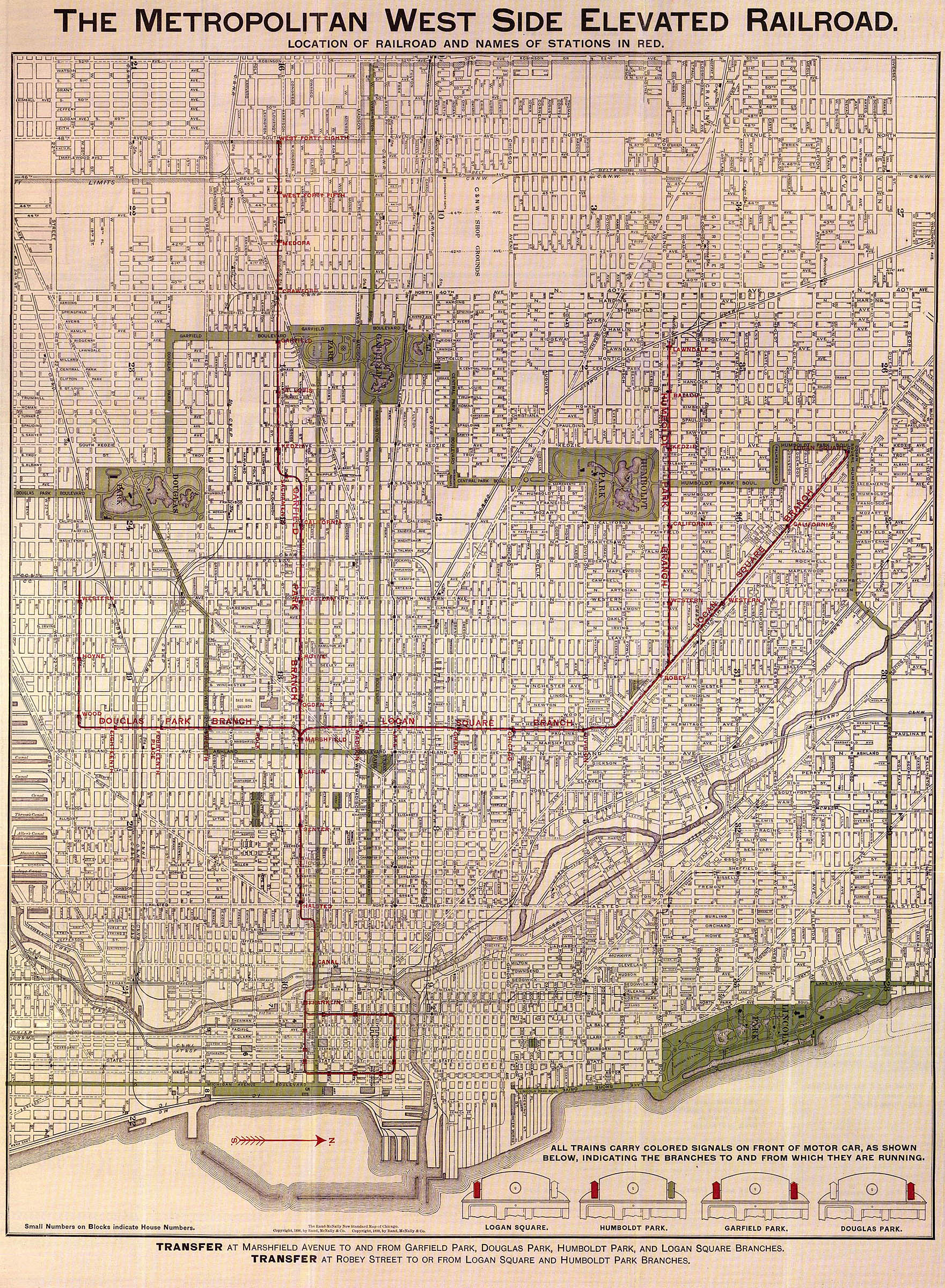
The Metropolitan West Side Elevated Railroad was the third one built in Chicago and the first to use electric traction. [GarfieldPark] We have already seen the Met because it used the first Scherzer designed rolling bridge to access its Fifth Avenue/Wells Street Terminal. I include this 1898 map to make it easier to understand the routes of the Met.
This shows how The Met crossed the river and joined the loop.
Then the Humbolt Park Branch left the Logan Square Branch just west of Robey Street (now Damen Avenue).
I include a detail of the loop area because it appears the Met started with a connection to the loop and added its Fifth Avenue/Wells Street Terminal later. The 1938 map below shows that the main line and the Douglas Park branch were extended. Furthermore, the CA&E connected to the west end of the main line.
Zooming in on the downtown connection, we can see that the Met connected to both its terminal and the loop. All of the CA&E trains went to the terminal.
Construction of the Milwaukee-Dearborn subway started in March 1939 using the deep bore method for most of the distance. But construction was put on hold during World War II even though it was 80% complete in 1942. Work resumed in late 1945 and opened on February 25, 1951. [DearbornSub]
The CTA took over all elevated and surface transportation in 1947. One of the first things it did was study the traffic through each station and on each branch because it wanted to close those facilities that did not generate enough revenue. Humboldt Park branch was on the "cut list." For political reasons, they could not just "pull the plug." So they reduced the quality of the service until the branch died. The following "bullet information" is from [Humboldt].
Update:
Chad Brown posted three photos of the abandoned bridge. You will have to follow the link because at least one of them is copyrighted. Some of the comments are of interest.
David H. Nelson posted three images with the comment: "I'm often pokin around on the hunt for pictures of old Chicago buildings and today I was in Google Street view screen-shotting the Brooks Building, W Jackson at Franklin (first picture) and on moving hte camera down Franklin to get a shot of the south side of hte building I noticed low building next door (second picture) and thought wait a sec, what is this???. It was once a substation. What makes it an item of interest for this forum is before the CTA starting shutting down terminal stations there was an elevated station immediately above this building. It was the terminal for a line coming off the westside. Basically it filled the gap above the substation, wall to wall left to right.. Entrance to the station was on the opposite side. The 3rd image is part of the 1950 Sanborn map."
Rick La Fever This was actually the terminal for The Roarin' Elgin. AKA, The Chicago, Aurora and Elgin Railroad also known as The Great Third Rail or Sunset Lines. It ran from this point through the Western Suburbs until it got to Wheaton Illinois.
At that point it split into two separate lines to run to Aurora and Elgin. It was abandoned at 1200 Noon July 3rd, 1957 stranding their passengers in the downtown Chicago area.
Bruce Moffat The single story building has always been a Rapid Transit substation and still is. The Wells terminal backed up to it at Street level and the platforms were overhead. Owned always by the "L". The CA&E was a tennant.
Paul Musselman It was originally a 'stub end' terminal for the CA&E....the Garfield El would pass this term. and access the 'loop' El by a connection on the west end of Van Buren...when CA&E was terminated, (along with the planning for Congress Exp'way) the stub end term. tracks were connected to the 'loop' at this point, and the west end Van Buren connection removed.
Mitch Markovitz The terminal was built by the Met "L" for their use as the Loop was becoming even then too crowded. When the agreement for trackage rights was reached with the Aurora Elgin and Chicago Railway the interurbans then began using Wells Street. Until 1951 Rapid Transit trains used the terminal for some Douglas, and Westchester trains. In 1955 the top floors of Wells Street were removed to allow the Garfield trains to access the Loop when construction of Wacker Drive dictated the removal of the old access.
Mitch Markovitz By the way Bruce Moffat is indeed the expert in this.
The abandoned bridge goes over UP/C&NW tracks on the north side of the easement and CP/Milwaukee+NS/PRR/Panhandle tracks on the south side.
Gary J Sibio shared another view of this bridge.
Larry J. Pearlman posted a photo taken from underneath the bridge.
cmraseye Flickr 2009 photo of the bridge to nowhere
While trying to find where the first picture of this UP article was taken, I discovered that the Blue Line uses a subway to connect the Logan Square branch with the new extension to O'Hare built in the median of I-90/94. The subway goes under Milwaukee Ave. then north under Kimball Ave. until it reaches the Kennedy Expy.
Arvy J. Novahtskee posted a photo and the comments contain a lot of information including a video of it burning in 1996!
VintageTribune photo of dismantling the Paulina Street Elevated
 |
| 1898 Map from a map collection |
This shows how The Met crossed the river and joined the loop.
.jpg) |
| Brian Berthold posted old loop map found online |
The first thing one learns is that back in the 1800s, the north/south streets were numbered avenues because the main line, Garfield Park, ended at 48th Avenue in 1898. Using the BRC tracks as a reference, it appears that 48th Avenue is now Cicero Avenue.
Jon Roma commented on a post: (The comments on this post also talk about the abrupt shutdown of the CA&E during the noon hour on July 3, 1957.)
The Metropolitan West Side Elevated consisted of three routes. These routes either terminated at the Wells Street station (between Jackson and Van Buren), or circled the Loop "L" from a connection at Van Buren and Wells.Of particular interest were the two branches a little west of Ashland Avenue: Logan Square (discussed more below) turned to the north and Douglas Park turned to the south.
The routes were the Garfield Park "L" (the main line), the Logan Square "L" (with its branch to Humboldt Park), and the Douglas Park "L". This route was used by the Chicago Aurora & Elgin, all of whose trains terminated or originated at the Wells Street terminal and didn't use the Loop "L". The Metropolitan had a major yard at Laramie, and from that point westward ran on CA&E's track -- at one time operating as far west as to 22nd Street and Mannheim Road in Westchester!
 |
| 1898 Map, zoomed |
 |
| 1898 Map, zoomed |
 |
| 1898 Map, zoomed |
 |
| 1938 Map from a map collection |
 |
| 1938 zoom |
Construction of the Milwaukee-Dearborn subway started in March 1939 using the deep bore method for most of the distance. But construction was put on hold during World War II even though it was 80% complete in 1942. Work resumed in late 1945 and opened on February 25, 1951. [DearbornSub]
The CTA took over all elevated and surface transportation in 1947. One of the first things it did was study the traffic through each station and on each branch because it wanted to close those facilities that did not generate enough revenue. Humboldt Park branch was on the "cut list." For political reasons, they could not just "pull the plug." So they reduced the quality of the service until the branch died. The following "bullet information" is from [Humboldt].
- In 1948 they switched to just a Lauwndale-Damen shuttle during off hours forcing everybody to walk over to a Logan train at the Damen Station. During rush hours, Humboldt trains ran downtown, but they terminated at the Wells Street Station rather than run on the loop like the Logan Square trains did.
- On February 19, 1950, they eliminated late evening and owl service.
- In December, they re-equipped Logan branch with brand-new, all-steel PCC 6000-series cars but kept the old wooden cars on the Humboldt branch. Sure enough the ridership on Logan went up and on Humboldt went down.
- The CTA planned to close the branch when the new Milwaukee-Dearborn subway opened in Feb. 1951. But local alderman Geisler (34th) and resident petitions gave the branch a reprieve. However, the CTA did close the Paulina Connector for revenue service and reduced the branch to just a shuttle service at all times. Furthermore, the transfer to a reconfigured Damen station that accommodated the subway connection was made very inconvenient for the passengers.
- Another change in Feb. 1951 was that they quit maintaining and cleaning the branch, "causing immediate and obvious deterioration in the stations."
- Service was discontinued on May 4, 1952. An express bus was added on North Avenue that stopped at just the Humboldt station locations. It was extended west to Kostner to tap commercial and industrial areas.
- The express bus service was terminated Sept. 10, 1973.
In case you thought I forgot that this posting was about a bridge, let's take a closer look at the Paulina Connector bullet item. First of all, one reason for including the 1938 map was to show that Lake and the Met were competitors for west side traffic in the 1800s. But after the CTA got control of all of the lines, they used the Lake Line to carry the Douglas Park (Pink Line) traffic into the loop. So the north/south segment of the Logan Branch south of the Lake Line is back in revenue service. The north segment, between the Lake Line and where the Logan Branch switched to the subway is abandoned. All of that abandoned segment has been removed except for this bridge. The reason the bridge is retained is that C&NW had hung signals on it while it was still in service. So the bridge now might be the world's largest signal bridge (Birds-Eye View, Street View)
Update:
Chad Brown posted three photos of the abandoned bridge. You will have to follow the link because at least one of them is copyrighted. Some of the comments are of interest.
 |
| Mike Breski posted ghost-of-algren: Chicago Aurora & Elgin in Chicago 1951 , by Mark LLanuza on Flickr. Mark LLanuza Flickr The CA&E has just left Wells Street station and is crossing over the shed of Union Station at Canal st [taken by unknown photographer] .Within the following year the CA&E will no longer come this far do to the building of the new Congress express way.Photo collection Mark Llanuza John L Garcia Four tracks over the Chicago River ❓ Dennis DeBruler Indeed. Two Scherzer rolling lift bridges side by side. http://industrialscenery.blogspot.com/.../metropolitan-l... Jon Roma Four tracks all the way west to Marshfield Ave., where the line split into three branches. Eric Larson Burlington building (547 W Jackson) has an angled back side which was to accommodate this r-o-w. A few pieces of foundational evidence remain in the west side of the river. Finally, the squat substation building at 321 S Franklin, which would once have been beneath this “L”, still stands under CTA ownership. |
 |
| Len Marcus commented on Chad's posting Not my photo but this is how the line looked, the bridge is in the background. John M. Kawano Curving line still exists- is now part of the Pink Line. |
 |
| Make Lehman posted Marshfield Junction Scott Greig With the separate CA&E platform in the foreground. Dennis DeBruler Metropolitan West Side Elevated Railroad where Garfield Park and CA&E went west, Douglas Park went south, and Logan Square went north. Douglas Park now uses a Logan Square remnant to get up to Lake Street as the Pink Line. The rest of Logan Square going north was made obsolete by the Milwaukee-Dearborn subway. |
And here is what went between this junction and the Chicago River bridge.
 |
| David Daruszka posted Here at Chicago Railroad Historians we do consider Interurbans, the 'L' and street railways as part of the city's heritage. Here's a two-fer with a four-car Chicago Aurora & Elgin train heading away from the Loop as a Chicago Rapid Transit train passes inbound. Below the train are the south platforms of Chicago Union Station. Don Sims photo from the Classic Trains collection. |
 |
| Kevin Heinlein posted Frank Piha: This was the Metropolitan. It consisted of the Douglas Park L the Garfield Park L and the Humboldt Part L. They all connected where today’s Pink line crosses the Eisenhower X-ray then ran into the Loop near Van Buren street. The bridge across the south branch of the river was removed many years ago. The Garfield Park line was also used by the CA&E inter urban railroad. Andre Kristopans: Notice EB 6000 on Market St.in distance. This is likely after Garfield was already in street further west, as this is a 3 car train. |
 |
| Len Marcus commented on Chad's posting The Met ran south from here; turned east at what now is the Eisenhower Expressway and went east over Union Station to the Loop. This photo shows the old Met Line as the Congress Expressway was being built. John M. Kawano Circa 1956-1958. The Congress (now Eisenhower) Expressway opened in 1956 but the median strip Congress CTA route was still under construction in this view; it opened on June 22, 1958. It uses the two tunnels to the right. The two tunnels to the left were part of a stillborn plan to route the interurban Chicago, Aurora, and Elgin Railroad downtown (it shared trackage with the old Garfield Park El) but the company ceased all commuter service at midday July 3, 1957. people who had taken the train downtown that morning were stranded! The Garfield Park El on the left had its route disrupted by construction of the Congress Expressway, which was a massive widening of old Congress Parkway. After the Halsted station the trains were rerouted in 1951 down a ramp to the surface and ran in the middle of Van Buren Street. Several grade-level crossings were created by this, slowing things down. To compensate somewhat all the stations between Halsted and Kedzie were eliminated. Nevertheless, many Garfield Park El riders switched to the paralleling Lake Street El. After the Congress route was opened the Garfield Park El was demolished completely. Of the five original Els in Chicago, the Metropolitan West Side Elevated has lost the most of its original route mileage. The only remaining parts are the Pink Line (formerly known as the Douglas Park or Douglas branch) and the section of the Blue Line between Logan Square station and Division/Ashland/Milwaukee station. |
 |
| Jim Arvites posted View from a bygone era of the Logan Square Elevated Terminal on the Northwest side of Chicago in 1895. (Joe Kopera Collection) |
David H. Nelson posted three images with the comment: "I'm often pokin around on the hunt for pictures of old Chicago buildings and today I was in Google Street view screen-shotting the Brooks Building, W Jackson at Franklin (first picture) and on moving hte camera down Franklin to get a shot of the south side of hte building I noticed low building next door (second picture) and thought wait a sec, what is this???. It was once a substation. What makes it an item of interest for this forum is before the CTA starting shutting down terminal stations there was an elevated station immediately above this building. It was the terminal for a line coming off the westside. Basically it filled the gap above the substation, wall to wall left to right.. Entrance to the station was on the opposite side. The 3rd image is part of the 1950 Sanborn map."
Rick La Fever This was actually the terminal for The Roarin' Elgin. AKA, The Chicago, Aurora and Elgin Railroad also known as The Great Third Rail or Sunset Lines. It ran from this point through the Western Suburbs until it got to Wheaton Illinois.
At that point it split into two separate lines to run to Aurora and Elgin. It was abandoned at 1200 Noon July 3rd, 1957 stranding their passengers in the downtown Chicago area.
Bruce Moffat The single story building has always been a Rapid Transit substation and still is. The Wells terminal backed up to it at Street level and the platforms were overhead. Owned always by the "L". The CA&E was a tennant.
Paul Musselman It was originally a 'stub end' terminal for the CA&E....the Garfield El would pass this term. and access the 'loop' El by a connection on the west end of Van Buren...when CA&E was terminated, (along with the planning for Congress Exp'way) the stub end term. tracks were connected to the 'loop' at this point, and the west end Van Buren connection removed.
Mitch Markovitz The terminal was built by the Met "L" for their use as the Loop was becoming even then too crowded. When the agreement for trackage rights was reached with the Aurora Elgin and Chicago Railway the interurbans then began using Wells Street. Until 1951 Rapid Transit trains used the terminal for some Douglas, and Westchester trains. In 1955 the top floors of Wells Street were removed to allow the Garfield trains to access the Loop when construction of Wacker Drive dictated the removal of the old access.
Mitch Markovitz By the way Bruce Moffat is indeed the expert in this.
 |
| 1 |
 |
| 2 |
 |
| 3 |
 |
| Jon Roma posted A week or two ago, someone asked about the location of the old pre-subway Logan Square terminal on what is now the CTA Blue Line. It turns out that this very question is answered by a photograph appearing in CTA's historical 2020 calendar. I've made a snapshot of the page in question, keeping the caption intact. This and other historic CTA calendars can be downloaded at https://www.transitchicago.com/historicalcalendar/. Andre Kristopans Building became a bank, but is essentially unrecognizable unless you saw the rebuilding in progress. Rotwang Manteuffel Originally, this branch came off the Congress "L" near what is now the Eisenhower Expressway and Rush-St. Luke's Hospital. When the Dearborn Subway was opened in the early '50s, it was connected to the Logan Square Branch. The branch's elevated tracks between Lake and Milwaukee were abandoned and torn down...Except for a truss bridge over the C&NW West Line which remains to this day. The bridge was left standing because it held signals for the railroad. Jon Roma If you want to be totally accurate, the Logan Square branch originally operated via the existing "L" structure next to Milwaukee Ave., headed south near Paulina Ave., and then joined the Douglas and Garfield branches near Marshfield and Van Buren, Logan Square trains thence traveling eastward, eventually circling the Loop "L" before making the return trip. A more direct routing to the Loop, and through-routing of lines was envisioned in the planning for the Milwaukee-Dearborn subway, and work began in March 1939. Though this subway was mostly complete by 1942, it was mothballed due to wartime shortages of labor and material. In 1951, the Milwaukee-Dearborn subway opened for service, and Logan Square trains were moved off the Loop "L" and into the subway, terminating at the La Salle and Congress station in the south Loop. The Congress line in the median strip of the expressway was inaugurated on June 22, 1958. Effective the same date, Douglas trains were taken off their temporary routing into the Loop via the Lake St. line. As of this date, Congress and Douglas trains were through-routed with Milwaukee (Logan Square) trains, and the La Salle and Congress station ceased to be a terminus. There's a log of good information on this subject (including maps) at www.chicago-l.org. There is also an excellent, well-illustrated article on the subject at https://forgottenchicago.com/features/remnants-of-the-l/. Dennis DeBruler This map is my goto reference for "The Met." http://www.chicago-l.org/maps/route/maps/1898met-map.jpg Where inbound trains now go North on the Paulina Connector between Van Buren and Lake, the inbound trains used to go South. Dennis DeBruler A key to The Met was that their trains, and the Chicago, Aurora & Elgin trains, crossed the river with the world's first Scherzer rolling bridge. Photo posted by Paul Petraitis, https://www.facebook.com/groups/ChicagoJunctionRadio/permalink/1999320210316877/ |
 |
| Marie Lopez posted Chicago’s main post office is the tall building in the background with Union Station in the foreground 1938 photo. Jack Kelly: This also is a good picture of the old Garfield Park L line that was torn down in the 50's. It ran along side Van Buren and Congress. I think there are still remnants of the bridge that crossed the river still there. Jack Kelly: Actually Union Station use to be two buildings. The one in the foreground in the picture was the concourse building and was torn down and replaced with office buildings in the 60's. The Union Station's main building that is still standing is seen on the right in this photo. Great photo though. remnants of the bridge that crossed the river still there. Paul Webb shared Roy Wojahn: There was an underground passage from the southside of Union Station (think CB&Q side) under Canal Street then up to the CTA station. Quick to get to the Loop. Dennis DeBruler shared This photo is from when the Union Station had two buildings. We are looking at the concourse building, which has been replaced by a skyscraper and a very confusing basement for train passengers. The headhouse, which is still standing, is on the right (West) in this photo. Note all of the coal smoke on the Old Post Office. This photo was also before I-290 so we get a rare view of the Metropolitan West between its bridge and its Canal Street "L" Station. https://www.chicago-l.org/maps/route/maps/1898met-map.jpg via https://www.chicago-l.org/maps/route/index.html |
 |
| Xavier Quintana posted Workmen use a crane to lower the upright section of the Paulina Street elevated line near Grand Avenue in 1964. The land under the structure will be sold to adjacent land owners. (Vintage Tribune) Joseph Obrien shared |
The abandoned bridge goes over UP/C&NW tracks on the north side of the easement and CP/Milwaukee+NS/PRR/Panhandle tracks on the south side.
Gary J Sibio shared another view of this bridge.
Larry J. Pearlman posted a photo taken from underneath the bridge.
cmraseye Flickr 2009 photo of the bridge to nowhere
While trying to find where the first picture of this UP article was taken, I discovered that the Blue Line uses a subway to connect the Logan Square branch with the new extension to O'Hare built in the median of I-90/94. The subway goes under Milwaukee Ave. then north under Kimball Ave. until it reaches the Kennedy Expy.
Arvy J. Novahtskee posted a photo and the comments contain a lot of information including a video of it burning in 1996!
VintageTribune photo of dismantling the Paulina Street Elevated
In Sept 2020, I got hit with a Double Doomsday. Both Facebook and Google changed their software. I said "changed" instead of "updated" because the new software is not better. In fact, Google's Blogger software is far worse except for a search function that works. For example, it has three bugs concerning photos and their captions. So I'm no longer copying photos and interesting comments from Facebook. I'm just saving the link. Unfortunately, some of the links are to private groups.
Another brief history of the bridge This includes a photo of the Logan Square Terminal that was replaced by a subway station.
No comments:
Post a Comment