Split Rock and Bridge: (Satellite, the RI tunnel has been daylighted. The bridges are lost.)
CO&P = Chicago, Ottawa & Peoria RR, an interurban.
 |
| Larry E. Bird posted The house at Lock 13 1900 roof line was east an west with two brick stacks. |
The rock that got split.
 |
| Towpath View, Sep 2023 |
 |
| Michael Nieslawski posted LaSalle Lock 13 and Lock Tender House on I&M Canal - Year Unknown Bruce Liebe: Great photo. Is the smokestack from the Blackball Mine? Michael Nieslawski: Bruce Liebe I believe so. [This post of a variant of this photo has the comment: "LOCK 13 AN UTICA CEMENT CO IN BACKGROUND. CANAL HOUSE ON RIGHT SIDE."] |
 |
| Larry E. Bird posted Lock 13 I &M canal. Limestone blocks were used. Some were used on Lock 14 in repair. From 13 |
Christie Pasieka posted two images with the comment:
Lock 13Story of Lock 13I have been creating a series of art pieces of history no longer standing, this is one of them below.
Don Lavotny: As a kid in the 1960s I remember riding my bicycle along the towpath east from LaSalle and finding the abutments which must have once been lock 13. At the time I had no clue what it was for.
 |
| 1 |
 |
| 2 |
 |
| Dennis DeBruler commented on Christie's post Could someone drop a pin on a map and share the URL for the location of this lock? Not even the Illinois Department of Natural Resources knows where the lock is. https://dnr.illinois.gov/.../doc.../imcanalwesthuntermap.pdf Christie Pasieka: Dennis DeBruler right about where the 93 is in the map. |
 |
| Dennis DeBruler commented on Christie's comment Thanks. Judging from this 1937 aerial photo, https://clearinghouse.isgs.illinois.edu/.../0bwy03036.jpg, it was about a third of the way from the creek crossing to Split Rock. I wonder why they built a dam and flooded the lock. |
Flooding the lock with a dam explains why the canal is so wide at the lock in Joe Balynas' Flickr photo.
Andy Zukowski posted four photos with the comment: "I&M Canal Lock 13 Photos from years past."
 |
| 1 |
 |
| 2 |
 |
| 3 |
 |
| 4 |
 |
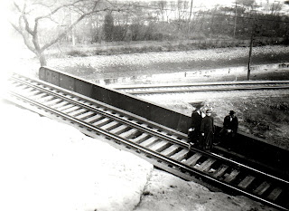
| Andy Zukowski posted Split Rock looking East…you can see the CO&P Interurban's right of way going up the grade to the top of split rock. It turned right at the top and crossed over the tunnel and canal. 1934-35 |
Andy Zukowski posted four photos with the comment: "Chicago, Ottawa & Peoria RR (interurban line) built in 1903 & removed after 1934, Illinois & Michigan Canal, LaSalle Illinois."
 |
| 1 |
 |
| 2 |
 |
| 3 |
 |
| 4 |
 |
| Michael Nieslawski posted LaSalle Interurban Bridge atop Split Rock - Looking South - Year Unknown |
 |
| Christie Pasieka posted Split Rock on Illinois-Michigan Canal Also known as: Camp Rock--before the "water gap" was cut thru it for the canal, after that it has been known as Split Rock (approx 2 miles east of La Salle, IL) A man-made water gap on Illinois-Michigan Canal west of Utica, IL I do have a series of photos and history of the Split Rock area. |
Andy Zukowski posted three photos with the comment:
Split Rock on the I&M Canal East of LaSalleThe area along the I&M Canal commonly referred to as Split Rock was once known as Camp Rock. During the building phase of the I&M Canal in the 1840's Canal workers were hired to dig the 96 mile Canal and faced many natural obstructions, as was the case between La Salle and Utica.In order to keep the canal straight the canal builders blasted part of the St. Peter Sandstone at Camp Rock, converting it from one solid rock to two separate rocks. From this point forward Camp Rock was referred to as Split Rock. In 1851 the Rock Island and La Salle Railroad Co., later to become the Chicago, Rock Island and Pacific Railroad, began construction of the first railroad tunnel in Illinois at Split Rock.By early 1900 the interurban track system was complete and a bridge spanning Split Rock was constructed to help bring Chicago Ottawa & Peoria interurban passengers from Utica to La Salle-Peru. In its heyday Split Rock was said to have had a beer hall, a shelter, a dance hall, and picnic area all located at the north end of Split Rock. In 1939 the bridge for the interurban was torn down. In 1941 the railroad bypassed the Split Rock tunnel with a new westbound track. Today visitors can still view Split Rock by traveling along the Illinois and Michigan Canal.
 |
| 1 |
 |
| 2 |
 |
| 3 |
Michael Nieslawski posted seven photos with the comment: "Misc. LaSalle Split Rock / Interurban Bridge - Photos - c1906."
Andy Zukowski shared
 |
| 1 |
 |
| 2 |
 |
| 4 |
 |
| 5 |
 |
| 6 |


No comments:
Post a Comment