Update: The Illinois Flickr Album contains some more pictures of this old bridge.
This street is also called East Romeo Road.
The current location as a trail bridge.
 |
| 20140518 022 |
The original location as the 135th Street Bridge. Note the sharp right-hand turn on the right (East) side of the bridge.
 |
| AlphaPublications, p1 |
 |
| Centennial Trail/I&M Canal Trail posted The swing bridge along the Centennial Trail was constructed in 1899 by Elgin Iron Works and erected by Strobel Steel Construction Company, according to a report from the Historic American Engineering Record (HAER) at the Library of Congress. For more than 90 years, the bridge – then known as the Romeo Road Bridge – carried traffic over the Chicago Sanitary and Ship Canal. The swing bridge closed to traffic in 1990 due to its deteriorating condition and it was replaced with a high-level bridge, allowing ships to pass beneath it. Because it was the last of its type, the swing bridge was saved and moved a few hundred feet away to the Forest Preserve District’s Centennial Trail in 1996. Centennial Trail is 26 miles long and it connects the Chicago Portage site at Harlem Avenue with Lockport. https://www.reconnectwithnature.org/news-events/big-features/harnessing-the-wilderness Joe Nicks: One spot on that bridge the bridge tender could not see when swinging. As a kid we used to ride the bridge. The bridge tender guy wasn’t too happy lol. Later on drove over the bridge too many times to count. And the old 16th St. bridge, talk about narrow! Mark Bilecki Sr.: I still remember driving over that bridge in the late 70 s, |
 |
| Jerry Jackson commented on his post Jerry Jackson updated I never did record when this was shot, but by the time I got back to Romeoville, the road had been closed and the bridge had been turned as you see it. It was a very interesting spot, I wish I'd taken more photos of the terrible east side ramp, narrow and littered with the chrome bumper trim and various colors of plastic light lenses, red and orange colors prevailing. Dan Tracy: That bridge had a 3 ton weight limit on it just before it was taken out of service. Brendan Smith: The 1993 & 1994 aerial shots show it in the open position. it was gone shortly thereafter. |
 |
| 1 of 7 photos posted by Chuck Edmonson THE ROMEO ROAD BRIDGE It's a nice job of preservation that reminds us of the technology of another era. When a new road and bridge was constructed in Romeoville (Will Co.) over the Sanitary and Shipping Canal near 135th Street and the Des Plaines River in the 1990s, it required the removal of the old bob-tail swing bridge. Swing bridges were quite common around 1900, usually pivoting from a center man-made 'island' allowing water traffic to pass through. The old Romeo Road Bridge as it was known was built in 1899, but was unusual in that it was a 'bob-tail' construction, not center swing but offset to one side. With construction of the new roadway the bridge was donated, disassembled and rebuilt a couple hundred feet away as part of the gateway to the Centennial Trail, a popular hiking and biking path. A great job of conserving part of the past of the area. Built in the unusual Warren truss configuration, the extensive bracing system of the design give it a eye-catching geometric design. The bridge tender with an eagle eye view from his position in the small shed within the framework. Even the old motor below the swing point remains intact, as if it could swing wide open today. [It is always interesting to see what views other photographers take.] |
In 1998, the MWRD moved the bobtail swing bridge a few hundred feet to be a trail bridge when the high bridge was built across the Sanitary and Ship Canal, SanteFe tracks, and I&M Canal.
Joe Balynas has turned taking pictures of a bridge into an art form: elevation, portal.
Almost from where I took a picture of the old bridge, I turned around and took a picture of the North side of the high bridge that replaced it:
 The white structure near the right side behind the bride is a coal unloading gantry for the power station that is south of the bridge.
Near the bridge was a sign explaining the retirement of the old bridge:

The text is:

And then I went across the bridge from the west end to the east end. Because the SantaFe route closely follows the canal, it has very few grade crossings because there are very few roads going across the canal. So this is the only place so far where the trains whistle for a crossing. So it is easy to catch pictures of trains from this location as in this picture of the northeastt quadrant of the crossing of the bridge and the canal. But are they still whistling for the grade crossing that was removed in 1990 when the old swing bridge was retired?

I digitally zoomed in on the engines because this is the first time I've seen a Canadian Pacific engine in a BNSF train. The consist was double-high container cars.

The oil refinery is currently owned by Citgo. It was owned by Union Oil in 1984 when an explosion hurled a 34-ton petroleum tower more than half a mile. Fortunately, it landed in a vacant lot beyond some houses. A retrospective written 10 years later reported that the cause was "faulty welding work performed when a section of the tank was replaced in 1974."
The view of the northwest quadrant is on an extreme angle to catch the old bridge in the background and the blue and white sign in the lower-left corner. The view down the canal on the west side is "just" trees.
 Below is a closeup of the sign. This reminds me that the Asian Carp Barrier sign said the electric dispersal barrier started at 135th street.

The southwest quadrant is a coal-fired power plant:

The beam in the upper-right corner is part of the coal-unloading gantry that we saw above in the second picture of this page. It is hard to see, but there is a second gantry parked at the other end of the coal storage yard. Notice the white "shed" just to the right of the middle smoke stack.
(The remaining photos concerning the power plant have been moved to the Will County (Romeoville) Power Plant notes.)
Further east, the bridge crosses the I&M Canal.
Update:
Jerry Jackson provided three photos concerning this bridge in a post.
Joe Balynas has turned taking pictures of a bridge into an art form: elevation, portal.
Almost from where I took a picture of the old bridge, I turned around and took a picture of the North side of the high bridge that replaced it:
Near the bridge was a sign explaining the retirement of the old bridge:
The text is:
The 135th Street bridge is the only remaining example of this type of bridge in the state of Illinois. Built in 1899 to cross the Chicago Sanitary and Ship Canal, it was uniquely designed to allow passage of large vessels along the waterway.
This two-span bridge was able to pivot on a steel turntable supported by a masonry pier; thus the name "swing bridge" as it swung across the water to the opposite ank. The longer east span was the part that actually crossed the canal, and the shorter west span functioned as the counterweight arm.
The trusses, which are the supporting framework. were constructed out of steel and extended up and over the bridge. Located within the trusses is an overhead pilot house where the movement of the bridge was controlled.
The bridge was a busy, acvtive bridge up until its removal and relocation; After its closing in 1990 due to structural problems, it was moved to Centennial Trail for preservation.
Let's Take a Closer Look
- Total length of bridge - 302 feet, East span - 204 feet, West span - 98 feet
- Total width of bridge - 26 feet, Road width - 18 feet, Walkway width - 5 feet
- Height from bridge deck to highest point of truss - 40 feet
- Statistics for 1989-1990: Number of closing per day - 7.7, Average closing duration - 15 minutes, Average vehicle crossings per day - 9000.
And then I went across the bridge from the west end to the east end. Because the SantaFe route closely follows the canal, it has very few grade crossings because there are very few roads going across the canal. So this is the only place so far where the trains whistle for a crossing. So it is easy to catch pictures of trains from this location as in this picture of the northeastt quadrant of the crossing of the bridge and the canal. But are they still whistling for the grade crossing that was removed in 1990 when the old swing bridge was retired?
I digitally zoomed in on the engines because this is the first time I've seen a Canadian Pacific engine in a BNSF train. The consist was double-high container cars.
The oil refinery is currently owned by Citgo. It was owned by Union Oil in 1984 when an explosion hurled a 34-ton petroleum tower more than half a mile. Fortunately, it landed in a vacant lot beyond some houses. A retrospective written 10 years later reported that the cause was "faulty welding work performed when a section of the tank was replaced in 1974."
The view of the northwest quadrant is on an extreme angle to catch the old bridge in the background and the blue and white sign in the lower-left corner. The view down the canal on the west side is "just" trees.
The southwest quadrant is a coal-fired power plant:
The beam in the upper-right corner is part of the coal-unloading gantry that we saw above in the second picture of this page. It is hard to see, but there is a second gantry parked at the other end of the coal storage yard. Notice the white "shed" just to the right of the middle smoke stack.
(The remaining photos concerning the power plant have been moved to the Will County (Romeoville) Power Plant notes.)
Further east, the bridge crosses the I&M Canal.
Update:
 |
| Gary Ekkert shared I know all of you Romeoville die hard will remember this Bridge? |
Jerry Jackson provided three photos concerning this bridge in a post.
 |
| 1 |
 |
| 2 I believe that this is a crop of a Thomas Kidd photo. [Just out of the frame to the left is the bridge. This clearly shows the dramatic turn the traffic had to make on the east side of the bridge.] |
 |
| 3 You can see this sign in the ramp picture above. |
The grade separation between the end of the ramp and the SantaFe tracks is why the road crossing was south of the road's route where it still crosses today.
 |
| 1954 Romeoville Quadrangle @ 1:24,000 |
.jpg) |
| EarthExplorer: Apr 23, 1973 @ 30,000, AR1VDCR00030094 |
I visited the bridge again on March 13, 2020. After taking some overview photos, this time I walked across the bridge taking detail shots both going and coming. The first set of machinery photos were taken on the west side and the second set is on the east side.


On a later visit to this bridge, I took photos of the barrier.


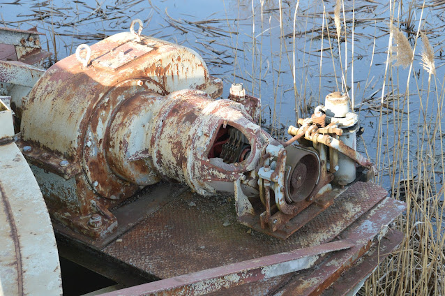
This shot was back on the West side to show what the above looked like when it still had its covers.


I again took some photos of this bridge on Feb 10, 2023.
 |
| 20200313 1684 |


On a later visit to this bridge, I took photos of the barrier.


No comments:
Post a Comment