 |
| 20150513 1427 |
(Update: the swing bridge before elevation and the straightening of the river. video of both bridges going down)
See the B&OCT Bridge that is next to this one for more views.
From Commission on Chicago Landmarks, Historic Chicago Railroad Bridges, p. 34:
The St. Charles Air Line (SCAL) Bridge was the world’s longest and heaviest single-leaf bridge when completed in 1919. Designed by the acclaimed Chicago bridge engineer Joseph B. Strauss, the SCAL Bridge was built using many of the design principles as the Chicago & Northwestern Railway Bridge (constructed in 1908). However, the SCAL Bridge is significant because it is an excellent example of a “heel trunnion” bascule bridge, a design developed by Strauss specifically for long bascule spans.
 |
| 20150502 0688 |
 |
| 0688 with brightness cranked up to Gimp 20 |
(Update: another picture from the 18th Street Bridge, Neil Gale's photo copy)
This bridge replaces a 295' long iron swing bridge that was built in 1882. That bridge was raised in 1898 when SCAL elevated the tracks. The iron bridge replaced a wooden swing bridge built in 1856.
On March 14, 1912 the U.S. Army Corps of Engineers ordered removal of the swing bridge. (The swing bridges had already been removed up by Wolf Point because they reduce the width of the navigation channel by more than half.) On March 23, 1914 the city council passes an ordinance "obliging railroads to cooperate in future straightening of South Branch of Chicago River." (HAER IL-157, p. 2)
 |
| Chicago and the World's Fair, 1933, p. 116, from Internet Archive |
The final configuration of the bridges.
 |
| David Daruszka updated |
Chicagology has a map that show the six phases of moving the river.
After the CREATE P4 (Grand Crossing) project is finished, Amtrak trains will no longer use this bridge. And after CN starts using the EJ&E rather than run its freights downtown to connect its routes over SCAL, what will happen to this bridge? At the end of an article, we read:
The label for this photo claiming the train is on the SCAL has to be wrong. It is going over the B&OCT bridge for two reasons. One is that the camera is facing west so it is going over the northern bridge. Two is that the SOO in 1959 was the original Wisconsin Central and used the B&OCT to access Grand Central Station.
Mark's comment:
Steven's comment:
Once Amtrak and Canadian National move the trains off St. Charles Air Line, the railroad may find a new lease on life. The 2009 Central Area Action Plan calls for it to be converted into a “recreational trail connecting to the lakefront.”
But before the city implements anything, it would need to get permission from all of St. Charles Air Line owners. Amy McBeth, BNSF Director of Public Relations for Midwestern states, indicated that the company has no intention of discontinuing its operations on the Air Line. At this time, it rarely uses the segment east of Chicago River, but it still reserves a right to use it in the future. McBeth did say that the company might re-evaluate its options once the Grand Crossing project is completed.
 |
Scott Janz -> Soo Line Historical & Technical Society
EB Laker over the St Charles Air Line.
|
 |
| Mark Hinsdale posted |
A momentary (and elusive) sliver of low winter sunlight illuminates Amtrak Train #3, the "Southwest Chief," as it departs Chicago on time for Southern California.Mark takes a lot of photos from the perspective of the MH Tower, but this one has a particularly nice catch of the viaduct that raises the trains over the yards and connects with the SCAL bridge. It is also a rare view of the B&OCT bridge in its "always up" position. Mark's looking east. Steven's photo below is looking west. It shows how the viaduct climbs up from BNSF/CB&Q's 16th Street yard to the Mark's part where it crosses the yards and connects to the bridge.
 |
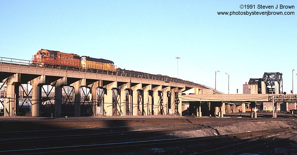
| Steven J. Brown posted |
A lot of action in this image from January 24, 1990 taken from the Canal St Bridge at 16th in Chicago. CNW SD38-2 6657 is on the St. Charles Air Line Bridge possibly on a transfer run to the IC or maybe doubling a cut in the yard. Two BN E9AM's 9910 and 9917 are making a yard move. One of the east coast Amtrak's with a lot of express business and F40PHR's is turning on the wye.
 |
| Mark Hinsdale posted [This westbound coal train is aview of a train coming off the incline to the viaduct to the bridge.] |
 | ||
| Steve Malachinski posted St Charles Airline facing East toward the river. Old BOCT and the Airline bridges over the river are in the back ground [This would be the viaduct that goes over the BNSF/CB&Q and Metra/Pennsy yards.] |
 |
| Steven J. Brown posted Amtrak City of New Orleans #58 crossing the Chicago River over the St. Charles Airline on its way to Chicago Union Station on February 8, 1991. |
 |
| Steven J. Brown posted Grand Trunk Western SW1200's 1512 (built 1960, became Great Lakes 1512) and 1514 (built 1960, became Burlington Junction 1514) are swinging off the St Charles Air Line onto the former Rock Island at 16th Street in Chicago, Illinois - February 5, 1988. Fred Mohr: The Chicago Rail Link was leasing it. Michael Buckley: Been over St Charles airline a lot on CN Coal trains 🚂 Steven J. Brown shared Edward Kwiatkowski shared |
 |
| Bryan Monaco posted, cropped Looks like the St. Charles Airline bridge, over the Chicago River, is out of service. The tracks are weed covered and there are no rails on the small bridge beyond. I have read the CN is rerouting the airline. [A comment provides a drone video.] Douglas Butler shared |
 |
| Mark Hinsdale posted A timely advance by Sayre Kos facilitated a rare opportunity to witness a 6 hour late, 15 car "City of New Orleans" come across the St. Charles Air Line and back around at "MH" for the final move into Chicago Union Station. In addition, arriving #6, and departing #3 all were in the mix, too, and all within a 15 minute timefrane. A little "fancy footwork" yielded these views of the tardy "star" of the show, #58. [A couple of comments indicated the train was longer than usual.] |
David Daruszka provided these three comments on a posting:
 |
| 1 |
 |
| 2 |
 |
| 3 |
A 1929 Tribune picture also showing both channels. Note the original B&O swing bridge still exists at the north end of the old channel. (Update: at least I thought it was a swing bridge. This indicates it was a rolling bascule bridge.)
 |
| MWRD shared South Branch straightening (Chicago Historical Society) Historic Chicago posted Aerial view of the straightening of the South Branch of the Chicago River near Twelfth Street, Chicago (1929) [The rest of the description sounds like AI generated platitudes.] Andy Ippolito shared |
 |
| Bob Olsen posted Jeff Bransky River City was built in 1986. There has been a lot of development north of Roosevelt Road and east of Clark Street since then. [I need to make a separate posting about the river straightening, but until then I'm saving this image here.] |
 |
| Bob Olsen posted Straightening the South Branch of the River in the 1920s. |
 |
| Original Chicago posted From : Chicago, the world's youngest great city. Published 1929 "Everyone familiar with the geography of Chicago knows that five of the north and south loop streets come to a stub-end at the southern edge of the loop, where they encounter the south branch of the Chicago River and the railroad yards that lie alongside it to the east and west. It must be apparent to any one that i( these five important streets (Dearborn, La Salle, Wells, Franklin and Market) could be opened through the railroad territory and aligned with south side streets, Chicago would take an immense stride forward in extricating itself from its street traffic tangle. After fourteen years of preliminaries, a new river bed in a straight north-and-south line is being dug. The present crooked channel will be filled in. After the railroads (owners of the land in the district) have settled upon the way they intend to use the land, the street projects can go forward." Glen Miller shared The South Branch of the Chicago River being straightened. Glen Miller shared with the same comment Daniel E Rowley: https://chicagology.com/harbor/straighteningriver/ Dennis DeBruler shared This view of the river straightening shows the original locations of the two Strauss heel-trunnion bascule bridges. The one on the left is the now "always up" B&OCT bridge, and the one on the right is the recently "partially up" St. Charles Air Line Bridge. The B&OCT bridge was built in its current location over the new channel. The St. Charles bridge was built over the old channel. It was then moved to the new channel when the old channel was ready to be filled in. As part of that move, it was shortened because it was designed to also fit the new channel. During this transition, the trains to Grand Central Station had to use the new bridge over the new channel and the old diagonal bridge north of Roosevelt Road over the old channel. Dennis DeBruler: I found the following link in a comment on one of the shares: https://chicagology.com/harbor/straighteningriver/. Almost a century later, Wells Street now goes south and connects with Wentworth Avenue. |
 |
| Dennis DeBruler commented on his share The grain elevator that was still standing in this 1920s photo was one of two Rock Island grain elevators. There used to be seven big grain elevators in this view. The development of the Calumet River Harbor moved ship traffic from the South Branch to the Calumet River. That is one of the changes that allowed the straightening of the river. This Sep 13, 1905, Metropolitan Water Reclamation District of Greater Chicago photo shows the St. Charles Air Line swing bridge before that route was elevated, the C&WI railyard and the Union & Armour grain elevators. But of particular note is the size of the steamers that used to come down the South Branch. It looks like the one on the left also has sailing masts. |
Michael Matalis posted the link with the comment: "More than you probably want to know about the St Charles Air Line bridge counterweights. Back in the days before 9-11 I used to walk across this thing to get to 16th St!"
This bridge has a Facebook page.
 |
| C&NWHS posted This is a photograph of the "St Charles Airline Bridge" the construction of which was funded by both the Illinois Central and the Chicago and North Western railroads. It replaced a center swing bridge at 16th street in Chicago over the not yet straightened Chicago River. Note that the concrete counterweights have not yet been added to the structure. See the next photo for the completed bridge which still stands unused just to the west of this position. The photo is dated June 9, 1919. The photo is from a book of 30 photographs detailing the construction of the bridge donated to the archives of the Chicago and North Western Historical Society by Charles Stats. Thank you, Charles! [BNSF/BN/CB&Q and NS/NYC/Michigan Central were also owners.] |
 |
| C&NWHS posted This is the completed "St. Charles Air Line" bridge at 16th Street over the not yet straightened Chicago River. The photo is dated May 1, 1920. The old center turn piling is still in place and will be removed as a hazard to navigation. The whole bridge was actually rolled to the west when the river was straightened. It still stands and can be seen in the permanently raised condition. The style of bridge is called a "jackknife draw." [It was also shortened when it was moved to its current location. It is not the permanently raised one on the north It is the one in use on the south.] |
C&NWHS posted three photos with the comment: "A neat item in the archives is a book of construction photos of the St Charles Air Line bridge which was completed in 1920. No mobile cranes to be seen, just derricks and other construction methods which probably would not be found today. 1st photo June 1920, 2nd photo July 1919, 3rd photo September 1918."
 |
| 1 |
 |
| 2 |
 |
| 3 |
 |
| The third of a sequence of photos posted by Mark Hinsdale
"Up, Up & Away"
One of the few instances in which freight on the BNSF Chicago Subdivision ventures as far east as Halsted Street on either Main Track 1 or 2 occurs, as today, when a train is destined for Canadian National by way of the "St. Charles Air Line." The "Air Line," owned equally by BNSF, Union Pacific and CN, provides a route connecting trackage of its three owners via a long, elevated, bridge structure over streets, other railroads, and the Chicago River on Chicago's Near South Side. The ramp ascending up the "Air Line" can be spotted in the 3rd and 4th images.
|
 |
| Steven J. Brown posted A pair of second hand Wisconsin Central SD45's on the St. Charles Airline at Canal and 16th in Chicago - February 10, 1991. |
 |
| Steven J. Brown posted Chicago South Shore and South Bend GP38-2's 2000 and 2009 descend the St Charles Airline in Chicago - February 10, 1991. Stan Stanovich ...though I never recorded the move on film...always out of position when hearing it was taking place on the scanner, back in these days CSS&SB occasionally delivered NIPSCO coal mtys to the C&NW(and UP) at Global One this way. The closest I've ever come to recording that move was light power returning at 16th and Clark after coming back across the "Air Line!!!" This looks like cold rolled coiled steel...excellent photograph Steven J. Brown!!! |
The first time I have seen a view of the viaduct from beside Canal Street.
 |
| Steven J. Brown posted
CNW SD40-2 6861 above Canal Street on the St Charles Airline in Chicago, Illinois - February 10, 1991.
|
 |
| Steven J. Brown posted
Before - middle - after:
Amtrak City of New Orleans arriving in Chicago over the St Charles Airline - April 1992, January 2002 and February 25, 2017.
|
 |
| Steven J. Brown posted South Shore GP38-2's yank a train up the St Charles Airline and over the Metra yard in January 1993. The E's were out of service and at least one sits below awaiting its fate. Rich Thielman Came from Proviso Yard.Fred Mohr The mixed freight cars are CNW Job 79 on the north track returning from interchanging cars with the IC at 31st St. They are stopped at Union Ave Tower waiting for the CSS to bring up their empty gon train on the south track out of Global 1. Back in the early 90 the CSS had a 52 car dedicated cold rolled steel train consisting of Gondolas and coil cars from Gary Steel to somewhere out west via CNW/UP all the cars had NADX reporting marks.Stan Stanovich ...good eye, or even better a little knowledge #FredMohr!...I can see it now!!!...though I made several trips from the east coast to Chicago between 1985 and moving here in 1995, I was only made aware of the cold rolled steel train to the North Western though a recent post by the very same Steven J Brown! From after moving here I was aware that CSS&SB would return mty Nipsco coal trains to Global One. I was always out of position when I'd hear about it on the scanner and my best efforts of catching it on film was recording the light power returning at 16th and Clark!!!...the above photo creates the illusion that there's one coil steel car on the head end and the rest of the train manifest freight!!!Fred Mohr I worked 16th St tower on and off from 1989 till 1996 when I became a dispatcher. Ironically I work in the Red brick building that is now directly north of the B&OCT at 15th and Canal. [I've never seen this view before. Probably because I think he had to get up on the B&OCT viaduct to take it.] |
 |
| Fred Mohr commented on the Steven J Brown's posting Me in 1991 showing the interlocking bed of the 16th St machine. |
 |
| ChicagoLoopBridges posted Hello Chicago! At airline railroad bridge. [April 15 was the first boat run of 2017.] |
 |
| Mark Hinsdale posted "Commerce" Chris Paciocco Wow, what a steep grade for that coal train!Mark Hinsdale Might be a bit intensified by the fact that the Amtrak train is actually going downhill, but the Air Line ramp is in excess of 2% |
 |
| 3D Satellite |
 |
| Steven J. Brown posted
THEN AND NOW:
Twenty-six years apart, Amtrak City of New Orleans #58 about to cross the Chicago River - February 8, 1991 and February 25, 2017.
[So the B&OCT Bridge was still down in 1991.]
|
 |
| Dan Marinellie posted
Amtrak P42DC #26 leads the southbound "Saluki" train #391 across the St. Charles Air Line. The St. Charles Air Line bridge was built in 1919.
Photo taken on 5/18/17 from the 116 year old 16th Street Tower with permission.
|
 |
| Carl Venzke posted Looing across the St. Charles Air Line Railroad Bridge, Chicago, IL - Photo by Kevin Dickert Danny Kelley Great shot, forgive me but why did they call it the airline bridge?Francis Otterbein St. Charles Air Line Railroad In 1852 the Chicago, St. Charles and Mississippi Air Line Railroad was chartered to run from South Branch Chicago River to the Mississippi River at Savanna via St. Charles. (An "air line" route meant a straight or direct route.) [Francis description looks familiar.] |
 |
| Mark Hinsdale posted
"Stormy Morning"
Chicago took on an unusual glow early this morning as thunderstorms passed just to the north of the Loop. And yes, there was rain in dem dere clouds...
|
 |
| Steven J. Brown posted Chicago Rail Link's ex-Rock Island GP18's climb the St Charles Airline as a Burlington Northern E9m heads for Aurora at 16th St and Canal in Chicago - July 18, 1991 [The CRL train is on the western ramp to the viaduct across the train yards and then the bridge.] |
 |
| Steven J. Brown posted Metra F40PH 112 heads for Aurora at 16th and Canal in Chicago - August 12, 2017. [The track in the foreground is part of the Jefferson Connection. The train is going under the viaduct for the St. Charles Air Line Birdge] |
 |
| William A. Shaffer posted Drawbridge at Amtrak Yard in Chicago (8.15.17) This Drawbridge has been in the "up" position since I began work at Amtrak in 1983. (Photo by William A. Shaffer) [The Air Line Bridge is on the right.] |
 |
| William Johnson posted We're on the Saint Charles Airline in Chicago back in May of 1980. I'd started my railroad career about a month earlier and I was posting on my first job, leverman/bridge tender at 16th St Bridge. The bridge was manned by B&OCT personnel. At one time, this was where the B&O long distance trains came east on the Airline and dropped down to the station after crossing the identical bridge to the left of this one. SOO Line SD40-2 6609 is on the point of the daily ICG Markham to Fond du Lac, WI freight, which will get on the old B&O passenger mains right here and head west to Madison St, where the train will gain home rails. I didn't take too many vertical format pictures. I would get dizzy from lying on my side trying to take the shot.... Mark E. Vaughan: With all the cracks and rebar showing I would guess that the cement gradually falls off. Must be difficult to keep the counterweight the proper weight. William Johnson: Mark E. Vaughan interesting, the B&B maintainer told me that the counter weights were so perfectly balanced that it took only a 40 hp. motor to raise the bridge. Rich Thielman: It was one of my favorite towers to work. Taking both bridges up at once was amazing! |
 |
| Barry Butler Photography posted This weekend’s [May 4, 2019] boat run on the Chicago River. What a city! [He had to be using a drone that day.] |
 |
| MWRD posted [So the foreground would be the new channel and the St. Charles Bridge is in its original location over the old channel.] The St. Charles Air Line Bridge is seen in this photo from October 16, 1929. The bridge was being relocated as a result of the straightening of the South Branch of the Chicago River. |
 |
| 20170421 8720, cropped |
 |
| 8723, cropped |
 |
| Karl Beetschen posted Rob Conway: Decommissioned CB&Q cab car visible with plated widows and antenna, beacon and horn holes patched on the roof. Timothy Leppert: Rob Conway You probably wore that car out.... Rob Conway: Timothy Leppert We both probably did. But, leaving the rails in one at 60mph is something I hope I never experience again. |
 |
| Henry Freeman commented on a posting |
Another photo of the approach on the west side of the bridge:
At first I didn't recognize where this photo was taken because I'm still not used to the view with the St. Charles Air Line being partially open.

 | ||
| Mark Hinsdale posted
"Split Second"
While out on the "porch" here at "MH" Tower enjoying Chicago's first 80+ degree day of 2018, I was treated to this spectacle. Up on the St. Charles Air Line, a tardy Train #390 from Downstate Illinois is arriving. In the middle, behind P42 195, Train #3 is departing town and accelerating west. In the lower right hand corner, the tail end of Train #49 from New York and Boston is seen, completing it's equipment turning maneuver. All three trains are moving, at different speeds, two in one direction and one in the other, and, against all odds, I somehow managed to record it. Happy May Day everyone!
This angle shows that St. Charles balance arm and counterweight was designed for the longer length when it spanned the old river routing.
|

 |
| James Clary posted Roosevelt Street Bridge - Chicago Dennis DeBruler The upright bridge behind it is the B&OCT, now abandoned. The span that is still down is the St. Charles Air Line, which many condo owners wish was abandoned. |
 |
| Forgotten Railways, Roads, and Places posted St. Charles Air Line Bridge on the right, and a former railroad bridge used by the B&O Terminal Railroad, now permanently upright on the left. Chicago, IL. |
 |
| Joe Dockrill shared |
 |
| Tapo Banerjee posted Amtrak Saluki (?) : 20-July-2020 ~12:40 PM@18th Street, Chicago [I was going to pass on this photo until I noticed that the St. Charles bridge is in the air. I got the impression from the comments that the bridge is in the air because they are doing repairs on it.] |
 |
| Carlos Ferran posted One Chicago area shot I've always wanted to grab was of a train passing the Pagoda in Chinatown. Unfortunately because of all the clutter with the crossing gates, the L, and trees, a ground shot wasn't possible. That changed with the addition of my drone. On a crystal clear August 8, CN M337 eases through Ping Tom Park and the Pagoda with a hefty lashup in tow. Seth Lakin DavidandLaura Greenberg the closer of the two bridges, that is not raised as high is the St Charles Airline, has been out of service all summer due to a construction mishap. The farther bridge raised higher, is the B&O has been out of service for almost 50 years. Matt McClure Seth Lakin Out of regular service. CSX would lower it as late as 1993 once a year to shuffle cars on the lone remaining Grand Central track to stave off abandonment claims from the city. Larry Klodt Just curious - I live in Waterloo, IA where M337 ends. Where does M337 originated at? I go to Chicago a lot and have been curious where the M337 and M338 end up. Thanks! Carlos FerranAuthor M337/8 originate/terminate at Kirk Yard. |
(new window)
(new window)
(new window)
(new window)
 |
| Screenshot @ -1:51 (source) |
 |
| One of five photos posted by Mark Hinsdale Dennis DeBruler What is the story about the St. Charles Bridge being up? Mark Hinsdale Dennis DeBruler repairs to the span and single tracking the Air Line thru 16th St. |
 |
| HalstEd Pazdzior posted CN train L537 experienced a mechanical failure on the trailing DPU unit (IC 1010). The train was split apart and half of the train was left on the main. Two rescue units were sent from Glenn yard to bring the rest of the train to its final destination. 8/23/20 Another view of the St. Charles Air Line Bridge in an open position. |
And it is still partially open.
 |
| Johnny Hansen posted Amtrak P42DC #189, or the “Big Game Train” and P42DC #59 shove the inbound Southwest Chief’s train set into the Coach yard past 18th Street on a sunny Labor Day afternoon. The Chicago Skyline and the St. Charles Airline Bridge can be seen in the background. 9/7/20 |
At first I didn't recognize where this photo was taken because I'm still not used to the view with the St. Charles Air Line being partially open.
 |
| Bart Shore posted Near South Side just a bit east of the Dan Ryan. Kenneth Oehrlein shared |
 |
| Dennis DeBruler commented on Kenneth's share At first, I did not recognize the location because I'm used to seeing the St. Charles Air Line bridge in the closed position. Does anyone know why it has been partially open for the last few months? |
 |
| Kevin Cluver posted Luke Balogh: Anyone know what the black squares on the counterweight are? Dennis DeBruler: Luke Balogh They are holes that make it easier to change the weight. The bridges in Chicago are balanced so carefully that they have to adjust the weight after each paint job. |
 |
| Dennis DeBruler commented on Luke's comment Here is a closeup of one of the counterweights for the Cermak Avenue Bridge that I took July 7 2015 to catch how the weight can be adjusted. This is not a railroad bridge, but the need to change the weight of the counterweight is the same. |
 |
| Kevin Cluver posted Dennis DeBruler: Normally the left bridge is down. So this is the first time I have noticed the control tower between the two bridges. I don't know why it has been stuck up since last Summer. The right bridge has been up for decades since B&O's Grand Central Station was torn down in the early 1970s. |
Another photo that catches the bridge stuck in a partially open position.
 |
| Mark Hinsdale posted "Winter Solstice" Arriving Amtrak Train #6, the 'California Zephyr," backs toward Chicago Union Station nearly an hour early on this shortest day of the year. Dennis DeBruler: And the St. Charles Air Line Bridge is still stuck partially open. |
Christopher Brandt posted the question: "Does anyone know why the Saint Charles Airline Bridge has been up all summer? How are freight moving from the IC to the BNSF?"
Very few make that move between the two class ones if at all.
The last thing I knew about running regularly was bnsf coal for michigan and the gtw. I imagine those trains can do the J at Eola and then pop onto the GTW at Griffith.
Metra would actually be a heavy user of the airline to transfer equipment from the Rock Island side to anything Union Station-related. They’ve instead been able to use the Root St Wye over the Dan Ryan since the bridge has been up.
Have you actually seen a train on that wye? I was under the impression it was OOS (owned by CRL) for some day when it because useful, and I'd like to catch something on it.
in May, yes
I was told by a reliable source it was undergoing maintenance, but that was a couple months ago.
Is CN still single tracking between 18th Street (Chicago Sub near McCormick Place) and 21st Street (Freeport Sub)? http://position-light.blogspot.com/2019/07/cn-cripples-chicago-16th-st-21st-st.html
 |
| Bryan Monaco posted Looks like the St. Charles Airline bridge, over the Chicago River, is out of service. The tracks are weed covered and there are no rails on the small bridge beyond. I have read the CN is rerouting the airline. Joe Dockrill shared |
 |
| Jonny Shworles posted Lumber St, Chicago Tim Shanahan shared |
The underpass east of the bridge "was for the connection between Grand Central and the C&WI for interchange of mail and express cars and through sleepers." [Harold J. Krewer comment on a post] That underpass is being removed and another is being built for the Wells-Wentworth Connector. It is nice to know that, after several decades, the plan to improve the traffic flow between South Chicago and the Loop is finally happening.

 |
| MWRD posted The Skim Pickens was pictured along the South Branch of the Chicago River this morning near Ping Tom Park. Our trash collection boat operates along the Chicago Area Waterways from mid-April to mid-October and after significant storms year round, unless weather conditions prohibit safe operations. Two debris collection boats improve water quality and the recreational experience for thousands of people canoeing, kayaking, boating, and enjoying the waterways. [The bridge has been partially up for over a year because a new overpass is being built east of this bridge.] |
 |
| The Rail Way posted A pair of bascule rail bridges cross the Chicago River a few miles from the city center. On the right, the St Charles Airline Bridge, constructed in 1919 by the American Bridge Company. It originally had a span of 260 feet (79m), but was reduced to 220 feet in 1930 when the Chicago River was straightened. The line and the bridge is now partly owned by Canadian National, Union Pacific, and BNSF. The line is not abandoned, but appears not to have been used for some time. The bridge on the left was built for the the Baltimore and Ohio Terminal Railroad, also by the American Bridge Company at the time of the river straightening in 1930, replacing an earlier structure. It is now officially abandoned. It is 186 (57m) feet long. Photograph: 11 May 2022. John Gatt: Something I read stated, the design of these particular bridges makes the fixed bridge necessary for the other to operate. William Cope shared My photo... |
 |
| Dennis DeBruler commented on William's share Dennis DeBruler: It was taken out of service to add an overpass just east of the bridge. But I see that the overpass has been installed. Since satellite images have a time delay, I don't know why it is not being used again. In the meantime, Amtrak has been using the CN branch to the south and then backing up on the NS/Pennsy route. https://goo.gl/maps/gUAwE9WwRB4UVCNi9 [Mark Rowland commented on a post: "something about Amtrak cutting an electrical cable by accident and nobody can agree who will pay to fix it."] |
 |
| Jun 23, 2023: Keith Ronald posted After about 3 years the south rail bridge is down getting ready to be used again. |
 |
| Erik Fox commented on Keith's post Must’ve just missed it |
 |
| Joe Rybakowski commented on Keith's post Another view. Wonder when they will start running Amtrak back over it? |
 |
| Charles Valentino commented on Keith's post Last Saturday night. |
 |
| 1 of 4 photos posted by Arlyn DS Non-working RR bridge (from 1919) over the south branch of the Chicago River. It is checked for operability once a year although there are no plans to resume using it. I asked why it wasn’t removed and was told it would cost too much money. Richard Fiedler shared John Curtin: The B&O bridge is dead, the St Charles Airline bridge on the left will be back in service some day, likely after they finish all the work related to the Wells Connector. Richard Fiedler shared |
Desktop Background:

Lawrence Smith there are some great pics of the reconstruction/elevation of the B+OCT tracks after the river was straightened - both sides of the river.- on the B+OCT FB site. One shot looking straight down from either the B+O or Airline Bridge to the temporary track construction from B+O station to the Air line bridge..
In the background of the steam locomotive NKP 765.
Metra SW1500 approaching the bridge
In the background of the steam locomotive NKP 765.
Metra SW1500 approaching the bridge
Long before the South Branc was straightened, the North Branch was channalized.
 |
| MWRD posted A steam scraper removing topsoil in an area between Montrose and Lawrence Avenues on May 21, 1904. The Sanitary District of Chicago (now the MWRD) straightened and enlarged a portion of the North Branch of the Chicago River at the beginning of the 20th century in order to improve drainage and reduce flooding. The original river was a relatively small, curved and meandering stream between Lawrence Avenue and Belmont Avenue. By the end of the project, some portions of the river were widened and deepened, and other areas were filled in and replaced by a completely new channel. |
 |
| Create Township Pictures, Illinois commented on the above post I love these old photos. The red line shows where the river was in 1834 between Montrose and Lawrence. |
As of Aug 2024, the bridge is still broken.
 |
| Street View, Aug 2024 |
May 2025:
 |
| Richard Bloomfield posted After years in the upright position, I noticed today that the St. Charles Air Line bridge is now down. Martin Simane: I can confirm that back in April I did see the bridge was down. I was on CN L 536 train and couldn’t get a picture of it. |
 |
| Rob Barst Sr. commented on Richard's post |
The bridge being worked on is big news in the railfan community.
 |
| Jeff Geisler posted A crew was actually working on the St. Charles Air Line bridge today [My 28, 2025]. Tim Shanahan shared |
Jun 27, 2025: and they are fixing the track.
Jimi Krentkowski posted two photos with the comment: "This is on canal street , Chicago. The Air line. Wonder what is happening?"
 |
| 1 |
 |
| 2 |
Jun 2026:
 |
| Dave Kuntz posted What exactly is being done on the approach to the St. Charles Air Line Bridge? Looks like new tracks might be going in but the bridge seems seldom used. Brendon LaFond: Airline is being put back in service. Wye being added to the Metra side for access to the airline and the BNSF yards. Harold J. Krewer: Brendon LaFond, they can shuttle between BNSF and WACY via the "river tracks" at CUS. This will permit an easy move between Metra's heavy repair shops (the 47th St." Rocket House" and 49th St. Coach Shop) to BNSF, WACY and the UP at M19A and California Ave. Right now the only way to make that move is via Joliet and the Heritage Corridor (CN). Larry Candilas: Do some research people - this was all explained several years ago in Amtraks Chicago Improvement Project. Lincoln Service trains will be using Metra Rock Island from Joliet and going over the Airline bridge to a new unbuilt as of now ramp down to Union Station. Amtrak is already very quietly working on moving there shop south to the old UP intermodal yard south of Cermak Road. I'll find and post the PDF when I find it. [I wondered why the future owner of the White Sox could purchase the current Amtrak railyard for his new baseball stadium.] [The comments also talk about future plans for Amtrak to buy IC's passenger lines and use the South Shore Lines for their Michigan and East Coast trains to get around Lake Michigan. This would help relieve the congestion on the NS route because PennCentral or Conrail cut four tracks back to two tracks south of the lake.] |
 |
| Larry Candilas commented on Dave's post A little research - WITHOUT AI - and you can really learn a lot. |
Nice post
ReplyDeleteGREAT page!!!
ReplyDeleteHave you looked at this recently? The Google™ Map for 'South Loop Diamond Railroad Crossing #1' caught a train going south-southwest just east of the Air Line Bridge.
ReplyDeleteI do not believe any public agency is going to be able to shut down this Bridge. Which I also believe is for the better.
Let me reiterate this here as well. Do you want this 1996 Triple A road map which also illustrates the still numerous freight track sidings in the nine-county metropolitan Chicago area?
I could not find a Google image that caught a train. But I did notice that the new construction work is now showing up in the images. I've added "doing an update to these notes item" to my todo list. But a problem is that I'm coming across information faster than I can deal with it.
DeleteI see you offered the map in Apr, but the comment was addressed to David. I now tried sending an email to the xoxy.net address you provided in that comment, but it failed. So please try contacting me at dennisdebruler2@gmail.com