Friday, February 24, 2023

Railroad Overpass in Kilmany VIC, Australia

(Satellite, they are building a new alignment for Princes Hwy south of the existing road.)

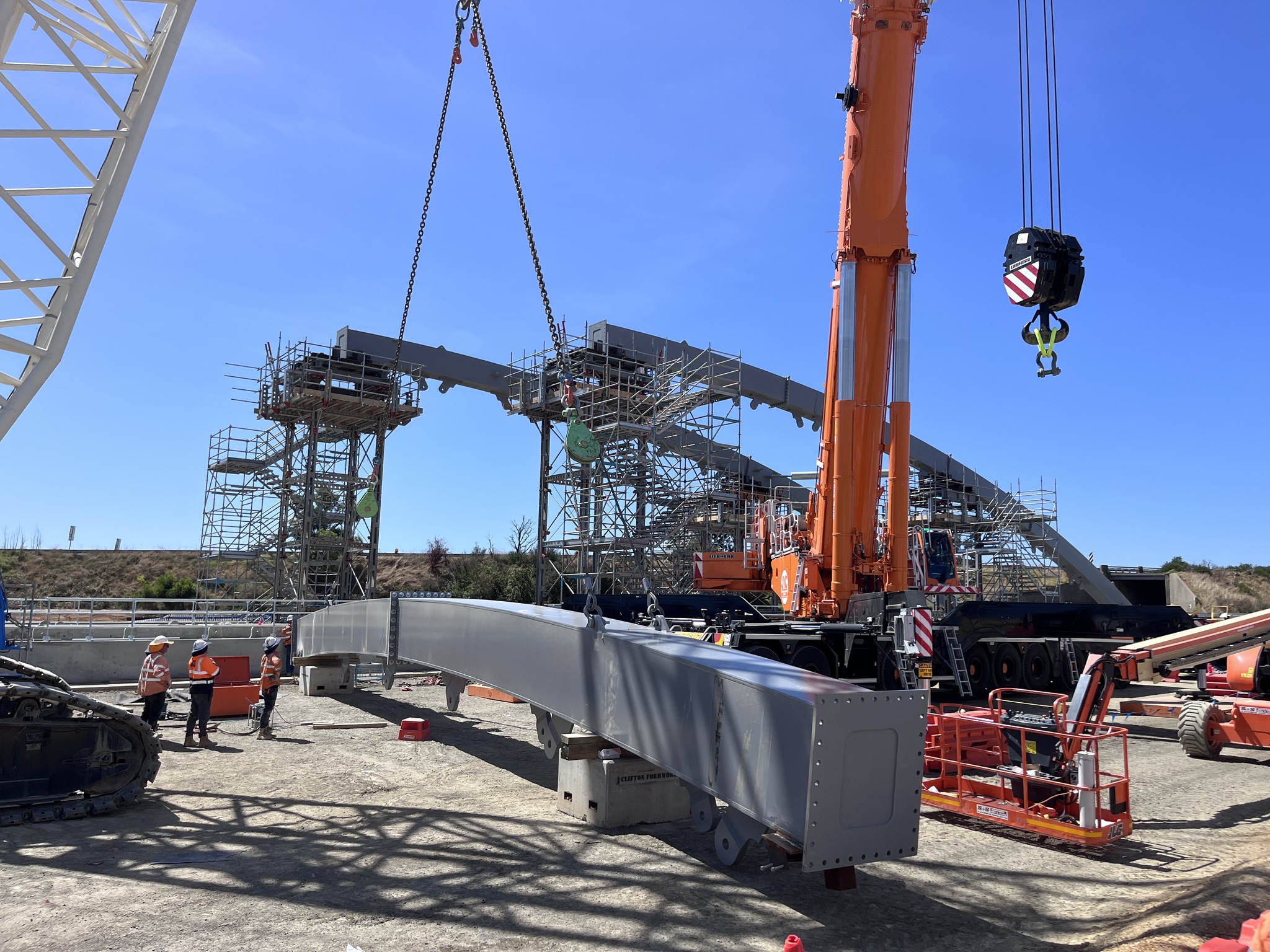
These photos caught my eye because the arch struck me as being very flat. And then I learned that this rather big bridge is just taking a railroad over a 4-lane highway.
Major Road Projects Victoria posted two photos with the comment:
Numbers in action 🔢
On the Princes Highway Upgrade between Traralgon and Sale, we’re installing an impressive-looking rail bridge for the Bairnsdale railway line in Kilmany. Here’s a snapshot:
- 16 arch segments  
- 450 tonnes of structural steel  
- 800 tonne mobile crane and 350 tonne crawler crane to handle the lifting 
- 1000 cubic metres of concrete poured once we’re finished
In layman’s terms, that’s a lot! It’s made out of z-grade steel, a low-sulfur steel with an ability to bend and warp, which is a good thing, meaning it can flex for heavy loads.
With new lanes now open between Sheepwash Creek and Flynn’s Creek Road and Velore and Templetons Road, we’re getting close to sliding in the bridge structure in the middle of the year.

[I wish the numbers included the length of the span.]

1

2

The arch looked flat because the photos are showing just the top part of it. The railroad overpass is so big because it is heavily skewed with the highway and they dug a deep valley for the road.
Eb Rabich commented on the above post

This view shows that they are building the new road alignment south of the existing road.
Street View, Jul 2022


Thursday, February 23, 2023

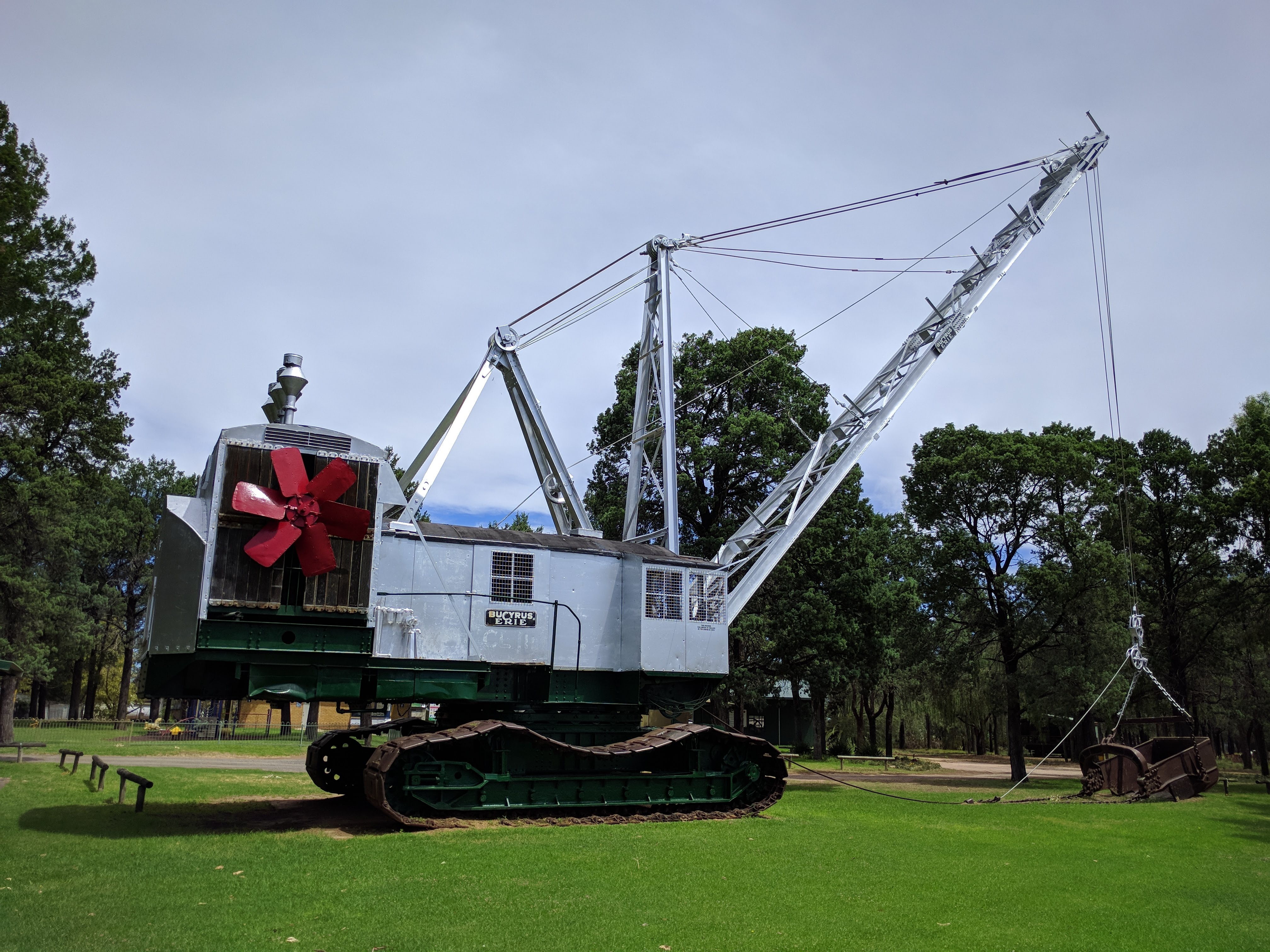
1945 Monighan 200-W draglines were initially built in Chicago, IL

I have not been able to determine the location of the Chicago factories for either Monighan or Page.

PAmining posted
In 1945, Bucyrus-Monighan introduced the 6 cubic yard, 200-W walking dragline. This turned out to be a popular model, as over 50 machines were produced before the Monighan Chicago plant closed in 1958. Production was then transferred to the South Milwaukee plant, but no more 200-Ws were built.
 This particular unit was owned by Jader Fuels of Illinois, and is seen here idled in 1982.
Trevor Harbor: Hi All there were 3 of these machines in NSW Australia . used through out the state to construct irrigation channels. they were last used around the early 60's . There is a Town named Coleambally in NSW and the local community in the 80's restored 1 and it runs every 2yrs they have a local fair with the main event being the starting of the bucyrus,
Franz Sontag: Trevor Harbor is steam or electric over diesel

Dennis DeBruler commented on Franz's comment
I presume the fan and radiator on the back are for a diesel engine.
 https://www.google.com/.../data=!3m7!1e1!3m5...

Andrew Davidson, Jan 2018

And here is a predecessor for the 200-W.
PAmining posted
Just 1 of 8 built between 1926 and 1932, the Bucyrus Monighan 4-W was one of the first machines to sport the improved Martinson walking mechanism!
The 4-W weighed in around 230 tons, and was supplied with bucket capacities ranging from 3-5 cubic yards, and boom lengths anywhere from 80-120 feet.  
Matt Scarff: 230 ton machine to do less work than a 50 ton hydraulic excavator today. Nonetheless, these were impressive beasts in their day.
Desmond Poole: What engine powered these big guys?
PAmining: Desmond Poole 3 cylinder Fairbanks Morse.
Dan Konz: Look through this link. There are two photos of one of these digging the Loup Power Canal in Nebraska during the 30's. https://loup.com/wp-content/uploads/85History_1.pdf  The bucket is still at the northeast corner of Lake North near columbus NE.

Draglines are another example of "necessity is the mother of invention." John W. Page invented the dragline in 1904 to help him with a contract for work on the Chicago Canal. In 1907, Page placed an order with Monighan's Machine Works of Chicago for hoisting machinery. In 1908, Monighan changed the name to Monighan Machine Co. and started building draglines himself. "In 1913, a Monighan engineer named Oscar Martinson invented the first walking mechanism for a dragline....This gave Monighan a significant advantage over other draglines and the company prospered.... So popular were these machines that the name Monighan became a generic term for dragline.....Bucyrus purchased a controlling interest and the joint company became known as Bucyrus-Monighan until the formal merger in 1946." Draglines were like tractors and generators in that there were several manufatures of them when they were new but now there are only two. [liquisearch]

EquipmentJournal
Bucyrus-Erie 200W dragline at the Canada Cement Company plant in 1958
Page Engineering Ltd. was also based in Chicago in 1910 when Bucyrus started "manufacturing medium to large-sized draglines for surface mining operations." Bucyrus aquired Monighan in the 1930s to acess its dragline walking system.

PAmining posted
This diesel powered Bucyrus-Monighan 9-W uncovered anthracite coal on the side of the mountain, overlooking the Susquehanna River in Luzerne County PA about 70 years ago! 
Tim James: Is this a walking drag line? Looks like it from the picture.
Glen Kayser: Tim James yes it's a walker, and was a very popular one. I believe the diesel models originally had low rpm motors like Cooper Bessemer or maybe even a Fairbanks Morse.
David Stigall: fairbanks morse locomotive engine . guess who had to take the oil plug.
Alan Engnes: Boy that sure brings back memories! Back in the 60's worked on two Monigan's near Pella,Iowa. Both were powered by FairBanks Morse engines, and Cat D315 powered generators . One Fairbanks blew up and replaced it with a 6-110 Detroit. Remember the noise it created was off the charts compared to the constant thumping of the Fairbanks. Both machines worked 20 hours a day, 6 days a week. Both machines were scraped mid/ late 70's. Thanks again for the memories.


Wednesday, February 22, 2023

1889 Old KY-84 White Mills Bridge over Nolin River in White Mills, KY

(Bridge Hunter; Historic Bridges; B&T; Satellite)

KY-84 was rerouted to a newer bridge in 1964.

Street View, Jun 2008, out-of-frame to the right is a 1-ton weight limit sign.

It is obviously pin connected.
Street View

White Mill dam:
Street View

1 of 3 photos posted by Bridges & Tunnels
In a time when truss bridges are becoming increasingly scarce, it is encouraging to observe the state of Kentucky's dedication to preserving some of its historic bridges when feasible. The White Mills Bridge, constructed in 1899 by the Champion Bridge Company, spans the Nolin River in White Mills and is a part of KY Route 1866. Prior to the completion of a new alignment around the town in 1964, the bridge served as a component of KY Route 84.
➤ Check out more photos of the White Mills Bridge at
 http://bridgestunnels.com/location/white-mills-bridge/ 

Dennis DeBruler commented on B&T's post
The original KY-84.
1949 Summit Quad @ 24,000

HistoricBridges mentions that it had revited steel bents.
Street View


Tuesday, February 21, 2023

1969 810mw Lower Monumental Lock and Dam on Snake River

(Satellite)

USACE
"The powerhouse has six 135,000-kilowatt units. Power generated during fiscal year 2017 was 2.67 billion kilowatt hours. This is a single-lift lock, 86 feet wide by 666 feet long, with a 100-foot vertical lift. About 2,903,090 tons of commodities passed through the navigation lock during fiscal year 2021. The cargo primarily consisted of grains, petroleum products, fertilizer and wood products. There are two fish ladders for migrating adult salmon and steelhead to use. Modifications to improve adult Pacific lamprey passage include installation of passage structures and metal plating to assist lamprey upstream. In 2007, a spillway weir was installed to improve conditions for juvenile fish passage at the dam. The 10-year average collection of outgoing juvenile salmon and steelhead for 2011 to 2020 at Lower Monumental was approximately 2.2 million fish with approximately 1.7 million of those transported via truck and barge below Bonneville Dam."
The eight Tainter gates are 50'W x 60'H. The peak discharge is 850kcfs.
The Kaplan turbine has six 26' blades and generates 212,400hp at 90rpm.

USACE-crso
"Lower Monumental Lock and Dam was the second of four dams constructed as part of the Lower Snake River Project, authorized in the Rivers and Harbors Act of 1945. Construction began in 1961, and three turbine units were operational in 1970. Three more units were operational in 1978. Lake Herbert G. West extends upstream of the dam for 28 miles to Little Goose Dam."
The hydraulic capacity is 130kcfs.

WallaWallaUSACE posted
On May 28, 1969, Unit #1 at Lower Monumental Lock and Dam - Walla Walla USACE  was put into operation. Today, there are six 135,000-kilowatt generators in the powerhouse. This is enough clean energy to power over 650,000 homes!
Larry Walker: Picture not accurate!
John Getz: Larry Walker it's a conceptual drawing from before the dam was built.

CapitalPress, U.S. Army Corps of Engineers (source)

Lower Monumental Lock and Dam - Walla Walla USACE posted

USACE-nwd
"It is 3,791 feet long, with an effective height of about 100 feet. The dam is a concrete gravity-type dam, with earthfill abutment embankments."

USACE-images

Vance Robbins, Jul 2021, cropped

Michael Larsen, Jun 2022
 
Andy Michel posted
Stuck in the lock at LoMo   Tri-City Herald    August 13th, 1979

Lower Monumental Lock and Dam - Walla Walla USACE posted two photos with the comment: "Lower Monumental Lock and Dam, 2002: Over two days during the winter of 2002, construction workers at Lower Monumental Dam poured about 2,200 cubic yards of concrete into two large holes in the dam’s stilling basin, an area in front of the dam used to dissipate the force of the water coming through the spillway gates. In the basin, bubble screens deterred fish from the project area and biologists monitored the water quality. Construction continued through mid-February as workers installed new spill deflectors to improve fish passage conditions."
1

2

oxboinc
During the Winter of 2010-11, the gate was replaced. It was fabricated and shipped on a barge as three sections.

USACE-20210201
[I don't know if this is the lock for this dam. If not, it is a similar lock.]
"he U.S. Army Corps of Engineers’ Portland and Walla Walla districts will close all Corps navigation locks on the Columbia and Snake rivers March 6 at 6 a.m[, 2021]. for regularly-scheduled annual inspections, preventative maintenance and repairs." A routine maintenance closure is two weeks.

union-bulletin, Seattle Times file photo by STEVE RINGMAN
The road across the dam was closed during May, 2022, to greese some trunnions that originally were designed to be unlubricated.
[USACE press release]

WallaWallaUSACE posted, May 18, 2022
Lower Monumental Dam reopens public dam crossing
Officials at Lower Monumental Lock and Dam have reopened dam crossings to the public after completing spillway gate repairs.
Read more: https://www.nww.usace.army.mil/Media/News-Releases/Article/3035449/22-032-lower-monumental-dam-reopens-public-dam-crossing/
Lower Monumental Lock and Dam - Walla Walla USACE shared

WallaWallaUSACE posted
LTC ShaiLin KingSlack, Commander of the Walla Walla District, and Tyler Hutton, Power Plant Mechanic Worker In Charge at Lower Monumental Lock and Dam, looking up at the sheave for Lower Monumental's vertical lift gate 1.
A sheave is a wheel that moves ropes through a pulley mechanism. This sheave is part of the mechanism that lifts the Lower Monumental navigation lock gate.
Fort Loudoun Lock shared
Another example of the tremendous scale & size of the equipment it takes to get the job done in many cases around the Corps. 

WallaWallaUSACE posted
“Empty Nav Lock at Lower Monumental during Fish Rescue,” by Denise Griffith. This photo captures a pause on a river highway more than a century in the making. Since the 1970s, the Lower Snake River dams have completed a 465‑mile inland waterway from Lewiston to the Pacific, allowing millions of tons of Northwest grain and goods to move safely and efficiently.
Investment in routine maintenance of our locks and dams allows towboats and barges to routinely transport commodities, linking inland communities to seaports, keeping thousands of trucks off regional highways.


Monday, February 20, 2023

1938 Vaal Dam in South Africa

(Satellite)

I don't normally do dams on other continents because the USA has more than I can cope with. But I don't normally see a dam spilling so much water that homes are being significantly flooded.

Storm Report SA posted nine photos with the comment: "Beautiful images taken by Rudi this morning of the Vaal Dam. The dam currently has 12 gates open."
[According to some of the comments, other parts of South Africa are in a drought.
And some comments confirm that this plant has no hydropower. Other comments say that is because most years they would not be able to generate power because of the need to conserve water.]
2

1

3

4

5

6

7

8

9

Robyn Bothma commented on the post
It's beautiful , until you see what it's doing to people's homes.
Juanita Botha: Robyn Bothma is this around the dam or lower down the river?

Gene Booysen responded to Juanita's question
This is lower down the river.


Is the fourth gate closed now because that spillway normally gets plenty of wear? 
Adele Duvenage, Nov 2022

If three more gates makes that kind of impact on the trees, I wonder what 12 gates is doing to the trees.
Nikesh M (nikkxs), Jan 2022

Even with eight gates open in Nov 2022, they were worried about downstream flooding.
ewn
[They must have just opened those two gates because the tumble bay is still rather dry.
I don't see gates showing above the dam, so are the gates partially open?]
"The Department of Water and Sanitation says it’s the first time in 21 years that eight Vaal Dam gates have been opened to assist with flood management....Nearby communities have been warned that the opening of the gate will cause heavy flooding."

We Are South Africans
Did you know?
The Vaal Dam has x60 crest gates (kruinsluise).
Normal flow on a normal day in the Vaal River passing Three Rivers is around 16 cumecs.
Yesterday, the Dept of Water Affairs announced, with huge fanfare, that they opened x2 of those gates. Current (29 Dec 2021) flow past Three Rivers is in the order of 300 cumecs.
But in February 1975 they pulled open all, yes all x60 of those x60 crest gates (see the picture).
And 4000 cumecs of water thundered past Three Rivers & Peacehaven, and overnight raised the normal water level by around 9.5 metres 
Leon Delport
Paul Sabatier: I was a Signaller in the army. We were deployed from Wits Command to Vereeniging to assist with the evacuation of the civilians. I plotted the high water mark each hour on the map. At one stage the water rose from ground level to the crossbar of the rugby posts in 2 hours.
[Are the gates all the way open? I don't see them above the dam.
I'm assuming that "cumecs" is cubic meters per sec. So 4000 is 141kcfs. To help put that in perspective, the design capacity of the original spillway for the Oroville Dam was 125kcfs.]

ruralexploration.co.za via citizen
Normally, people in this area have to conserve water because a full dam is the exception. The dam opened in 1938. The storage capacity was increased in 1956 by raising the concrete crest and adding the row of sluice gates. It was increased again in 1985 by adding taller sluice gates.
"The last time [as of Nov 2020] the dam reached 100% capacity was in January 2011, when 14 sluice gates had to be opened to release the water, which was flowing at 1 800m3/sec."
[But 1800cumecs is only 64kcfs. So the gates must have been just partially opened since now 12 gates are spilling 141kcfs.]

And they are worried that they may have to open more than 12 gates. [sabcnews]