 |
| MWRD posted The South Branch of the Chicago River looking north from an area near 14th Street on November 8, 1908. Dennis DeBruler: The best view I have seen so far of the two Rock Island grain elevators. |
 |
Geral Vilenski posted
The "Commerce of Cheboygan", a sailing vessel at a harbor in Chicago, 1900.
Aruro Gross commented on a post
It's also the building in the middle background of this pic on Shorpy, if you click on the full size image, you can read the "rock Island Elevator" lettering on the top of the building... https://www.shorpy.com/node/21281Hi Res [Iowa on the left and the two on the right are Rock Island.] Association for Great Lakes Maritime History posted An image from a dry plate negative of vessels and elevators on the Chicago River dated Sept. 1, 1900 (Image Source: Library of Congress – Detroit Publishing Co. Collection). An analysis of a high-resolution copy of the photograph shows vessel on the right to be the Commodore. The Commodore has the markings “New York Central & Hudson River R.R. Line” on its bow. Behind the steamer is a vessel docked alongside Grain Elevator B, while in the center of the image is the sailing ship Commerce of Cheboygan. The history of the ship (see below) would indicate that the photograph is circa 1901. [The description continues with a history of the ships.]Association for Great Lakes Maritime History posted again |
 |
| MWRD posted on Dec 31, 2022 A view of the South Branch of the Chicago River in an area north of 18th Street on July 11, 1900. Dennis DeBruler: The grain elevator with the Schlitz signage was the Iowa Elevator. The two elevators behind that one were Rock Island elevators. MWRD posted [The freight house on the right was the Erie's 14th Street Freight House.] |
 |
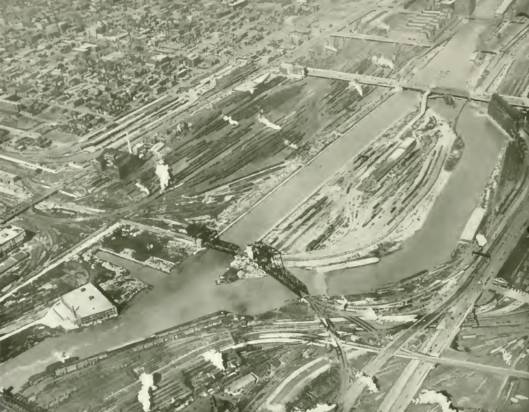
| MWRD posted on Jan 31, 2023 General view to north showing the South Branch of the Chicago River and the railroad yard at the bend north of 16th Street on June 24, 1920. Dennis DeBruler shared If you click the photo, you should be able to see the comment I added about the railroads and grain elevator. |
 |
| Dennis DeBruler commented on MWRD's Jan 31, 2023 post The grain elevator in the background was Rock Island "A". Rock Island "B" would be to the right of that elevator in this photo if it was still standing in 1920. The curved tracks with gondola cars were C&NW tracks. The white piles is where the Iowa Elevator used to stand. The tracks in the foreground are CB&Q, and the tracks in the left background were B&OCT. Given the slip in the lower-right corner, I think the above photo was taken from the Armour "F" elevator; and the Armour "E" elevator, which used to be north of the slip, has been torn down to make room for those newer tracks. Below is your photo from Dec 31, 2022, with the comment: "A view of the South Branch of the Chicago River in an area north of 18th Street on July 11, 1900." The elevator with the Schlitz sign was the Iowa. The one peaking out on the right was Rock Island "B," and the one in the left background was Rock Island "A." The big smokestack on the left was for Armour "E." |
 |
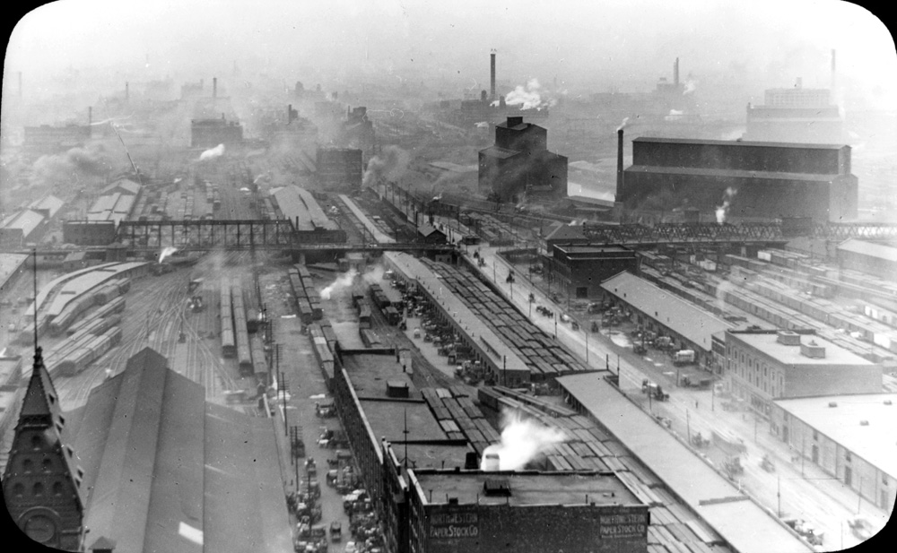
| pdf copy from 1915 Smoke Abatement Report |
City
This elevator was served by the Chicago & Northern Pacific (C&NP). By 1928, this route was owned by the B&OCT. Since 1901 is before the river was straightened, this elevator was next to the tracks that went north to the bridge to Grand Central Station. It is not clear if Soo/Wisconsin Central or Chicago Great Western or both served this elevator. Both of those railroads used this B&OCT route to access Grand Central Station.
 |
| 1901 Sanborn Sanborn fire insurance map provided courtesy of the Map Library at the University of Illinois at Urbana-Champaign. |
 |
| 1901 Sanborn Sanborn fire insurance map provided courtesy of the Map Library at the University of Illinois at Urbana-Champaign. |
Iowa
Some maps indicate this elevator was served by the B&OCT/C&NP. Other maps imply it was served by the C&NW. Actually, it may have been C&NP on the north side and C&NW on the south side.
 |
| 1901 Sanborn Sanborn fire insurance map provided courtesy of the Map Library at the University of Illinois at Urbana-Champaign. |
 |
| 1901 Sanborn Sanborn fire insurance map provided courtesy of the Map Library at the University of Illinois at Urbana-Champaign. |
 |
| pdf copy from 1915 Smoke Abatement Report |
 |
| 1910 Map |
A comment by Charles Vic on a post explains how C&NW had tracks to the Iowa elevator. Specifically, they used to own all of this land but sold most of it to CB&Q!
The wye at "Harlem" on the Galena & Chicago Union was not built to reach the cemeteries....</update>
The St. Charles & Mississippi Air Line Railroad (CStC&MAL) organized in 1850 to link Chicago with the Mississippi River. There was some grading carried out to St. Charles and construction of the Fox River Bridge was started, but the only track laid stopped short of the east bank of the Des Plaines River (blocked by the G&CU owning the timber and gravel lands that later became Haas Park and still later the cemeteries. The line (on the alignment of the CGW and CA&E) was bought at bankruptcy by the G&CU and they promptly built a connector (hence the wye) from Harlem to the CStC&MAL track. This "South Branch" of the G&CU allowed them to route most of the CB&Q traffic off their main line and in addition they picked up the very valuable properties in the city from the Chicago River west to Western Avenue along 16th Street. They sold off some of the property to the CB&Q and other railroads but the Western Avenue property became the "Potato Yard" and later Global 1. After the CB&Q built its own line into Chicago from Aurora the line was abandoned west of Western Avenue and a connector was made up to the West Line at Kinzie Street. The "St.Charles Air Line" that exists today was originally viewed as an extension of that line even though the official history of the C&NW and St. Charles Air Line do not mention the fact. The tail of the wye at one point was connected to the Waldheim Railroad which had been separately incorporated and also had been connected to a steam dummy line and the Chicago & Northern Pacific Air Line. G&CU shops at the wye became a car shops in later years.
 |
| Mike Savad safe_image for City - Chicago IL - Drink Schlitz 1900 Hand colored by me This is the Iowa grain elevator, built in 1880, and served the C&W railroad. The way it works goes like this, a boxcar full of grain would be moved inside the building. They would dump the cars into floor hoppers, and then that would be moved to the top of the building using automation. From there it would then fill ships outside. There was a lot of dust in the air, bad for the lungs, worse for the building, as explosions were a real threat. And was a threat for a long time after. On the right, the ship there is the Commodore. Named after "Commodore" Cornelius Vanderbilt, as it as one of their ships. It was considered the largest cargo ship on the great lakes. The sign is actually pretty interesting, its huge. They don't allow that now. in 1906 they passed a new rule that said you can't have building sized signs. They had to be smaller, though they didn't say why (probably because it wasn't fair to others). This building was built before then, so it didn't have to follow the rule. The schlitz beer company was founded in 1849, but went defunct in 1999. It's not known if the grain in that building became beer. If you look very carefully just next to the yellow boat, there is a pointy reddish building. That's Dearborn station with its iconic roof. This will help you center yourself on the map. |
 |
| David Daruska commented on Mike's post Sanborn Fire Map of the area this photo was taken. |
 |
| David Daruska commented on Mike's post Close up of the Iowa Elevator. |
Rock Island A and B
 |
| Noach Hoffman posted "Chicago Grain Elevator" photographer unknown. 1890 Smithsonian American Art Museum. Dennis DeBruler: I think we are looking at Rock Island A and B and the 12th Street Bridge. |
 |
| 1901 Sanborn Sanborn fire insurance map provided courtesy of the Map Library at the University of Illinois at Urbana-Champaign. |
 |
| 1901 Sanborn Sanborn fire insurance map provided courtesy of the Map Library at the University of Illinois at Urbana-Champaign. |
 |
| 1901 Sanborn Sanborn fire insurance map provided courtesy of the Map Library at the University of Illinois at Urbana-Champaign. |
 |
| 1901 Sanborn Sanborn fire insurance map provided courtesy of the Map Library at the University of Illinois at Urbana-Champaign. |
 |
| 1901 Sanborn Sanborn fire insurance map provided courtesy of the Map Library at the University of Illinois at Urbana-Champaign. |
 |
| MWRD posted The South Branch of the Chicago River on July 26, 1910, looking north towards an area near 12th Street (now Roosevelt Road), taken to document the dock conditions on the west side of the river. Dennis DeBruler shared This was taken before the river was straightened. The grain elevator is Rock Island "A". Rock Island had another large gain elevator, "B", that would have been just out-of-frame to the right (South) side. The low building is labelled by Sanborn as "C.R.I.P.R.R. Out Freight Dock House." The yard on the left was Pennsy. Note that 12 Street has a swing bridge over the river and a truss viaduct over the railroad yards. |
 |
| Dennis DeBruler commented on his share https://digital.library.illinois.edu/.../ca3321d0-c457... |
 | |
|
 |
| The fourth image posted by Dave Durham, cropped |
When the project to straighten the South Branch started, both of the Rock Island elevators were standing on the right side of this photo.
 |
| Chicago and the World's Fair, 1933, p. 116, from Internet Archive (source) |

 |
| DeBruler |
 |
| Frederick Buike posted |
 |
| Dennis DeBruler commented on Federick's post 12th Street is now Roosevelt Road in Chicago. This photo was taken before the river was straightened. That is Rock Island B on the left (East) and Iowa on the right. Rock Island A is out-of-frame on the left and City is out-of-frame on the right. |
 |
Evan Stair sharedDearborn Street Station?Railroad yards south of the Loop Matt McClure: Yes, and Dearborn Tower pre-cupola fire of 1922.1912 University of Chicago Library, Special Collections Research Center Dennis DeBruler: This is just the second photo I have seen that has both of Rock Island's grain elevators. And it shows the area before they tore it up to straighten the river. https://www.instagram.com/p/qkoN7HKS8o/?taken-by=vintagetribune |
No comments:
Post a Comment