(
Bridge Hunter;
Chicagology; It was
between Taylor Street and Roosevelt Road.)
This bridge was controlled by the
Polk Street Tower.
This bridge was used by the Chicago Terminal Transfer Railway to access
Grand Central Station. The CCT was a corporate predecessor of the B&OCT.
 |
MWRD shared
Jeff Nichols photo
Chicago Terminal Transfer Railway Company Bridge over Chicago River (between Taylor and Roosevelt), 1911. Chicago History Museum, DN-0056531
[Roosevelt Bridge must still be a swing bridge because we see the gaurd for the pivot pier in the foreground.] |
 |
Association for Great Lakes Maritime History posted
An image from a dry plate negative of an excursion steamer passing under the 12th Street Bascule Bridge in Chicago, Ill., circa 1900-1910 (Image Source: Library of Congress – Detroit Publishing Co. Collection). An analysis of a high-resolution copy of the photograph shows the steamer to the I.M. Weston. The lettering on its bow reads “Daily Excursions to Drainage Canal – Leaves Clark St. Bridge 10 A.M.” Based on the vessel’s history (see below), the image is circa 1900-1902. [The description continues with a history of the 97' vessel.] |
I learned that the bascule bridges replaced a swing bridge.
 |
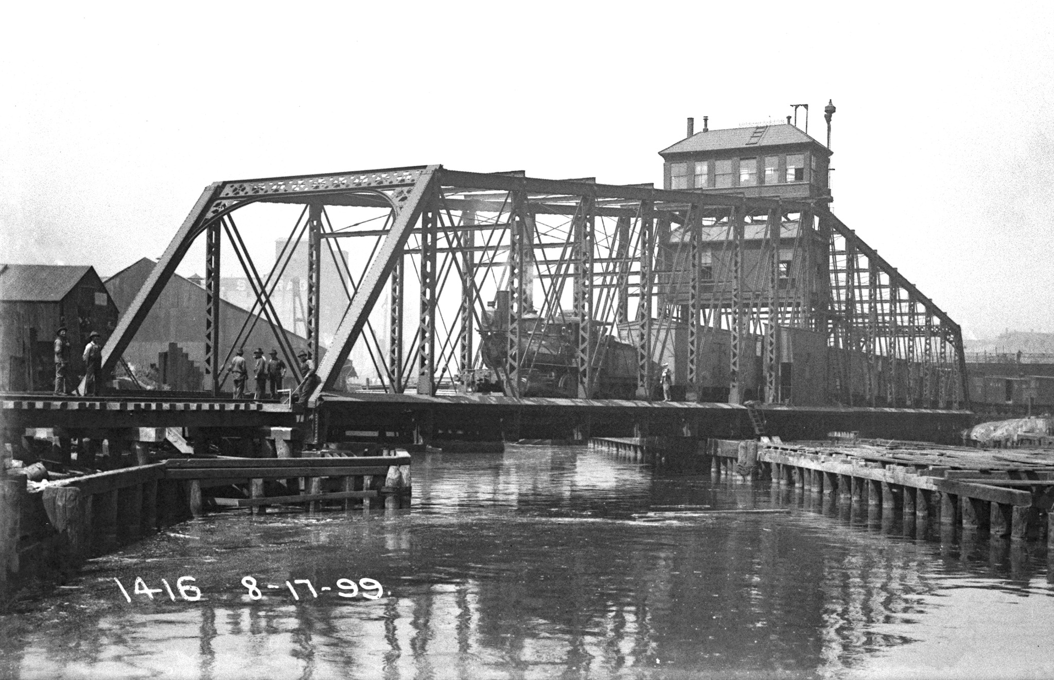
MWRD posted on Mar 5, 2023
A locomotive pulls rail cars on the Chicago Terminal Transfer Railroad Bridge over the South Branch of the Chicago River north of Eighth Street on August 17, 1899.
Greg Burnet shared
MWRD posted
A locomotive pulls rail cars on the Chicago Terminal Transfer Railroad Bridge over the South Branch of the Chicago River north of Eighth Street on August 17, 1899.
Greg Burnet shared
Timothy Clement: Was this bridge replaced? |
 |
David Daruszka responded to Timothy's comment
Replaced by a Schurzer Rolling Lift Bridge. |
 |
Bob Lalich commented on the Mar 5 post
This bridge and the rolling lift bridges that replaced it were located just south of Taylor St. The view is south from Taylor St. The bridge is circled in red in this map. |
In this photo we can see the new bascule bridge in front of the old swing bridge.
 |
MWRD posted on Nov 21, 2022
A view north showing the Chicago Terminal Transfer Railroad bridge over the South Branch of the Chicago River between Harrison Street and Roosevelt Road. The exact date is unknown. |
This bridge was rare because it is a double leaf railroad Scherzer rolling lift bridge. The above view is looking north. The following map excerpt indicates it was between Roosevelt (12th) and Taylor. (The two roundhouses west of the river near Roosevelt are interesting.)
I include these excerpts from
an 1897 map to provide context for how the river ran before it was straightened. Note that Lake Park has been developed (west of the IC tracks), but Grant Park has not been started (east of the IC tracks).
 |
| a |
 |
| b |
Given the grain elevators, this view must be looking south. This is the only view I remember seeing that shows the river before it was straightened.
 |
David Daruszka commented on a posting
Postcard of the bridge. |
 |
Martin G. Sorenson posted
Chicago circa 1900. "12th Street Bascule Bridge." Dinosaurs of the ... top (north) bridge is no longer in use - it served the old Grand Central Station (B&O and others) at Wells and Harrison until the late 50s.
David Daruszka The boat is a tour boat of the recently completed "drainage canal". The Sanitary and Ship Canal was an engineering marvel, and the techniques used in it's construction were replicated at the Panama Canal.
[This photo was taken from 12th Street (Roosevelt Blvd.) Bridge, not of the 12th Street Bridge. The bridge was replaced by the Strauss bridge near 16th Street when the river was straightened. The bridge in the background was Taylor Street. ]
Mike Savad posted a watercolor of this photo. |
 |
Kristopher Isaac Barrington posted
Twelfth street Bascule Bridge in Chicago |
These Scherzer rolling lift bridges replaced swing bridges.
To make room to build the rolling bridge, new approaches were built and the swing span was moved 53' upstream in the August 1899. ("Upstream" is technically not correct because the river wasn't actually reversed until 1900. But the rolling bridges were built by the Sanitary District of Chicago in part to provide the 300,000 cubic feet per minute flow needed to flush the Chicago River down the new canal. So Railway Age uses terminology that assumes the project is complete.)
It needed to move 53' to have enough room to swing open without hitting the new bridge.
 |
Public Domain photo from Bridge Hunter, cropped
From "Scherzer rolling lift bridges" by the Scherzer Rolling Lift Bridge Company, Chicago. Published 1908 |
 |
Public Domain photo from Bridge Hunter, cropped
From "Scherzer rolling lift bridges" by the Scherzer Rolling Lift Bridge Company, Chicago. Published 1908 |
 |
MWRD posted
A view to the north showing the Chicago Terminal Transfer railroad bridge over the South Branch of the Chicago River on April 9, 1920.
Bob Lalich: By 1920, Chicago Terminal Transfer RR had been reorganized into the B&O Chicago Terminal RR. |
 |
Public Domain photo from Bridge Hunter, cropped
From "Scherzer rolling lift bridges" by the Scherzer Rolling Lift Bridge Company, Chicago. Published 1908 |
 |
Public Domain, eBook, p 609, looking southwest
[Note the swing span Roosevelt Bridge in the background.] |
To move it upstream, they built a wooden sliding way similar to what is used to launch ships. In the following photo you can see the new wood structure under the right (upstream) side of the opened span.
 |
| Public Domain, eBook, p 608, looking norhtwest |
This is a closeup of the sliding way. They used over 90 jacks crowded under the center part of the span to raise it 26" so that they could build a cradle to slide on the way. They smeared 500 pounds of beef tallow over the ways to lubricate them. After the span was lowered onto the cradle, they used the hoisting engines of two piledrivers anchored at the upstream end of the span. "The jacking-up was begun on Sunday, August 13, and the span was turned into position for traffic on its new site on Thursday, work having been delayed 24 hours by the strike of the Iron Workers' Union Monday evening." [eBook, pp 608-609]
Daniel O'Hearn
posted the question of where did the Rock Island service the locomotives for their passenger trains. That answer was the
47th Street Yard. A question concerning access to Grand Central Station came up in the comments. Thus David added two comments. The first one duplicates an above image, but the second one is a new view.
 |
| David Daruszka commented on Dave's post |
MWRD
posted two photos with the comment:
The steamship Eber Ward after it collided with the Chicago Terminal Railroad Bridge on December 7, 1908. The collision caused damage to both the ship and the bridge and was a bad omen for the ship as it sank a few months later in April 1909 after suffering damage from icy waters in the Straits of Mackinac.
Metropolitan Water Reclamation District of Greater Chicago The ship is still submerged:
https://www.shipwreckexplorers.com/steamer-eber-ward/
https://www.shipwreckexplorers.com/gallery/index.php...
Jeremy Farmer I found these clippings about it
http://images.maritimehistoryofthegreatlakes.ca/.../data...Jeremy Farmer Where are these images sourced from? Your own archive?
Metropolitan Water Reclamation District of Greater Chicago The historical photos we have been posting come from a vast collection of glass plate negatives created between 1889 and the mid-1900s. Digital imaging technology has improved greatly since the first plates were originally scanned about ten years ago, and we have recently entered into an Intergovernmental Agreement with the Illinois State Archives to rescan and catalog all 20,000 glass plates in our collection.
Staff from the MWRD and Illinois State Archives are working together with volunteers (including former MWRD Executive Director Richard Lanyon) to carefully scan each plate and to research and describe what each image depicts. The resulting digital files will be available online and by request from the MWRD and Illinois State Archives.
These amazing images are a valuable resource for the MWRD, wastewater and stormwater industry professionals, educators and students, historians, and all citizens. They provide an unparalleled glimpse of our great city and state during the early years of environmental protection and wastewater management. We are excited to share them with you.
Greg Burnet
shared
 |
1
MWRD posted
The steamship Eber Ward after it collided with the Chicago Terminal Railroad Bridge, viewed from the west bank of the Chicago River, on December 7, 1908. The collision was a bad omen for the ship as it sank a few months later in the Straits of Mackinac after a collision with floating ice.
Richard Fiedler shared
Greg Burnet shared |
 |
| 2 |
 |
William Lafferty commented on MWRD's post
The collision halted vessel traffic on the south branch and much rail traffic for two days, trapping over thirty vessels on the river. Damage amounted to over $25000, a considerable some in those days. The Eber Ward, named for the former lake captain who became an early millionaire through his iron ore and railway investments, among others, reposes in 145 feet of water in the Straits, a popular dive. Here is a Chris Roxburgh photograph of it taken a few years ago showing its other end. |
Brendon Baillod
posted three images with the comment:
This Chicago stereoview represents a distinct departure from the stereos I usually post. Although it shows a Great Lakes schooner, it represents a much later and more common photographic medium.
This card is an example of the mass produced lithograph stereoviews made after 1900 by Keystone, Underwood, H.C. White and others. These cards used stock images and were sold by the thousands in the Sears and Wards catalogs, mostly to older people who were nostalgic about the "golden days" of stereoviews in the 1860s and 70s. The cards are usually on darker gray stock and are deeply curved, often showing scenes from Europe or Asia. Unlike the classic locally made stereos of the 1860s and 70s, which were hand-mounted albumin prints made by the photographer, the post 1900 cards are machine mounted lithograph images.
Stereos of this era are less historically important and consequently, less valuable. Still, the post 1900 cards sometimes contain lightly circulated views such as this one of the schooner W.O. Goodman passing under the bascule bridges on the Chicago River.
This is a nice view of the seldom-photographed Goodman. Built in 1882 at Manitowoc by Rand and Burger, she sailed in the lumber trade out of Chicago for most of her career before going to the coast in 1906, sailing out of Boston. Her documents were surrendered there in 1917 when she was presumably abandoned.
Brendon Baillod
shared Dennis DeBruler
shared with the comment: "This is a new view of the Chicago & Northern Pacific (later B&OCT) double Scherzer bridge that provided access to the Grand Central Station. Lumber, along with grain and meat, were the commodities that made Chicago in the mid-1800s. South of 12th Street (Roosevelt) were several large grain elevators, and south of 16th Street along the north shore of the South Branch were several lumber yards. Thus today's street name of Lumber Street."
 |
| 1 |
 |
| 2 |
 |
| 3 |
 |
Dennis DeBruler commented on his post
This 1897 map shows the original access route to Grand Central Station that used this bridge. |
 |
Dennis DeBruler commented on his post
The key for the 1897 map. |


 This is a closeup of the sliding way. They used over 90 jacks crowded under the center part of the span to raise it 26" so that they could build a cradle to slide on the way. They smeared 500 pounds of beef tallow over the ways to lubricate them. After the span was lowered onto the cradle, they used the hoisting engines of two piledrivers anchored at the upstream end of the span. "The jacking-up was begun on Sunday, August 13, and the span was turned into position for traffic on its new site on Thursday, work having been delayed 24 hours by the strike of the Iron Workers' Union Monday evening." [eBook, pp 608-609]


No comments:
Post a Comment