Sunday, October 23, 2022

The Kingsbury Thrust Bearing

Hydropower plants pioneered big generators. The first plants used units with horizontal shafts. Here are some examples.

1907 MWRD Lockport via Dennis DeBruler

1907 Croton via Dennis DeBruler
 
1909 Dam #4 via Dennis DeBruler

1911 or earlier via Dennis DeBruler

1911 Marseilles via Dennis DeBruler

1913 Healey Falls via Dennis DeBruler

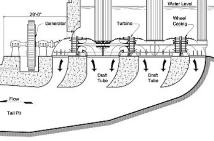
In 1896, Professor Kingsbury invented a thrust bearing that required just one thrust collar on the shaft. [26:57 video @ 7:29] He was researching oil lubrication, and he figured out how to use oil under high pressure to support high forces between the single shaft collar and the bearing. This allowed a bearing at the bottom of a vertical shaft to support the tremendous weight of a generator and its turbine. While watching the video, I realized that the waterwheels in the Lockport and Croton powerhouses had balanced axial forces. Specifically, the water comes out of both sides of each waterwheel. 

The ASME has some different dates: "His first experimental bearing was tested in 1904. He filed for a patent in 1907, and it was granted in 1910." The first Kingsbury bearing in hydroelectric service was installed in the Holtwood Hydro Plant in 1912.
1912 Holtwood via Dennis DeBruler

The 1913 Keokuk Powerhouse used roller bearings in half the units and Kingsbury Thrust Bearings in the other half. The bearings were four times larger than the prior art, so they were effectively experimenting with thrust bearings. 
1913 Keokuk via Dennis DeBruler

This is the post that motivated me to research thrust bearings.
Pacific Northwest Hydroelectric Power Plant Operators posted @ 0:03
For everyone out there like me that wondered when the Thrust Bearing Oil Pump (High Lift Pump) pressure relief valve would ever operate, the answer is every single time the pump initially starts. Pretty cool to be able to witness this with the thrust bearing tub completely removed.
[Note the "fountain" of oil near the middle of the screenshot.
We can see that each shoe has a pipe that feeds it oil.]

Shove the slider to about 0:12 seconds and listen to the shoes drop.
Pacific Northwest Hydroelectric Power Plant Operators posted
Once in a lifetime opportunity to see the thrust bearing shoe stripper bolts doing their job during a unit brake jacking evolution.
Neil Jacobson: Amazing how much suction power there is between two metals with a fluid between them.

Another video with the comment: "Thrust Bearing Shoe Stripping."
Neil Jacobson: If I remember right there is a permissive limit switch that has to be closed to allow start up.
Andy Michel: Neil Jacobson Yes, based on pressure.

The above referenced video (26:57) made me realize that just because a shaft is horizontal does not mean there are no axial forces. That was when I checked the diagrams of Lockport and Croton and realized that the water wheels have just radial forces because the axial forces are balanced. But steam driven turbines would have a massive amount of axial force because of the steam pushing against all of those blades. That is why this turbine has five thrust collars. It is from the early 1900s and high-performance, single-collar thrust bearings have yet to be invented.
Dennis DeBruler


Saturday, October 22, 2022

Coors Brewery in Golden, CO

(3D Satellite)

Historic Denver posted
Coors Brewery in Golden, CO. (1910)
[The Banquet brand is still brewed in just Golden and is shipped asl the way to Maine. It is brewed with “pure Rocky Mountain spring water” that comes from eight wells on the property. They purchase Clear Creek Water from the City of Golden, which owns the water rights.]
Will Fleckenstein shared
 
Kevin McCarthy commented on the post
Had this photo in my files for a while. It's the same time frame.

Dennis DeBruler commented on the Will's share
It has grown quite a bit since then.
 https://www.google.com/.../data=!3m1!1e3!4m12!1m6!3m5...
Will Fleckenstein: Dennis DeBruler the smell is probably the same.

I toured it many years ago. Back then they did not market Coors in the east, including Chicago. Thus Coors appealed to some here because it was hard to get. Once they started marketing across the USA, I think it lost much of its appeal.

Tom Winderknecht, Sep 2012


Friday, October 21, 2022

1918,1978-2008 Replaced/IN-327 Bridge over NS/NYC in Corunna, IN and AFT Mural

1918: (Bridge Hunter; Historic Bridges)
2008: (Satellite)

AFT = American Freedom Train

InDOT via HistoricBridges

This bridge has been on my mind since I started writing this blog.  Seeing it depicted in this mural motivated me to pursue it.
1 of 10 photos posted by Visit DeKalb County
[The artist is standing in front of his mural of the American Freedom Train.]
It was a windy and chilly day last Saturday, but everyone involved with the Corunna Volunteer Fire Department Mural all gathered to admire the finished art piece off Highway 6 in Corunna, Indiana. Ricco Diamante, the mural artist, met with everyone to discuss the finished piece, the process and how much thermal underwear it took when being on top of a scissor lift off the highway at night. Answer: a lot!
Finished Mural on 10-11-2022 on
Corunna Volunteer Fire Department
1111 US-6, Corunna, IN 46730
"This mural is a tribute to the town’s celebration of USA’s 200th anniversary, which took place in 1976. At that time the Freedom Train passed through the center of town. The Corunna bridge was later uniquely painted with a patriotic red, white, and blue theme. Corunna’s history is centered around the Norfolk and Southern rail line and the historic highway U.S. 6, once known as the longest highway in the country.
Railroads and highways connect communities both economically and culturally. Bridges in art symbolizes union, progress, connections, and stability. I decided to paint the Freedom train in this Corunna Bridge Mural because more than 7 million Americans visited the train during its 48 state tour, while millions more stood trackside to see it go by. The train itself consisted of 10 display cars. They carried more than 500 treasures of Americana, including George Washington's copy of the Constitution, the original Louisiana Purchase, Judy Garland's dress from The Wizard of Oz, Joe Frazier's boxing trunks, Martin Luther King Jr.'s pulpit and robes, replicas of Jesse Owens' four Olympic gold medals, a pair of Wilt Chamberlain's basketball shoes, and a rock from the Moon.
Thank you to the Corunna mural committee. The Corunna Town Board, Corunna Fire Department, The Dekalb County Visitors Bureau. MacAllister Rentals, and Sherwin-Williams Paint." - Ricco Diamante
FWRHS shared
Cody Lewis Wittenmyer V: It is absolutely beautiful! That being said, the painters used the wrong American Freedom Train locomotive that went through the area. The one that went through was Reading Railroad 2101, a 4-8-4 T1 type. It now resides at the Baltimore and Ohio Railroad Museum in Baltimore, Maryland.

It would be hard for westbound travellers on US-6 to miss the mural.
Street View

When I was a kid, my family used to go up IN-327 most Saturdays to visit my grandparents. I remember this bridge because I think it was "paved" with wood planks back then (1950s and 60s). And the approaches had a sharp angle. Furthermore, the roadbed had the same sharp bend between the approach spans and the main span that the sidewalks still had when Nathan Holth took this photo. The front of the the car would jerk downwards as it drove onto the main span and then again as it drove off. Riding along in the backseat, that bridge would creep me out every time we crossed it because of the rattling wood planks and the car jerking downwards. It struck me when I was older that a long straight truck might hit the bridge when their front wheels drop down.
Photo #14

After I-69 was built, we quit using that part of IN-327. Thus I never saw it after the 1978 rehabilitation. I see from this photo that they rounded off the junction between the approach span and the main span. This photo also shows what Nathan called the "Most Unique Paint Job." 
BridgeHunter

I see that the 2008 bridge has approaches that are a whole block long so that the curve at the top of the approaches is much more gentle. I  presume that 18-wheelers can safely go over this bridge.
Street View

Since the bridge wasn't replaced until the 21st Century, we can use Google Earth to get a "before" image. One can see that the approaches were so short they barely went past the edges of the railroad cut. (I also captured that this town uses lagoons for water reclamation. Fortunately, a contemporary satellite image shows that they are now keeping the algae off the ponds.)
Google Earth, Jul 2006

I also included the road in the upper-left corner because that was something else I remembered about these trips. Note that IN-327 north of Corunna ends at US-6. You had to turn West and go just a few blocks and then turn North again. I happened to notice that IN-327 has another "jog" just south of Helmer. I wondered why this road had these sharp 90-degree turns that really slow you down. I finally learned that it was because the earth is a sphere. A township is supposed to be six miles on each side. Because of the curvature of the earth, the top part of a township is shorter than the bottom part. So the surveor moves the side of the next township up so that the width is back to six miles. And IN-327 was built along the township boundaries in this area. Zooming out the satellite map, I see IN-327 also has a jog south of Corunna so that it is further west than Garrett, IN.
Satellite


The railroad through Corunna was the NYC mainline between Chicago and New York. This location used to have track pans for the NYC. [Eric Zerkle comment on a post. That comment seems to have been deleted. But not because it wasn't true. A comment by wabash2800 in trains confirms there were track pans near here. And wabash2800 in trainorders states that they were about a mile west of the bridge. (Trainorders also has a photo of the Purina Chow feedmill that used to be west of the bridge.)]
Dennis DeBruler

In fact, while confirming Eric's comment, I found this photo.
ogrforum
A little more information on the history and operation of track pans can be found here... www.jimquest.com/writ/trains/pans/Track_Pans.pdf   
"Photo of Track Pans on the former NYC at Corunna, Indiana taken just after they were installed in 1906/7."

Because of the shadow, we can clearly see where the grain elevator was. The building west of it was the depot.
EarthExplorer: Nov 28, 1951 @ 28,400, AR1PJ0000040151

Thursday, October 20, 2022

Coraopolis Bridges over Back Channel (Ohio River) at Neville Island

1893: ("The previous structure, constructed in 1893 to carry a trolley line, was situated on a slight skew from the present bridge alignment. It consisted of three 224' camelback truss spans and five truss and girder spans, varying from 49' to 82' long." [HAER-data])
1927, spans were built in 1892: (Bridge Hunter; no Historic Bridges; HAER)
1995: (pghbridges; Satellite) 

The other road bridge to the island is Fleming Park, which is near the other end of the island.

The 6th Street Bridge was one of the bridges that the Secretary of War declared was a navigation hazard. It was too low for steamboats with their smokestacks folded down during some parts of the year. The 1892 bowstring truss bridge, which was designed by Theodore Cooper, still had a lot of life left in it. So the county moved those truss spans 12 miles down the Allegheny and Ohio Rivers to this location in 1927 to make way for today's suspension bridge at 6th Street. 

HAER PA,2-CORA,1--2, cropped
2. West elevation, showing entire structure: Pennsylvania truss main spans and pony truss approach spans - Coraopolis Bridge, Spanning Ohio River back channel at Ferree Street & Grand Avenue, Coraopolis, Allegheny County, PA

HAER PA,2-CORA,1--1
1. Distant view from southwest, showing environment

HAER PA,2-CORA,1--7
7. East elevation, oblique view from southeast

The Coraopolis Bridge was listed on the National Register of Historic Places on January 7, 1986. The bridge derives historic significance from its age, its unique history at two different sites, and from its association with a nationally significant engineer, Theodore Cooper. Constructed in 1892, the through truss spans reflect an early largescale application of steel in the fabrication of heavy truss bridges. The 1927 relocation provides an excellent case study in the versatility of the metal truss bridge, exemplifying the adaptability of this structure type, a feature which was highly touted by advocates of this design in the last quarter of the nineteenth century. The through truss bridge has been identified as the only surviving structure entirely designed by Theodore Cooper (1839-1919), who achieved a national reputation for railroad and highway bridge design.
[HAER-data, this source includes a biography of Theodore Cooper. I recognize the name because he was the engineer responsible for the Quebec Bridge that collapsed during construction.]
The spans were jacked down 18' in 15" increments. It took 14 hours to lower a span. In order to fit under a couple of bridges that were on the route, they had to remove some of the top cords. Since the removal of those cords removed the strength of the truss, four barges were used to provide support under each of its sixteen panels in a truss. At the new location, the spans were jacked up 32'. The move cost $316,000 and took 140 days. The total cost was $800,000. Moving the spans was estimated to save $300,000. At the time of replacement in 1995, the bridge had a weight limit of 3 tons and was closed when the temperature was below 30 degrees Fahrenheit. [HAER-data, p13-17]

Randy McCrory posted, cropped
Some posted recently about a bridge being moved from Pittsburgh to Neville Island. Here is an image of the bridge being moved.

Beaver County,Penna Historic Exploration added
Neighbors To Our East:
Coraopolis-Neville Island Bridge
Under Construction
Allegheny County,Penna
1927
Albert Wickline: The one pictured here is no longer there but replaced by the old bridge from Pittsburgh.
Dave Milcoff: This after being floated down river from 6th Street in Pittsburgh where it was replaced by the current “three sisters” variety 6th Street Bridge, aka Roberto Clemente Bridge. Fascinating stuff! I recall crossing this bridge at the very end of its existence - when on cold days, it would be completely shut down, and when open it would have a 3 ton limit with a height barrier installed and a 10 mile an hour speed limit. Meanwhile, it carried streetcars into the 1950’s…
Rick Matzko: Look at the old bridge to its left.

Jackson-Township historical preservation posted
Looking from Neville Island, Allegheny County, towards the Coraopolis Bridge on March 3, 1927.
John Qualley: Five minutes before they moved the sixth Street bridge down the river to replace this

The 1995 bridge is a UCEB (Ugly Concrete Eyesore Bridge), so Bridge Hunter doesn't have a post about it. But the 1927 post does include this photo of the replacement so that I can determine the label should be "GirderSteel" instead of "GirderConcrete."
Photo by Todd Wilson via BridgeHunter


CTA Oakton (Skokie) Heavy Maintenance Shop

(Satellite)

Evan Stair shared
CTA Shop - 1950
Mike Fabian works on wheels at the CTA shop on Oakton Street in Skokie in 1950. Photo by Russell V. Hamm
https://www.instagram.com/p/yvvOhVKS-j/

Jonathan Hartsaw, Oct 2016

Elmer Costabile, Aug 2017

I copied the following from O'Brien WRP. This is how I first learned about this repair shop.

Satellite
When I discovered the name had been changed to Terrence J. O'Brian, I realized this is the plant that recently added ultraviolet lights to kill the bacteria in the effluent. Adding the disinfection equipment caused the collapse of the CTA Yellow Line embankment that runs along the north side of the WTP. In fact, the current satellite image shows the damage and some of the embankment shoring that was added.

A Chicago Tribune article (CT) indicates the accident happened May 17, 2015.  The tracks were shutdown a lot longer than the CTA expected. Service did not resume until October 30.
Reconstruction of the more than 100-year-old dirt embankment, which is on the property of the O'Brien wastewater treatment plant, was more complicated than anticipated, officials said. The cause of the failure still hasn't been determined, according to the Metropolitan Water Reclamation District of Greater Chicago, which runs the plant, located at McCormick Boulevard and Howard Street in Skokie.
"Every entity involved has hired forensic experts to determine the cause of the embankment failure, and their investigation is ongoing,'' said Allison Fore, a reclamation district spokeswoman. "Insurance companies for each agency will dig into these reports and ultimately reach an agreement on cause and responsibility.'' (CT)
Not only did they have to provide shuttle buses between the Skokie stations and the Dempster terminus, they had to truck CTA cars from their heavy maintenance facility down to 63rd Street where they had a ramp that could unload trucks. Someplace I saw a picture of a CTA car on a truck trailer doing down the Dan Ryan, but of course I can't find it now.
Walsh, which is also a major contractor on CTA rail projects, was building disinfection facilities at the treatment plant when the embankment failed. 
Just weeks before the May 17 collapse, Walsh asked CTA officials to loosen the rules governing how much the elevated tracks could be allowed to move during construction, and the CTA repeatedly granted the requests, emails obtained by the Tribune showed. Also, changes in the design of the waste disinfection facilities pushed the work closer to the Yellow Line. 
The reclamation district has taken responsibility for the accident and agreed to fully reimburse the CTA, officials from both agencies have said. The accident has cost the CTA an estimated $3.5 million through September, the CTA said. Expenses include the free shuttle buses and workaround procedures implemented to access the CTA Skokie Shops rail heavy maintenance facility at 3701 W. Oakton St. The embankment collapse cut off rail access to the repair facility, and rail cars have been trucked to a CTA facility on the South Side. Rail access to Skokie Shops resumed last week, Steele said. (CT)


Wednesday, October 19, 2022

Steel Mill High Lines


1 of 16 photos posted by Rick Rowlands concerning the restoration of a blowing engine at SteelStacks
The high line before the walkway was built.

Most integrated steel mills had a high line. It was some tracks on a trestle that ran between their storage yards and their blast furnaces for hauling the raw materials of iron ore, coke and limestone. Some mills used regular locomotives and hopper cars. This Bethlehem plant is an example of the use of special self-propelled material handling cars called Larry Cars. We can see #6 still parked on the high line in Rick's photo. In fact, we can easily see that five of them have been preserved in this satellite image.

What is now a parking lot was probably the storage yard for the raw materials where they would have piles of iron ore, coke and limestone. (There is more on the location of the storage piles near the end of these notes.)
Satellite

And SteelStacks has preserved the high line along the parking lot as well as the stretch along the blast furnaces.
Street View

Sloss Blast Furnaces has preserved just the part of the high line that goes past the blast furnaces.
Street View

Likewise, the high line for the Carrie Blast Furnaces has been truncated.
3D Satellite

Here is a view of the Carrie high line on the left along with a preserved ore bridge. The equipment from a movie production helps indicate how high the tracks are.
20220819 1394

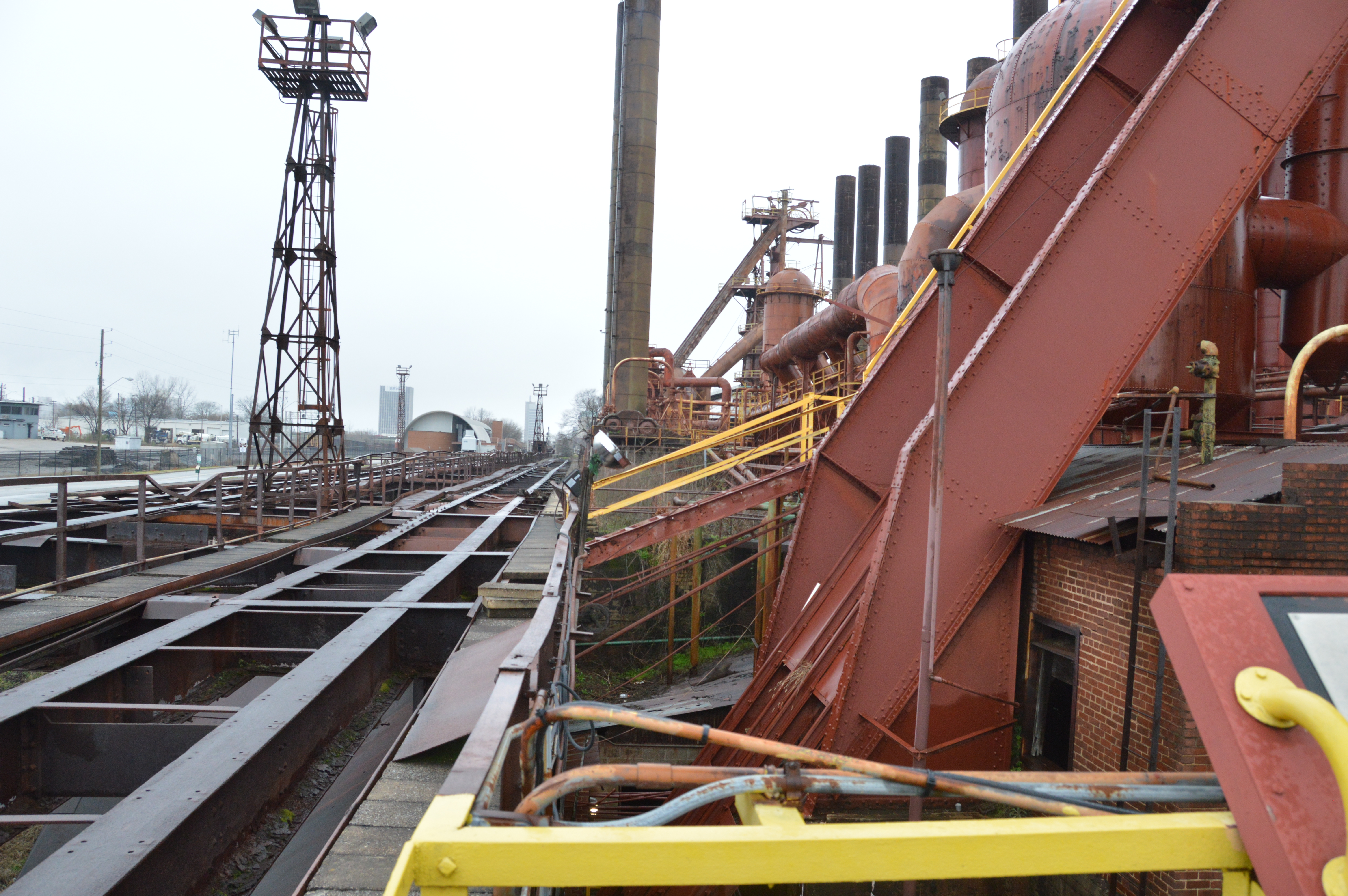
Here is a view of the Sloss high line from just east of the skip hoist for the eastern blast furnace.
20200218 1158

Underneath the tracks are storage bins. And underneath those bins is another track for cars to take the material from the bins to the skip hoists. This is the track under the Sloss high line.

And this is one of the cars that ran on that track.

Likewise, there are bins under the Carrie high line. The weeds are blocking a view of the track that runs under the bins.

This is a view of the "doors" under the bins that are opened when a car is under them. The tour guide spent some time describing how hellish the job was to work here.

This is a photo of the tablet that the tour guide used to show a car being loaded.

The stockpiles used less of today's parking lot than I had imagined.
EarthExplorer: Apr 20, 1972 @ 24,000, AR1VCWT00010065

So I downloaded an older photo and discovered that they didn't store anything in the parking lot area. I had noticed that the high line went east of Minsi Trail Bridge. So it appears the storage piles were much further east of the blast furnaces. That long run to the storage piles would explain why they had so many Larry cars.
EarthExplorer: Apr 10, 1955 @ 24,000, AR1VII000020072

EarthExplorer: Apr 10, 1955 @ 24,000, AR1VII000020072

While EarthExplorer started performing again, I decided to check out Sloss and Carrie as well.

Sloss, like some coal docks, must have stored the materials in hoppers in railyards rather than in storage piles. These were old blast furnaces and thus they were small. So they would not need near as much material as today's furnaces. And Alabama would not have to worry about stocking up material to last them through the winter. A steel industry started in Birmingham because iron ore, coal and limestone could be mined from the nearby mountians.
EarthExplorer: Mar 22, 1947 @ 23,600, AR1DB0000030162

Carrie+Homewood
EarthExplorer: Apr 28, 1949 @ 35,400, AR1DQ0000050078

Same photo, cropped. I included the hot-metal bridge to help correlate this image with today's satellite images.
Digitally Zoomed

I wasn't happy with the quality of the 1949 image so I downloaded a 1952 image. You can clearly see the piles of material piled up next to the high line. And some freight cars on the high line.
EarthExplorer: Apr 9, 1952 @ 23,600, AR1NZ0000020016


The tracks on the left might be part of the high line.
1 of 3 photos posted by Mark Mcdermott
FAIRLESS WORKS ...DOCKS ...ORE YARD
Albert Gresley: I don't know how anything got done at this place. Mill workers would be drinking at the bar and then start bitching that they had to leave to go and clock out, their shift was nearly over.