After this overview map to provide context, I start with a collection of photos taken while the lower dotted line was still in service.
 |
 |
| Lou Gerard posted The Conductor throws the switch so the Division St. job on Kingsbury St. in Chicago can go in a get a car out of the Midwest Zinc siding with caboose #5. October 1989. [This is facing Southish.] |
The water tower is still (Sep 2023) standing.
 |
| Street View, Aug 2021 |
Lou Gerard posted two photos with the comment: "SOO LINE GP9 2550 on Kingsbury south of North Ave. in 1996. A large Whole Foods Market now occupies the area to the left." [These are facing Northish.]
 |
| 1 |
 |
| 2 |
 |
| Dennis DeBruler commented on Lou's post The rail is still exposed north of North Ave. Since the last customer on Goose Island quit using the rail and since General Iron uses barges, I don't think there are any customers left on any of the remnants of the Chicago & Evanston. I went out on about the last warmish weekend in December (2015) to see what rails were left. |
 |
| John J Kulidas posted Picture and description by John Smatlak. A shot of the Milwaukee Road C&E South Line switcher at work on Kingsbury St., switching out Midwest Zinc in the Summer of 1986 in Chicago, Illinois Today this scene has vanished entirely- the tracks have been removed from Kingsbury and the industries are gone (except for Carbit Paint and its iconic water tower). Today gentrification is the word of the day in this once highly industrialized section of Chicago and it’s hard to discern where along Kingsbury this scene even was, but this was just north of Blackhawk Street. A Whole Foods grocery now occupies the former Midwest Zinc site. Dennis DeBruler shared The bobtail bridge north of Kinzie Street that connected the Milwaukee's Chicago & Evanston to Union Station for passenger service was gone. But freight service still had access to Goose Island and Kingsbury Street industries via what is now the 606 Trail. |
 |
| Dennis DeBruler commented on John's post 1938 aerial photo. Back then, the bridge to Goose Island would have gotten a lot of use. https://clearinghouse.isgs.illinois.edu/webdocs/ilhap/county/data/cook/flight10/0bwq08008.jpg |
 |
| Dennis DeBruler commented on his share 1952 aerial photo [AR1SA0000040040] |
 |
| Dennis DeBruler commented on his share Today's view. https://maps.app.goo.gl/5RrBCuFPyLGSHKLm6 |
 |
| David Daruszka commented on Dennis' share Aforementioned bridge. |
The tracks did stop on the north side of North Ave.
 |
| 20151212 7498 |
Several more photos of switching Midwest Zinc, Flickr1, Flickr2
 |
John David Larson posted
A Soo Line switcher "street running" in Chicago south of North Avenue in 1999. Even though Chicago is still the nation's railroad capitol actual freight service in the city like this had all but vanished by this date - and might be completely gone by now.[The last remnant of the C&E, on Goose Island, was abandoned in Feb 2018.] |
A different exposure and a longer description of John David's 1999 photo.
.jpg) |
| John David posted Here is the Kingsbury job on Kingsbury Street in 1999, this view looks north and W. North Avenue is the intersection in the distance. I had no idea how to go about catching this operation. There was a video from about 1990 titled "Today's Chicago Railroads" that included footage of it. Part of the narration named a few of the businesses that received shipments. So, I called one of them and asked "when does the railroad show up to switch this line?". To my surprise, the guy on the other end said "Tuesdays and Thursdays" or some such thing and also about what time. I navigated the congested Chicago streets a few times on the days he gave me and had good luck catching this relic of days gone by. All that remains of this location now to suggest trains used to navigate the pavement is a single rail poking through the asphalt. Steven Cipriano: I think that was a strip club(white building) on the right hand side then a bit further up on the right was a club called Crobar. Christina Smith Guziec: The circus used to bring the animals through town on this rail line all the way into the 1990s. Paul Webb shared Andy Hughes: Christopher Bailey This job was called for abt 730a in Bville. Thiswas when the north track ended at a candy Co at Diversy Av. The south end ended on Goose Island at a lumber co. This was during the brief Soo period and into CP. |
 |
| Austin Shwatal commented on Paul's share view today |
 |
| John J Kulidas posted Milwaukee Road Kingsbury Chicago IL 5-7-86 8 crop Milwaukee Road C&E South Line switcher on Kingsbury Street at Eastman, returning from Wallace Press with some empties. Taken 5/7/86. The old Ogden Ave. viaduct can be seen in the distance. John Smatlak photo |
 |
| John J Kulidas posted Photo by John Smatlak Milwaukee Road on Kingsbury 5-7-86 Chicago. Lakewood Branch switcher heading north on the first block or so of street-running on Kingsbury. The train is returning from Wallace Press where it delivered a few boxcars of paper and picked up the empties. David Partak: I lived 2 blocks from Peerless Candy during this time which received cars of corn syrup & granulated sugar, MILW Division St. Job switched the plant at least 1X weekly. Now Peerless is gone, branch line removed. |
 |
| Mark Llanuza posted (source) Its 1987 Milwaukee Rd Goose Island branch Milwaukee Rd MP-15 is at Halstead and Division street. Brandon McShane The old Ogden Avenue viaduct passing overhead. Michael Plumeri Looking East. It's all gone now. Odgen ave bridge was a great short cut from North ave to the Chicago Stadium. Tom Schultz derailments in the city really sucked also had a few doors fall off in the Chicago put traffic to a stop Truck driver knew how to drive through front yards and side walks to get to them then winch them up and get to nearest dumpster that's where they ended up. Derailments meant we were going to have someones electric shut off for safety reasons. |
 |
| Mark Llanuza posted Its 1987 former Milwaukee Rd MP-15 is at Erie st in Chicago IL switching the goose Island branch. John J Kulidas posted, same comment as Mark's Dave Jendras: This looks to be at Erie & Kingsbury looking east and slightly south - that slightly curved building far right is still there. This then is the other side of the river from Goose Island. The old C&E line Candice Marie Lynn shared Carsey Stamos: That thing was around well into the 2000’/ |
 |
| Mark Llanuza posted Its 1987 Former Milwaukee Rd MP-15 switches at Wards near Erie street in Chicago IL .This was the Milwaukee Rd Goose Island branch. |
 |
| John J Kulidas posted Milwaukee Road / Soo Line Kingsbury Branch (C&E South Line) near Superior & Kingsbury Streets, switching cars for Wallace Press (located just the other side of the elevated roadway in the background) in 1986. This picture captures a time where this area of Chicago was starting to go through a transition from industrial to urban gentrification. Photo by John Smatlak. Michael Mannino: I worked in this neighborhood for four years starting in 1998. All these tracks were gone by then, I think. I also think the cross street is Erie, but I could be wrong again. I do know the viaduct in the background is the Ohio feeder ramp. Bill Matteson: I worked 10 years at Wallace Press Grand Ave And Kingsbury. Edward Kwiatkowski shared |
 |
| Dennis DeBruler commented on Edward's share I think we are looking between the buildings south of Huron Street and then we are looking along Kingsbury Street. (The hash marks in Larrabee Street is how topo maps indicate street running.) 1972 Chicago Loop Quad @ 24,000 |
 |
| Dennis DeBruler commented on Edward's share A diagonal building fills the right-of-way (RoW) between Huron and Erie Streets. And there is some extra parking north of Huron. https://www.google.com/maps/@41.8944224,-87.6422407,253m/data=!3m1!1e3 |
 |
| Dennis DeBruler commented on Edward's share As indicated by the topo map, the RoW used an easement east of Kingsbury when it got south of Ontario. The National Public Housing Museum and parking spaces now occupy that land. Note that the Ontario Street Lofts building is curved to accommodate the industrial spur shown on the topo map. Wallace Press was in the northwest quadrant of Kingsbury and Grand. I wonder if that is the building now used by the Riverbank Lofts Condo Association. https://www.google.com/maps/@41.8923399,-87.6404579,247m/data=!3m1!1e3 |
 |
| John J Kulidas posted Milwaukee Road C&E South Line switcher downtown Chicago sorting out cars for Wallace Press, 5/7/86. Note the C&NW terminal in the distance just below the Sears Tower. Photo by John Smatlak. Owen Austin posted Milwaukee Road C&E South Line switcher downtown Chicago sorting out cars for Wallace Press, 5/7/86. Note the C&NW terminal in the distance just below the Sears Tower. Photo by John Smatlak. |
 |
| John Smatlak commented on John's post Yikes- that's really a poor quality version of my photo- here's a better one. Fun memories all these years later! Derek A. Walsh: John Smatlak Were the close rails disconnected behind you? Those are some rather confident parking jobs. Great shot! John Smatlak: Derek A. Walsh Yes- by this date the trackage had been rationalized leaving only a runaround track and a single track out to the one remaining customer (Wallace Press located at Grand Ave). David Thompson: One minor item, the building with the C&NW on it was at the time headquarters at 111 N. Riverside Dr. but experts would need to confirm this. [I think it was confirmed.] |
The first part of the route to the south is easy to trace because it did street running down Kingsbury Street.
 |
| .pdf copy from 1915 Smoke Abatement Report |
 |
| .pdf copy from 1915 Smoke Abatement Report |
 |
| Satellite |
 |
| .pdf copy from 1915 Smoke Abatement Report |
The smoke abatement report omits some of the yard tracks that were south of Grand. This photo shows that Milwaukee occupied most of the land from Grand to Kinzie between Kingsbury and the river.
 |
| Copyleft (CC BY-NC-ND): Copelin Commercial Photographers, "Bridges, viaducts, and underpasses: Ashland Ave. and Belmont Ave., Image 2", James S. Parker and Chicago Photography (University of Illinois at Chicago) William Russ posted a different exposure
[The road bridges are Kinzie in the foreground, Grand in the middle and Erie in the left background.]
Paul Petraitis shared |
 |
| Jeff Bransky commented on William's post David H. Nelson commented on Paul's share |
The East Bank Club was one of the first gentrification conversions of railroad land along the North Branch. When it was built, it had just a blank wall on the river side. It became a textbook example of how not to develop land along the river. I see they have since worked on their river side.
 |
| Street View |
Where Kingsbury joined Larrabee, the C&E went past the Montgomery Ward Warehouse.
On the north side of the warehouse, there were industrial spurs that served the warehouse.
 |
| Street View |
 |
| 1938 Aerial Photo from ILHAP at photo resolution |
And this is what the East Bank Club land used to look like.
 |
| 1938 Aerial Photo from ILHAP at photo resolution |
 |
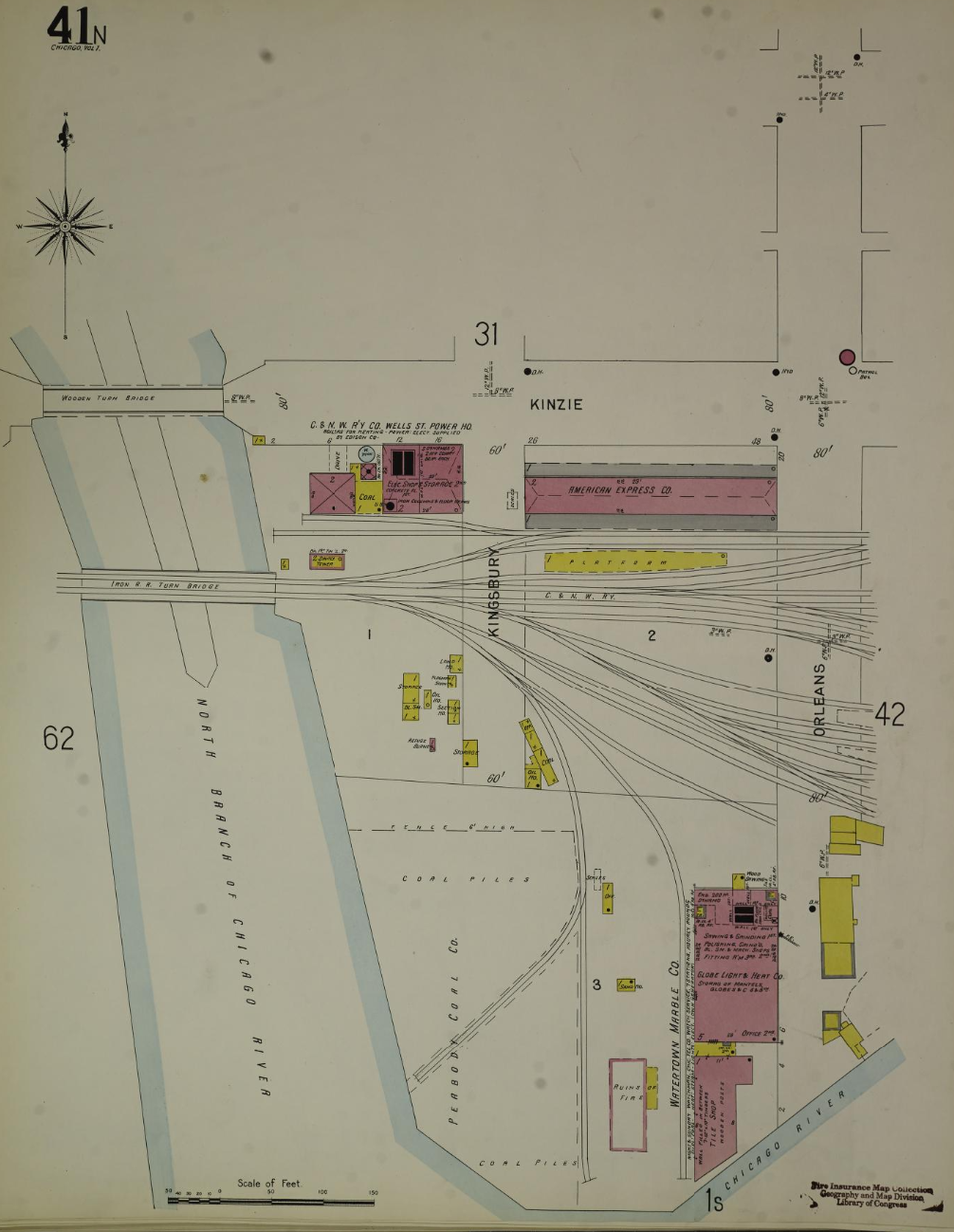
| Image 18 via Index via Vol 1 North, 1906 via Chicago |
 | |
|
No comments:
Post a Comment