The CRCW was built to reduce Chicago's usage of Great Lakes water.
 |
| MWRD |
 |
| MWRD posted A view of the west cofferdam for construction of the Chicago River Controlling Works (CRCW) with the Chicago skyline and the under-construction DuSable Lake Shore Drive bridge visible in the background on September 30, 1936. |
 |
| MWRD posted on Jan 22, 2023 Construction of the Chicago River Controlling Works and Lock on November 12, 1936. |
 |
| MWRD Posted Construction of the Chicago River Controlling Works and Lock on November 16, 1936. |
 |
| MWRD posted Construction of the Chicago River Controlling Works (CRCW), including the Chicago Harbor Lock, on March 19, 1937. |
 |
| Paul Jegerski commented on MWRD's post |
 |
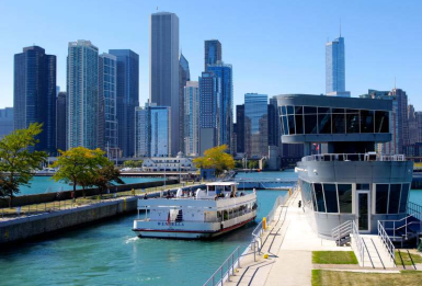
| MWRD A view of the Chicago Harbor Lock and Navy Pier on August 30, 1938. The MWRD built the Chicago River Controlling Works (CRCW) and the lock between 1936 and 1938, and operated the lock until 1984 when the U.S. Army Corps of Engineers took over operations. The MWRD continues to operate the CRCW sluice gates, and you can learn more about how the MWRD uses CRCW and other structures to manage the Chicago Area Waterway System here https://mwrd.org/chicago-area-waterway-system Navy Pier U.S. Army Corps of Engineers, Chicago District MWRD posted again on Apr 27, 2023 |
MWRD posted three photos with the comment:
Three views of construction of the Chicago River Controlling Works (CRCW), including the Chicago Harbor Lock, on March 19, 1937. The MWRD built CRCW and the lock between 1936 and 1938, then operated and maintained both until 1984 when the US Army Corps of Engineers took over operations of the lock.
The MWRD continues to operate the CRCW sluice gates. Learn more about how the MWRD uses CRCW and other structures to manage the Chicago Area Waterway System here: https://mwrd.org/chicago-area-waterway-system
 |
| 1 [The barge at the end of the cofferdam construction reads Great Lakes Dredge & Dock Co.] MWRD posted on Aug 18, 2022 Construction of the Chicago River Controlling Works (CRCW), including the Chicago Harbor Lock, on March 19, 1937. The MWRD built CRCW and the lock between 1936 and 1938, and operated the lock until 1984 when the U.S. Army Corps of Engineers took over operations. The MWRD continues to operate the CRCW sluice gates. MWRD posted again |
 |
| 2 [We can see the length of the pilings that they are driving to hold the foundation of the lock.] |
 |
| 3 MWRD posted |
2 of the 6 photos posted by the USACE, Chicago District.
 |
| 1 |
 |
| 2 |
This lock has the very unusual design of not having huge conduits and valves in the side walls to fill the chamber. Instead, they simply open the gate a little bit to let the water flow in. Can you imagine how much water used to flow down the Chicago River before the piers and lock were built?
 |
| Brandon Ham, Jan 2020 |
This lock uses sector gates like the O'Brien Lock does.
 |
| Satellite |
In addition to the lock, the CRCW includes sluice gates to allow a controlled amount of water to flow into the river.
 |
| 3D Satellite |
Some views of the CRCW that include the Navy Pier.
 |
| Eddie Yung posted The good old "S" curve on LSD. Lake Shore Drive. Ginny Teister Morton This definitive S-Curve photograph, was taken from the Prudential building in 1963 by the venerable Charles Cushman. Bob Lalich The white buildings along Ogden Slip were known as North Pier Terminal. |
 |
| Johnny Conlisk shared his web page Navy Pier, possibly in the early 1960s, with 5 ocean-going ships along side. Note the skyline and the FDR Lake Shore Drive Bridge in the distance. This was just after the opening of the St Lawrence Seaway, a system of locks & canals that allowed ships from the Atlantic Ocean to go to the far reaches of the Great Lakes. Only a few years later, the advent of container shipping made it far cheaper to ship containers of goods from foreign ports to US coastal cities and on to Chicago by truck or rail. When that happened the Pier fell into disuse until the 1980s, when it was turned into an entertainment venue. It is currently one of Chicago's most popular tourist destinations. Photo: A Pictorial History of the Great Lakes - Read more about it here http://johnny-sells.com/when-chicago-was-an-international-…/ |
A view of the CRCW that includes the Ogden Slip.
 |
| David Daruszka posted |
Lake Michigan is typically 2-5 feet above the Chicago River. [USACE] (Another source specifies 1-4 feet.) The lock gates have been designed to handle situations when the river is higher than the lake. This can happen during a heavy rainstorm. (Although MWRD has been spending billions of dollars for decades on their TARP plan to reduce these events.) Another reason the river can be higher than the lake is a drought in the Great Lakes watershed. One happened in 2013. [ChicagoTonight] (I was shocked that Henderson said: "It’s 70 percent sewage. A large part of it is untreated. A lot of human sewage is in that, and what would be happening is the Great Lakes would start to be filling up with human sewage from the Chicago region. That’s a problem." That was true a century ago. But it is not true now. Even in the 1800s, "filling up" would be hyperbole. But it could reach the Water Cribs. Then, when I went back in the article and saw that Henderson is speaking for the Natural Resources Defense Council (NRDC), I was angry. He is either very ignorant or lying, neither one is good for a spokesperson. Now I can't trust anything that the NRDC says!)
There are now studies being made to separate the Great Lakes and Mississippi River Basins (i.e reverse the reversing), but it is because of Asian Carp, not because of the 2013 fear that the Great Lakes were running out of water. In fact, in 2017 Lake Ontario was experiencing record high water levels causing erosion problems and threatening to close down the St. Lawrence Seaway during the shipping season.
The MWRD installed a control lock for two reasons --- water rights and the 1930's 9-foot navigation channel project.
 |
| MWRD posted A view to the west showing part of the recently completed Chicago Harbor Lock and Chicago River Controlling Works (CRCW) on September 1, 1939. The MWRD built CRCW and the Chicago Harbor Lock between 1936 and 1938 and operated the lock until 1984 when the US Army Corps of Engineers took over operations. The MWRD continues to operate the CRCW sluice gates. Visit https://mwrd.org/chicago-area-waterway-system to learn more about how the MWRD uses CRCW and other structures to manage Chicago area waterways. MWRD posted on Jul 7, 2023 USACE, Chicago District posted The Chicago Harbor Lock is a critical infrastructure project designed to control water flow, prevent sewage contamination in Lake Michigan, and facilitate vessel passage. Filling and emptying are gravity-fed through partially opened lock gates, and there is typically a two to five-foot difference between Lake Michigan and Chicago River water levels. Essentially, it is a water elevator! Here is a photo facing west, showing the city skyline behind the lock in 1939. Photo courtesy of MWRDGC. |
 |
| protectnepa The gates were replaced around 2019. "Today, the Chicago Lock is fourth in the nation in terms of commercial lock usage and second in the nation in terms of recreational lock usage. On a busy day, 50-100 vessels can be locked at once." |
 |
| Barry Butler Photography posted Polar Vortex 2019 Day Two on this day [Jan 31] six years ago. I was in a helicopter at minus-12 F / minus-24 C. Oh, with the door off on my side of the helicopter. My pilot looked like a mummy...almost no skin exposed except his eyes. It was brutally cold, but worth the effort. Aerial view of the impact to Chicago. Lloyd Scott Hardin posted Just the left of navy Pier is the Chicago controlling lock and the Chicago river. |
Water Rights
Water rights is a big deal out West. The water of the Colorado River watershed is used by so many different political entities that now it is barely a trickle when it reaches Mexico. For example Denver helped pay for the Moffat Tunnel because it not only has a hole under the Continental Divide for a railroad, it has a hole for water.
 |
| Satellite |
In 1909, a Boundary Waters Treaty between the United States and Canada was written to form a commission to regulate water use with this sequence of priorities; domestic & sanitary, navigation, and power & irrigation. Since, at that time, Canada was a providence of England, the treaty was ratified by William Taft and King Edward VII. There were several rivers in dispute, but the Chicago Diversion lowering the lake level by 6 inches was one of the motivators for a commission to consider the "big picture." [Wikipedia1] Compacts were written in 1985, 2001, and 2005-2015 to detail how the states and Providences use the Great Lakes water supply. (The 2005-2015 range is an example of why I tend to ignore legal aspects of industrial history. An "agreement" was signed in 2005. A "compact" was written in 2007 to document details of usage. It became law in the US in 2008. But changes were needed to satisfy Canada before "coming fully into force" in 2015. [Wikipedia2, Wikipedia3]
As part of digging the Chicago Sanitary and Ship Canal (CS&SC), MWRD also widened and deepened the Chicago River to increase the amount of water that would flow from the lake.
Because Wisconsin sued Illinois to quit draining Lake Michigan to flush its sewage down the river, MWRD started building Wastewater Treatment Plants (WTP) after the Supreme Court agreed with Wisconsin in 1929. [Wikipedia4]
9-Foot Navigation Channel
When they built the CS&SC, it terminated at a control structure where it was about the same level as the nearby Des Plaines River. The high flow in the river did not bother the steamboats that navigated the Illinois River because they were used to going upstream against rapidly flowing water over the rapids in the river. But in the 1930s, several dams and locks were built between Lake Michigan and the Mississippi River to create a 9-foot navigation channel. One of the projects was the MWRD building a canal with embankments on both sides along the 38-foot drop of the Des Plaines River with a powerhouse and lock at the end. The chain of dams on the Illinois and Des Plaines River formed a series of pools that were at least 9 feet deep. Barge operators do not want to go upstream against a strong flow of water. They want those pools of water to be as still as possible. In fact, during high flows caused by floods, they will shut down operations.
 |
| USACE |
Since the WTPs removed the need for a strong flow and since the 9-foot navigation channel project made a strong flow undesirable, the control lock was built to stop the water flow into the river.
Years later, people learned that MWRD's usage had a small impact on the water level of Lake Michigan and Lake Huron. (They are one body of water as far as elevation is concerned.) Climate has a much greater impact. I have already described that we saw record lows in 2013 and record highs in 2017, just four years later.
 |
| Chicago Tonight, 2013 |
 |
| Street View, 2017 |
I remember a few decades ago when the water levels were approaching a record high that Chicago was asked to open both sets of gates on the lock and let the water flow at the original high rate. They said no. If the lake was around record levels, that means about a five foot difference. Imagine what, say, the site seeing boats would do with five feet less clearance below the bridges and trying to dock in a fast flowing river. The bear trap dam has been removed from the water control structure, so the canal would probably now flood with the higher flow. And barge operators do not want to see a fast flowing CS&SC and Des Plaines River.
Furthermore, the EPA now understands how many toxins are in the river sediment. The Chicago Tribune built its new printing plant along the Chicago River because it planned on receiving newsprint from boats as it had at its old plant. But the EPA would not allow them to dredge the river to make room for the boats because they determined the river sediment was full of toxic material. Dredging would allow the toxins to escape into the water. Opening the lock gates to allow a strong river current might also stir up the river sediments.
Furthermore, the EPA now understands how many toxins are in the river sediment. The Chicago Tribune built its new printing plant along the Chicago River because it planned on receiving newsprint from boats as it had at its old plant. But the EPA would not allow them to dredge the river to make room for the boats because they determined the river sediment was full of toxic material. Dredging would allow the toxins to escape into the water. Opening the lock gates to allow a strong river current might also stir up the river sediments.
Chicago no longer needs, nor wants, water to flush its river. But its water filtration plants do draw a lot of water from the lake. I leave Water Commission issues concerning water supply usage for another post.
USACE, Chicago district posted two photos with the comment:
The Chicago Harbor Lock control house was replaced in 2007 with a more modern facility, which consolidated maintenance into one building and allows for near 360-degree visibility – improving security and speeds lockages during heavy traffic periods.In 2011, the Corps’ Chicago District completed a project to replace the structural steel sector gate leaves and associated hydraulic operating machinery. The new lock gates are designed to reduce repair and maintenance costs and prevent service disruptions.
 |
| 1 |
 |
| 2 |
There are actually another basically identical two pairs of sluice gates on the south side of the controlling works at the northwest corner of DuSable Harbor, and they are actually the primary ones.
ReplyDelete41.88726954572421, -87.61259036823299
The south sluice gates were originally located at the southeast end of what would become DuSable Harbor. But sometime around 1999/2000, the south wall of the controlling works was moved from there north so as to shrink the area of walls that could be subject to leakage. In short, they shortened the perimeter of the controlling works. In that former south section of the harbor they created DuSable Harbor Marina.
Also, the south sluice gates apparently have pumps. Though, the pumps can only be used to return excess diversion to Lake Michigan. The UASCE says that they have yet to be used, however. You'd imagine that they could also technically be used to help during backwashes into the lake, too, but that is never mentioned as a function. Perhaps it's because it would be enough of a difference to matter; just a guess.
Finally, the sluice gates on the northeastern wall of the works are only used to clear debris, such as ice, from the from the enclosed. Though, it's kind of hard to see how it creates enough of a current for that, but that's what I read, somewhere.
I feel like you're taking the NRDC rep too literally. He's using 'sewage' loosely, here. It's technically called effluent, but that's really just a euphemism for treated sewage. And more than that, it's just: during much of the year, the VAST majority of the water in the CAWS is effluent. And though treated - though, only relatively recently disinfected - it's not something you'd want pumped out into the lake if you can help it, and it's precisely why discretionary water is still used to dilute and flush it, because especially during droughts in warmer weather, it can still stink to high heaven.
ReplyDelete