Somewhere I read that this project was bigger than the Panama and Suez Canals combined. But now I can't find where I read that.
 |
| Jenish, p12 |
I have written notes for some of the locks:
And Welland Canal describes some more locks. Some of the locks also have a nearby bridge. Other bridges are:
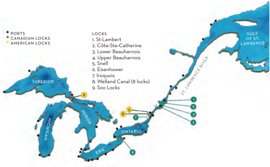
When I checked my canal dimension notes, I was reminded that a series of canals and locks had already been built to accommodate ships. But they were small ships called "canallers" that were restricted to 250' x 48' x 15.5'. The construction of the Seaway in the late 1950s increased the ship size to 740' x 78' x 26.5' with a clearance above the water of 116.5'. The fourth Welland Canal was 766' x 80' x 25 in 1932. The length and width was not an issue, but obviously it had to be deepened in the 1950s to meet the Seaway standards. The largest lock in the Soo Canal, Poe Lock, has the dimensions of
1200' x 110' x 32. I was surprised by the 1200' because the longest boat on the Great Lakes is currently 1006'. A ship that is small enough to go through the Seaway is called a "saltie." A ship that will fit only in the Poe Lock is called a "laker."
 |
| Overview |
 |
| Vivid Maps Great Lakes Lighthouse Keepers Association posted [A lot of comments were asking where is Lake Michigan. I had to look twice myself before I noticed it is down at the bottom of Lake Huron. That is because the lakes share the same surface elevation.] Don Slusser shared |
 |
| greatlakes-seaway via "Strike Closes St. Lawrence Seaway" 11:54 video @ 3:38 |
 |
| greatlakes-seaway and 3:49 |
(new window)
 |
| ABCs |
I learned when I researched the Iroquois Lock that they did not achieve the 26.5' depth by digging that deep. Instead they used a combination of some digging and of dams raising the water level. The problem with raising the water level is that it would flood three towns. In 1954, "Some 6,500 people are moved to new homes and some 550 dwellings are transported to waiting foundations in the new Ontario towns of Long Sault, Ingleside and Iroquois." [greatlakes-seaway] See Iroquois Lock for references to some before and after photos of moving the town.
Below is the highest bow splash I have seen, but the waves don't look that high to me.
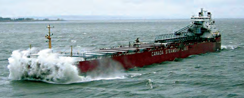 |
| www.boatnerd.com from Jenish, p16 CSL’s Assiniboine was one of four of the company’s vessels to receive a new forebody over the past decade. Each is now a seawaymax ship: 740 feet long and 78 feet wide |
 |
| Philip Menici posted St. Lawrence River Project mid and late 1950s Philip Menici  Bert Baumgartner This particular photo was in the Massena NY area there were 5 contracts allowing shipping dams and power production from Quebec into the Great Lakes Bert Baumgartner This particular photo was in the Massena NY area there were 5 contracts allowing shipping dams and power production from Quebec into the Great Lakes |
 |
| 13:22 video @ 1:18 2026 Marks the Latest Closing of the St Lawrence Seaway System Since its Opening in 1959 |
During the 1960s, salties used Navy Pier as a pier.
During the 1970s and 80s, ships and industry were moved to the Calumet River area. There used to be at least a half-dozen grain elevators along the Calumet River such as the Irondale and Garvey Now there are just two on the lake and one on the river.
While researching the land use south of the mouth of the Calumet River, which began as a steel mill, I found a couple of ships in the river in a 2000 image.
Life on a Laker: video, print The CSL Welland started work in 2015. It was carrying grain from Thunder Bay to an ocean going ship. It doesn't have a self-unloader.
No comments:
Post a Comment