I have already posted external and internal views of the Lockport Powerhouse. This MWRD posting gives me an excuse to find my old lock (built in 1907) and spillway photos.
 |
| MWRD posted The Lockport Powerhouse, dam and lock, on December 28, 1907. |
This photo is different because a man is standing on the divider between the canal and outlet.
 |
| MWRD posted, probably cropped |
This picture still has the railroad trestle that was built to move equipment into the powerhouse for construction and maintenance. The concrete structure on the left is the west wall of the original lock. When that lock was opened in 1907, it had the highest lift in the world at 38 feet. [Sign on chain link fence by the lock.] (HAER says that it had a 40' lift and that it was completed in 1910. AmericanCanals says 41'.)
 |
| MWRD posted A view looking south from the top of the dam between the original MWRD lock, at left, and the Lockport Powerhouse, at right, on June 19, 1923, in Lockport, Illinois. |
Please see AmericanCanals for some historical photos of the lock.
 |
| MWRD posted on May 14, 2022 Officials touring the nearly completed Lockport Lock and Powerhouse on August 4, 1907, with a portion of the powerhouse visible at left and the lock gates at right. MWRD posted Officials visit the nearly completed Lockport Powerhouse and Lock on August 4, 1907. The powerhouse and dam are still in operation, but the original lock was later replaced by a much larger lock, built by the state of Illinois and the federal government and opened in 1933, which provides the means for movement of larger vessels between the Des Plaines River and the Chicago Sanitary and Ship Canal. |
 |
| HAER-data, p16 from HAER |
MWRD posted three photos with the comment:
Today's photos show construction of the Lockport Lock and Dam on May 28, 1907, and officials touring the nearly completed lock and powerhouse later that summer on August 4, 1907, with a portion of the powerhouse visible at left and the lock gates at right. The powerhouse and dam are still in operation but the original lock was later replaced by a much larger lock, built by the state of Illinois and the federal government and opened in 1933, which provides the means for movement of larger vessels between the Des Plaines River and the Chicago Sanitary and Ship Canal. We're also including a recent aerial view of the two locks to provide a side-by-side comparison.
 |
| 1 |
 |
| 2 |
 |
| 3 |
 |
| MWRD posted Construction of the Lockport Lock on April 11, 1907. The lock and the adjacent powerhouse and dam were completed later in 1907. The powerhouse and dam are still in operation but the original lock was replaced by a much larger lock, built by the state of Illinois and the federal government and opened in 1933. Learn more about managing the Chicago Area Waterway System here: https://mwrd.org/chicago-area-waterway-system |
 |
| MWRD Construction of the Lockport Powerhouse, Lock and Dam on April 11, 1907, looking south from the west wall of the Chicago Sanitary and Ship Canal with the fender wall in the foreground and the powerhouse in the background. The powerhouse and dam are still in operation but the original lock was later replaced by a much larger lock, built by the state of Illinois and the federal government and opened in 1933, which provides the means for movement of larger vessels between the Des Plaines River and the Chicago Sanitary and Ship Canal. |
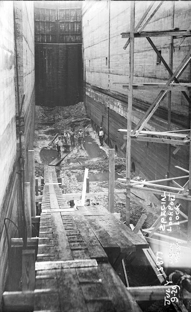 |
| MWRD posted on Jan 13, 2022 Workers inside the Lockport Lock for gate repairs on July 9, 1929. Located at the termination point of the Chicago Sanitary and Ship Canal (CSSC) near Lockport, Illinois, the Lockport Powerhouse and the adjacent lock and dam are used to maintain water levels, provide movement for commercial navigation between the CSSC and the Des Plaines River, and to generate electricity. Learn more here https://mwrd.org/lockport-powerhouse MWRD posted |
 |
| MWRD posted Workers making repairs in the Lockport lock on May 13, 1924. The lock was replaced by a much larger lock by the state of Illinois and the federal government in 1933. MWRD posted Frank Giovetti: dangerous standing under that 40' decayed brick wall, after the water subsides |
 |
| MWRD posted Inspection during repairs for the Lockport Lock gates on May 13, 1924. |
 |
| 20140614 0285rc |


As we walked across it to the lock, I took his upstream view to capture the top of the sluice gate, the debris screen, and the floating debris.


 |
| Justin Marshall posted |
 |
| Bob Dodge commented on a post |
 |
| Bob Dodge commented on a post Dennis DeBruler You can see the diagonal tiebars. |
 |
| Justin Marshall commented on his post |
 |
| Justin Marshall commented on his post |
 |
| Justin Marshall commented on his post |
 |
| Bob Dodge commented on a post |
 |
| MWRD posted on Mar 6, 2022 Inspection during repairs for the Lockport Lock in Lockport, Illinois, on May 13, 1924. The original lock was later replaced by a much larger lock, built by the state of Illinois and the federal government and opened in 1933, which provided the means for movement of larger vessels between the Des Plaines River and the Chicago Sanitary and Ship Canal. |
 |
| MWRD posted on Mar 12, 2022 Repairs to a portion of the 48-foot dam at the Lockport Powerhouse in Lockport, Illinois, on August 9, 1928. MWRD posted again |
Note the original lock between the powerhouse and the current lock.
 |
| USACE, Rock Island District posted via Dennis DeBruler |
I can't tell are the upstream gates sealed off from the canal? I'm trying to figure out if they can still use it as a sort of extra sluice/spillway when needed or its its been concreted off.
ReplyDeleteThe lock has been sealed. But the spillway just west of it is usable.
Deletehttps://www.google.com/maps/@41.5697524,-88.0780392,68m/data=!3m1!1e3
Only two of the units in the powerhouse are now used for power. The others can be used to pass excess water.
And they still have some sluice gates up at the original control works:
https://www.google.com/maps/place/Lockport+Controlling+Works/@41.5978101,-88.0668607,344m/data=!3m1!1e3!4m6!3m5!1s0x880e5d10e432e189:0xe1ce19c700aa45f7!8m2!3d41.5980178!4d-88.066008!16s%2Fg%2F11scpkgj0r